
Snowdonia or Eryri is a mountainous region and national park in northwestern Wales.
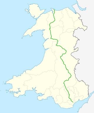
The A470 is a trunk road in Wales. It is the country's longest road at 186 miles (299 km) and links the capital Cardiff on the south coast to Llandudno on the north coast. While previously one had to navigate the narrow roads of Llanidloes and Dolgellau, both these market towns are now bypassed due to extensive road modernisation. The 26 miles (42 km) from Cardiff Bay to Merthyr Tydfil are mainly dual carriageway, but most of the route from north of Merthyr to Llandudno is single carriageway.

Llandudno is a seaside resort, town and community in Conwy County Borough, Wales, located on the Creuddyn peninsula, which protrudes into the Irish Sea. In the 2011 UK census, the community – which includes Gogarth, Penrhyn Bay, Craigside, Glanwydden, Penrhynside, and Bryn Pydew – had a population of 20,701. The town's name means "Church of Saint Tudno".

Llanrwst is a market town and community on the A470 road and the River Conwy, in Conwy County Borough, Wales, and the historic county of Denbighshire. It developed round the wool trade and became known also for the making of harps and clocks. Today, less than one mile from the edge of Snowdonia, its main pursuit is tourism. Notable buildings include almshouses, two 17th-century chapels, and the Parish Church of St Grwst, which holds a stone coffin of Llywelyn the Great. The 2011 census gave it a population of 3,323.
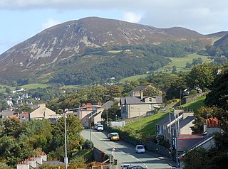
Penmaenmawr is a town and community in Conwy County Borough, Wales, which was formerly in the parish of Dwygyfylchi and the traditional county of Caernarfonshire. It is on the North Wales coast between Conwy and Llanfairfechan and was an important quarrying town, though quarrying is no longer a major employer. The population of the community was 4,353 in 2011, including Dwygyfylchi and Capelulo. The town itself having a population of 2,868 (2011).

Llysfaen is a village and community in Conwy County Borough overlooking the north coast of Wales, and situated on the hill Mynydd Marian. For local government purposes, it is also a ward. The community includes the Peulwys estate of Old Colwyn.

Mochdre[ˈmoːχdrɛ](listen) is a village and an electoral ward to the west of Colwyn Bay in Conwy County Borough, Wales. Originally part of the municipal borough of Colwyn Bay prior to local government reorganisation in April 1974, it is now a separate community whose population at the 2001 census was 1,862 increasing to 1,923 at the 2011 census. The village can be seen in its entirety from Bryn Euryn.

Saundersfoot is a large village and community in Pembrokeshire, Wales. It is near Tenby, both being holiday destinations. Saundersfoot lies in the Pembrokeshire Coast National Park and on the Pembrokeshire Coast Path. The village population was 3,361 in 2011. while the community had a population of 2,628.

Llanrhychwyn is a hamlet in Conwy county borough, Wales. It lies in the Conwy valley, less than a mile south of Trefriw, and a mile north-west of Llanrwst. Today neighbouring Trefriw is a village with a population of around 600, but in the time of Llywelyn Fawr, and up to the early 19th century, Llanrhychwyn was larger than Trefriw, which consisted simply of "a few houses here and there". Indeed, even today both Trefriw and Llanrhychwyn lie within the parish of Llanrhychwyn. The area around Llanrhychwyn had a population of only 178 in 2011.

Llangelynnin is a former parish in the Conwy valley, in Conwy county borough, north Wales. Today the name exists only in connection with the church, a school in the nearby village of Henryd, and the nearby mountain ridge, Craig Celynnin.

Henryd is a village and community on the western slopes of the Conwy valley in Conwy county borough, north Wales. It lies about 2 miles (3.2 km) south of Conwy, off the B5106 road. At the 2001 census, it had a population of 594, increasing to 715 at the 2011 census.
Llandanwg is a village in the Ardudwy area of Gwynedd, in Llanfair community Wales. It is situated on the coast, has a railway station, and a medieval church in the sand dunes behind the beach which is a Grade II listed building.

Llangelynnin is a small village and community near Tywyn, Gwynedd, Wales. Although the village is usually known as Llangelynnin in English, the community name used was Llangelynin though now its also "Llangelynnin".

Llanfachreth is a settlement approximately three miles north-east of Dolgellau, Gwynedd, in the community of Brithdir and Llanfachreth within the historic boundaries of Merionethshire, Wales.

Dwygyfylchi is a village in Conwy County Borough, Wales. It is part of the community of Penmaenmawr which has a population of 4,353. The electoral ward of Capelulo which includes Dwygyfylchi had a population of 1,485 in 2011. It forms part of the historic county of Caernarfonshire.

Llanegryn is a village and a community in Gwynedd, north-west Wales. It was formerly part of the historic county of Merionethshire. It is located within Snowdonia National Park south of the Snowdonia (Eryri) mountain range. Travelling by road, it is around 4 miles (6 km) north-east of Tywyn and 17 miles (27 km) south-west of Dolgellau. The nearest railway stations are at Tonfanau and Llwyngwril, both less than 3 miles (5 km) away.
Llanddulas and Rhyd-y-foel is a community in Conwy County Borough, in Wales. It is located on the coast of Liverpool Bay, at the mouth of the Afon Dulas, 2.7 miles (4.3 km) west of Abergele, 3.6 miles (5.8 km) east of Colwyn Bay and 9.0 miles (14.5 km) east of Conwy. As the name suggests, it consists of the villages of Llanddulas and Rhyd-y-foel. At the 2001 census the community had a population of 1,572, reducing slightly to 1,542 at the 2011 census.
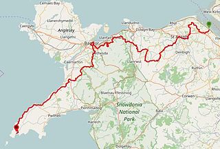
The North Wales Pilgrim's Way is a long-distance walking route in North Wales, running from near Holywell in the east to Bardsey Island in the west. The first half of the trail takes an inland route, with the second half following the north coast of the Llŷn Peninsula. It measures 133.9 miles (215 km) in length, and was officially launched at Porth y Swnt, Aberdaron on 10 July 2014.


