Akyatan Lagoon

Last updated
Akyatan Lagoon
Turkey adm location map.svg
Red pog.svg
Location Çukurova, Turkey
Nearest city Adana
Coordinates 36°37′00″N35°16′00″E / 36.61667°N 35.26667°E / 36.61667; 35.26667
Area147 km2 (57 sq mi)
Established1987
Designated15 April 1998
Reference no.943 [1]
  • MPA Global category: Marine MPA, Intertidal MAP

Akyatan Lagoon is a 14700-hectare wetland ecosystem that is designated as Wetland of International Importance by Ramsar Convention. [2] A major stopover for migrating birds, Akyatan is recognized as an Important Bird Area by BirdLife International. It is the single largest green turtle rookery at the Mediterranean, holding 43% of the Mediterranean nesting population. [3]

Contents

The lagoon is located at the northeastern edge of Mediterranean Sea, 30 km south of the city of Adana, in Cilicia region of Turkey. The entrance to the lagoon is either from Tuzla or through Küçük Karataş Village.

Geology

Akyatan lake and the lagoons were formed during the 4th era (10,000 years ago) when water levels at the Mediterranean started changing. As the rivers that make up the delta flooded, a large swamp came into being at the location where there is Akyatan lake. The swamp then disconnected from the sea and took its shape today with the sand brought by the waves that formed a cord. It is a typical alluvial dam lake.

With the decrease in the amount of water that feeds the lake and with high levels of evaporation, the area of the lake shrinks during summer. At the dried areas, mud surfaces form and by the end of summer the lake completely dries. Mud surfaces are seen especially at the west and northeast part of the lake. Around Kapı village, some islets reach the land.

The lake has a connection to the sea through a 2 km narrow canal on the southwest side. There is a flow of water from the canal to the sea, when the water levels of the lake are high. When the water levels on the lake are low, the flow is from the sea to the lake. This results in the salt ratio of the lake varying throughout the year. In winter and spring, the lake water is fresh with rain and the waters carried by drainage canals. In the summer time, lake is very salty due to the high evaporation and the water flow from sea to the lake. Also, salt ratio is high at the areas close to the sea connection, and low at the northern sections of the lake where the drainage waters and leakage is effective.

Turkey's largest sand dunes are in the area between the lake and the sea. The dunes extend as wide as 3 kilometers and rise as high as 20 meters. In between the dune hills, that line up along the coast, depression goes below the sea level.

At the shores of the lake, there are swamps and reedbeds which vary in size depending on the fresh water leakage. North of the lake is surrounded with vast farmland.

Function

Deltas in the conservation area are one of the most fertile lands in the world, where the micro and the macro flora production reaches very high levels. The food network, that is formed by high fertility, feeds and shelters a rich wildlife with wide variety of species especially waterfowls.

Deltas are places for fish to lay their eggs and young fish to feed and get protected. Two-thirds of the fish that come to the dinner tables live most of their lives at deltas and other wetlands. This makes deltas very important in terms of the future of fishing.

In winter, as the wetlands in Central Anatolia freezes, many waterfowls inhabit the wetlands of Akyatan. Being on the migration route, Akyatan also hosts huge flocks of birds from many different species. This makes Akyatan lake increasingly important.

Serapias at Akyatan Serapias bergonii at Akyatan.jpg
Serapias at Akyatan

Variety of habitats and rich plant and animal collection makes Akyatan an outdoor laboratory for scientific studies. Akyatan also, with the function of balancing base water and preventing salty water from the sea entering into the interior, has contribution in regulating region's water regime.

Akyatan lagoon acts as a multipurpose wetland ecosystem, serving the surrounding communities by creating economy through fishing and by providing recreation. Recreation activities at the lagoon are wildlife watching, hiking, and recreational fishing.[ citation needed ]

Flora and vegetation

Turkish-Iranian and Mediterranean plant geography dominates the area that Akyatan lagoon is situated. Variety of living environments, provides the evolution of plant species that have different ecological inclination. The most interesting section of the nature reserve in terms of plants are the sand dunes between the lake and the sea. Oleander and acantholimon dominates the section, from the lagoons climbing up to the dune hills. At the inner section, broomrape, kidney weed, common vetch and alfalfa is plenty. The shrub species of the reserve are myrtle, blackberry and common smilax. The dune valleys are covered with early spider orchid, serapias and orchis spitzelii.

Afforestation project started in 1955 for stabilizing the dunes and so far, 3687 hectares of dune area has been afforested. Eucalyptus, acacia saligna, robinia, stone pine, Turkish pine and cupressus is used for afforestation.

At the section that are affected by fresh water, there are rush, reed, water lily and yellow iris. At the salty water swamps, tamarix, salicornia and suaeda spp. is common. Islets near Kapı village are covered with narcissus. At the meadows around the villages, iris and grass lily dominates.

Fauna

Clear water surfaces, reedbeds, fresh and salty swamps, fresh water ponds, small lakes, wide dune ecosystems and shores provide habitats with different ecological characters which attracts wide variety of wildlife especially waterfowls. The wide dunes between the lake and the sea, shrub areas are suitable living environments for carnivorous mammals. The most common in the area is golden jackal. The other common species are red fox, jungle cat, European hare, wild boar, elk, European badger and hedgehog. Mongoose is common at lake shores and at the small lakes which are formed by ancient river tributaries. The region is the westernmost location of its Asian dispersion.

At the rich wetland habitats of Akyatan, hylidae, marsh frog and European green toad can be observed in large numbers. There are also records of observed European otter. The area is also rich with reptiles; the common species are green turtle and loggerhead turtle. Green turtle is a globally endangered species and in the Mediterranean, the species is considered as critically endangered (IUCN 2000) with only 200–300 nesting females remaining, 43% of all nests being at Akyatan, making it the most significant breeding areas of green turtles at the Mediterranean. Adding Kazanlı and Samandağ beaches, Çukurova region holds 62% of the Mediterranean nesting population. [4] Caspian turtle and swamp turtle is common at the fresh water ponds and canals. Tortoise is seen often at the dunes. The other reptiles common at the dunes are; Montpellier snake, coluber, lacertidae, mabuya aurata, chameleon, cyrtopodion, agama stellio.

Akyatan is one of the richest lagoons at the Mediterranean coasts of Turkey. Through the access to the lagoon from the sea, many fish species enter into the lagoon to search for food. The other species worth to mention is blue crab.

Ornithology

Waterfowl are the most common elements of the Akyatan fauna. Being on the migration route, rich habitat variety and suitable climate makes Akyatan an important place for birds. On an extensive study conducted in March–May 1990, 250 bird species were observed. During the migration period, thousands of birds stopover at Akyatan. Mud surfaces around the lake are ideal environments for shorebirds. The shorebirds that form large flocks during the migration period are; avocet, lesser charadriidae, little stint, ruff and black-tailed godwit.

The insect-rich reedbed shores, shrub covered dunes of the lagoon are an ideal areas for feeding and nesting of hoopoe, European roller and swallows.

Akyatan is also an important nesting ground in winters. During the harsh winters of inland Anatolia, with the freeze of lakes at plateaus, huge flocks of birds fly to Akyatan. It is estimated that 70,000 to 80,000 birds live in Akyatan during winter. Among the birds that nest the winter in Akyatan, pochard, Eurasian wigeon, common shelduck, Eurasian coot form large flocks besides the endangered white-headed duck. Greater flamingo is another popular bird in the area. Every year more than 10,000 greater flamingos, mostly migrating from Lake Urmia in Iran, winters at Akyatan.

Akyatan is an important breeding area for the endangered marbled duck and rarely seen purple swamphen and black francolin. red-crested pochard, mallard and ferruginous duck are other duck species that breed in the area. Eurasian stone-curlew, kentish plover, spur-winged lapwing and little tern also breed in the area.

Protection and administration

Ministry of Environment declared the entire area as wildlife refuge under protection status since 1987. In 1996, Ministry of Housing and Public Works and Ministry of Environment made a co-operation to create environmental order plan that will cover the entire natural areas around Akyatan lake. In this plan, areas that require full protection, areas under ecological influence and the buffer zones are determined by taking the wetlands ecosystems and habitats that are related to into consideration. For each area, policies were developed for the protection of the area and the recreation activities.

World Wildlife Foundation is monitoring the green turtle nesting sites along the 22 km-long Akyatan beach and working with local government authorities to improve marine turtle conservation. In 2006 and 2007, WWF Turkey and the Local Directorate of Ministry of Environment and Forest of Adana initiated a marine turtle monitoring and conservation survey in Çukurova Delta in collaboration with the Adnan Menderes University. WWF Turkey's site-based monitoring activities during the summer of 2006 highlighted the strong impact of jackal predation on the turtle nests (approx. 590 nests were counted with approximately 100-120 eggs in each). WWF Turkey's team encountered many identified nests that were totally destroyed by jackals. It is very hard to prevent predation that is taken place at night along a 22 km coastline. The need to secure as best as possible the safety of the nests as soon as they are located is therefore very important to ensure the safety of the turtle eggs during the incubation period. The application of metal grids over the nests is seen as an appropriate measure that takes into account that the population of the jackal is also endangered on a Mediterranean level. WWF plans to establish a local office and camp site at Akyatan to monitor the beach from June to September, by counting female turtle tracks, locating nest sites, and installing protective devices. [5]

Çukurova University is carrying out the basic studies in the frame of an EU-Life project (LIFETCY/99/TR-087) and has made the necessary preparations to protect the nesting areas of green turtles as a Biosphere Reserve. The proposed Biosphere Reserve would give the entire delta area an overall protection status that would include the sand dune system, which is unique in the eastern Mediterranean.

Ancient sites

The first settlements in the area was during the end of Neolithic Age (800BC-5500BC). At the early age, there used to stand the Mallos ancient city on the east of the lake, near Karataş township. On the southwest of Mallos, Çukurova's first port town, Magarsos, was founded. The north end of Magarsos was surrounded by walls and the ruins from the city today are the castle, the theater, Athena Temple, the bath, sarcophagus and the cistern on the port side. The demolished castle was rebuilt by Abbasid Dynasty during the Middle Age. Karataş Han which was built during the Ottoman Empire is now mostly demolished. The region was ruled by Hitite in the 17th (BC) century, and until Republic of Turkey, Assyrians, Greeks, Romans, Byzantines, Seljuks and Ottomans controlled the region.

Human activities

Agriculture and livestock

Çukurova is the largest and most fertile delta plain in Turkey. A majority of the delta is used for agriculture. Major agricultural products include cotton, rice, melon, watermelon, strawberry, and grains; citruses are also common. When the whole delta is taken into consideration, population density and agricultural activity is less concentrated around Akyatan than in the upper sections. The urbanization and industrialization in the upper delta, which spurned rapid population growth and massive migration, increased the pressure on the nature reserves of the delta. Almost all of the seasonal wetlands around the lake were zoned to agriculture by draining. Some dunes around the lagoon are leveled and converted into melon, watermelon and strawberry farmland.

Although grazing is forbidden at the afforested dunes, the effects of excessive grazing at the dunes near Kapı and İnaplıhüyük villages are noticeable.

Fishing and hunting

Akyatan is one of the richest lagoons in the Eastern Mediterranean. Large numbers of fish enter the lagoon from the sea. Karataş fishermen built a traditional fish trap at the exit from the lagoon to the sea, to capture species like gray mullet, gilt-head bream, sea bass, eel, Capoeta antalyensis (ray-finned fish), barbus, carp, common carp, rainbow trout and capoeta. On the eastern section of the lagoon, blue crab is caught. Illegal and careless fishing, collecting juvenile fish, and pollution caused by farmlands jeopardize the future of the fish population in the area.

As the area was declared a wildlife refuge under protected status, any form of hunting is outlawed. With regular patrols in the area, illegal hunting is minimized.

Recreation and tourism

Recreational activities at Akyatan are strictly limited to birdwatching and guided nature walks. Picnicking and camping are not allowed at the reserve. The only way of getting to Akyatan with public transport is to take a minibus from Adana to Karataş and taking a taxi from there.

There is very little tourist activity at Akyatan. There are some cottages built on the eastern side of the canal that connects the lake to the sea. There are cottages near Tuzla lake and increasing demand to build more.

Related Research Articles

<span class="mw-page-title-main">Dalmatian pelican</span> Species of bird

The Dalmatian pelican is the largest member of the pelican family, and perhaps the world's largest freshwater bird, although rivaled in weight and length by the largest swans. They are elegant soaring birds, with wingspans rivaling those of the great albatrosses, and their flocks fly in graceful synchrony. With a range spanning across much of Central Eurasia, from the Mediterranean in the West to the Taiwan Strait in the East, and from the Persian Gulf in the South to Siberia in the North, it is a short-to-medium-distance migrant between breeding and overwintering areas. No subspecies are known to exist over its wide range, but based on size differences, a Pleistocene paleosubspecies, P. c. palaeocrispus, has been described from fossils recovered at Binagady, Azerbaijan.

<span class="mw-page-title-main">Missisquoi National Wildlife Refuge</span>

Missisquoi National Wildlife Refuge is a National Wildlife Refuge in the U.S. state of Vermont located on the eastern shore of Lake Champlain and the southern side of Missisquoi Bay. The refuge is in Franklin County in the northwest corner of the state near the International Boundary with Canada.

<span class="mw-page-title-main">Arapaho National Wildlife Refuge</span>

The Arapaho National Wildlife Refuge is a United States National Wildlife Refuge located in north-central Colorado. It is one of over 560 national wildlife refuges which manages and protects natural resources for future generations. The refuge is located in North Park in central Jackson County south of the town of Walden. The refuge was established in 1967 to furnish waterfowl with a suitable place to nest and rear their young. It was created in part to offset losses of nesting habitat in the prairie wetland region of the Midwest. It is located in the valley of the Illinois River, a tributary of the North Platte River. It is administered by the United States Fish and Wildlife Service.

<span class="mw-page-title-main">Çukurova</span> Fertile Plain in Turkey

Çukurova or the Cilician Plain, is a large fertile plain in the Cilicia region of southern Turkey. The plain covers the easternmost areas of Mersin Province, southern and central Adana Province, western Osmaniye Province and northwestern Hatay Province.

<span class="mw-page-title-main">Erie National Wildlife Refuge</span>

The Erie National Wildlife Refuge is an 8,777-acre (3,552 ha) National Wildlife Refuge located in Crawford County, Pennsylvania. Named after the Erie tribe, it was established to provide waterfowl and other migratory birds with nesting, feeding, brooding, and resting habitat.

The Yazoo National Wildlife Refuge is a 12,941 acre (52.4 km2) National Wildlife Refuge located in Washington County, Mississippi. Named after the Yazoo tribe, it was established to provide waterfowl and other migratory birds in the Mississippi Flyway with nesting, feeding, brooding, and resting habitat.

<span class="mw-page-title-main">Key West National Wildlife Refuge</span> United States National Wildlife Refuge in Florida

The Key West National Wildlife Refuge is a 189,497 acre (766.867 km2) National Wildlife Refuge located in Monroe County, Florida, between Key West, Florida and the Dry Tortugas. Only 2,019 acres (8.171 km2) of land are above sea level, on several keys within the refuge. These keys are unpopulated and are also designated as Wilderness within the Florida Keys Wilderness. The refuge was established to provide a preserve and breeding ground for native birds and other wildlife as well as to provide habitat and protection for endangered and threatened fish, wildlife, plants and migratory birds.

Bayou Sauvage National Wildlife Refuge is a 23,000-acre (93 km2) region of fresh and brackish marshes located within the city limits of New Orleans. It is the largest urban wildlife refuge in the United States.

The Delta National Wildlife Refuge is located 10 miles (16 km) east of Venice, Louisiana along the Mississippi River. The area formed when a breach in the natural levee of the Mississippi River occurred in 1862 approximately 100 miles (160 km) below New Orleans, Louisiana. The 48,000-acre (190 km2) refuge was purchased in 1935 with the primary purpose to provide sanctuary and habitat to wintering waterfowl. Access is by boat only.

<span class="mw-page-title-main">Bundala National Park</span> National park in Sri Lanka

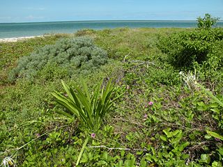
Bundala National Park is an internationally important wintering ground for migratory water birds in Sri Lanka. Bundala harbors 197 species of birds, the highlight being the greater flamingo, which migrate in large flocks. Bundala was designated a wildlife sanctuary in 1969 and redesignated to a national park on 4 January 1993. In 1991 Bundala became the first wetland to be declared as a Ramsar site in Sri Lanka. In 2005 the national park was designated as a biosphere reserve by UNESCO, the fourth biosphere reserve in Sri Lanka. The national park is situated 245 kilometres (152 mi) southeast of Colombo.

<span class="mw-page-title-main">Kumana National Park</span> National park in Sri Lanka

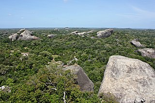
Kumana National Park in Sri Lanka is renowned for its avifauna, particularly its large flocks of migratory waterfowl and wading birds. The park is 391 kilometres (243 mi) southeast of Colombo on Sri Lanka's southeastern coast. Kumana is contiguous with Yala National Park. Kumana was formerly known as Yala East National Park, but changed to its present name on 5 September 2006.

<span class="mw-page-title-main">Big Stone National Wildlife Refuge</span> National wildlife refuge in Minnesota, United States

Straddling the headwaters of the Minnesota River in west-central Minnesota, Big Stone National Wildlife Refuge is within the heart of the tallgrass prairie's historic range. Today, less than one-percent of tallgrass prairie remains.

<span class="mw-page-title-main">Köyceğiz-Dalyan Special Environmental Protection Area</span>

The Köyceğiz-Dalyan Special Environmental Protection Area is a protected natural reserve in the Turkish province of Muğla. In June 1988 it was determined and declared the first protected area of its kind of Turkey. In 1990 the original SPA area was extended westwards. Up to now, there are fourteen natural reserves with this status, of which Pamukkale is probably the best-known. All these areas are under the supervision of the ÖÇKK, the Turkish Environmental Protection Agency for Special Areas.

<span class="mw-page-title-main">Fauna of Louisiana</span> State ecology

The fauna of Louisiana is characterized by the region's low swamplands, bayous, creeks, woodlands, coastal marshlands and beaches, and barrier islands covering an estimated 20,000 square miles, corresponding to 40 percent of Louisiana's total land area. Southern Louisiana contains up to fifty percent of the wetlands found in the Continental United States, and are made up of countless bayous and creeks.

The Kızılırmak Delta is the delta of the Kızılırmak River where it flows into the Black Sea, 40 km east of the city of Samsun. The delta is the third largest in Turkey and has the biggest wetland in Turkey's Black Sea Region. The wetland is a key biodiversity area and one of several internationally important Ramsar sites in Turkey because of its rich bird and plant life. There is a bird reserve which is important for migration.

<span class="mw-page-title-main">Yumurtalık Lagoon</span> Ramsar site

Yumurtalık Lagoon is a lagoon located in Adana Province, southern Turkey. The area is a nature reserve, a national park, and is a Ramsar site.

<span class="mw-page-title-main">Biodiversity of Albania</span>

For a small country, Albania is characterised by a considerable wealth of terrestrial and marine ecosystems and habitats with contrasting floral, faunal, and fungal species, defined in an area of 28,748 square kilometres. Most of the country is predominantly of Mediterranean character, comprehending the country's center and south, while the alpine affinity is more visible in the northeast.

<span class="mw-page-title-main">Albanian Adriatic Sea Coast</span> Albanian coastline of the south-eastern Adriatic Sea

The Albanian Adriatic Sea Coast stretches in the south-eastern Adriatic Sea beginning at the Gulf of Drin in the north, across the port cities of Shëngjin, Durrës, and Vlorë, to the Bay of Vlorë in the south, where the Albanian Riviera as well as the Albanian Ionian Sea Coast begins.

<span class="mw-page-title-main">Buna River-Velipojë Protected Landscape</span> Protected area and a tourist attraction in Albania

The Buna River-Velipojë Protected Landscape is a protected landscape area in northwestern Albania, encompassing the estuary of Drin, the lagoon of Viluni, the river of Buna with its estuary, and the gulf of Drin that runs across the city of Velipojë alongside the Adriatic Sea.

<span class="mw-page-title-main">Wildlife of Greece</span> Flora and fauna of Greece

The wildlife of Greece includes the diverse flora, fauna, and funga of Greece, a country in southern Europe. The country is mostly mountainous with a very long, convoluted coastline, consisting of peninsulas and many islands. The climate ranges from Mediterranean through temperate to alpine, and the habitats include mountains, hills, forests, rivers, lakes, coasts and cultivated land.

References

  1. "Akyatan Lagoon". Ramsar Sites Information Service. Retrieved 25 April 2018.
  2. "Akyatan Lagoon". MPA Global. Archived from the original on 8 February 2017. Retrieved 7 February 2017.
  3. Dr Max Kasparek, Medasset (Green turtle Chelonia mydas In Turkey) (Report to the 24th Meeting of the Standing Committee of the Convention on the Conservation of European Wildlife and Natural Habitats), pp. 6
  4. Kasparek, M., B. J. Godley & A. C. Broderick, 2001. Nesting of the Green Turtle, Chelonia mydas, in the Mediterranean: a review of status and conservation needs. Zoology in the Middle East 24: 45-74
  5. "Marine turtle conservation in Turkey". World Wildlife Foundation.