
Inyo County is a county in the eastern central part of the U.S. state of California, located between the Sierra Nevada and the state of Nevada. In the 2020 census, the population was 19,016. The county seat is Independence. Inyo County is on the east side of the Sierra Nevada and southeast of Yosemite National Park in Central California. It contains the Owens River Valley; it is flanked to the west by the Sierra Nevada and to the east by the White Mountains and the Inyo Mountains. With an area of 10,192 square miles (26,400 km2), Inyo is the second-largest county by area in California, after San Bernardino County. Almost half of that area is within Death Valley National Park. However, with a population density of 1.8 people per square mile, it also has the second-lowest population density in California, after Alpine County.

Lone Pine is a census-designated place (CDP) in Inyo County, California, United States, located 16 mi (26 km) south-southeast of Independence. The population was 2,035 at the 2010 census, up from 1,655 at the 2000 census. The town is located in the Owens Valley, near the Alabama Hills and Mount Whitney, between the eastern peaks of the Sierra Nevada to the west and the Inyo Mountains to the east. The local hospital, Southern Inyo Hospital, offers standby emergency services. The town is named after a solitary pine tree that once existed at the mouth of Lone Pine Canyon. On March 26, 1872, the very large Lone Pine earthquake destroyed most of the town and killed 27 of its 250 to 300 residents.

Mount Whitney is the highest mountain in the contiguous United States, with an elevation of 14,505 feet (4,421 m). It is in East–Central California, in the Sierra Nevada, on the boundary between California's Inyo and Tulare counties, and 84.6 miles (136.2 km) west-northwest of North America's lowest topographic point, Badwater Basin in Death Valley National Park, at 282 ft (86 m) below sea level. The mountain's west slope is in Sequoia National Park and the summit is the southern terminus of the John Muir Trail, which runs 211.9 mi (341.0 km) from Happy Isles in Yosemite Valley. The eastern slopes are in Inyo National Forest in Inyo County. Mount Whitney is ranked 18th by topographic isolation.

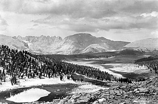
Owens Valley is an arid valley of the Owens River in eastern California in the United States. It is located to the east of the Sierra Nevada, west of the White Mountains and Inyo Mountains, and is split between the Great Basin Desert and the Mojave Desert. The mountain peaks on the West side reach above 14,000 feet (4,300 m) in elevation, while the floor of the Owens Valley is about 4,000 feet (1,200 m), making the valley the deepest in the United States. The Sierra Nevada casts the valley in a rain shadow, which makes Owens Valley "the Land of Little Rain". The bed of Owens Lake, now a predominantly dry endorheic alkali flat, sits on the southern end of the valley.

The 1872 Owens Valley earthquake – also known as the Lone Pine earthquake – struck on March 26 at in the Owens Valley, with the epicenter near the town of Lone Pine. Its magnitude has been estimated at 7.4 to 7.9, with a maximum Mercalli Intensity of X (Extreme). It was one of the most powerful earthquakes to hit California in recorded history and was similar in strength to the 1906 San Francisco earthquake. Twenty-seven people were killed and fifty-six were injured.

Owens Lake is a mostly dry lake in the Owens Valley on the eastern side of the Sierra Nevada in Inyo County, California. It is about 5 miles (8.0 km) south of Lone Pine. Unlike most dry lakes in the Basin and Range Province that have been dry for thousands of years, Owens held significant water until 1913, when much of the Owens River was diverted into the Los Angeles Aqueduct, causing Owens Lake to desiccate by 1926. In 2006, 5% of the water flow was restored. As of 2013, it is the largest single source of dust pollution in the United States.

The Mono–Inyo Craters are a volcanic chain of craters, domes and lava flows in Mono County, Eastern California. The chain stretches 25 miles (40 km) from the northwest shore of Mono Lake to the south of Mammoth Mountain. The Mono Lake Volcanic Field forms the northernmost part of the chain and consists of two volcanic islands in the lake and one cinder cone volcano on its northwest shore. Most of the Mono Craters, which make up the bulk of the northern part of the Mono–Inyo chain, are phreatic volcanoes that have since been either plugged or over-topped by rhyolite domes and lava flows. The Inyo volcanic chain form much of the southern part of the chain and consist of phreatic explosion pits, and rhyolitic lava flows and domes. The southernmost part of the chain consists of fumaroles and explosion pits on Mammoth Mountain and a set of cinder cones south of the mountain; the latter are called the Red Cones.

The John Muir Wilderness is a wilderness area that extends along the crest of the Sierra Nevada of California for 90 miles (140 km), in the Inyo and Sierra National Forests. Established in 1964 by the Wilderness Act and named for naturalist John Muir, it encompasses 652,793 acres (2,641.76 km2). The wilderness lies along the eastern escarpment of the Sierra from near Mammoth Lakes and Devils Postpile National Monument in the north, to Cottonwood Pass near Mount Whitney in the south. The wilderness area also spans the Sierra crest north of Kings Canyon National Park, and extends on the west side of the park down to the Monarch Wilderness.

The Owens River is a river in eastern California in the United States, approximately 183 miles (295 km) long. It drains into and through the Owens Valley, an arid basin between the eastern slope of the Sierra Nevada and the western faces of the Inyo and White Mountains. The river terminates at the endorheic Owens Lake south of Lone Pine, at the bottom of a 2,600 sq mi (6,700 km2) watershed.

The Inyo Mountains are a short mountain range east of the Sierra Nevada in eastern California in the United States. The range separates the Owens Valley to the west from Saline Valley to the east, extending for approximately 70 miles (110 km) south-southeast from the southern end of the White Mountains, from which they are separated by Westgard Pass, to the east of Owens Lake.

Inyo National Forest is a United States National Forest covering parts of the eastern Sierra Nevada of California and the White Mountains of California and Nevada. The forest hosts several superlatives, including Mount Whitney, the highest point in the contiguous United States; Boundary Peak, the highest point in Nevada; and the Ancient Bristlecone Pine Forest, which protects the oldest living trees in the world. The forest, encompassing much of the Owens Valley, was established by Theodore Roosevelt as a way of sectioning off land to accommodate the Los Angeles Aqueduct project in 1907, making the Inyo National Forest one of the least wooded forests in the U.S. National Forest system.
Mount Le Conte is a mountain located in the Sierra Nevada of California. The boundary between Inyo and Tulare counties runs along the crest of the Sierra, across Mount Le Conte. The mountain was named in 1895 for Joseph Le Conte (1823–1901), the first professor of geology and natural history at the University of California.

U.S. Route 395 (US 395) is a United States Numbered Highway, stretching from Hesperia, California to the Canadian border in Laurier, Washington. The California portion of US 395 is a 557-mile (896 km) route which traverses from Interstate 15 (I-15) in Hesperia, north to the Oregon state line in Modoc County near Goose Lake. The route clips into Nevada, serving the cities Carson City and Reno, before returning to California.

The Fossil Falls is a unique geological feature, located in the Coso Range of California in the United States. Volcanic activity in the mountain range, along with meltwater from glaciers in the nearby Sierra Nevada, played a role in the creation of the falls. They are located near the community of Little Lake, 1.0 mi (1.6 km) off US 395 on Cinder Road to Red Hill, with signs to Fossil Falls.
Kearsarge or Kearsarge City is a former mining settlement in Inyo County, eastern California. It was located high on the east slope of the Sierra Nevada, near Kearsage Pass, 8 miles (13 km) west of present-day town of Independence, California.

Kearsarge Peak is a 12,620-foot (3,847 m) mountain located less than two miles east of the crest of the Sierra Nevada mountain range, in Inyo County in northern California. It is situated immediately northwest of Onion Valley in the John Muir Wilderness, on land managed by Inyo National Forest. It is also 8.5 miles (13.7 km) west of the community of Independence, and 2.1 miles (3.4 km) north-northwest of Independence Peak. Topographic relief is significant as the east aspect rises 5,250 feet above Onion Valley in two miles.

Mount Corcoran is a 13,701-foot (4,176 m) mountain summit located on the crest of the Sierra Nevada mountain range in California. It is situated on the boundary between Tulare County and Inyo County, as well as the boundary between Sequoia National Park and John Muir Wilderness. It is 12 miles (19 km) west-southwest of the community of Lone Pine, 3.6 miles (5.8 km) southeast of Mount Whitney, 1.2 miles (1.9 km) northwest of Mount Langley, and 0.23 miles (0.37 km) immediately south of Mount Le Conte, the nearest higher neighbor. Topographic relief is significant as it rises approximately 1,800 feet above Iridescent Lake in one-half mile.

Thor Peak is a 12,306-foot-elevation (3,751-meter) mountain summit located east of the crest of the Sierra Nevada mountain range in Inyo County, California. It is situated in the John Muir Wilderness on land managed by Inyo National Forest. It is 12.5 miles (20.1 km) west of the community of Lone Pine, and 1.5 miles (2.4 km) east of Mount Whitney. Topographic relief is significant as it rises 3,937 feet above Whitney Portal in 1.5 mile. Hikers on the Mount Whitney Trail pass below the impressive south face of the peak.

Cirque Peak is a 12,900-foot-elevation (3,900-meter) mountain summit located on the crest of the Sierra Nevada mountain range in California. It is situated on the common border of Tulare County with Inyo County, as well as the shared boundary of Golden Trout Wilderness and John Muir Wilderness, on land managed by Inyo National Forest. It is 14 miles (23 km) southwest of the community of Lone Pine, 7.7 miles (12.4 km) south-southeast of Mount Whitney, and 3.2 miles (5.1 km) south of Mount Langley, the nearest higher neighbor. Cirque Peak is the highest point of the Golden Trout Wilderness, and ranks as the 175th highest peak in California. Topographic relief is significant as it rises 1,800 feet above Cirque Lake in approximately one mile. The Pacific Crest Trail traverses the southwest slope of this mountain, providing an approach option. The mountain was apparently named in 1890 by Joseph Nisbet LeConte and companions who noted the remarkable cirque on the north aspect.

Mobius Arch is a natural arch in the Alabama Hills range in Inyo County, California. Its name comes from its similarity in appearance to a Möbius strip. The nearest settlement is Lone Pine. It can be accessed through a short loop trail. The arch is a part of the Alabama Hills National Scenic Area and its window is about 6.5 ft (2.0 m) tall. It is a popular subject with photographers and filmmakers due to its framing of Mount Whitney.


