The Crowsnest Highway is an east-west highway in British Columbia and Alberta, Canada. It stretches 1,161 km (721 mi) across the southern portions of both provinces, from Hope, British Columbia to Medicine Hat, Alberta, providing the shortest highway connection between the Lower Mainland and southeast Alberta through the Canadian Rockies. Mostly two-lane, the highway was officially designated in 1932, mainly following a mid-19th-century gold rush trail originally traced out by an engineer named Edgar Dewdney. It takes its name from the Crowsnest Pass, the location at which the highway crosses the Continental Divide between British Columbia and Alberta.

Alberta Provincial Highway No. 2, commonly referred to as Highway 2 or the Queen Elizabeth II Highway, is a major highway in Alberta that stretches from the Canada–United States border through Calgary and Edmonton to Grande Prairie. Running primarily north to south for approximately 1,273 kilometres (791 mi), it is the longest and busiest highway in the province carrying more than 170,000 vehicles per day near Downtown Calgary. The Fort Macleod—Edmonton section forms a portion of the CANAMEX Corridor that links Alaska to Mexico. More than half of Alberta's 4 million residents live in the Calgary–Edmonton Corridor created by Highway 2.

Alberta Provincial Highway No. 3, commonly referred to as Highway 3 and officially named the Crowsnest Highway, is a 324-kilometre (201 mi) highway that traverses southern Alberta, Canada, running from the Crowsnest Pass through Lethbridge to the Trans-Canada Highway in Medicine Hat. Together with British Columbia Highway 3 which begins in Hope, it forms an interprovincial route that serves as an alternate to the Trans-Canada from the Lower Mainland to the Canadian Prairies.
Alberta Provincial Highway No. 16, commonly referred to as Highway 16, is a major east–west highway in central Alberta, Canada, connecting Jasper to Lloydminster via Edmonton. It forms a portion of the Yellowhead Highway, a major interprovincial route of the Trans-Canada Highway system that stretches from Masset, British Columbia to Portage la Prairie, Manitoba, near Winnipeg. Highway 16 spans approximately 634 km (394 mi) from Alberta's border with British Columbia in the west to its border with Saskatchewan in the east. As of 2010, all but less than 96 km (60 mi) of the route was divided, with a minimum of two lanes in each direction. It is designated a core route in Canada's National Highway System.
Alberta Provincial Highway No. 22, commonly referred to as Highway 22 and officially named Cowboy Trail, is a 584-kilometre (363 mi) highway in the Canadian province of Alberta. It generally parallels Highway 2, beginning in the foothills of southern Alberta at Highway 3 near Lundbreck Falls. It proceeds north along the eastern slopes of the Rocky Mountains passing through the foothills and ranch country to the aspen parkland of northern Alberta, ending at Highway 18 near Mayerthorpe.
Alberta Provincial Highway No. 1, commonly referred to as Highway 1, is a major east–west highway in Southern Alberta that forms the southern mainline of the Trans-Canada Highway. It runs from the British Columbia border near Lake Louise through Calgary to the Saskatchewan border east of Medicine Hat. It continues as Highway 1 into both provinces. It spans approximately 534 km (332 mi) from Alberta's border with British Columbia in the west to its border with Saskatchewan in the east. The route is a divided 4-lane expressway throughout the province with the exception of a section in central Calgary where it is an arterial thoroughfare and Urban Boulevard carrying 4 to 6 lanes. The highway is a freeway between the Sunshine exit near the town of Banff and Home Road in Calgary. Other rural sections have at grade intersections with Interchanges only at busier junctions. Twinning of the final 8.5 km (5.3 mi) of Highway 1 between Lake Louise and the British Columbia border was completed by Parks Canada and opened to traffic on June 12, 2014 making the whole length of Alberta Highway 1 a divided minimum 4-lane route.

Alberta Provincial Highway No. 4, commonly referred to as Highway 4, is a 103-kilometre (64 mi) highway in southern Alberta, Canada that connects Highway 3 in Lethbridge to Interstate 15 in Montana. The highway was designated in 1999 as the First Special Service Force Memorial Highway in honour of elite soldiers who travelled to Helena, Montana for training before World War II. The highway continues into the United States retaining that name.

Anthony Henday Drive (Highway 216) is a 78-kilometre (48 mi) freeway that encircles Edmonton, Alberta. It is a heavily travelled commuter and truck bypass route with the southwest quadrant serving as a portion of the CANAMEX Corridor that links Canada to the United States and Mexico. Henday is one of the busiest highways in Western Canada, carrying over 108,000 vehicles per day in 2019 at its busiest point near West Edmonton Mall. Rush hour congestion is common on the four-lane section in southwest Edmonton, where traffic levels have risen due to rapid suburban development. Work began in fall 2019 to widen this section to six lanes by the end of 2022.

Alberta Provincial Highway No. 21, commonly referred to as Highway 21, is a north-south highway in Alberta, Canada that parallels Highway 2 between Calgary and Edmonton. It is approximately 328 kilometres (204 mi) in length. It begins at the Trans-Canada Highway (Highway 1) east of Strathmore, and ends at Fort Saskatchewan where it is succeeded by Highway 15. The northernmost 25 kilometres (16 mi) of the highway are twinned. Highway 21 runs roughly parallel to the main north-south CN rail line between Calgary and Edmonton between Three Hills and Looma.

Alberta Provincial Highway No. 15, commonly referred to as Highway 15 or Manning Drive, is a highway in the Edmonton Region of Alberta, connecting northeast Edmonton to the City of Fort Saskatchewan and communities within Lamont County. It serves as an alternative to Highway 16 that bypasses Elk Island National Park. The highway follows the route of a railway line completed in 1905 by the Canadian Northern Railway. In Edmonton, the most southerly portion of the route is named Fort Road, followed by Manning Drive to the north, a developing freeway.

Highway 17 is a highway in Canada that straddles and criss-crosses the Alberta–Saskatchewan provincial border. The portion from the provincial border at Dillberry Lake Provincial Park to the provincial border 800 metres (2,600 ft) north of the North Saskatchewan River is designated as Alberta Provincial Highway No. 17 by Alberta Transportation, commonly referred to as Highway 17.

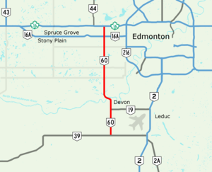
Highway 19 and Highway 625 are two provincial highways south of Edmonton in the Canadian province of Alberta that form a continuous east–west route connecting Highway 60 near Devon to Highway 21 east of Beaumont. Highway 19 was acquired by the City of Edmonton in the land annexation approved by the Province in 2019. Highway 19 passes north of the Edmonton International Airport and, in tandem with Highway 60, provides a southwest bypass of Edmonton between Highways 2 and 16. East of Highway 2, Highway 19 becomes Highway 625 and continues through Nisku Industrial Park. It intersects Highway 814 in before ending at Highway 21.

Alberta Provincial Highway No. 28, commonly referred to as Highway 28, is a highway in north-central Alberta, Canada that connects Edmonton to Cold Lake. It begins at Yellowhead Trail (Highway 16) in Edmonton as 97 Street NW, running through the city's north suburbs before entering Sturgeon County and passing CFB Edmonton. After merging with Highway 28A near Gibbons it winds through agricultural lands of north-central Alberta, roughly paralleling the North Saskatchewan River until Smoky Lake before continuing east through St. Paul County to Bonnyville. It turns northeast to CFB Cold Lake, before ending at Lakeshore Drive in the city of Cold Lake shortly thereafter.
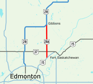
Alberta Provincial Highway No. 28A, commonly referred to as Highway 28A, is an 18-kilometre (11 mi) highway in Alberta, Canada that connects Highway 15 in northeast Edmonton to Highway 28 near Gibbons. It is numbered 17 Street NE within Edmonton and forms an alternate route to Highway 28 into the city from the north. As the southernmost component of the Edmonton–Fort McMurray corridor, the highway is designated as a core route of Canada's National Highway System for its entire length.
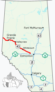
Alberta Provincial Highway No. 43, commonly referred to as Highway 43, is a major highway in northern and central Alberta, Canada that connects Edmonton to the British Columbia border via the Peace Country, forming the northernmost portion of the CANAMEX Corridor in Alberta. It stretches approximately 495 km (308 mi) from Highway 16 near Manly Corner west of Edmonton to the British Columbia border west of Demmitt. It is designated as a core route in Canada's National Highway System, comprising a portion of a key international corridor that stretches from Alaska into Mexico.

Alberta Provincial Highway No. 63, commonly referred to as Highway 63, is a 434-kilometre (270 mi) highway in northern Alberta, Canada that connects the Athabasca oil sands and Fort McMurray to Edmonton via Highway 28. It begins as a two-lane road near the hamlet of Radway where it splits from Highway 28, running north through aspen parkland and farmland of north central Alberta. North of Boyle, it curves east to pass through the hamlet of Grassland and becomes divided west of Atmore where it again turns north, this time through heavy boreal forest and muskeg, particularly beyond Wandering River. Traffic levels significantly increase as Highway 63 bends through Fort McMurray, crossing the Athabasca River before connecting the city to the Syncrude and Suncor Energy plants further north. It ends approximately 16 km (10 mi) beyond a second crossing of the Athabasca River northeast of Fort McKay.

Sherwood Park Freeway is a 7.1-kilometre (4.4 mi) freeway that connects east Edmonton to Sherwood Park in Alberta, Canada. It begins in the Gainer Industrial area where Argyll Road and 82 (Whyte) Avenue merge before intersecting 50 Street. It then curves slightly northeast through industrial areas in southeast Edmonton across 34 Street into Strathcona County, then across 17 Street after which the freeway ends at Anthony Henday Drive. It then continues into Sherwood Park as Wye Road (Highway 630). It is primarily a commuter route, with heavier weekday volume westbound in the morning and eastbound in the afternoon as residents of Sherwood Park commute to Edmonton.

Alberta Provincial Highway No. 16A, commonly referred to as Highway 16A, is the designation of three alternate routes off Alberta Highway 16 in Alberta, Canada. The Evansburg – Entwistle section is called 16A:08 by Alberta Transportation, while 16A:24 runs through Vegreville. The section west of Edmonton is labelled 16A:14 and 16A:16 on Alberta Transportation maps, but is better known as Parkland Highway and Stony Plain Road.
Alberta Provincial Highway No. 16X, commonly referred to as Highway 16X, is the designation of one former and three proposed routes off Highway 16 in Alberta, Canada. The former section was a 36 km (22 mi) east–west provincial highway in Edmonton Capital Region, that existed for approximately 20 years between the 1970s and 1997 and is now part of Highway 16. Right of way is set aside around Hinton, Edson, and Lloydminster that is presently designated as Highway 16X.
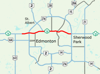
Yellowhead Trail is a 24.6-kilometre (15.3 mi) expressway segment of the Yellowhead Highway in northern Edmonton, Alberta, Canada. It carries a significant amount of truck traffic to and from the industrial areas of north Edmonton and serves as a key commuter route for the bedroom communities of Stony Plain, Spruce Grove, and Sherwood Park, carrying nearly 80,000 vehicles per weekday in 2015. A suburban bypass of the route was completed when the northeast leg of Anthony Henday Drive (Highway 216) opened in late 2016, providing an alternate route through north Edmonton.