
The Monongahela River, sometimes referred to locally as the Mon, is a 130-mile-long (210 km) river on the Allegheny Plateau in north-central West Virginia and Southwestern Pennsylvania. The river flows from the confluence of its west and east forks in north-central West Virginia northeasterly into southwestern Pennsylvania, then northerly to Pittsburgh and its confluence with the Allegheny River to form the Ohio River. The river includes a series of locks and dams that makes it navigable.

Bonneville Lock and Dam consists of several run-of-the-river dam structures that together complete a span of the Columbia River between the U.S. states of Oregon and Washington at River Mile 146.1. The dam is located 40 miles (64 km) east of Portland, Oregon, in the Columbia River Gorge. The primary functions of Bonneville Lock and Dam are electrical power generation and river navigation. The dam was built and is managed by the United States Army Corps of Engineers. At the time of its construction in the 1930s it was the largest water impoundment project of its type in the nation, able to withstand flooding on an unprecedented scale. Electrical power generated at Bonneville is distributed by the Bonneville Power Administration. Bonneville Lock and Dam is named for Army Capt. Benjamin Bonneville, an early explorer credited with charting much of the Oregon Trail. The Bonneville Dam Historic District was designated a National Historic Landmark District in 1987.
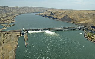
McNary Dam is a 1.4-mile (2.2-km) long concrete gravity run-of-the-river dam which spans the Columbia River. It joins Umatilla County, Oregon with Benton County, Washington, 292 miles (470 km) upriver from the mouth of the Columbia. It is operated by the U.S. Army Corps of Engineers' McNary Lock and Dam office. The dam is located a mile (2 km) east of the town of Umatilla, Oregon, and 8 miles (13 km) north of Hermiston, Oregon. The dam was originally planned to be named Umatilla Dam, but the Flood Control Act of 1945 renamed the dam in honor of Senator Charles L. McNary of Oregon, who had died the previous year.

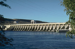
The Dalles Dam is a concrete-gravity run-of-the-river dam spanning the Columbia River, two miles (3 km) east of the city of The Dalles, Oregon, United States. It joins Wasco County, Oregon with Klickitat County, Washington, 300 miles (309 km) upriver from the mouth of the Columbia near Astoria, Oregon. The closest towns on the Washington side are Dallesport and Wishram.
The John Day Dam is a concrete gravity run-of-the-river dam spanning the Columbia River in the northwestern United States. The dam features a navigation lock plus fish ladders on both sides. The John Day Lock has the highest lift of any U.S. lock. The reservoir impounded by the dam is Lake Umatilla, and it runs 76.4 miles (123.0 km) up the river channel to the foot of the McNary Dam. John Day Dam is part of the Columbia River Basin system of dams.

The McAlpine Locks and Dam are a set of locks and a hydroelectric dam at the Falls of the Ohio River at Louisville, Kentucky. They are located at mile point 606.8, and control a 72.9 miles (117.3 km) long navigation pool. The locks and their associated canal were the first major engineering project on the Ohio River, completed in 1830 as the Louisville and Portland Canal, designed to allow shipping traffic to navigate through the Falls of the Ohio.

Wheeler Dam is a hydroelectric dam on the Tennessee River between Lauderdale County and Lawrence County in Alabama. It is one of nine dams on the river owned and operated by the Tennessee Valley Authority, which built the dam in the mid-1930s as part of a New Deal-era initiative to improve navigation on the river and bring flood control and economic development to the region. The dam impounds the Wheeler Lake of 67,070 acres (27,140 ha) and its tailwaters feed into Wilson Lake.

The Lehigh Canal is a navigable canal that begins at the mouth of Nesquehoning Creek on the Lehigh River in eastern Pennsylvania. It was built in two sections over a span of 20 years beginning in 1818. The lower section spanned the distance between Easton and present-day Jim Thorpe. In Easton, the canal met the Delaware and Morris Canals, which allowed anthracite coal and other goods to be transported further up the U.S. East Coast. At its height, the Lehigh Canal was 72 miles (116 km) long.

A river mile is a measure of distance in miles along a river from its mouth. River mile numbers begin at zero and increase further upstream. The corresponding metric unit using kilometers is the river kilometer. They are analogous to vehicle roadway mile markers, except that river miles are rarely marked on the physical river; instead they are marked on navigation charts, and topographic maps. Riverfront properties are sometimes partially legally described by their river mile.

New Savannah Bluff Lock and Dam is a dam with inactive lock at the site of the dead town of New Savannah, Georgia on the Savannah River south of Augusta, Georgia.

The Allegheny River Lock and Dam No. 2 in Pittsburgh, Pennsylvania is a lock and fixed-crest dam from 1932. It crosses the Allegheny River between the Pittsburgh neighborhood of Highland Park and the suburb of Aspinwall. The lock and dam were built by the U.S. Army Corps of Engineers as a part of an extensive system of locks and dams to improve navigation along the Allegheny River. It is the most-used lock operated by the United States Army Corps of Engineers.
C.W. Bill Young Lock and Dam in Harmar Township, Allegheny County, Pennsylvania, and Plum, Pennsylvania, is a lock that was built in 1932. The lock and fixed-crest dam were built by the U.S. Army Corps of Engineers as a part of an extensive system of locks and dams to improve navigation along the Allegheny River.

The Davis Island Lock and Dam Site on the Ohio river in Avalon, Pennsylvania, is the site of the former Davis Island lock that was completed in 1885.

Allegheny River Lock and Dam No. 5 is a historic lock and fixed-crest dam complex located at Gilpin Township and South Buffalo Township in Armstrong County, Pennsylvania. It was built between 1920 and 1927 by the United States Army Corps of Engineers, and consists of the lock, dam, esplanade, and Operations Building. The lock measures 56 feet by 360 feet, and has a lift of 11.6 feet. The dam measures approximately 22 feet high and 632 feet long.
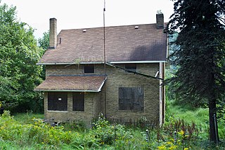
Allegheny River Lock and Dam No. 6 is a historic lock and fixed-crest dam complex located at Bethel Township and South Buffalo Township in Armstrong County, Pennsylvania. It was built between 1927 and 1928 by the United States Army Corps of Engineers, and consists of the lock, dam, esplanade, Operations Building, and two locktenders' houses. The lock measures 56 feet by 360 feet, and has a lift of 12.4 feet. The dam measures approximately 20 feet high and 992 feet long. The Operations Building, or powerhouse, is a utilitarian two-story building in a vernacular early-20th century revival style. The locktenders' houses are identical two-story, brick dwellings on concrete foundations. The lock and dam were built by the U.S. Army Corps of Engineers as a part of an extensive system of locks and dams to improve navigation along the Allegheny River.
Allegheny River Lock and Dam No. 7 is a historic lock and fixed-crest dam complex located at East Franklin Township, Pennsylvania and Kittanning in Armstrong County, Pennsylvania. It was built between 1928 and 1930 by the United States Army Corps of Engineers, and consists of the lock, dam, esplanade, and Operations Building. The lock measures 56 feet by 360 feet, and has a lift of 13.0 feet. The dam measures approximately 20 feet high and 916 feet long. The Operations Building, or powerhouse, is a utilitarian two-story building in a vernacular early-20th century revival style. The lock and dam were built by the U.S. Army Corps of Engineers as a part of an extensive system of locks and dams to improve navigation along the Allegheny River.

Allegheny River Lock and Dam No. 8 is a historic lock and fixed-crest dam complex located at Boggs Township and Washington Township in Armstrong County, Pennsylvania. It was built between 1929 and 1931 by the United States Army Corps of Engineers, and consists of the lock, dam, esplanade, and Operations Building. The lock measures 56 feet by 360 feet, and has a lift of 17.8 feet. The dam measures approximately 50 feet high and 916 feet long; a three-foot addition was built on top of the dam in 1937. The Operations Building, or powerhouse, is a utilitarian two-story building in a vernacular early-20th century revival style. The lock and dam were built by the U.S. Army Corps of Engineers as a part of an extensive system of locks and dams to improve navigation along the Allegheny River.

Allegheny River Lock and Dam No. 9 is a historic lock and fixed-crest dam complex located at Madison Township and Washington Township in Armstrong County, Pennsylvania. It was built between 1935 and 1938 by the United States Army Corps of Engineers, and includes the lock, dam, steel miter gates, and Operations Building. The lock measures 56 feet by 360 feet, and has a lift of 22 feet. The dam measures approximately 60 feet high and 918 feet long. The Operations Building, or powerhouse, is a utilitarian two-story building in a vernacular early-20th century revival style. The lock and dam were built by the U.S. Army Corps of Engineers as a part of an extensive system of locks and dams to improve navigation along the Allegheny River.

The Yamhill River lock and dam was completed in 1900. It was built near Lafayette, Oregon, to allow better river transport on the Yamhill River from Dayton, to McMinnville, Oregon. While the Corps of Engineers had recommended against construction of the lock, it was built anyway, largely as a result of political effort by the backers of the project. For almost forty years prior to the lock construction there had been efforts made to construct a lock and dam on the Yamhill River.


