Sites
| [3] | Landmark name | Image | Location | County | Comments |
|---|---|---|---|---|---|
| 1 | Allegheny Aqueduct [4] |  | Robeson Township: Pennsylvania Route 724 and Allegheny Creek at Gibraltar 40°17′10″N75°53′13″W / 40.28611°N 75.88694°W | Berks | A section of the Schuylkill Canal |
| 2 | Alliance Furnace [5] | 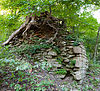 | Perry Township: off Township 568 at Jacob's Creek, northeast of Perryopolis 40°6′45″N79°43′3″W / 40.11250°N 79.71750°W | Fayette | Remnants of a blast furnace complex |
| 3 | Barree Forge and Furnace [6] |  | Porter Township: 2 miles (3.2 km) north of Alexandria along the Juniata River 40°35′18″N78°6′4″W / 40.58833°N 78.10111°W | Huntingdon | Remnants of a blast furnace complex |
| 4 | Beaver Historic District [7] | 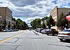 | Beaver: roughly bounded by the Cumberland and Pennsylvania Railroad tracks, Fair Ave., 5th St., 3rd St., and Sassafras Ln. 40°41′41″N80°18′27″W / 40.69472°N 80.30750°W | Beaver | Includes the site of Fort McIntosh |
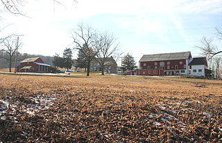
| 5 | Boswell Historic District [8] |  | Boswell: roughly bounded by Hower Ave., Atkinson Way, Quemahoning Creek, Main St., and Juniata St. | Somerset | Coal mining company town |
| 6 | Bradys Bend Iron Company Furnaces [9] |  | Bradys Bend Township: Pennsylvania Route 68 in Bradys Bend 40°59′55″N79°37′34″W / 40.99861°N 79.62611°W | Armstrong | Remnants of a blast furnace complex |
| 7 | George Brinton House [10] |  | Birmingham Township: Pennsylvania Route 100, 1 mile north of its junction with U.S. Route 1, near Chadds Ford 39°52′51″N75°35′56″W / 39.88083°N 75.59889°W | Chester | Includes artifacts of the Battle of Brandywine |
| 8 | John Brown Tannery Site [11] |  | Richmond Township: 500 feet south of the junction of Pennsylvania Route 77 and Lyons Rd. at New Richmond 41°43′8.5″N79°57′3″W / 41.719028°N 79.95083°W | Crawford | Ruins of a tannery operated by abolitionist John Brown |
| 9 | Brown-Moore Blacksmith Shop [12] |  | Luzerne Township: 0.1 miles (0.16 km) west of Pennsylvania Route 4020 39°58′23″N79°53′55″W / 39.97306°N 79.89861°W | Fayette | Well-preserved early nineteenth-century blacksmith shop |
| 10 | Jeremiah Burns Farm [13] | 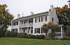 | Washington Township: 10988 Fish and Game Rd. 39°45′58.464″N77°31′47.46″W / 39.76624000°N 77.5298500°W | Franklin | Includes an early sawmill and log cabin site |
| 11 | Cairnbrook Historic District [14] |  | Shade Township: roughly bounded by the Penn Central railroad tracks, McGregor Ave., Windber Ave., and John St. 40°7′20″N78°48′59″W / 40.12222°N 78.81639°W | Somerset | Coal mining company town |
| 12 | Chad House [15] |  | Chadds Ford Township: Pennsylvania Route 100 39°52′29″N75°35′31″W / 39.87472°N 75.59194°W | Delaware | Includes artifacts of the Battle of Brandywine |
| 13 | Chester Creek Historic District [16] |  | Thornbury Township: north, east, and south of Glen Mills along the western branch of Chester Creek 39°55′23″N75°29′27″W / 39.92306°N 75.49083°W | Delaware | Includes multiple early industrial sites |
| 14 | Chickies Historic District [17] |  | East Donegal and West Hempfield Townships: roughly bounded by the Susquehanna River, Chickies Creek, Bank Street, and Long Lane, near Marietta | Lancaster | Includes an early mill site |
| 15 | Codorus Forge and Furnace Historic District [18] |  | Hellam Township: junction of River Farm and Furnace Rds., southeast of Saginaw 40°3′5″N76°39′26″W / 40.05139°N 76.65722°W | York | Remnants of a blast furnace complex |
| 16 | Crosley-Garrett Mill Workers' Housing, Store and Mill Site [19] | 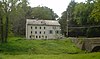 | Newtown Township: Paper Mill Rd. and St. David's Rd. 40°1′9″N75°24′16″W / 40.01917°N 75.40444°W | Delaware | Industrial company town |
| 17 | Dale Furnace and Forge Historic District [20] |  | Washington Township: Forgedale Rd. northwest of Bally 40°25′21″N75°37′1″W / 40.42250°N 75.61694°W | Berks | Remnants of a blast furnace complex |
| 18 | Dreibelbis Mill [21] |  | Perry Township: junction of Dreibelbis Mill and Bellevue Rds. 40°30′22″N75°57′23″W / 40.50611°N 75.95639°W | Berks | Nineteenth-century gristmill |
| 19 | Dykeman's Spring [22] |  | Shippensburg: Dykeman Rd., 0.25 miles (0.40 km) east of Pennsylvania Route 696 40°2′33″N77°30′57″W / 40.04250°N 77.51583°W | Cumberland | Includes military artifacts from the Civil War; also includes a Native American site |
| 20 | Etna Furnace [23] |  | Catharine Township: north of Williamsburg — roughly the area south and east of the bend of the Frankstown Branch Juniata River at Mount Etna 40°31′34″N78°11′11″W / 40.52611°N 78.18639°W | Blair | Remnants of a blast furnace complex |
| 21 | Forks of the Ohio [24] |  | Pittsburgh: Point Park 40°26′27″N80°0′37″W / 40.44083°N 80.01028°W | Allegheny | Includes the site of Fort Pitt |
| 22 | Fort Hunter Historic District [25] |  | Susquehanna Township: U.S. Route 22 40°20′29″N76°54′30″W / 40.34139°N 76.90833°W | Dauphin | Includes the site of Fort Hunter, built in the 1750s |
| 23 | Fort McIntosh Site [26] | 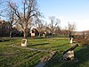 | Beaver: on a bluff overlooking the Ohio River, along River Rd. between College and Dravo Aves. 40°41′27.35″N80°18′14.75″W / 40.6909306°N 80.3040972°W | Beaver | Site of the first U.S. Army fort north of the Ohio River |
| 24 | Gettysburg National Military Park [27] |  | Cumberland, Highland, and Straban Townships: Gettysburg National Military Park, near Gettysburg 39°48′43″N77°14′39″W / 39.81194°N 77.24417°W | Adams | Site of the Battle of Gettysburg |
| 25 | Geiger Mill [28] |  | Robeson Township: junction of Mill Rd. and Pennsylvania Route 82 in Geiger 40°12′0″N75°50′15″W / 40.20000°N 75.83750°W | Berks | Late eighteenth-century gristmill |
| 26 | Greenwood Furnace [29] | 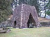 | Jackson Township: Pennsylvania Route 305 in Greenwood Furnace State Park, east of McAlevys Fort 40°38′48″N77°46′41″W / 40.64667°N 77.77806°W | Huntingdon | Remnants of a blast furnace complex |
| 27 | Guldin Mill [30] |  | Maidencreek Township: off Pennsylvania Route 73 southeast of its junction with U.S. Route 222 40°26′8″N75°52′42″W / 40.43556°N 75.87833°W | Berks | Early nineteenth-century gristmill |
| 28 | Holicong Village Historic District [31] | 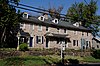 | Buckingham Township: U.S. Route 202 and Holicong Rd. at Holicong 40°20′9″N75°2′55″W / 40.33583°N 75.04861°W | Bucks | Eighteenth-century village |
| 29 | Hower-Slote House [32] |  | Lewis Township: west of Turbotville 41°6′6″N76°47′45″W / 41.10167°N 76.79583°W | Northumberland | Includes part of the site of Fort Freeland, built during the American Revolutionary War |
| 30 | Independence National Historical Park [33] | 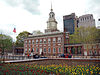 | Philadelphia: bounded by Walnut, 6th, Chestnut, and 2nd Sts. 39°56′52″N75°8′53″W / 39.94778°N 75.14806°W | Philadelphia | Includes Independence Hall |
| 31 | Irwintown Site [34] |  | Spring Creek Township: northern bank of the Allegheny River, above Hallton 41°24′3″N78°54′23″W / 41.40083°N 78.90639°W | Elk | Remains of a nineteenth-century logging town |
| 32 | Jacobsburg Historic District [35] |  | Bushkill Township: 3 miles (4.8 km) northeast of Nazareth off Pennsylvania Route 115 40°46′57″N75°17′34″W / 40.78250°N 75.29278°W | Northampton | Eighteenth-century industrial village |
| 33 | Nicholas Johnson Mill [36] |  | Colebrookdale Township: Mill Crest Rd. 40°20′58″N75°37′12″W / 40.34944°N 75.62000°W | Berks | Nineteenth-century gristmill |
| 34 | Kauffman Mill [37] |  | Upper Bern Township: junction of Mill and Mill Hill Rds. 40°31′30″N76°3′47″W / 40.52500°N 76.06306°W | Berks | Late eighteenth-century gristmill |
| 35 | Kise Mill Bridge Historic District [38] |  | Newberry Township: junction of Kise Mill and Roxberry Rds., east of Lewisberry 40°6′59.5″N76°48′35.9″W / 40.116528°N 76.809972°W | York | Remnants of an early nineteenth-century industrial complex |
| 36 | Knabb-Bieber Mill [39] |  | Oley Township: Bieber Mill Rd. at Monocacy Creek 40°21′33″N75°48′38″W / 40.35917°N 75.81056°W | Berks | Early nineteenth-century gristmill |
| 37 | Knipe-Johnson Farm [40] |  | Upper Gwynedd Township: 606 DeKalb Pike 40°13′2″N75°15′4″W / 40.21722°N 75.25111°W | Montgomery | Includes sites of late eighteenth-century agricultural buildings |
| 38 | Lehigh Canal: Eastern Section Glendon and Abbott Street Industrial Sites [41] |  | Easton: Lehigh River from Hopeville to its confluence with the Delaware River, west of 40°39′24″N75°17′41″W / 40.65667°N 75.29472°W | Northampton | A section of the Lehigh Canal |
| 39 | Legionville [42] |  | Harmony Township: between the Ohio River and Duss Ave., north of its intersection with Legionville Rd. and south of its intersection with Anthony Wayne Dr. 40°37′16″N80°13′42″W / 40.62111°N 80.22833°W | Beaver | Site of the first official U.S. Army training camp |
| 40 | Locust Grove [43] |  | Conoy Township: south of Bainbridge off Pennsylvania Route 441 40°4′44″N76°39′38″W / 40.07889°N 76.66056°W | Lancaster | Late eighteenth-century farmhouse |
| 41 | Israel and Samuel Lupfer Tannery Site and House [44] | Jackson and Toboyne Townships: Black Hollow Rd. 40°16′54.4″N77°32′1.6″W / 40.281778°N 77.533778°W | Perry | Remnants of a nineteenth-century tannery | |
| 42 | Mill Creek Historic District [45] |  | Lower Merion Township: near and east of Bryn Mawr; also roughly bounded by the Schuylkill River, Mill Creek, and Righter's Mill, Rose Glen, and Monk's Rds. 40°1′32″N75°17′8″W / 40.02556°N 75.28556°W | Montgomery | Includes multiple eighteenth-century industrial complexes |
| 43 | Millmont Farm [46] | Montgomery Township: east of Mercersburg at the junction of Pennsylvania Routes 16 and 416 39°48′16″N77°52′24″W / 39.80444°N 77.87333°W | Franklin | Includes a late eighteenth-century gristmill | |
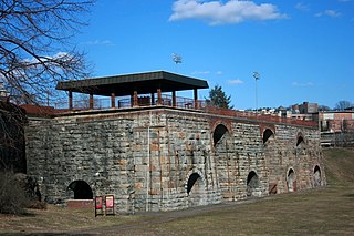
| 44 | Minersville Coke Ovens [47] |  | Carbon Township: Pennsylvania Route 913, 1 mile (1.6 km) east of Coalmont 40°13′0″N78°11′3″W / 40.21667°N 78.18417°W | Huntingdon | A complex of coke ovens |
| 45 | Monroe Furnace [48] |  | Barree Township: junction of Pennsylvania Route 26 and Legislative Route 31076, 6 miles (9.7 km) northwest of McAlevys Fort 40°41′43″N77°53′41″W / 40.69528°N 77.89472°W | Huntingdon | Remnants of a blast furnace complex |
| 46 | Mount Hope Estate [49] |  | Penn and Rapho Townships: northwest of Manheim on Pennsylvania Route 72; also roughly along Shearer's Creek, east of Mansion House Rd. and north of the Pennsylvania Turnpike 40°13′37″N76°25′47″W / 40.22694°N 76.42972°W | Lancaster | Includes remnants of a blast furnace complex |
| 47 | Muddy Creek Forks Historic District [50] |  | East Hopewell, Fawn, and Lower Chanceford Townships: junction of Muddy Creek Forks and New Park Rds. at Muddy Creek Forks 39°48′27″N76°28′31″W / 39.80750°N 76.47528°W | York | Includes the remnants of an eighteenth-century mill complex |
| 48 | Jacob Nicholas House [51] |  | Easton: 458 Ferry St. 40°41′22″N75°12′47″W / 40.68944°N 75.21306°W | Northampton | One of six buildings in Easton built before the American Revolution |
| 49 | North Warwick Historic and Archeological District [52] |  | Warwick Township: Pennsylvania Route 345 and Harmonyville, Bethesda, Hopewell, Piersol, Trythall, and Northside Rds. 40°11′18″N75°46′8″W / 40.18833°N 75.76889°W | Chester | Includes eighteenth- and nineteenth-century industrial complexes; also includes a Native American site |
| 50 | Pennsbury Manor [53] |  | Falls Township: on the Delaware River south of Bordentown Rd. 40°8′0″N74°46′12″W / 40.13333°N 74.77000°W | Bucks | Site of the home of William Penn |
| 51 | Pennsylvania Canal Guard Lock and Feeder Dam, Raystown Branch [54] |  | Henderson Township: 2.5 miles (4.0 km) east of Huntingdon, south of U.S. Route 22 on the Juniata River 40°26′59″N77°58′9″W / 40.44972°N 77.96917°W | Huntingdon | A section of the Pennsylvania Canal |
| 52 | The Printzhof [55] |  | Tinicum Township: Taylor Ave. and 2nd St. in Essington 39°51′40″N75°18′11″W / 39.86111°N 75.30306°W | Delaware | Site of a leading building of New Sweden |
| 53 | Rice's Landing Historic District [56] |  | Rices Landing: roughly bounded by the Monongahela River and Water, 2nd, Bayard, Carmichael, High, Main, and Ferry, including Pumpkin Run Peak 39°56′57″N80°0′0″W / 39.94917°N 80.00000°W | Greene | Includes remains of nineteenth-century industrial buildings |
| 54 | Ridley Creek State Park [57] |  | Edgmont Township: northwest of Media between Pennsylvania Routes 3 and 352 39°57′13″N75°26′41″W / 39.95361°N 75.44472°W | Delaware | Comprises multiple former farms as old as the late seventeenth century |
| 55 | Robertsdale Historic District [58] |  | Wood Township: roughly bounded by the USGS 1840 contour line and S. Main, Wood, Lincoln, Cliff, and Cherry Sts., in Robertsdale 40°11′1″N78°6′45″W / 40.18361°N 78.11250°W | Huntingdon | Coal mining company town |
| 56 | Robesonia Furnace Historic District [59] |  | Robesonia: Furnace, S. Church, and Freeman Sts. and Mountain and E. Meadow Aves. 40°20′34″N76°8′26″W / 40.34278°N 76.14056°W | Berks | Remnants of a blast furnace complex |
| 57 | Rock Hill Farm [60] | Montgomery Township: 12995 and 12755 Bain Rd. near Mercersburg 39°45′7″N77°52′8″W / 39.75194°N 77.86889°W | Franklin | Includes the ruins of an early seventeenth-century outbuilding | |
| 58 | Saltsburg Historic District [61] |  | Saltsburg: roughly west of Plum and Walnut Alleys to the Kiskiminetas River 40°29′2″N79°27′4″W / 40.48389°N 79.45111°W | Indiana | Includes a segment of the Pennsylvania Canal |
| 59 | Shade Furnace Archaeological District [62] |  | Shade Township: north of Rockingham above Dark Shade Creek 40°9′11.22″N78°49′41.88″W / 40.1531167°N 78.8283000°W | Somerset | Remnants of a blast furnace complex |
| 60 | Siegfried's Dale Farm [63] |  | Maxatawny Township: Siegfried's Rd. 40°32′58″N75°43′23″W / 40.54944°N 75.72306°W | Berks | A cluster of eighteenth-century farms |
| 61 | Slickville Historic District [64] |  | Salem Township: roughly bounded by Greenburg and 2nd Aves. and Delmont, Court, Cottage and Fred Sts., in Slickville 40°27′27″N79°31′23″W / 40.45750°N 79.52306°W | Westmoreland | Coal mining company town |
| 62 | Smock Historic District [65] |  | Franklin and Menallen Townships: roughly bounded by Redstone Cemetery, Colonial Mine No. 1, Smock Hill, Colonial Mine No. 2, and Redstone Creek at Smock 39°59′58″N79°47′5″W / 39.99944°N 79.78472°W | Fayette | Coal mining company town |
| 63 | Sommerheim Park Archaeological District [66] |  | Millcreek Township: on bluffs above Sommerheim Dr. and Presque Isle Bay 42°6′49″N80°8′42″W / 42.11361°N 80.14500°W | Erie | Includes a nineteenth-century trash heap, plus multiple Native American sites |
| 64 | Upper Roxborough Historic District [67] |  | Philadelphia and Whitemarsh Township: roughly bounded by Shawmont Ave., Hagy's Mill Rd., and the Schuylkill River 40°3′29″N75°15′6″W / 40.05806°N 75.25167°W | Montgomery, Philadelphia | Includes the remnants of eighteenth-century industrial complexes |
| 65 | Robert Wilson House [68] |  | East Fallowfield Township: Strasburg Rd. near Coatesville 39°57′9″N75°50′32″W / 39.95250°N 75.84222°W | Chester | Includes an early nineteenth-century tannery |
| 66 | Yoder Mill [69] | 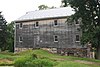 | Pike Township: Yoder Rd. at Oysterville Creek 40°23′48″N75°43′14″W / 40.39667°N 75.72056°W | Berks | Nineteenth-century gristmill |
| 67 | York Iron Company Mine [70] |  | [[ This page is a redirect. The following categories are used to track and monitor this redirect: From a page move: This is a redirect from a page that has been moved (renamed). This page was kept as a redirect to avoid breaking links, both internal and external, that may have been made to the old page name. When appropriate, protection levels are automatically sensed, described and categorized. Categories (++): (+) Navigation menu Ebbedlila Alerts (0) Notices (6) Talk Sandbox Preferences Beta Light mode Watchlist Contributions Log out ArticleTalk Watch More TW Search Search Wikipedia Main page Contents Current events Random article About Wikipedia Contact us Donate Contribute Help Learn to edit Community portal Recent changes Upload file Tools What links here Related changes Special pages Permanent link Page information Cite this page Get shortened URL Print/export Download as PDF Printable version Languages Add links This page was last edited on 18 September 2023, at 10:28. Text is available under the Creative Commons Attribution-ShareAlike License 4.0; additional terms may apply. By using this site, you agree to the Terms of Use and Privacy Policy. Wikipedia® is a registered trademark of the Wikimedia Foundation, Inc., a non-profit organization. Privacy policyAbout WikipediaDisclaimersContact WikipediaCode of ConductDevelopersStatisticsCookie statementMobile viewWikimedia FoundationPowered by MediaWiki North Codorus Township is a township in York County, Pennsylvania, United States. The population was 9,149 at the 202|North Codorus Township]]: north of Green Valley Rd., south of Spring Grove | York | Remnants of a nineteenth-century iron mine |