
The Alpujarra is a natural and historical region in Andalusia, Spain, on the south slopes of the Sierra Nevada and the adjacent valley. The average elevation is 1,200 metres (4,000 ft) above sea level. It extends over two provinces, Granada and Almería; it is sometimes referred to in the plural as "Las Alpujarras". There are several interpretations of this Arabic-origin name: the most convincing is that it derives from al-basharāt (البَشَرَات), meaning something like "sierra of pastures". The administrative centre is Órgiva.

The Poqueira is a river in La Alpujarra region in the province of Granada, in Spain. It is formed by the confluence of streams that rise near the summit of Mulhacén, the highest peak of the Sierra Nevada mountains. The river cuts through a dramatic gorge, then joins the Río Trevélez shortly before flowing into the Río Guadalfeo.

Bubión is a village in Las Alpujarras region of Granada in Spain. It is located at latitude 36° 57' N, longitude 3° 21' W, at 1,350 metres above sea level. Its postal code is 18412. Together with Capileira and Pampaneira it has become a focus for the tourist trade in La Alpujarra, because of the spectacular location of the three villages on the gorge of the Río Poqueira and below the peaks of the Sierra Nevada. The three villages, with their characteristic Moorish features - narrow, winding streets, flat roofs - have been designated as a Conjunto Histórico Artístico, a region of special artistic and historical importance.
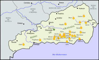
The second rebellion of the Alpujarras, sometimes called the War of the Alpujarras or the Morisco Revolt, was the second such revolt against the Castilian Crown in the mountainous Alpujarra region. The rebels were Moriscos, the nominally Catholic descendants of the Mudéjares following the first rebellion of the Alpujarras (1499–1501).
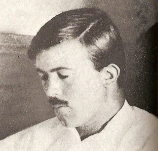
Edward FitzGerald "Gerald" Brenan, CBE, MC was a British writer and hispanist who spent much of his life in Spain.

Capileira is the highest and most northerly of the three villages in the gorge of the Poqueira river in the La Alpujarra district of the province of Granada, in Spain. It is located at latitude 36° 57' N and longitude 3° 21' W, about 1 km north of Bubión. Its altitude is officially recorded as 1436 metres, though there is a considerable altitude difference between the oldest part of the village, which is at the lower, southern end, and the highest part, where tourist-oriented development is currently concentrated. The area of the municipality is 57 km².

The Lecrin Valley is a comarca in the center-south part of the province of Granada, Andalusia, southern Spain. This territory borders the Vega de Granada to the north, the Alpujarra Granadina to the east, the Costa Tropical to the south, and the Alhama to the west.

Al sur de Granada is a 2003 film written and directed by Fernando Colomo, based on the 1957 book by Gerald Brenan. Matthew Goode stars as Brenan, a demobilized soldier who in 1919 rents a house for a year in a village in Alpujarra.

South from Granada: Seven Years in an Andalusian Village is an autobiographical book by Gerald Brenan, first published in 1957.

Almegíjar is a Spanish village and municipality located in the province of Granada, Andalusia. According to the 2005 census (INE), it has a population of 435 inhabitants.
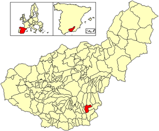
Cádiar is a town located in the province of Granada, Spain. According to the 2005 census (INE), the city has a population of 1601 inhabitants. It borders the municipalities of Lobras, Bérchules, Alpujarra de la Sierra, Ugíjar, Murtas and Albondón. Other nearby towns are Tímar, Golco and Alcútar.

Cástaras is a municipality located in the province of Granada, Spain. According to the 2005 census (INE), the city has a population of 251 inhabitants.

Dúrcal with a population of 7,286 (2012) is a Spanish municipality located in the north-eastern part of the Valle de Lecrín in the Province of Granada, in the autonomous community of Andalusia, one of the 51 entities that make up the metropolitan area of Granada. It borders the municipalities of Dílar, Lanjaron, Nigüelas, Villamena, and the Padul. Other nearby towns are Padul and Mondújar. The council consists of durqueño nuclei Dúrcal, which is the capital district Lecrín Valley, and Marchena. Much of its township is located in the Sierra Nevada National Park.

Pampaneira is a village located in the province of Granada, Spain. According to the 2005 census (INE), the village has a population of 355 inhabitants.

Rubite is a municipality located in the province of Granada, Spain. According to the 2004 census (INE), the village had a population of 492 inhabitants. Rubite is a locality and Spanish municipality situated at the east central of the region "La Costa Granadina" in the province of Granada, independent community of Andalusia. On the shores of the Mediterranean Sea, Rubite is bordered by the municipalities of Lújar, Órgiva and Polopos.

Válor is a municipality located in the province of Granada, Spain. According to the 2005 census (INE), the town (pueblo) has a population of 736 inhabitants.
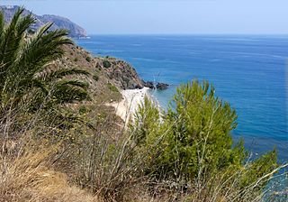
Costa Tropical is a comarca in southern Spain, corresponding to the Mediterranean coastline of the province of Granada, Andalusia. It is also but less frequently called the Costa de Granada or Costa Granadina. It is crossed by the N-340 coastal highway that runs southwest–northeast along Spain's Mediterranean coast, to the border with France. Within the last 4 years the A7 motorway has been extended along the coast from Nerja in the Málaga province to Motril where it links the A7 motorway to the A44 motorway which heads north from Motril to the city of Granada.
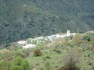
La Taha, is a municipality in the Alpujarras region of the province of Granada, Spain. The modern municipality consists of three distinct villages, though several of these are themselves clusters of distinct settlements. It lies to the east of the villages of the Río Poqueira gorge, and to the south and west of Trevélez. The villages are all on south-facing slopes overlooking the Río Trevélez.
Yegen is a village of the municipality of Alpujarra de la Sierra in the province of Granada.

Sacamantecas or mantequero is the Spanish name for a kind of bogeyman or criminal characterized by killing for human fat.


