Sierra Nevada is a mountain range in the Andalusian province of Granada in Spain. It contains the highest point of continental Spain: Mulhacén, at 3,479 metres (11,414 ft) above sea level.

Álvaro Obregón is a borough in Mexico City. It contains a large portion of the south-west part of Mexico City. It had a 2020 census population of 759,137 inhabitants and lies at an elevation of 2,319 m. above sea level.
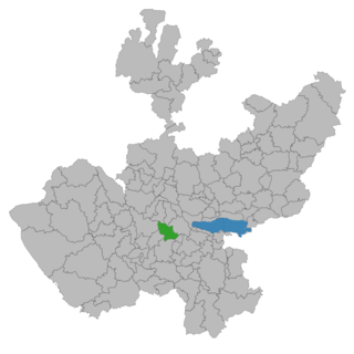
Atemajac de Brizuela is a municipality and small town in the southeast sierra of Jalisco, Mexico, 64 km southwest of Guadalajara, between Highways 80 and 401. The municipality had a population of 6,367 in 2014.

San Bartolomé de Tirajana is a village and a Spanish municipality in the south-eastern part of the island of Gran Canaria in the Las Palmas province in the Canary Islands. With an area of 333.13 km2 (128.62 sq mi), San Bartolomé de Tirajana is the largest municipality in area on the island as well as the Canary Islands. The population is 56,698 (2013).

Silao, officially Silao de la Victoria, is a city in the west-central part of the state of Guanajuato in Mexico. It is the seat of the municipality with the same name. As of the 2005 census, the city had a population of 66,485, making it the seventh-largest city in the state. Silao is a center of agricultural and industrial activity.

Montoro is a municipality of Spain belonging to the province of Córdoba, Andalusia. Housing lies on a bend of the river Guadalquivir, which envelopes from West, North, and East.

Montefrio is a municipality in the province of Granada. The ruins of a Moorish castle sit near the highest point. Being built midway between the Sierra de Priego and Sierra Parapanda, and commanding the open valley between these ranges, it became one of the chief frontier fortresses of the Moors in the 15th century.
San Pedro Lagunillas is both a municipality and the municipal seat of the same in the Mexican state of Nayarit. The population of the municipality was 7,155 (2005) in a total area of 520 square kilometers. The population of the town and municipal seat was 3,630 (2005). The population has been declining since 1980 when it was 8,308 inhabitants.

Iznájar is a town and municipal area in the province of Córdoba in Andalucia, southern Spain.

Socorro is a town and municipality in the Santander Department in northeastern Colombia. It was founded in 1681 by José de Archila and José Díaz Sarmiento. The town was very influential in the history of Colombia. There began the revolt of the Comuneros of 1781 against the oppression of Spanish rule.
Alameda is a town and municipality in the province of Málaga, part of the autonomous community of Andalusia in southern Spain. The municipality is situated approximately 85 km from the city of Málaga. It has a population of approximately 5,000 and the natives are called Alamedanos or Lametanos. It takes its name from the stream Álamos, which crosses the municipality. The Bandito "El Tempranillo" is buried here.

Cuevas de San Marcos is a town and municipality in the province of Málaga, part of the autonomous community of Andalusia in southern Spain. The municipality is situated in the northern part of the Antequera region, on the border of the province of Córdoba from the river valley of Genil to the Sierra Malnombre and Camorro de Cuevas Altas. It is also located within the comarca of Nororma. It borders the provinces of Granada and Cordoba to the north, the comarcas of La Axarquía to the south and Antequera to the west. The town is situated at an altitude of 420 meters above sea level.
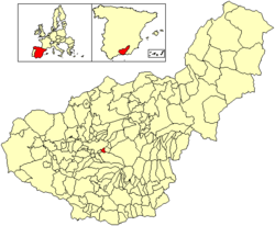
Las Gabias is a Spanish city and municipality located in the central southern part of the Vega of Granada, in the province of Granada, in the autonomous community of Andalusia, approximately 8 km from the provincial capital of Granada. It borders the municipalities of Vegas del Genil, Cúllar Vega, Churriana de la Vega, Alhendín, La Malahá, Chimeneas and Santa Fe. Las Gabias includes the localities of "Gabia Grande", the municipal capital, and "Gabia Chica" that were a unified with the region in 1973, in addition to the annexation of Híjar, Los Llanos, Pedro Verde and San Javier. The name may have originated from Hisn Caviar, which means "military tower", in allusion to the one that still exists in Gabia Grande. It is one of the most populous municipalities in Spain as well as one of the youngest, with the median age of inhabitants being only 34.3 years of age. In 2016, the population of Las Gabias surpassed 20,000, making it the third most populous municipality in the Granada Metropolitan Area, surpassed only by Granada and Armilla.
Retamal de Llerena is a municipality located in the province of Badajoz, Extremadura, Spain. According to the 2008 census (INE), it has a population of 497 people.

Atlacomulco is one of 125 municipalities in the State of Mexico located in the northwest of the State of Mexico in central Mexico, 63 kilometres (39 mi) from the state capital of Toluca. The municipal seat is the city of Atlacomulco de Fabela. The name is derived from the Nahuatl phrase "atlacomulli" which means "where there are wells." The city, with a population of 109,384 is surrounded by rural area in which 75% of the rest of the municipality lives. The municipality has a sizable percentage of indigenous language speakers, mostly Mazahua. The Mazahua name for the area is Embaró, which means "colored rock." Agriculture is still the main economic activity, but the development of a number of industrial parks, such as Atlacomulco 2000, which allowed the seat to reach city statues by 1987. Atlacomulco is also the origin of a political organization called the "Atlacomulco Group" made up of powerful political figures who deny its existence.

The Vega de Granada is a comarca in the province of Granada, southeastern Spain. The name refers to the plain near the city of Granada.

Villa de Álvarez is a municipality in the Mexican state of Colima. The municipal seat lies at Villa de Álvarez.

Monachil is a municipality in the province of Granada, Spain. As of 2018, it has a population of 7,826 inhabitants. It lies around 8 km from the city of Granada. It borders the municipalities of Huétor Vega, Cenes de la Vega, Pinos Genil, Güéjar Sierra, Dílar, La Zubia and Cájar.

Granada is a Spanish Denominación de Origen Protegida (DOP) for wines in the province of Granada, Andalusia, Spain, extending over 168 different municipalities. There is also sub-zone known as "Contraviesa-Alpujarras", covering another 13 municipalities in the Alpujarras mountains. Granada achieved Vino de Calidad status in 2009, and Denominación de Origen status in 2018.
The Cerro Cervantes is a mountain in the Southern Patagonian Ice Field with an elevation of 2,380 meters above sea level or 680 meters above the surrounding terrain. Its foothills are about 5.6 kilometers wide. It is located in Santa Cruz Province, Argentina, and is part of Los Glaciares National Park. Before the 1998 agreement between Argentina and Chile, this mountain was considered a border landmark by Chile.