Faridabad is the most populous city near NCT of Delhi in the Indian state of Haryana and a part of Delhi National Capital Region. It is one of the major satellite cities around Delhi and is located 284 kilometres south of the state capital, Chandigarh. The river Yamuna forms the eastern district boundary with Uttar Pradesh. The Government of India included it in the second list of Smart Cities Mission on 24 May 2016. As per the 2021 Delhi Regional Plan, Faridabad is a part of the Central National Capital Region or Delhi metropolitan area.
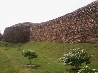
Tughluqabad Fort is a ruined fort in Delhi, India. It was constructed by Ghiyasuddin Tughluq, the founder of the Tughlaq dynasty, of the Delhi Sultanate in 1321 as he established the third historic city of Delhi, but it was later abandoned in 1327. The fort lends its name to the nearby Tughluqabad residential-commercial area as well as the Tughluqabad Institutional Area. Ghiyasuddin Tughluq also built the Qutub-Badarpur Road, which connected the new city to the Grand Trunk Road. The road is now known as Mehrauli-Badarpur Road. The entry fee for the Fort is Rs. 20 for Indians. Also, nearby is Dr. Karni Singh Shooting Range and Okhla Industrial Area.

Lal Kot or Qila Rai Pithora is a fortified complex in present-day Delhi, which includes the Qutb Minar complex. It was constructed in the reign of Tomar Rajput ruler Anangpal Tomar between c. 1052 - c.1060 CE. It is termed as the "First city of Delhi". Remains of the fort walls are scattered across South Delhi, visible in present Saket, Mehrauli around Qutb complex, Sanjay Van, Kishangarh and Vasant Kunj areas.

Gurgaon district, officially known as Gurugram district, is one of the 22 districts of Haryana in northern India. The city of Gurgaon is the administrative headquarters of the district. The population is 1,514,432. It is one of the southern districts of Haryana. On its north, it is bounded by the district of Jhajjar and the Union Territory of Delhi. Faridabad district lies to its east. To its south lie the districts of Palwal and Nuh. To the west lies Rewari district.
Hinduism is the majority religion in Delhi, India. According to the 2011 Census of India, the National Capital Territory of Delhi has 13,712,100 Hindus, who form 81.68% of the population. Hinduism can be extensively seen in culture and history of Delhi and was established by Hindu Tomara king, Anangpala. Though, the Hindus have seen some decline in the Delhi Sultanate and Mughal Empire, due to conversions and persecution. Delhi is also home to many Hindu temple and ashrams. There are more than 590 registered temples in Delhi, out of which Kalka, Birla, Akshardham and ISKCON Temple are the most visited.

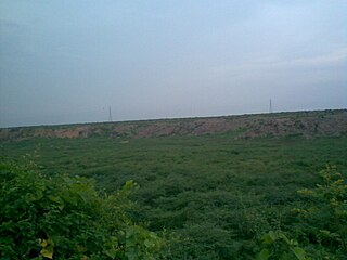
Delhi Ridge, sometimes simply called The Ridge, is a ridge in the Northern Aravalli leopard wildlife corridor in the National Capital Territory of Delhi in India. It is a northern extension of the ancient Aravalli Range, some 1.5 billion years old. The ridge consists of quartzite rocks and extends from the southeast at Tughlaqabad, near the Bhatti mines, branching out in places and tapering off in the north near Wazirabad on the west bank of the river Yamuna, covering about 35 kilometres.
Badkhal Lake is a natural lake situated in Badkhal village near Faridabad, in the Indian state of Haryana, about 32 kilometers from the national capital of Delhi. Fringed by the hills of the Aravalli Range, this was a man-made embankment. Owing to unchecked mining in neighbouring areas, the lake began drying up two decades back and is now totally dried up. There are functional Haryana Tourism Corporation restaurants in the vicinity. A flower show is held every spring here. Its name is most probably derived from the Persian word beydakhal, which means free from interference. Close to Badkhal Lake is the Peacock Lake. It is a biodiversity area within the Northern Aravalli leopard wildlife corridor stretching from Sariska Tiger Reserve to Delhi.

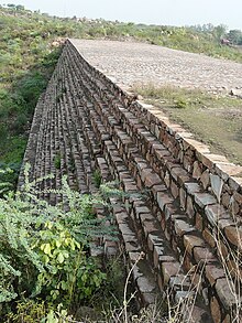
Surajkund is an ancient reservoir of the 10th century located on Southern Delhi Ridge of Aravalli range in Faridabad city of Haryana state about 8 km from South Delhi. Surajkund is an artificial Kund built in the backdrop of the Aravalli hills with an amphitheatre shaped embankment constructed in semicircular form. It is said to have been built by the king Surajpal of the Tomara Rajputs in the 10th century. Tomar, a younger son of Anangpal Tomar – the Rajput ruler of Delhi, was a sun worshipper and he had therefore built a Sun temple on its western bank. Surajkund is known for its annual fair "Surajkund International Craft Mela", 2015 edition of this fair was visited by 1.2 million visitors including 160,000 foreigners with more than 20 countries participating in it.

Chhatarpur Temple is a Hindu temple dedicated to the goddess Katyayani. The entire complex of the temple is spread over a wide area of 28 hectares. It is located in Chhatarpur, on the southwestern outskirts of the New Delhi. It is the 2nd largest temple in Delhi, after the Akshardham Temple. This temple is constructed from marble and on all of the facets there is jaali work. It can be classified a vesara style of architecture.
Ramshah Tomar was the last Tomara king of Gwalior. He was ousted by Akbar and sought refuge at his maternal home in Mewar which at the time was the only state offering resistance to Akbar. Owing to his valour, Udai Singh gave him the title of "Shaho Ka Shah" and also married one of his daughter to Ramshah's son Shalivahan Singh Tomar.
Anangpal II, popularly known as Anangpal Tomar, was an Indian ruler from the Tomara dynasty. He is known to have established and populated Delhi in the 11th century. He is often confused with Anangpal I, the founder of Tomar Dynasty of Delhi, who had reigned during the 8th century. He traced the lineage to Chandravanshi Kshatriya kings, namely Arjuna from the epic Mahabharata.

Asola-Bhati Wildlife Sanctuary covering 32.71 km2 area on the Southern Delhi Ridge of Aravalli hill range on Delhi-Haryana border lies in Southern Delhi as well as northern parts of Faridabad and Gurugram districts of Haryana state. Biodiversity significance of Ridge lies in its merger with Indo-Gangetic plains, as it is the part of the Northern Aravalli leopard wildlife corridor, an important wildlife corridor which starts from the Sariska National Park in Rajasthan, passes through Nuh, Faridabad and Gurugram districts of Haryana and ends at Delhi Ridge.
The Tomaras of Delhi ruled parts of present-day Delhi and Haryana in India during 8th-12th century. Their rule over this region is attested to by multiple inscriptions and coins. In addition, much of the information about them comes from medieval bardic legends. They belonged to the Tomar clan of the Rajputs.

Damdama reservoir in Sohna, near Gurugram city in Gurugram district in the Indian state of Haryana. Damdama Lake is a small lake in Haryana and was formed when a stone and earthen dam constructed by the British was commissioned for rain water harvesting in 1947. The lake, held by an embankment, is fed mainly by monsoon rain pouring into a trough at the base of the Aravali hills. The lake greets visitors with a water level down to 20 ft (6.1 m). During monsoon the water level reaches up to 50 ft (15 m) - 70 ft (21 m).

Asigarh Fort, also called Hansi Fort, is located on the eastern bank of Amti lake in Hansi city of Haryana, India, about 135 km from Delhi on NH9. Spread over 30 acres, in its prime days this fort used to be in control of 80 forts in the area around it. The fort is said to be one of the most impregnable forts of ancient India and has been declared a centrally protected monument by ASI in 1937.
Forests Department, Haryana is a department of the Government of Haryana, a state in India, that runs and maintains many protected nature areas in the state of Haryana. It has two administrative divisions: Forest and Wildlife. The department is responsible for maintaining National Parks, Wildlife Sanctuaries and Conservation Reserves in Haryana. It also provides a special emphasis on Soil and Moisture Conservation works in the hills to conserve water and deliver it to adjacent farmlands. Two National Parks, eight Wildlife Sanctuaries, two Conservation Reserves, four Animal & Bird Breeding Centres, one Deer park, and 49 herbal parks. Kanwar Pal Gujjar has been the cabinet minister responsible for this department since October 2019. constitute the Protected Area network of the department, covering 0.75% of the state. It also maintains a list of Protected Areas in Haryana.

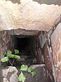
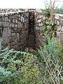
The Baolis of Mehrauli are four stepwells approached through single stage or three stage steps, located in Mehrauli in Delhi, India, in the Mehrauli Archaeological Park mainlined by the Archaeological Survey of India. These are the Anangtal Baoli, the Gandhak Ki Baoli, and the Rajon Ki Baoli. These were built below the ground level as ground water edifices and were built near shrines in medieval times.
Pali is a bhadana's village Pali is an Indian village in the NIT area of Faridabad city of Faridabad district under Faridabad Lok Sabha constituency of Haryana state, well known for being biggest crusher zone of Asia, that also has a seasonal waterfall. It is the part of the Northern Aravalli leopard wildlife corridor, an important wildlife corridor which starts from the Sariska National Park in Rajasthan, passes through Nuh, Faridabad and Gurugram districts of Haryana and ends at Delhi Ridge.
Mangar Bani, a paleolithic archaeological site and sacred grove hill forest next to the Mangar village on Delhi-Haryana border; is in the South Delhi Ridge of Aravalli mountain range in Faridabad tehsil of Faridabad district in the Indian state of Haryana. It lies, immediate south of India's national capital Delhi, within NCR.
Anangpur is a historical village located near Faridabad in Haryana, India. Anangpur forms a geographical triangle along with Mehrauli and Tugluqabad. It was the earliest settlement of the Tomaras. Anangpur was the capital of Anangpal Tomar who had built the fort and monuments here.