Sahibi River

Last updated

Sahibi River
Delhi aerial photo 03-2016 img2.jpg
Location
Country India
Physical characteristics
Source 
  location Aravalli Range, From Jitgarh, Manoharpur, and Saiwar Protected Forest (PF) hills in Sikar District.
Mouth  
  location
Delhi
Length120 km (75 mi)
Discharge 
  location Yamuna in Delhi
Basin features
Tributaries 
  leftNarayanpur Nala, Surakh Nali, Hajipur Nala, Kasoti Nala, Khar Nali
  right Sota river, Kotkasim drain, Krishnavati river and Indori river (Indori Nallah), Dohan River
Waterbodies Masani barrage, Najafgarh Lake
BridgesMasani Bridge on NH-48, Sodawas Bridge on SH-14, Bridge onSH-52, Ajarka Bridge on Rewari-Alwar Railway Line, Pataudi Bridge on Rewari-Delhi Railway Line, Railway Bridge Nangal Pathani.
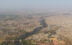
The Sahibi river, also called the Sabi River, is an ephemeral, rain-fed river flowing through Rajasthan, Haryana (where its canalised portion is called the "Outfall Drain No 8") and Delhi states in India. [1] It originates in the eastern slopes of the Saiwar Protected Forest (PF) hills in Sikar District, enters Jaipur district near the foot of these hills, and after initially flowing southeast and east turns northeastwards near Shahpura and continues further till it exits Rajasthan to enter Haryana and further drains into Yamuna in Delhi, where its channeled course is also called the Najafgarh drain, which also serves as Najafgarh drain bird sanctuary. [2] [3] It flows for 300 km of which 157 km is in Rajasthan 100 km is in Haryana and 40 km in Delhi.

Contents

The current and paleochannels of Sahibi river have several important wetlands that lie in series, including the Masani barrage wetland, Matanhail forest, Chhuchhakwas-Godhari, Khaparwas Wildlife Sanctuary, Bhindawas Wildlife Sanctuary, Outfall Drain Number 6 (canalised portion in Haryana of Sahibii river), Outfall Drain Number 8 (canalised portion in Haryana of Dohan river which is a tributary of Sahibi river), Sarbashirpur, Sultanpur National Park, Basai Wetland, Najafgarh lake and Najafgarh drain bird sanctuary, and The Lost lake of Gurugram, all of which are home to endangered and migratory birds, yet largely remain unprotected under extreme threat from the colonisers and builders.

Several Ochre Coloured Pottery culture sites (also identified as late Harappan phase of Indus Valley civilisation culture) [4] have been found along the banks of Sahibi river and its tributaries such as Krishnavati river, Dohan river (originates near Neem Ka Thana in Alwar district) and Sota River (merges with Sahibi river at Behror in Alwar district and its canalised portion in Haryana is called the "Outfall Drain No 6"). [5] The drainage pattern for all these rivers is dendritic.

Geography

The Sahibi River originates from the eastern slopes of the Saiwar Protected Forest hills in Aravalli Range near Jitgarh and Manoharpur in Sikar district of Rajasthan state. After covering about 157 km distance in the Rajasthan state. After gathering volume from a hundred tributaries, the Sahibi River forms a broad stream around Alwar and Kotputli.

Tributaries

These west to north-west flowing rivers originate from the western slopes of Aravalli range in Rajasthan, flow through semi-arid historical Shekhawati region, drain into southern Haryana.

Basin & Catchment area

Sabi River Basin is located in the mid north eastern part of Rajasthan. It stretches between 27° 18' 39.13” to 28° 13' 55.10” North latitude and 76° 58' 21.09’’ to 75° 45' 35.05’’ East longitude. It is bounded in the northwest by Shekhawati River Basin and Ruparail and Banganga River Basins in the southeast. The northern boundary is shared administratively with Haryana State. The Basin extends over parts of Jaipur Rural and Neem Ka Thana, Kot Behror, Khairthal, Rewari, Jhajjar, Gurugram districts. The total catchment area of the Basin is 4607.9 km2.

The catchment area of the Sahibi River encompasses the following cities and towns: Sikar, Jaipur, and Kotputli in northeastern Rajasthan state; Bawal, Rewari, Pataudi, and Jhajjar district in southern Haryana state; and Delhi state.

Rajasthan

The catchment area of the Sahibi River in Rajasthan is 4,523.67 square kilometres (1,746.60 sq mi) of Jaipur, Alwar and Sikar Districts, between latitudes 27°16' and 28°11' and longitudes 75°42' and 76°57'. Sahibi Basin falls in three Districts of Rajasthan namely: Alwar district (62.11%), Jaipur district (29.30%) and Sikar district (8.59%).

Mean Annual Rainfall in Sahibi Basin is 627.60 mm. Highest maximum temperature ranges from 45.45 to 45.99 °C with a mean value of 45.8 °C, while Lowest minimum temperature ranges from 1.64 to 3.14 °C with a mean value of 2.45 °C.

Haryana

It leaves Rajasthan state beyond Kotkasim in Alwar district near village Lalpur and covers a total distance of about 222 km up to Dhasa Bund.

It enters Haryana state at Jhabua, near the city of Rewari in Rewari district, after which it re-enters first Rajasthan state near Kotkasim, and then Haryana again near the village of Jarthal. The dry riverbed near Jarthal is 2 kilometres (1.2 mi) wide. During light monsoon rainfall, the river's flat and sandy bottom absorbs all rainwater. Masani barrage on the river lies near Dahuhera. During heavy rains, the river has defined course up to Pataudi railway station and branches off into two smaller streams to Jhajjar, finally reaching the outskirts of Delhi through Najafgarh drain and ending at the Yamuna River.

Delhi

The Najafgarh Drain or Najafgarh Nallah (nullah in Hindi means drain) is another name for the Sahibi River, which continues its flow through Delhi where it is channelised for flood control purposes. It is a tributary to the Yamuna River, into which it flows. The Najafgarh Drain gets its name from the once famous and huge Najafgarh Lake near the town of Najafgarh in southwest Delhi. The Najafgarh Drain is the capital's most polluted body of water due to the direct inflow of untreated sewage from surrounding populated areas. Assessing the water quality of wetlands in wildlife habitats, a January 2005 report by the Central Pollution Control Board rated the Najafgarh Drain under category D, along with 13 other highly polluted wetlands. [8] [9] [10] [11] [12]

Regulators at the Keshopur Bus Depot on the Outer Ring Road are wide with thick and high embankments. A vast amount of water is retained in this widened drain by closing the Kakrola regulators under Najafgarh Road to recharge the local groundwater table. [13]

Barrages and bridges

Several bridges cross the Sahibi River. A bridge on State Highway 14 crosses the river between Behror and Sodawas (Behror to Alwar Road). On State Highway 52, a bridge crosses the river between Ajaraka and Dadhiya. The Masani barrage is also used as the bridge on NH 919 which merges with NH 48 (Delhi-Jaipur-Mumbai, formerly NH 8) at this barrage near Dharuhera, Rewari. [14] Buchara dam is located in Buchara Leopard Sanctuary Kotputli on Sota River , a major tributary. Railway bridges between Ajaraka and Bawal and near Pataudi also cross the river. A railway bridge near Nangal Pathani also crosses the river.

History

Prior to 1960, the rain-fed Sahibi River entered Delhi near Dhansa and spilled its overflow in the Najafgarh Lake (Jheel) basin, creating a seasonal lake. A vast area more than 300 square kilometres (120 sq mi) was submerged in some seasons. In the following decades, the Sahibi River flow reaching Dhansa was channelised by digging a wide drain and connecting it directly to the Yamuna River, completely draining the seasonal Najafgarh Jheel.

The Sahibi River flooded in 1977. In response, the Masani barrage was constructed on Delhi-Jaipur highway near Masani village, Rewari. [15] [16] Several smaller dams have also been constructed throughout the hills of Rajasthan to store rainwater. The construction of dams has restricted the flow of water on the Sahibi River and it is now rare for water overflow from monsoon rains to reach up the Masani Barrage.

Archaeological sites in the area

Earthenware (Pottery) found on the Sahibi riverbed by INTACH-Rewari, at Hansaka village, Rewari District, 2012 Harrapan period earthen ware from village, Hansaka, Rewari District, Haryana, on the bed of Sahibi River.JPG
Earthenware (Pottery) found on the Sahibi riverbed by INTACH-Rewari, at Hansaka village, Rewari District, 2012

Parts of Rajasthan and Haryana that Sahibi river flows through are arid and have only seasonal monsoon rainfall, in the past river might have held perennial flow as evident by the presence of several sites of the Ganeshwar–Jodhpura culture on the banks of present-day Sahibi River meanders and its tributaries. Among the finds are handmade and wheel-made pottery dated to 3309–2709 BCE and 2879–2384 BCE found on the banks of the Sahibi River at Jodhpura. [17] [18]

Other findings include pottery found on the Sahibi riverbed at Hansaka in the Rewari district by INTACH-Rewari. [17] [18]

A red stone statue of Vamana Dev, now displayed at the Shri Krishna Museum, Kurukshetra was unearthed in 2002 on the Sahibi riverbed near Bawal. [17] [18]

In various other places on Sahibi riverbed, many artifacts have been found, including arrowheads, fishhooks, spearheads, awls, and chisels. [17] [18]

Identification with Vedic rivers

Several modern scholars identify the old Ghaggar-Hakra River (of which Tangri river is a tributary) as the Sarasvati river and the Sahibi River with the Drishadvati river of Vedic period, on the banks of which in the Vedic state of Brahmavarta, Indus-Sarasvati civilisation or Vedic Sanskriti developed. Such scholars include Bhargava [19] The Drishadwati River had formed one border of the Vedic state of Brahmavarta while other was Saraswati river. This is mentioned in the Rigveda , the Manusmriti , and the other Hindu texts as well.

Ecology

This is an important part of ecological corridor along the route of Sahibi river which traverses from Aravalli hills in Rajasthan to Yamuna via Masani barrage, Matanhail forest, Chhuchhakwas-Godhari, Khaparwas Wildlife Sanctuary, Bhindawas Wildlife Sanctuary, Outfall Drain Number 8 and 6, Sarbashirpur, Sultanpur National Park, Basai and The Lost Lake (Gurugram). It lies 5 km northwest of Bhindawas Bird Sanctuary and 46 km northwest of Sultantpur National Park via road.

Ecological concerns

Entire 100 km stretch of Sahibi river and its streams (Sota river, Kotkasim drain and Indori river) in Haryana are ecologically dead. [2] Gurugram also dumps polluted discharge in the riverbed of Sahibi. [2] In some of its reaches, from Mandawar and Kotkasim to Haryana border, meandering of the river causes bank erosion.

Restoration

Government of Haryana is coordinating with Government of Rajasthan to ensure water reaches usually-dry Masani barrage and dying seasonal Sahibi river. Another government project is being implemented to direct the extra water of Yamuna river during monsoon to Masani barrage through Jawahar Lal Nehru Canal and Western Yamuna Canal (c. July 2015). [20]

See also

Related Research Articles

<span class="mw-page-title-main">Sarasvati River</span> River mentioned in the Vedas and ancient Indian epics

The Sarasvati River is a deified mythological river first mentioned in the Rigveda and later in Vedic and post-Vedic texts. It played an important role in the Vedic religion, appearing in all but the fourth book of the Rigveda.

<span class="mw-page-title-main">Aravalli Range</span> Mountain range in western India

The Aravalli Range is a mountain range in Northern-Western India, running approximately 670 km (420 mi) in a south-west direction, starting near Delhi, passing through southern Haryana, Rajasthan, and ending in Ahmedabad Gujarat. The highest peak is Guru Shikhar on Mount Abu at 1,722 m (5,650 ft). The Aravalli Range is arguably the oldest geological feature on Earth, having its origin in the Proterozoic era.

<span class="mw-page-title-main">Chautang</span> River in India

The Chautang is a seasonal river, originating in the Sivalik Hills, in the Indian state of Haryana. The Chautang River is a tributary of the Sarsuti river which in turn is a tributary of the Ghaggar river.

<span class="mw-page-title-main">Ghaggar-Hakra River</span> Intermittent river in India and Pakistan

The Ghaggar-Hakra River is an intermittent river in India and Pakistan that flows only during the monsoon season. The river is known as Ghaggar before the Ottu barrage at 29.4875°N 74.8925°E, and as Hakra downstream of the barrage in the Thar Desert. In pre-Harappan times the Ghaggar was a tributary of the Sutlej. It is still connected to this paleochannel of the Sutlej, and possibly the Yamuna, which ended in the Nara River, presently a delta channel of the Indus River joining the sea via Sir Creek.

<span class="mw-page-title-main">Drishadvati River</span> River

The Drishadvati River is a river hypothesized by Indologists to identify the route of the Vedic river Saraswati and the state of Brahmavarta. According to Manusmriti, the Brahmavarta, where the Rishis composed the Vedas and other Sanskrit texts of the Vedic religion, was at the confluence of the Saraswati and Drishadvati rivers during the Vedic period.

<span class="mw-page-title-main">Behror</span> City in Rajasthan, India

Behror is a city in the Kotpulti-Behror district of Rajasthan of the Jaipur division. It serves as the administrative headquarters of the eponymous Behror Tehsil and shares headquarters for Kotputli-Behror district with Kotputli. It is equidistant from both sate capital Jaipur and national capital New Delhi. Located 120 km south-west of New Delhi and as a part of National Capital Region, it is regulated under National Capital Region Planning Board which is a federal authority for urban planning purposes in NCR. Along with Shahjahanpur and Neemrana it is grouped as SNB Complex (Shahjahanpur-Neemrana-Behror) of NCR- which includes 137 revenue villages, in which Behror municipality is the largest urban conglomeration. This region is also known as 'Ahirwal region' or simply as Raath and is an important industrial hub for the state of Rajasthan. Behror municipality spreads out in an area of 15 km2 is divided into four revenue villages namely Behror tarf Gangabishan, Behror tarf Doongrasi, Behror tarf Nainsukh, Behror tarf Balram.

<span class="mw-page-title-main">Administrative divisions of Haryana</span> Regional divisions in Haryana

Haryana, formed on 1 November 1966, is a state in North India. For the administrative purpose, Haryana is divided into 6 revenue divisions which are further divided into 22 districts. For Law and Order maintenance, it is divided into 5 Police Ranges and 4 Police Commissionerates.

<span class="mw-page-title-main">Najafgarh drain</span> Northernmost end of River Sahibi

The Najafgarh drain or Najafgarh nalah, which also acts as Najafgarh drain bird sanctuary, is another name for the northernmost end of River Sahibi, which continues its flow through Delhi, where it is channelized, and then flows into the Yamuna. Within Delhi, due to its channelization for flood control purposes, it is now erroneously called "Najafgarh drain" or "Najafgarh nullah." It gets this name from the once famous and huge Najafgarh Jheel (lake) near the town of Najafgarh in southwest Delhi and within urbanized Delhi. It is the Indian capital’s most polluted water body due to direct inflow of untreated sewage from surrounding populated areas. A January 2005 report by the Central Pollution Control Board classifies this drain, with 13 other highly polluted wetlands, under category ‘‘D’’ for assessing the water quality of wetlands in wildlife habitats.

Chhawla or Najafgarh drain city forest consists of forestry plantations near the town of Chhawla on both embankments of Najafgarh drain, which is the delhi-end of Sahibi River originating from Aravalli range mountain in Rajasthan, flowing along the border of Haryana state and south west Delhi in India before converging with Yamuna. It provides refuge to local and migratory wildlife specially waterfowl and other water birds. The area is a subset of the entire Najafgarh drain in south west Delhi with forested plantations on both its embankments which has now been proposed as the Najafgarh drain bird sanctuary.

Masani is a village on Sahibi River barrage in Rewari District in the Indian state of Haryana. it is location of lake, eco-tourism, farm tourism and industrial units. It is situated on Rewari-Dharuhera road section of national highway NH 919 that connects Rewari to Sohna and Palwal.

<span class="mw-page-title-main">Bhindawas Wildlife Sanctuary</span> Wildlife Sanctuary in Haryana, India

Bhindawas Wildlife Sanctuary Ramsar site is located in Jhajjar district, which is about 15 km from Jhajjar in Haryana. On 3 June 2009, it is also declared as bird sanctuary by the Indian Government.

Khaparwas Bird Sanctuary is a bird sanctuary in Jhajjar district, about 80 kilometres (50 mi) west of Delhi). The reserve covers 82.70 hectares. This is an important part of ecological corridor along the route of Sahibi River which traverses from Aravalli hills in Rajasthan to Yamuna via Masani barrage, Matanhail forest, Chhuchhakwas-Godhari, Khaparwas Wildlife Sanctuary, Bhindawas Wildlife Sanctuary, Outfall Drain Number 8 and 6, Sarbashirpur, Sultanpur National Park, Basai and The Lost Lake (Gurugram). It lies 5 km northwest of Bhindawas Bird Sanctuary and 46 km northwest of Sultantpur National Park via road.

<span class="mw-page-title-main">Sarsuti</span> River in India

The Sarsuti river, originating in Sivalik Hills and flowing through the palaeochannel of Yamuna, is a tributary of Ghaggar river in of Haryana state of India. Its course is dotted with archaeological and religious sites dating back to post-Harrapan Mahabharata sites from Vedic period, such as Kapal Mochan, Kurukshetra, Thanesar, Brahma Sarovar, Jyotisar, Bhor Saidan and Pehowa.

<span class="mw-page-title-main">Dangri</span> River in India

The Tangri River, also called the Dangri River, which originates in the Shivalik Hills, is a tributary of the Ghaggar River in the Haryana state of India.

The Somb river, also spelled Som river is a tributary of Yamuna in Haryana state of India.

The Indori river, is a rain-fed river originates from Aravalli Range from Sikar district and flows through Alwar district of Rajasthan to Rewari district of Haryana and it is the longest tributary of Sahibi River which stretches to 50 km. In Delhi, it is called the Najafgarh drain or Najafgarh Nallah.

The Krishnavati river, also called Kasaunti, is a rain-fed river originates from Aravalli Range near Dariba copper mines in Rajsamand district of Rajasthan, and flows through Patan in Dausa district and Mothooka in Alwar district and then disappears in Mahendragarh district in Haryana where it use to be a tributary of Sahibi River, which in turn still is a tributary of Yamuna. Several Ochre Coloured Pottery culture sites have been found along the banks of Krishnavati, Sahibi river, Dohan river and Sota River. The drainage pattern for all these rivers is dendritic.

The Dohan river, is a rain-fed river that originates at Mandholi village near Neem Ka Thana in Sikar district of Rajasthan and then disappears in Mahendragarh district in Haryana where it used to be a tributary of Sahibi River, which in turn is a still flowing tributary of Yamuna. Its canalised portion in one of its paleochannel in Haryana is called the "Outfall Drain No 8".

<span class="mw-page-title-main">Masani barrage</span> Dam in Masani in Rewari District

Masani barrage, also Masani bridge, a barrage on the seasonal Sahibi River completed in 1989, is named after the Masani village in Rewari District of Haryana in India. Masani barrage also serves as a bridge on NH 919. Water storage in the barrage was made perennial in 2017 after a gap of 50 years. This barrage is important part of ecological corridor along the route of Sahibi river which traverses from Aravalli hills in Rajasthan to Yamuna via Matanhail forest, Chhuchhakwas-Godhari, Khaparwas Wildlife Sanctuary, Bhindawas Wildlife Sanctuary, Outfall Drain Number 8 and 6, Sarbashirpur, Sultanpur National Park, Basai and The Lost Lake (Gurugram).

<span class="mw-page-title-main">Kotputli-Behror district</span> District in Rajasthan, India

Kotputli-Behror is a district in the state of Rajasthan. This district was carved out from erstwhile Jaipur district and Alwar district and was formally established on 7 August 2023. It is located in north-eastern part of Rajasthan. The districts is surrounded on three sides with Aravali Ranges with Sabi river flowing through it. It comprises Tehsils of Kotpulti, Behror, Neemrana, Bansur, Mandhan, Paota, Viratnagar and Narayanpur. District headquarters are jointly located at Behror and Kotputli. Piyadasi as name of Emperor Ashoka was found out form the Bhabru rock edicts found in the district. A major part of the district comprising Tehsils of Behror, Neemrana, Bansur, Mandhan and is referred to as Rath Region though Mundawar tehsil of Rath region was made part of separate district of Khairthal.

References

  1. 1 2 Books: Page 41, 42, 43, 44, 47 (b) Sahibi Nadi (River), River Pollution, By A.k.jain
  2. 1 2 3 Haryana rivers profile
  3. Ropeway for tourist pull at barrage site, Times of India
  4. Gupta, S.P., ed. (1995), The lost Sarasvati and the Indus Civilization, Jodhpur: Kusumanjali Prakashan
  5. 1 2 Cultural Contours of India: Dr. Satya Prakash Felicitation Volume, Vijai Shankar Śrivastava, 1981. ISBN   0391023586
  6. Sahibi river
  7. Minerals and Metals in Ancient India: Archaeological evidence, Arun Kumar Biswas, Sulekha Biswas, University of Michigan. 1996. ISBN   812460049X.
  8. Blot across the Capital: Najafgarh most polluted [ dead link ], Sunday, 10 July 2005,The Indian Express
  9. minister raises a stink over Najafgarh jheel [ dead link ], 22 February 2005, The Indian Express
  10. Najafgarh basin Delhi's most polluted area, 25 December 2009, The Indian Express
  11. Najafgarh drain 11th among highly polluted industrial clusters, 25 Dec 2009, The Times of India
  12. drain causes less pollution in Yamuna now [ dead link ], 4 July 2006, The Indian Express
  13. to Sahibi River, Department of Irrigation and Flood Control, Government of NCT of Delhi, India. Website Last Updated : 3 May 2010, sewage drain is now called the Yamuna, By Sonu Jain, 27 March 1999, Indian Express, CRUSADE: Killing Delhi's Lifeline Archived 4 January 2013 at archive.today , Charu Soni, 19 Aug 2006, New Delhi. Tehelka,gone all wrong, By Sunita Narain, 5 Jun 2012, Times of India, ‘Better management in Haryana may solve Delhi's water problems’, New Delhi, 22 Mar 2012, DHNS, Deccan herald, Sunita Narain bats for sustainable development, Express News Service : Pune, Tue 28 February 2012, The Indian Express
  14. "Toll plaza on NH 8 to be shifted, says Nitin Gadkari.", Indian Express, 14 August 2017.
  15. Ground Water Information Booklet Rewari District, Haryana, Contributors: Dr. Sunil Kumar, Scientist – ‘B’, Prepared under supervision of Sushil Gupta Regional Director. Our Vision "Water Security through Ground water Management" . Rewari District Haryana, Central Ground Water Board, Ministry of Water Resources, Government of India, North Western Region, CHANDIGARH, 2007
  16. Geography of Haryana Archived 1 February 2016 at the Wayback Machine
  17. 1 2 3 4 A History of Ancient and Early Medieval India from the stone age to the 12th century, Pearson 2009, page 116
  18. 1 2 3 4 India Mapped - Sahibi river
  19. "Location of Brahmavarta and Drishadwati River is important to find earliest alignment of Saraswati River", Sudhir Bhargava, International Conference, 20–22 Nov. 2009, "Saraswati-a perspective" pages 114–117, Kurukshetra University, Kurukshetra, Organised by: Saraswati Nadi Shodh Sansthan, Haryana.
  20. "Centre of AIIMS to come up in Rewari district: Khattar .", Business Standard, 4 July 2015.

28°29′N76°44′E / 28.483°N 76.733°E / 28.483; 76.733