Kaushalya river

Last updated

Kaushalya River
Kaushalya dam, near Pinjor, Haryana, India.JPG
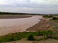
Kaushalya dam near Pinjore
Location
Country India
Physical characteristics
Source 
  location Shivalik Hills, Himachal Pradesh
Mouth  
  location
Panchkula district, Haryana
Length20 km (12 mi)
Discharge 
  location Ghaggar river just south-east of Pinjore
Basin features
Waterbodies Kaushalya Dam
BridgesKaushalya bridge

The Kaushalya river, a tributary of Ghaggar river, is a river in Panchkula district of Haryana state of India. [1]

Contents

Origin and route

The Kaushalya river rises in the Shivalik hills on the border of Haryana and Himachal Pradesh State, and flows through Panchkula district and converges with Ghaggar river near Pinjore just downstream of Kaushalya Dam. [1]

The basin is classified in two parts, Khadir and Bangar, the higher area that is not flooded in rainy season is called Bangar and the lower flood-prone area is called Khadar. [2]

Several archaeologists have identified the old Ghaggar-Hakra River with the Sarasvati river, on the banks of which the Indus Valley civilisation developed. [3] [4] [5] [6]

See also

Related Research Articles

<span class="mw-page-title-main">Sarasvati River</span> River mentioned in the Vedas and ancient Indian epics

The Sarasvati River is a deified river first mentioned in the Rigveda and later in Vedic and post-Vedic texts. It played an important role in the Vedic religion, appearing in all but the fourth book of the Rigveda.

<span class="mw-page-title-main">Sutlej</span> River in Asia

The Sutlej or Satluj River is the longest of the five rivers that flow through the historic crossroads region of Punjab in northern India and Pakistan. The Sutlej River is also known as Satadru. It is the easternmost tributary of the Indus River. The Bhakra Dam is built around the river Sutlej to provide irrigation and other facilities to the states of Punjab, Rajasthan and Haryana.

<span class="mw-page-title-main">Chautang</span> River in India

The Chautang is a seasonal river, originating in the Sivalik Hills, in the Indian state of Haryana. The Chautang River is a tributary of the Sarsuti river which in turn is a tributary of the Ghaggar river.

<span class="mw-page-title-main">Ghaggar-Hakra River</span> Intermittent river in India and Pakistan

The Ghaggar-Hakra River is an intermittent river in India and Pakistan that flows only during the monsoon season. The river is known as Ghaggar before the Ottu barrage, and as Hakra downstream of the barrage in the Thar Desert. In pre-Harappan times the Ghaggar was a tributary of the Sutlej. It is still connected to this paleochannel of the Sutlej, and possibly the Yamuna, which ended in the Nara River, presently a delta channel of the Indus River joining the sea via Sir Creek.

<span class="mw-page-title-main">Panchkula</span> City in Haryana, India

Panchkula is a planned city and district headquarter in the Panchkula district, part of the Ambala division in Haryana, India. Panchkula is a border city with Punjab, majority of the population belongs to Punjabi community. The origin of the name Panchkula came from the place where five irrigation canals meet. At present, it forms a part of an adjoining area to the Chandigarh, Mohali and Zirakpur. It is approximately 4 km (2.5 mi) southeast of Chandigarh, 105 km (65 mi) southwest of Shimla, 44 km (27 mi) from Ambala and 259 km (161 mi) northeast of New Delhi, the national capital. It is a part of the Chandigarh capital region or Greater Chandigarh. The Chandigarh-Mohali-Panchkula metropolitan region collectively forms a Chandigarh Tricity, with a combined population of over two million.

<span class="mw-page-title-main">Administrative divisions of Haryana</span> Regional divisions in Haryana

Haryana, formed on 1 November 1966, is a state in North India. For the administrative purpose, Haryana is divided into 6 revenue divisions which are further divided into 22 districts. For Law and Order maintenance, it is divided into 5 Police Ranges and 4 Police Commissionerates.

<span class="mw-page-title-main">Nara Canal</span> Canal in Pakistan

The Nara Canal is a deepened delta channel of the Indus River in Sindh province, Pakistan. It was built as an excavated channel stemming off the left bank of the Indus River to join the course of the old Nara River, a tributary c.q. paleochannel of the Indus which received water from the Ghaggar-Hakra until the Hakra dried-up, early 2nd millennium BCE.

<span class="mw-page-title-main">Sahibi River</span> River in India

The Sahibi river, also called the Sabi River, is an ephemeral, rain-fed river flowing through Rajasthan, Haryana and Delhi states in India. It originates in the eastern slopes of the Saiwar Protected Forest (PF) hills in Sikar District, enters Jaipur district near the foot of these hills, and after initially flowing southeast and east turns northeastwards near Shahpura and continues further till it exits Rajasthan to enter Haryana and further drains into Yamuna in Delhi, where its channeled course is also called the Najafgarh drain, which also serves as Najafgarh drain bird sanctuary. It flows for 300 km of which 157 km is in Rajasthan 100 km is in Haryana and 40 km in Delhi.

<span class="mw-page-title-main">Kaushalya Dam</span> Dam in Pinjore, Haryana

The Kaushalya Dam is an earth-fill embankment dam on the Kaushalya river, which is a tributary of Ghaggar-Hakra River, in Pinjore of Haryana state, India. It was constructed between 2008 and 2012 with the primary purpose of water supply.

<span class="mw-page-title-main">Sarsuti</span> River in India

The Sarsuti river, originating in Sivalik Hills and flowing through the palaeochannel of Yamuna, is a tributary of Ghaggar river in of Haryana state of India. Its course is dotted with archaeological and religious sites dating back to post-Harrapan Mahabharata sites from Vedic period, such as Kapal Mochan, Kurukshetra, Thanesar, Brahma Sarovar, Jyotisar, Bhor Saidan and Pehowa.

Adi Badri, also Sri Sarasvati Udgam Tirath, is a tourist site of archaeological, religious and ecological significance in a forest area in the foothills of the Sivalik Hills in Bhabar area, situated in northern part of Yamunanagar district, of the north Indian state of Haryana. The Adi Badri Mandir dedicated to one of the Roops of Vishnu has been highly revered for millennias. The head priest at the Adi Badri temple has information about the mandir being 5129 years old. The Mandir's art & architecture reflects ancient Pahari style. There are remains of many Buddhist stupas and monasteries, which are about 1500–2000 years old, and there is also a group of Hindu temples from the 9th century. Based on the multiple archaeological excavations undertaken here, archaeologists have sent the proposal to Archaeological Survey of India (ASI) to include this site in the list of protected heritage site. Several popular annual festivals are held here, including the five day long National Saraswati Festival in January, Adi Badri Akha Teej Mela in Vaisakh around April–May, week-long Adi Badri-Kapal Mochan Kartik Purnima religious mela around November.

Tourism in Haryana relates to tourism in the state of Haryana, India. There are 21 tourism hubs created by Haryana Tourism Corporation (HTC), which are located in Ambala, Bhiwani Faridabad, Fatehabad, Gurgaon, Hisar, Jhajjar, Jind, Kaithal, Karnal, Kurukshetra, Panchkula, Sirsa, Sonipat, Panipat, Rewari, Rohtak, Yamunanagar, Palwal and Mahendergarh.

Western Yamuna Canal is canal in river Yamuna that was dug out and renovated in 1335 CE by Firoz Shah Tughlaq. In 1750 CE, excessive silting caused it to stop flowing. The British raj undertook a three-year renovation in 1817 by Captain GR Blane of the Bengal Engineer Group. In 1832-33 Tajewala Barrage dam at Yamuna was also built to regulate the flow of water, and later Pathrala barrage at Dadupur and Somb river dam downstream of canal were constructed in 1875-76. In 1889-95 the largest branch of the canal Sirsa branch was constructed. The modern Hathni Kund Barrage was built in 1999 to handle the problem of silting to replace the older Tajewala Barrage.

<span class="mw-page-title-main">Dangri</span> River in India

The Tangri River, also called the Dangri River, which originates in the Shivalik Hills, is a tributary of the Ghaggar River in the Haryana state of India.

<span class="mw-page-title-main">Markanda River (Haryana)</span> River in India

The Markanda is a river in the Indian states of Himachal Pradesh and Haryana. It is a tributary of the Ghaggar river, flowing through Sirmaur District, Ambala district and Shahabad Markanda, a town in Kurukshetra district. The Markanda river's ancient name was Aruna.

The Somb river, also spelled Som river is a tributary of Yamuna in Haryana state of India.

The Indori river, is a rain-fed river originates from Aravalli Range from Sikar district and flows through Alwar district of Rajasthan to Rewari district of Haryana and it is the longest tributary of Sahibi River which stretches to 50 km. In Delhi, it is called the Najafgarh drain or Najafgarh Nallah.

The Krishnavati river, also called Kasaunti, is a rain-fed river originates from Aravalli Range near Dariba copper mines in Rajsamand district of Rajasthan, and flows through Patan in Dausa district and Mothooka in Alwar district and then disappears in Mahendragarh district in Haryana where it use to be a tributary of Sahibi River, which in turn still is a tributary of Yamuna. Several Ochre Coloured Pottery culture sites have been found along the banks of Krishnavati, Sahibi river, Dohan river and Sota River. The drainage pattern for all these rivers is dendritic.

The Dohan river, is a rain-fed river that originates at Mandholi village near Neem Ka Thana in Sikar district of Rajasthan and then disappears in Mahendragarh district in Haryana where it used to be a tributary of Sahibi River, which in turn is a still flowing tributary of Yamuna. Its canalised portion in one of its paleochannel in Haryana is called the "Outfall Drain No 8".

References

  1. 1 2 Hillsofmorni.com - Kaushalya dam
  2. HaryanaOnline - Geography of Haryana Archived 1 February 2016 at the Wayback Machine
  3. Possehl, Gregory L. (December 1997), "The Transformation of the Indus Civilization", Journal of World Prehistory, 11 (4): 425–472, doi:10.1007/bf02220556, JSTOR   25801118, S2CID   161129625
  4. Kenoyer, J. M. (1997), "Early City-states in South Asia: Comparing the Harappan Phase and the Early Historic Period", in D. L. Nichols; T. H. Charlton (eds.), The Archaeology of City States: Cross Cultural Approaches, Washington: Smithsonian Institution Press, pp. 52–70, ISBN   1560987227
  5. Allchin, Bridget; Allchin, Raymond (1982), The Rise of Civilization in India and Pakistan, Cambridge University Press, p. 160, ISBN   978-0-521-28550-6
  6. Erdosy, George, ed. (1995), The Indo-Aryans of Ancient South Asia: Language, Material Culture and Ethnicity, Walter de Gruyter, pp. 44, 266, ISBN   978-3-11-014447-5