This article needs to be updated.(January 2022) |
Karnal district | |
|---|---|
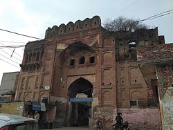 Fort of Prithviraj Chauhan in Taraori | |
 Location in Haryana | |
| Coordinates(Karnal): | |
| Country | India |
| State | Haryana |
| Division | Karnal |
| Headquarters | Karnal |
| Tehsils | 1. Gharaunda, 2. Nilokheri, 3. Indri, 4. Karnal, 5. Assandh |
| Area | |
• Total | 2,520 km2 (970 sq mi) |
| Population (2011) | |
• Total | 1,505,324 |
| • Density | 597/km2 (1,550/sq mi) |
| • Urban | 26.51% |
| Demographics | |
| • Literacy | 74.73% |
| • Sex ratio | 887 |
| Time zone | UTC+05:30 (IST) |
| Lok Sabha constituencies | Karnal (shared with Panipat district) |
| Vidhan Sabha constituencies | 5 |
| Website | http://www.karnal.gov.in/ |
Karnal district is one of the 22 districts of Haryana, a state in North India which constitutes the National Capital Region (NCR) of the country. The city of Karnal is a part of the National Capital Region (NCR) and is the administrative headquarters of the district.
Contents
- History
- Sub-Divisions
- Revenue tehsils
- Assembly constituencies
- Demographics
- Religion
- Languages
- People from Karnal District
- See also
- Notes
- References
- External links
As it lies on National highway 44 (old NH-1), it has a well connected transport system to the nearby major cities like Delhi and Chandigarh. Karnal District is also well connected via railways. Karnal Junction lies on Delhi-Kalka line and major trains stops at this station. The district headquarter also has a small aerodrome known as karnal airport.