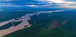
The Essequibo River is the largest river in Guyana, and the largest river between the Orinoco and Amazon. Rising in the Acarai Mountains near the Brazil–Guyana border, the Essequibo flows to the north for 1,014 km (630 mi) through forest and savanna into the Atlantic Ocean. It has a total drainage basin of 156,828 km2 (60,552 sq mi) and an average discharge of 5,650 m3/s (200,000 cu ft/s).
Apoteri is a village in the Upper Takutu-Upper Essequibo Region of Guyana, near the confluence of the Rupununi River with the Essequibo, at an altitude of 53 metres. Apoteri started to develop as the centre of the balatá industry. The population is mainly Amerindian of the Macushi and Wapishana people.
Kumaka is a village in the East Berbice–Corentyne region of Guyana. It stands on the right bank of the upper Essequibo River, about 35 km above Apoteri and the confluence of the Rupununi River with the Essequibo, at an elevation of 105 metres (344 ft).

Kaieteur Airport is an airport serving Kaieteur National Park in the Potaro-Siparuni region of Guyana.

Lethem Airport is an airport serving Lethem, a town in the Upper Takutu-Upper Essequibo region of Guyana. The airport has an 1,825-meter long, asphalt-surface runway.
Linden Airport is an airport serving Linden, the capital of the Upper Demerara-Berbice region of Guyana.
Aishalton Airport is an airport serving the village of Aishalton, in the Upper Takutu-Upper Essequibo Region of Guyana. Its only runway is a 915-meter grass surface.

Annai Airport is an airport serving the village of Annai, in the Upper Takutu-Upper Essequibo Region of Guyana. The 1,000-meter runway has 640 metres (2,100 ft) of asphalt paving, with the remainder grass.
Awaruwaunau Airport is an airport serving the village of Awarewaunau, an Amerindian village in the Upper Takutu-Upper Essequibo Region of Guyana. The grass-surface runway is merely 570 meters long.
Baramita Airport is an airport serving the Amerindian village of Baramita, in the Barima-Waini Region of Guyana. The solitary, 914-meter runway of the airport is a grass surface.
Bartica Airport is an airport serving the town of Bartica, in the Cuyuni-Mazaruni Region of Guyana. The airport's only runway is a 760-meter asphalt strip.
Imbaimadai Airport is an airport serving the village of Imbaimadai, in the Cuyuni-Mazaruni Region of Guyana. The airport's only runway is a grass-surface, 1,219-meter strip.
Karanambo Airport is an airport serving the village of Karanambo, in the Upper Takutu-Upper Essequibo Region of Guyana. The 1,372-meter long runway is a dirt surface.
Lumid Pau Airport is an airport serving the village of Lumid Pau, in the Upper Takutu-Upper Essequibo Region of Guyana. The 1-km long runway has a grass surface.

Mahdia Airport is an airport serving the village of Mahdia, in the Potaro-Siparuni Region of Guyana. The airport's only runway is a 1,067-meter grass strip.
Mountain Point Airport is an airport in the Upper Takutu-Upper Essequibo Region of Guyana. The nearest community is Sand Creek.
Orinduik Airport is an airport serving the mining community of Orinduik in the Potaro-Siparuni Region of Guyana.
Paruima Airport is an airport serving the community of Paruima in the Cuyuni-Mazaruni Region of Guyana.
Ebini Airport is an airport serving the community of Ebini in the Upper Demerara-Berbice Region of Guyana. The 1-kilometer-long runway has a gravel surface.
Karasabai Airport is an airport serving the Macushi community of Karasabai in the Upper Takutu-Upper Essequibo Region of Guyana. A 1,067 meters long gravel strip is the airport's only runway.
