Archer brothers

Last updated

The Archer brothers were among the earliest European settlers in Queensland, Australia. They were explorers and pastoralists. Seven sons of William Archer, a Scottish timber merchant, they spent varying amounts of time in the colony of New South Wales, mainly in parts of what later became Queensland. [1] A substantial number of locations in Queensland were either named by or for them. They were, in order of birth:

Contents

NameBirth – deathIn AustraliaOther details [2]
Charles Archer 1813–18621841 – ??Died in Norway
John Archer1814–18571839 – ??Returned to his occupation as a sailor. Lost at sea.
David Archer1816–19001834 –1852Did not return to Australia
William Archer1818–18961838 – ??Died in Norway
Archibald Archer 1820–19021860 – c.1897Became a member of the Legislative Assembly of Queensland in 1867. Died in Larvik, Norway.
Thomas Archer 1823–19051838 –1849, 1854–1855, 1872–1880Became Agent-General for Queensland in 1881. Appointed C.M.G in 1884
Alexander Archer 1828–18901851 or 1852–1890Bank manager, died with his wife Mary Louisa (daughter of Queensland Premier Robert Mackenzie) on the RMS Quetta in 1890 [3]
Colin Archer 1832–19211853–1861Became a successful shipbuilder in Norway

Brisbane River valley

Sketch of Durundur Station by Charles Archer, 1843 Sketch of Durundur Station by Charles Archer, 31 July 1843.jpg
Sketch of Durundur Station by Charles Archer, 1843

The first of the Archer brothers to settle in Australia was David, who arrived in Sydney in 1834. He was joined by William and Thomas in 1838. Together, they planned to seek pastoral land on the Darling Downs. Delays meant they would be too late to secure good land, so this venture did not proceed. In 1841 David and Thomas, joined by their brother John, travelled to the upper reaches of the Stanley River, an eastern tributary of the Brisbane River. There, near present-day Woodford, they established Durundur Station, [1] a holding of 200 square miles (520 km2), which is equal to 128,000 acres (51,800 ha). [4] Durundur is an aboriginal name for the Moreton Bay Ash (Eucalyptus tessellaris) [5] The Archer name is seen in the main street of Woodford, and in Mount Archer about 12 km (7 mi) to the west.

Charles Archer (1813-1862). ARCHER Charles.jpg
Charles Archer (1813–1862).

Charles Archer arrived in Australia in 1841, and joined his brothers at Durundur in 1843. He was accompanied by the explorer Ludwig Leichhardt, who stayed at Durundur for several months until early 1844. The country at Durundur proved unsuitable for sheep, leading the brothers to take up two runs further west in 1845. [6] One of these was Cooyar, a holding of 71,660 acres (29,000 ha) [4] on Cooyar Creek, a western tributary of the Brisbane River, near present-day Cooyar, 90 kilometres (56 mi) north of Toowoomba, on the New England Highway. The other was Emu Creek, a holding of 32,000 acres (12,950 ha) [4] on Emu Creek, another western tributary of the Brisbane River. [2]

Burnett region

In 1847, Thomas Archer travelled west to the area called Fitzroy Downs by the explorer Thomas Mitchell, near present-day Roma, but did not take up any land. In 1848 he travelled north to the Burnett region, which led to two runs being taken up on the Burnett River in the names of David and Thomas Archer. One of these was named Eidsvold, after Eidsvoll, Norway, where the Archer family had land holdings. The present day town of Eidsvold was named for the nearby property. [6] The other, named Coonambula, was south of Eidsvold on St John Creek, a tributary of the Burnett River.

Near the site of Eidsvold Station is present day Tolderodden Conservation Park. [7] The Archer connection to this name lies in the fact that Colin Archer was born in a house named Tollerodden, in Norway.

Although not on the Burnett River, Maryborough was the main port for the Burnett region, particularly for the export of wool. One of the houses of St Mary's College, Maryborough is named Archer in honour of the contribution of the pioneering family to the Burnett region.

Fitzroy River

In 1853, Charles and William Archer were the first Europeans to explore the Fitzroy River, which they named in honour of Sir Charles FitzRoy, Governor of the Colony of New South Wales. They explored the river valley and marked proposed boundaries for a new run before returning to the Burnett region. [8] In 1855 the brothers took up the run on the Fitzroy River, naming it Gracemere Station in honour of Thomas Archer's bride, Grace, whom he had married in Scotland in 1853. [6] Gracemere homestead was built in 1858, overlooking a shallow lagoon variously known as Padgole, Farris, and Gracemere. The present-day town of Gracemere was named for the station.

In 1860 Archibald Archer joined his brothers at Gracemere. At first both cattle and sheep were raised, but in the early 1870s the station switched entirely to cattle. The city of Rockhampton now stands on part of the original Gracemere run.

Mount Archer National Park is based on Mount Archer, near Rockhampton. The mountain was named in honour of Charles and William Archer, who had named the Berserker Range and Mount Sleipner (both names derived from Norse mythology) in 1853. [9]

Gracemere in Google Maps

Archibald Archer (1820-1902). ARCHER Archibald.jpg
Archibald Archer (1820–1902).

Google Maps shows the central point of Gracemere as near the intersection of Lawrie St (Gavial Gracemere Rd) and Platen St. About 1,000 metres to the north is the intersection of Capricorn Highway and Archer Rd. With satellite imaging enabled, a tree-lined drive can be observed opposite Archer Rd. This extends west for about 2,000 metres to the Gracemere homestead buildings, on the eastern shore of the lagoon.

Other details

John Archer was captain of the schooner "Letitia" in 1844, and then the schooner "Clarence". In 1847 Captain Archer took a position managing Lucknow Station in Gippsland, Victoria and his first wife was buried there the same year. [10] John met his brother Thomas in San Francisco in 1848. John was captain of the "Harriett Nathan" and Thomas had gone to the California goldfields. From 1852 to 1854 John - "Captain Jack" - commanded the barque "Fair Tasmanian" on the Hobart-Twofold Bay route. He then captained the brig "Retriever" until he and his third wife were lost when the "Retriever" is believed to have foundered off the coast of New Zealand after departing Newcastle, Australia. [11]

Archibald Archer was a member of the Queensland Legislative Assembly from 1867 to 1869, and from 1879 to 1895. He served as colonial treasurer and minister for education from 1882 to 1883. [2] He was a supporter of the movement to have Central Queensland declared a separate state. In 1870 he accepted the position of Agent-General for Queensland, but resigned when he realised that his plan to present a petition from the supporters of separation to the Colonial Office was inconsistent with his holding of that position. [2] He was replaced in early 1872 by Richard Daintree.

Thomas Archer was Agent-General for Queensland from 1881 to 1884 and from 1888 to 1890. He was appointed C.M.G. in 1884. [2] While serving as Agent-General he published pamphlets designed to foster interest in Queensland.

Colin Archer was the first to sail a vessel Ellida, a ketch of about twelve tons  up the Fitzroy River to the present site of Rockhampton. He was met by Charles, riding his horse Sleipner, on 1 September 1855. This event is commemorated by a statue of horse and rider on the river bank in Rockhampton. [12] [13] In later life he became a successful shipbuilder in Norway, where he built the Fram , the ship in which Fridtjof Nansen made the successful exploration of the North Polar Sea in 1893 – 1896. [2]

Related Research Articles

<span class="mw-page-title-main">Rockhampton</span> City in Queensland, Australia

Rockhampton is a city in the Rockhampton Region of Central Queensland, Australia. The population of Rockhampton in June 2021 was 79,967, making it the fourth-largest city in the state outside of the cities of South East Queensland, and the 22nd-largest city in Australia. Today, Rockhampton is an industrial and agricultural centre of the north.

<span class="mw-page-title-main">Fitzroy River (Queensland)</span> River in Queensland, Australia

The Fitzroy River is a river located in Central Queensland, Australia. Its catchment covers an area of 142,665 square kilometres (55,083 sq mi), making it the largest river catchment flowing to the eastern coast of Australia. It is also the largest river basin that discharges onto the Great Barrier Reef.

<span class="mw-page-title-main">Gracemere, Queensland</span> Town in Queensland, Australia

Gracemere is a rural town and locality in the Rockhampton Region, Queensland, Australia. In the 2016 census, the locality of Gracemere had a population of 11,315 people.

<span class="mw-page-title-main">Burnett Highway</span> Highway in Queensland, Australia

The Burnett Highway is an inland rural highway located in Queensland, Australia. The highway runs between its junction with the Bruce Highway at Gracemere, just south of Rockhampton, and Nanango. Its length is approximately 542 kilometres. The highway takes its name from the Burnett River, which it crosses in Gayndah. The Burnett Highway provides the most direct link between the northern end of the New England Highway and Rockhampton. It is designated as a State Strategic Road by the Queensland Government.

<span class="mw-page-title-main">Eidsvold, Queensland</span> Town in Queensland, Australia

Eidsvold is a rural town and locality in the North Burnett Region, Queensland, Australia. The town is the self-proclaimed Beef Capital of the Burnett and is a hub for the regional cattle industry. In the 2016 census, the locality of Eidsvold had a population of 574 people.

<span class="mw-page-title-main">Thomas Archer (pastoralist)</span>

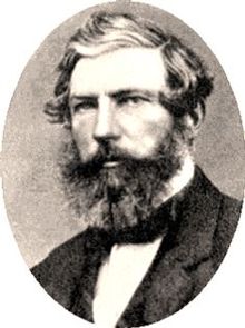
Thomas Archer, CMG was a pioneer pastoralist and Agent General for Queensland (Australia).

<span class="mw-page-title-main">Woodford, Queensland</span> Town in Queensland, Australia

Woodford is a rural town and locality in the Moreton Bay Region, Queensland, Australia. In the 2016 census, the locality of Woodford had a population of 3,458 people.

<span class="mw-page-title-main">Shire of Fitzroy</span> Local government area in Queensland, Australia

The Shire of Fitzroy was a local government area located in the Capricornia region of Central Queensland, Queensland, Australia, to the immediate west and south of the regional city of Rockhampton. The shire, administered from the town of Gracemere, covered an area of 5,898.7 square kilometres (2,277.5 sq mi), and existed as a local government entity from 1899 until 2008, when it amalgamated with several other councils to become the Rockhampton Region. It is named for the Fitzroy River, that passes along the northern boundary of the shire.

<span class="mw-page-title-main">Rockhampton Region</span> Local government area in Queensland, Australia

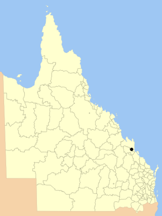
The Rockhampton Region is a local government area (LGA) in Central Queensland, Australia, located on the Tropic of Capricorn about 600 kilometres (370 mi) north of Brisbane. Rockhampton is the region's major city; the region also includes the Fitzroy River, Mount Archer National Park and Berserker Range.
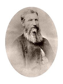
The Berserker Range is a mountainous region located on the eastern and northeastern boundary of the city of Rockhampton in Central Queensland, Australia. Within it lies Mount Archer National Park. It has been designated the Berserker Range Environmental Protection Area by the Rockhampton Regional Council. The southernmost part of the range reaches the Fitzroy River at Broadmount, east of Rockhampton.

<span class="mw-page-title-main">Canoona</span> Suburb of Shire of Livingstone, Queensland, Australia

Canoona is a rural locality in the Livingstone Shire, Queensland, Australia. In the 2016 census, Canoona had a population of 81 people. It was the site of the first North Australian gold rush.

<span class="mw-page-title-main">Gracemere Homestead</span> Historic site in Queensland, Australia

Gracemere Homestead is a heritage-listed homestead at 234 Gracemere Road, Gracemere, Rockhampton Region, Queensland, Australia. It was built from 1858 to 1890s. It was added to the Queensland Heritage Register on 21 October 1992.

<span class="mw-page-title-main">Alexandra Railway Bridge</span> Historic site in Queensland, Australia

Alexandra Railway Bridge is a heritage-listed railway bridge adjacent to North Street, Rockhampton, Rockhampton Region, Queensland, Australia. It was designed by Henry Charles Stanley and built from 1898 to 1899 by George Charles Willcocks. It was added to the Queensland Heritage Register on 21 October 1992.

<span class="mw-page-title-main">Archer Chambers</span> Historic site in Queensland, Australia

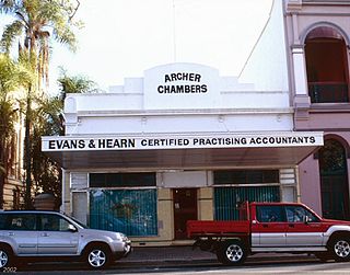
Archer Chambers is a heritage-listed former house and now office building at 206 Quay Street, Rockhampton, Rockhampton Region, Queensland, Australia. It was built in 1870s. It is also known as Evans & Hearn. It was added to the Queensland Heritage Register on 21 October 1992.

<span class="mw-page-title-main">Eidsvold Homestead</span> Heritage-listed homestead

Eidsvold Homestead is a heritage-listed homestead at Eidsvold Road, Eidsvold, North Burnett Region, Queensland, Australia. It was built in 1850. It was added to the Queensland Heritage Register on 21 October 1992.

Rockhampton–Emu Park Road is a continuous 44.1 kilometres (27.4 mi) road route in the Rockhampton and Livingstone local government areas of Queensland, Australia. The route is designated as State Route 4 (Regional) and Tourist Drive 10. It is a state-controlled regional road.

<span class="mw-page-title-main">Tollerodden</span> Peninsula in Norway

Tollerodden, spelt Tolderodden until 1917, is a peninsula located in the bottom of the Larvik fjord and a part of Larvik town located on the southeast coast of Norway.

Eidsvold–Theodore Road is a continuous 143.7 kilometres (89.3 mi) road route in the North Burnett and Banana regions of Queensland, Australia. The entire route is signed as State Route 73. It is a state-controlled district road rated as a local road of regional significance.

Rockhampton–Yeppoon Road is a non-continuous 39.8 kilometres (24.7 mi) road route in the Rockhampton and Livingstone local government areas of Queensland, Australia. Most of the route is designated as State Route 4 (Regional) and Tourist Drive 10. It is a state-controlled regional road.

Kilcoy–Beerwah Road is a continuous 30.4-kilometre (18.9 mi) road route in the Moreton Bay and Sunshine Coast local government areas of Queensland, Australia. It is designated as part of State Route 6. It is a state-controlled regional road. It is part of a route that carries tourist traffic from the New England Highway to the Bruce Highway.

References

  1. 1 2 Archer Family Correspondence 1825–1855, Box: 11261. Heritage Collections State Library of Queensland.
  2. 1 2 3 4 5 6 Mary O'Keeffe (1966). Archer, Charles (1813–1862). Australian Dictionary of Biography. Melbourne University Press. Archived from the original on 13 December 2010. Retrieved 17 December 2009.
  3. "THE LATE MR. ALEXANDER ARCHER". Morning Bulletin . Vol. XLIII, no. 8339. Queensland, Australia. 12 May 1890. p. 5. Archived from the original on 20 August 2022. Retrieved 9 November 2018 via National Library of Australia.
  4. 1 2 3 "The Brisbane Valley". Bellevue Homestead & Vineyard – History. Bellevue Homestead & Vineyard. Archived from the original on 3 October 2009. Retrieved 26 December 2009.
  5. Quenten Walker (1 August 2000). "Early Woodford History". Temple of the Sacred Spiral. fortunecity.com. Archived from the original on 27 February 2010. Retrieved 26 December 2009.
  6. 1 2 3 "Ludwig Leichhardt and the Archers". Archer Family Correspondence 1825–1855, Box: 11261. Heritage Collections State Library of Queensland.
  7. "Tolderodden Conservation Park". National parks, marine parks and forests. Queensland Government. 5 August 2009. Archived from the original on 29 October 2009. Retrieved 17 October 2010.
  8. "Colin Archer's map of the Fitzroy River, 1853". National Library of Australia. University of Queensland Press. 5 February 2019. Archived from the original on 7 February 2019. Retrieved 20 August 2022.
  9. "Mount Archer National Park – Nature, culture and history". Queensland Government. 21 March 2007. Archived from the original on 17 March 2011. Retrieved 17 December 2009.
  10. Gippsland heritage journal, vol. 2, Kapana Press, 1987, p. 47, ISSN   0817-9638
  11. Clarke, Patricia (1986), A colonial woman: the life and times of Mary Braidwood Mowle, 1827-1857, Allen & Unwin, ISBN   978-0-04-909025-5
  12. "Charles Archer and Sleipner". Monument Australia. Archived from the original on 9 March 2011. Retrieved 5 July 2011.
  13. "Bronze statue of Charles Archer on his horse Sleipner, Rockhampton". National Library of Australia. Archived from the original on 20 October 2012. Retrieved 5 July 2011.

Further reading