Mount Archer, Queensland (Rockhampton Region)

Last updated

Mount Archer
Queensland
MtArcher4.jpg
Mount Archer, 2022
Australia Queensland location map.svg
Red pog.svg
Mount Archer
Coordinates 23°19′48″S150°34′49″E / 23.33°S 150.5802°E / -23.33; 150.5802
Population85 (2016 census) [1]
 • Density3.602/km2 (9.33/sq mi)
Postcode(s) 4701
Area23.6 km2 (9.1 sq mi)
Time zone AEST (UTC+10:00)
LGA(s) Rockhampton Region
State electorate(s) Keppel
Federal division(s) Capricornia
Suburbs around Mount Archer:
Limestone Creek Limestone Creek Limestone Creek
Norman Gardens Mount Archer Mount Chalmers
Frenchville Lakes Creek
Nerimbera
Nankin
Mount Archer
Australia Queensland relief location map.jpg
Red triangle with thick white border.svg
Mount Archer
Highest point
Elevation 604 m (1,982 ft)
Coordinates 23°20′00″S150°34′58″E / 23.3333°S 150.5828°E / -23.3333; 150.5828
Geography
Location Queensland, Australia
Parent range Berserker Range
Climbing
Easiest route Road

Mount Archer is a suburb of Rockhampton and a mountain in the Rockhampton Region, Queensland, Australia. [2] [3] [4] In the 2016 census, Mount Archer had a population of 85 people. [1]

Contents

Geography

The mountain is 604 metres (1,982 ft) high, and forms part of the Berserker Range. The Mount Archer National Park surrounds the mountain. Mount Archer is located within the boundaries of the city of Rockhampton. The summit is accessible by a sealed road, Pilbeam Drive, which leads to the upmarket small suburb of Mount Archer, located just below the summit. Lookouts and picnic areas are located on the summit of the mountain, as well as a number of communications towers.

History

The mountain was named in 1859 by surveyor Clarendon Stuart after the Archer brothers who established a pastoral property at Gracemere in 1854. [2]

Frenchville State School opened on 25 January 1981. [5] Located at the base of the mountain, Mount Archer State School is in the present-day suburb of Koongal. [6]

In the 2016 census, Mount Archer had a population of 85 people. [1]

See also

Related Research Articles

<span class="mw-page-title-main">West Rockhampton, Queensland</span> Suburb of Rockhampton, Queensland, Australia

West Rockhampton is a suburb of Rockhampton in the Rockhampton Region, Queensland, Australia. In the 2016 census, West Rockhampton had a population of 1,825 people.

<span class="mw-page-title-main">Berserker, Queensland</span> Suburb of Rockhampton, Queensland, Australia

Berserker is a suburb of Rockhampton in the Rockhampton Region, Queensland, Australia. It is situated about six kilometres north east of the central business district.

The Range is a suburb in the Rockhampton Region, Queensland, Australia. In the 2016 census The Range had a population of 5,400 people.

The Common is a parkland suburb of Rockhampton in the Rockhampton Region, Queensland, Australia. In the 2016 census The Common had a population of 0 people.

The Berserker Range is a mountainous region located on the eastern and northeastern boundary of the city of Rockhampton in Central Queensland, Australia. Within it lies Mount Archer National Park. It has been designated the Berserker Range Environmental Protection Area by the Rockhampton Regional Council. The southernmost part of the range reaches the Fitzroy River at Broadmount, east of Rockhampton.

<span class="mw-page-title-main">Zilzie</span> Suburb of Shire of Livingstone, Queensland, Australia

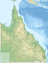
Zilzie is a coastal locality in the Livingstone Shire, Queensland, Australia. In the 2021 census, Zilzie had a population of 2,846 people.

<span class="mw-page-title-main">Raglan, Queensland</span> Town in Queensland, Australia

Raglan is a rural town and locality in the Gladstone Region, Queensland, Australia. In the 2016 census, the locality of Raglan had a population of 146 people.

<span class="mw-page-title-main">Koongal, Queensland</span> Suburb of Rockhampton Region, Queensland, Australia

Koongal is a suburb of Rockhampton in the Rockhampton Region, Queensland, Australia. At the 2016 census, Koongal had a population of 4,286 people.

<span class="mw-page-title-main">Mount Delaney</span> Suburb of City of Moreton Bay, Queensland, Australia

Mount Delaney is a rural locality in the City of Moreton Bay, Queensland, Australia. In the 2016 census Mount Delaney had a population of 85 people.

Kabra is a rural town and locality in the Rockhampton Region, Queensland, Australia. In the 2016 census the locality of Kabra had a population of 421 people.

<span class="mw-page-title-main">Stanwell, Queensland</span> Suburb of Rockhampton Region, Queensland, Australia

Stanwell is a rural town and locality in the Rockhampton Region, Queensland, Australia. In the 2016 census the locality of Stanwell had a population of 337 people.

<span class="mw-page-title-main">Bajool, Queensland</span> Suburb of Rockhampton Region, Queensland, Australia

Bajool is a rural town and locality in the Rockhampton Region, Queensland, Australia. In the 2016 census, the locality of Bajool had a population of 455 people.

<span class="mw-page-title-main">Mount Archer, Queensland (Somerset Region)</span> Suburb of Somerset Region, Queensland, Australia

Mount Archer is a mountain and a rural locality in the Somerset Region, Queensland, Australia. In the 2016 census the locality of Mount Archer had a population of 305 people.

<span class="mw-page-title-main">Nerimbera, Queensland</span> Suburb of Shire of Livingstone, Queensland, Australia

Nerimbera is a rural locality in the Livingstone Shire, Queensland, Australia. In the 2016 census, Nerimbera had a population of 293 people.

<span class="mw-page-title-main">Mount Chalmers, Queensland</span> Town in Queensland, Australia

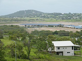
Mount Chalmers is a rural town and locality in the Livingstone Shire, Queensland, Australia. In the 2016 census, the locality of Mount Chalmers had a population of 235 people.

<span class="mw-page-title-main">Mount Sheridan, Queensland</span> Suburb of Cairns, Queensland, Australia

Mount Sheridan is a suburb of Cairns in the Cairns Region, Queensland, Australia. In the 2016 census, Mount Sheridan had a population of 8,271 people.

<span class="mw-page-title-main">Port Curtis, Queensland</span> Suburb of Rockhampton, Queensland, Australia

Port Curtis is a suburb of Rockhampton in the Rockhampton Region, Queensland, Australia. In the 2016 census, Port Curtis had a population of 281 people.

Lakes Creek is a suburb split between Rockhampton Region and Shire of Livingstone, Queensland, Australia. In the 2016 census Lakes Creek had a population of 552 people.

<span class="mw-page-title-main">Boulder Creek, Queensland</span> Suburb of Rockhampton Region, Queensland, Australia

Boulder Creek is a rural locality in the Rockhampton Region, Queensland, Australia. In the 2021 census, Boulder Creek had a population of 13 people.

Eidsvold West is a rural locality in the North Burnett Region, Queensland, Australia. In the 2021 census, Eidsvold West had a population of 85 people.

References

  1. 1 2 3 Australian Bureau of Statistics (27 June 2017). "Mount Archer (SSC)". 2016 Census QuickStats. Retrieved 20 October 2018. OOjs UI icon edit-ltr-progressive.svg
  2. 1 2 "Mount Archer – suburb in Rockhampton Region (entry 48778)". Queensland Place Names. Queensland Government . Retrieved 27 January 2020.
  3. "Mount Archer – mountain in the Rockhampton REgion (entry 767)". Queensland Place Names. Queensland Government . Retrieved 29 January 2020.
  4. "Mount Archer (entry 48778)". Queensland Place Names. Queensland Government . Retrieved 8 August 2015.
  5. "Opening and closing dates of Queensland Schools". Queensland Government . Retrieved 18 April 2019.
  6. "Mount Archer State School". Mount Archer State School. Retrieved 29 January 2020.