The Nearctic realm is one of the eight biogeographic realms constituting the Earth's land surface.

The Arctic National Wildlife Refuge or Arctic Refuge is a national wildlife refuge in northeastern Alaska, United States, on traditional Iñupiaq and Gwich'in lands. The refuge is 19,286,722 acres (78,050.59 km2) of the Alaska North Slope region, with a northern coastline and vast inland forest, taiga, and tundra regions. ANWR is the largest national wildlife refuge in the country, slightly larger than the Yukon Delta National Wildlife Refuge. The refuge is administered from offices in Fairbanks. ANWR is home to a diverse range of endemic mammal species; notably, it is one of the few North American locations with all three endemic American ursids—the polar bear, grizzly bear, and American black bear, each of which resides predominantly in its own ecological niche. Besides the bears, other mammal species include the moose, caribou, wolves, red and Arctic fox, Canada lynx, wolverine, pine marten, American beaver, and North American river otter. Further inland, mountain goats may be seen near the slope. Hundreds of species of migratory birds visit the refuge yearly, and it is a vital, protected breeding location for them. Snow geese, eiders and snowy owl may be observed as well.
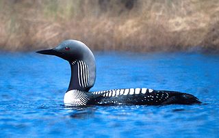
The Pacific loon or Pacific diver, is a medium-sized member of the loon, or diver, family.

The king eider is a large sea duck that breeds along Northern Hemisphere Arctic coasts of northeast Europe, North America and Asia. The birds spend most of the year in coastal marine ecosystems at high latitudes, and migrate to Arctic tundra to breed in June and July. They lay four to seven eggs in a scrape on the ground lined with grass and down.
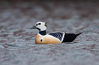
Steller's eider is a migrating Arctic diving duck that breeds along the coastlines of eastern Russia and Alaska. It is the rarest, smallest, and fastest flying of the eider species.

The Alaska North Slope is the region of the U.S. state of Alaska located on the northern slope of the Brooks Range along the coast of two marginal seas of the Arctic Ocean, the Chukchi Sea being on the western side of Point Barrow, and the Beaufort Sea on the eastern. With the exception of the highway connecting Fairbanks to Prudhoe Bay, the region is disconnected from the rest of the Alaskan road system and relies mostly on waterways and small airports for transportation due to the Brooks Range secluding the region from the rest of the state.
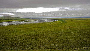
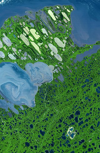
The Colville River is a major river of the Arctic Ocean coast of Alaska in the United States, approximately 350 miles (560 km) long. One of the northernmost major rivers in North America, it drains a remote area of tundra on the north side of the Brooks Range entirely above the Arctic Circle in the southwestern corner of the National Petroleum Reserve-Alaska. The river is frozen for more than half the year and floods each spring.The Colville River and its adjacent hills are home to a variety of Arctic wildlife, including Lake Teshekpuk and Central Arctic caribou herds, and hawks.

Cape Krusenstern National Monument and the colocated Cape Krusenstern Archeological District is a U.S. National Monument and a National Historic Landmark centered on Cape Krusenstern in northwestern Alaska. The national monument was one of fifteen new National Park Service units designated by the Alaska National Interest Lands Conservation Act (ANILCA) of 1980. It was initially declared a national monument under the authority of the Antiquities Act by President Jimmy Carter on December 1, 1978.
Teshekpuk Lake is the largest lake in Arctic Alaska, at 22 miles (35 km) width on the Alaska North Slope within the National Petroleum Reserve-Alaska, South of Pitt Point, 12 miles (19 km) east of Harrison Bay, 80 miles (130 km) east of Point Barrow. The Teshekpuk Lake region is considered one of the most productive, diverse, and sensitive wetland ecosystems in the entire Arctic, habitat to a variety of arctic wildlife, including the resident Teshekpuk Lake caribou herd of 64,000 animals, large numbers of shorebirds and migratory waterfowl, for whom it is an essential part of the East Asian–Australasian Flyway site network.

The Yukon Delta National Wildlife Refuge is a United States National Wildlife Refuge covering about 19.16 million acres (77,500 km2) in southwestern Alaska. It is the second-largest National Wildlife Refuge in the country, only slightly smaller than the Arctic National Wildlife Refuge. It is a coastal plain extending to the Bering Sea, covering the delta created by the Yukon and Kuskokwim rivers. The delta includes extensive wetlands near sea level that are often inundated by Bering Sea tides. It is bordered on the east by Wood-Tikchik State Park, the largest state park in the United States. The refuge is administered from offices in Bethel.

Arctic Alaska or Far North Alaska is a region of the U.S. state of Alaska generally referring to the northern areas on or close to the Arctic Ocean.

The Chukchi Shelf or Chukchi Sea Shelf is the westernmost part of the continental shelf of the United States and the easternmost part of the continental shelf of Russia. In the west it merges with the Russian Siberian Shelf. Within this shelf, the 50-mile Chukchi Corridor acts as a passageway for one of the largest marine mammal migrations in the world.

The Arctic foothills tundra is an ecoregion of the far north of North America, lying inland from the north coast of Alaska. This is permafrost tundra with an average annual temperature below freezing.

The Hudson Plains Ecoregion is a vast, flat, and waterlogged landscape. This ecoregion covers a 369,000 square kilometer area along the south shoreline of the Hudson Bay, which includes the Canadian provinces of Eastern Quebec, Northern Ontario and Western Manitoba. Because of the location of the ecoregion, winter prevails for many months of the year and rising temperatures, along with melting ice, makes fog common. The short summers provide a home for thousands of migrating birds. The region is used by humans for its mineral resources and hydroelectric power as a result of the abundance of water and emergent societal needs. Though relatively uninhabited and undisturbed, the natural resources of the Hudson Plains are still subject to anthropogenic activities. Its climatic, geographic, and evolutionary patterns categorize it as one of many ecoregions in North America.
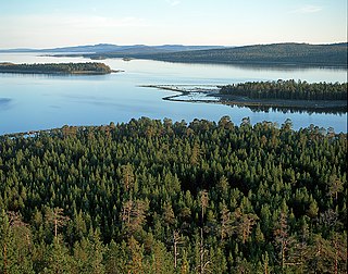
Kandalaksha Nature Reserve is a Russian 'zapovednik' on the south shore of Kandalaksha Bay in the Murmansk and Karelia regions on the opening to the White Sea. The reserve also includes two small sectors on the northern coast of the Kola peninsula on the Barents Sea; notably, the warm Atlantic current causes the northern sectors on the Barents Sea to be warmer than the more southerly White Sea sectors. Over 550 islands are covered in the boundaries of the reserve. It is one of the oldest nature reserves in Russia, created in 1932 to protect the marine habitats and waterfowl of the region, particularly the eider. The reserve is situated in the Kandalakshsky District, Kolsky District, and Lovozersky District of Murmansk Oblast. The nearest city, Kandalaksha, is at the northwest entrance to the Kandalaksha Gulf, about 5 km from the nearest point in the reserve. Since 1976, the reserve has been part of the Ramsar wetland site of international importance "Kandalaksha Bay". It covers an area of 70,530 ha (272.3 sq mi).
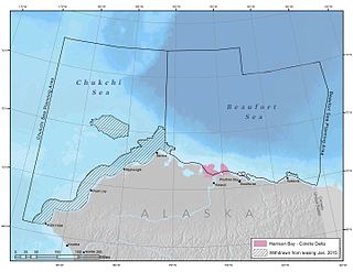
Harrison Bay is an estuary located north of Alaska that opens into the Beaufort Sea. It is adjacent to the Colville Delta. The powerful outflow of the Colville River creates a shallow region that is rich with nutrients, making it ecologically significant for wildlife.
Colville Delta is a river delta in northern Alaska that flows into Harrison Bay. The delta is so flat that it has been said that it is indiscernible where the river ends and the ocean begins. The powerful outflow of the Colville River creates a shallow region that is rich with nutrients, making it ecologically significant for wildlife.

Barrow Canyon is a submarine canyon that straddles the boundary between the Beaufort and Chukchi seas. Compared to other nearby areas and the Canada Basin, the highly productive Barrow Canyon supports a diversity of marine animals and invertebrates.

The Southern Hudson Bay taiga is a terrestrial ecoregion, as classified by the World Wildlife Fund, which extends along the southern coast of Hudson Bay and resides within the larger taiga biome. The region is nearly coterminous with the Hudson Plain, a Level I ecoregion of North America as designated by the Commission for Environmental Cooperation (CEC) in its North American Environmental Atlas.

The Tundra of North America is a Level I ecoregion of North America designated by the Commission for Environmental Cooperation (CEC) in its North American Environmental Atlas.