Kenai Peninsula Borough, Alaska

Last updated

Kenai Peninsula Borough
Overhead view of Homer and Kachemak Bay.jpg
Sunrise on Kachemak Bay.jpg
Kenai River Alaska.jpg
Coral Seymour Ballpark.jpg
Mount Alice seen from Mount Marathon.jpg
Turnagain Arm and Kenai Mountains (1).jpg
Left to right, from top: Overhead view of Homer and Kachemak Bay, sunrise on Kachemak Bay, view of Kenai Lake, the Coral Seymour Memorial Ballpark, view of Mount Alice at Seward, view of the Kenai Mountains
Kenai Peninsula Borough, Alaska seal.png
Map of Alaska highlighting Kenai Peninsula Borough.svg
Location within the U.S. state of Alaska
Alaska in United States (US50).svg
Alaska's location within the U.S.
Coordinates: 60°25′00″N151°15′00″W / 60.416666666667°N 151.25°W / 60.416666666667; -151.25
CountryFlag of the United States.svg United States
StateFlag of Alaska.svg  Alaska
Incorporated January 1, 1964 [1] [2]
Named for Kenai Peninsula
Seat Soldotna
Largest city Kalifornsky
Area
  Total24,752 sq mi (64,110 km2)
  Land16,075 sq mi (41,630 km2)
  Water8,677 sq mi (22,470 km2)  35.1%
Population
 (2020)
  Total58,799
  Estimate 
(2022)
60,690 Increase2.svg
  Density2.4/sq mi (0.92/km2)
Time zone UTC−9 (Alaska)
  Summer (DST) UTC−8 (ADT)
Congressional district At-large
Website www.borough.kenai.ak.us

Kenai Peninsula Borough is a borough of the U.S. state of Alaska. As of the 2020 census, the population was 58,799, up from 55,400 in 2010. [3] The borough seat is Soldotna, [4] the largest city is Kenai, and the most populated community is the census-designated place of Kalifornsky.

Contents

The borough includes most of the Kenai Peninsula and a large area of the mainland of Alaska on the opposite side of Cook Inlet.

Geography

View of Seldovia, located along Kachemak Bay Seldovia.jpg
View of Seldovia, located along Kachemak Bay

The borough has a total area of 24,752 square miles (64,110 km2), of which 16,075 square miles (41,630 km2) is land and 8,677 square miles (22,470 km2) (3.4%) is water. [5]

Adjacent boroughs and census areas

National protected areas

Ecology

Bear Lake, Tutka Bay, and the Trail Lakes, have been the site of salmon enhancement activities. All three sites are managed by the Cook Inlet Aquaculture Association [6] Some of the fish hatched at these facilities are released into the famous Homer fishing hole. Cook Inlet Keeper and the Cook Inlet Regional Citizen's Advisory Council are groups that attempt to influence public policy on the use of the area's resources.

Demographics

Historical population
CensusPop.Note
1960 6,097
1970 14,250133.7%
1980 25,28277.4%
1990 40,80261.4%
2000 49,69121.8%
2010 55,40011.5%
2020 58,7996.1%
2023 (est.)61,223 [7] 4.1%
U.S. Decennial Census [8]
1790-1960 [9] 1900-1990 [10]
1990-2000 [11] 2010-2020 [3]

2020 census

As of the census of 2020, there were 58,799 people.

2000 census

As of the census of 2000, there were 49,700 people, 18,400 households, and 12,700 families residing in the borough. The population density was 1/km2 (3/sq mi). There were 24,900 housing units at an average density of 2 per square mile (0.77/km2). The racial makeup of the borough was 86% white, 7% Native American, 2% Hispanic or Latino (any race), and 4% from two or more races. Black or African Americans, Asians, and Pacific Islanders each were less than 1%. [12] Just under 1% were from other races combined. 1.92% reported speaking Russian at home, while 1.74% spoke Spanish. [13]

Of the 18,400 households, 38% had children under the age of 18 living with them, 55% were married couples living together, 9% had a female householder with no husband present, and 31% were non-families. 25% of households were one person, and 5% were one person aged 65 or older. The average household size was 2.6 and the average family size was 3.2.

In the borough the population was spread out, with 30% under the age of 18, 7% from 18 to 24, 30% from 25 to 44, 26% from 45 to 64, and 7% 65 or older. The median age was 36 years. For every 100 females, there were 109 males; for every 100 females age 18 and over there were 110 males.

Government and infrastructure

There is a borough-wide government based in Soldotna, consisting of a strong mayor and an assembly of representatives from all areas of the borough. They collect sales and property taxes and provide services such as road maintenance, waste collection facilities, emergency services and major funding for public schools, along with mitigation of damage from spruce bark beetles that infested the borough in the late 1990s and early 2000s. [14] Incorporated towns also have their own local governments and city councils. The Alaska Department of Corrections operates the Spring Creek Correctional Center near Seward [15] [16] and the Wildwood Correctional Complex near Kenai.

United States presidential election results for Kenai Peninsula Borough, Alaska [17]
Year Republican Democratic Third party
No.%No.%No.%
2020 21,76164.10%10,96532.30%1,2223.60%
2016 18,40867.02%7,57827.59%1,4815.39%
2012 17,15767.35%7,72130.31%5982.35%
2008 18,94967.30%8,36229.70%8453.00%
2004 10,47867.93%4,64830.13%2991.94%
2000 15,05366.81%4,63320.56%2,84612.63%
1996 10,60658.13%5,17728.37%2,46213.49%
1992 6,90237.50%4,82826.23%6,67636.27%
1988 8,63361.05%4,71833.37%7895.58%
1984 10,29770.38%3,68725.20%6464.42%
1980 7,02060.78%2,17818.86%2,35220.36%
1976 4,69761.56%2,52833.13%4055.31%
1972 3,21457.45%1,52027.17%86015.37%
1968 2,04439.35%2,16941.76%98118.89%
1964 1,26535.49%2,29964.51%00.00%
1960 1,57347.29%1,75352.71%00.00%

Communities

The George A. Navarre Building on Binkley Street in downtown Soldotna serves as the administrative headquarters for the borough and its school district. Navarre moved to Kenai in 1957, owned and operated a variety of Kenai-based businesses, and was the borough's mayor from 1966 to 1972. His son, Mike Navarre, was mayor from 1996 to 1999 and 2011 to 2017. Kenai Peninsula Borough Building.jpg
The George A. Navarre Building on Binkley Street in downtown Soldotna serves as the administrative headquarters for the borough and its school district. Navarre moved to Kenai in 1957, owned and operated a variety of Kenai-based businesses, and was the borough's mayor from 1966 to 1972. His son, Mike Navarre, was mayor from 1996 to 1999 and 2011 to 2017.

Cities

Census-designated places

Unincorporated communities

Ghost town

Education

The school district for the whole borough is Kenai Peninsula Borough School District. [18]

See also

Related Research Articles

<span class="mw-page-title-main">Southcentral Alaska</span> Region of the U.S. state of Alaska

Southcentral Alaska, also known as the Gulf Coast Region, is the portion of the U.S. state of Alaska consisting of the shorelines and uplands of the central Gulf of Alaska. More than half of the state's entire population lives in this region, concentrated in and around the city of Anchorage. The region is Alaska’s best-connected region, with the Port of Anchorage, Ted Stevens, Anchorage International Airport, and the Alaska Railroad servicing the area.

<span class="mw-page-title-main">Kodiak Island Borough, Alaska</span> Borough in Alaska, United States

Kodiak Island Borough is a borough in the U.S. state of Alaska. At the 2020 census, the population was 13,101, down from 13,592 in 2010. The borough seat is Kodiak.

<span class="mw-page-title-main">Lake and Peninsula Borough, Alaska</span> Borough in Alaska, United States

Lake and Peninsula Borough is a borough in the state of Alaska. As of the 2020 census, the population was 1,476, down from 1,631 in 2010. The borough seat of King Salmon is located in neighboring Bristol Bay Borough, although is not the seat of that borough. The most populous community in the borough is the census-designated place of Port Alsworth. With an average of 0.017 inhabitants per square kilometre, the Lake and Peninsula Borough is the second least densely populated organized county-equivalent in the United States; only the unorganized Yukon-Koyukuk Census Area has a lower density.

<span class="mw-page-title-main">Matanuska-Susitna Borough, Alaska</span> Borough in Alaska, United States

Matanuska-Susitna Borough is a borough located in the U.S. state of Alaska. Its borough seat is Palmer, and the largest community is the census-designated place of Knik-Fairview. As of the 2020 census, the borough's population was 107,801.

<span class="mw-page-title-main">Bear Creek, Alaska</span> Census-designated place in Alaska, United States

Bear Creek is a census-designated place (CDP) in Kenai Peninsula Borough, Alaska, United States. At the 2020 census the population was 2,129 up from 1,956 in 2010. Bear Creek is a few miles north of Seward near the stream of the same name and its source, Bear Lake.

<span class="mw-page-title-main">Cohoe, Alaska</span> Census-designated place in Alaska, United States

Cohoe (Dena'ina: Qughuhnaz’ut) is a census-designated place (CDP) in Kenai Peninsula Borough, Alaska, United States. At the 2010 census the population was 1,364, up from 1,168 in 2000.

<span class="mw-page-title-main">Cooper Landing, Alaska</span> Census-designated place in Alaska, United States

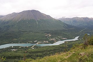
Cooper Landing is a census-designated place (CDP) in Kenai Peninsula Borough, Alaska, United States, about 100 miles (160 km) south of Anchorage, at the outlet of Kenai Lake into the Kenai River. The town was first settled in the 19th century by gold and mineral prospectors, and has become a popular summer tourist destination thanks to its scenic location and proximity to the salmon fishery of the Kenai River and Russian River. As of the 2010 census, the population in Cooper Landing was 289, down from 369 in 2000.

<span class="mw-page-title-main">Hope, Alaska</span> Census-designated place in Alaska, United States

Hope is a census-designated place (CDP) in Kenai Peninsula Borough in the U.S. state of Alaska. It is eighty-seven miles south from Anchorage. As of the 2010 census the population was 192, up from 137 in 2000.

<span class="mw-page-title-main">Kalifornsky, Alaska</span> Census-designated place in Alaska, United States

Kalifornsky is a census-designated place (CDP) in Kenai Peninsula Borough, Alaska, United States. The population was 8,487 at the 2020 census, up from 7,850 in 2010. It is the most populated locality in the borough.

<span class="mw-page-title-main">Kenai, Alaska</span> City in Alaska, United States

Kenai is a city in the Kenai Peninsula Borough in the U.S. state of Alaska. By road, it is 158 miles southwest of Anchorage. The population was 7,424 as of the 2020 census, up from 7,100 in 2010, the fifteenth-most populated city in the state.

<span class="mw-page-title-main">Moose Pass, Alaska</span> Census-designated place in Alaska, United States

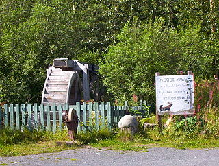
Moose Pass is a census-designated place (CDP) in Kenai Peninsula Borough, Alaska, United States. The population was 219 at the 2010 census, up from 206 in 2000.

Ridgeway is a census-designated place (CDP) in Kenai Peninsula Borough, Alaska, United States. At the 2020 census the population was 2,136, up from 2,022 in 2010.

<span class="mw-page-title-main">Seldovia, Alaska</span> City in Alaska, United States

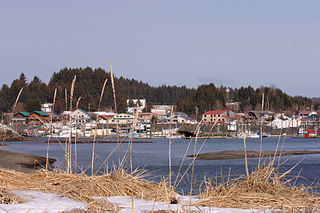
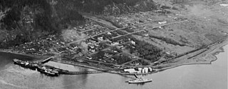
Seldovia is a city in Kenai Peninsula Borough, Alaska, United States. Its population was 255 at the 2010 census, down from 286 in 2000. It is located along Kachemak Bay southwest of Homer. There is no road system connecting the town to other communities, so all travel to Seldovia is by airplane or boat.

<span class="mw-page-title-main">Seward, Alaska</span> City in Alaska, United States

Seward is an incorporated home rule city in Alaska, United States. Located on Resurrection Bay, a fjord of the Gulf of Alaska on the Kenai Peninsula, Seward is situated on Alaska's southern coast, approximately 120 miles (190 km) by road from Alaska's largest city, Anchorage.

<span class="mw-page-title-main">Soldotna, Alaska</span> City in Alaska, United States

Soldotna is a city in the Kenai Peninsula Borough in the U.S. state of Alaska. At the 2020 census, the population was 4,342, up from 4,163 in 2010. It is the seat of the Kenai Peninsula Borough.

<span class="mw-page-title-main">Kenai Peninsula</span> Large peninsula in south central Alaska, United States

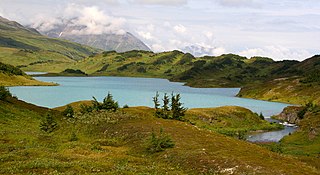
The Kenai Peninsula is a large peninsula jutting from the coast of Southcentral Alaska. The name Kenai is derived from the word "Kenaitze" or "Kenaitze Indian Tribe", the name of the Native Athabascan Alaskan tribe, the Kahtnuht’ana Dena’ina, who historically inhabited the area. They called the Kenai Peninsula Yaghanen.

<span class="mw-page-title-main">Sterling Highway</span> Highway in Alaska

The Sterling Highway is a 138-mile-long (222 km) state highway in the south-central region of the U.S. state of Alaska, leading from the Seward Highway at Tern Lake Junction, 90 miles (140 km) south of Anchorage, to Homer.

<span class="mw-page-title-main">Chugach National Forest</span> National Forest in Alaska, United States

The Chugach National Forest is a 6,908,540-acre (27,958 km2) United States National Forest in south central Alaska. Covering portions of Prince William Sound, the Kenai Peninsula and the Copper River Delta, it was formed in 1907 from part of a larger forest reserve. The Chugach includes extensive shorelines, glaciers, forests and rivers, much of which is untouched by roads or trails. It hosts numerous bird, mammal and marine species, including extensive shorebird habitat and a bald eagle population larger than the contiguous 48 states combined. Human industry in the forest includes extensive tourism and some mining and oil and gas operations.

<span class="mw-page-title-main">Denaʼina</span>

The Denaʼina, or formerly Tanaina, are an Alaska Native Athabaskan people. They are the original inhabitants of the south central Alaska region ranging from Seldovia in the south to Chickaloon in the northeast, Talkeetna in the north, Lime Village in the northwest and Pedro Bay in the southwest. The Denaʼina homeland is more than 41,000 sq mi (110,000 km2) in area. They arrived in the south-central Alaska sometime between 1,000 and 1,500 years ago. They were the only Alaskan Athabaskan group to live on the coast. The Denaʼina have a hunter-gatherer culture and a matrilineal system. The Iditarod Trail's antecedents were the native trails of the Denaʼina and Deg Hitʼan Athabaskan Native Alaskans and the Inupiaq Inuit.

Alan S. Boraas is a professor of anthropology at Kenai Peninsula College in Alaska. He is known for his research into the culture, history, and archaeology of the peoples of the Cook Inlet area of Alaska, and in particular has worked closely with the Dena'ina people of the Kenai Peninsula. He is an adopted honorary member of the Kenaitze Indian Tribe, and is helping the tribe develop a program to teach the Dena'ina language.

References

  1. "Kenai Peninsula Borough, Resolution No. 1: Legal Status - Borough and Borough School District" (PDF). Kenai Peninsula Borough. January 4, 1964. Archived (PDF) from the original on October 9, 2022. Retrieved May 3, 2012.
  2. 1996 Alaska Municipal Officials Directory. Juneau: Alaska Municipal League/Alaska Department of Community and Regional Affairs. January 1996. p. 8.
  3. 1 2 "State & County QuickFacts". United States Census Bureau. Retrieved April 15, 2023.
  4. "Kenai Peninsula Borough Profile". National Association of Counties. Retrieved November 3, 2021.
  5. "US Gazetteer files: 2010, 2000, and 1990". United States Census Bureau. February 12, 2011. Retrieved April 23, 2011.
  6. "Project Bear Lake". Archived from the original on September 7, 2007. Retrieved February 3, 2007.
  7. "Annual Estimates of the Resident Population for Counties: April 1, 2020 to July 1, 2023". United States Census Bureau. Retrieved March 28, 2024.
  8. "U.S. Decennial Census". United States Census Bureau. Retrieved May 18, 2014.
  9. "Historical Census Browser". University of Virginia Library. Retrieved May 18, 2014.
  10. "Population of Counties by Decennial Census: 1900 to 1990". United States Census Bureau. Retrieved May 18, 2014.
  11. "Census 2000 PHC-T-4. Ranking Tables for Counties: 1990 and 2000" (PDF). United States Census Bureau. Archived (PDF) from the original on October 9, 2022. Retrieved May 18, 2014.
  12. "U.S. Census website". United States Census Bureau . Retrieved May 14, 2011.
  13. "Language Map Data Center". Mla.org. July 17, 2007. Retrieved December 20, 2012.
  14. "Kenai Peninsula Borough Government official site". Borough.kenai.ak.us. Retrieved December 20, 2012.
  15. "City of Seward 2020 Comprehensive Plan Volume II Archived June 8, 2011, at the Wayback Machine ." City of Seward. 94/97. Retrieved on August 15, 2010.
  16. "Spring Creek Correctional Center Archived August 26, 2010, at the Wayback Machine ." Alaska Department of Corrections. Retrieved on August 15, 2010.
  17. Elections, RRH. "RRH Elections". rrhelections.com. Retrieved January 12, 2020.
  18. "2020 CENSUS - SCHOOL DISTRICT REFERENCE MAP: Kenai Peninsula Borough, AK" (PDF). United States Census Bureau. Archived (PDF) from the original on October 9, 2022. Retrieved July 27, 2022. - Text list

60°25′N151°15′W / 60.417°N 151.250°W / 60.417; -151.250