Halibut Cove, Alaska

Last updated

Halibut Cove, Alaska
Halibut Cove Alaska.jpg
The harbor at Halibut Cove
AKMap-doton-HalibutCove.PNG
Location of Halibut Cove, Alaska
Coordinates: 59°35′51″N151°14′5″W / 59.59750°N 151.23472°W / 59.59750; -151.23472
Country United States
State Alaska
Borough Kenai Peninsula
Government
  Borough mayor Peter Micciche
   State senator Gary Stevens (R)
   State rep. Sarah Vance (R)
Area
[1]
  Total11.49 sq mi (29.76 km2)
  Land8.32 sq mi (21.55 km2)
  Water3.17 sq mi (8.21 km2)
Elevation
20 ft (6 m)
Population
 (2020)
  Total60
  Density7.21/sq mi (2.78/km2)
Time zone UTC-9 (Alaska (AKST))
  Summer (DST) UTC-8 (AKDT)
ZIP code
99603
Area code 907
FIPS code 02-31270

Halibut Cove is a census-designated place (CDP) in Kenai Peninsula Borough, Alaska, United States. The population was 76 at the 2010 census, [2] up from 35 in 2000.

Contents

Originally a fishing village, Halibut Cove is now home to several artists and businesses. One of the only floating U.S. post offices is there. A popular tourist destination, the cove offers several lodges and cabins and the only way to get around the cove is by boat.

Geography

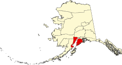
Halibut Cove is located in the southern part of the Kenai Peninsula at 59°35′51″N151°14′5″W / 59.59750°N 151.23472°W / 59.59750; -151.23472 (59.597549, -151.234607). [3] It lies on the south side of Kachemak Bay, 10 miles (16 km) southeast of Homer. The CDP is bordered to the east by Halibut Cove and to the west by China Poot Bay, both of which are arms of Kachemak Bay. The town center is on Ismailof Island, lying 500 feet (150 m) off the main peninsula across a small narrows. Peterson Bay is an inlet west of Ismailof Island.

According to the United States Census Bureau, the CDP has a total area of 11.5 square miles (29.8 km2), of which 8.3 square miles (21.5 km2) are land and 3.2 square miles (8.2 km2), or 27.60%, are water. [2]

Visitors reach Halibut Cove by private boat from Homer; by the locally operated ferry, the Danny J.', 'Stormbird; or by float plane. There is no road access; the primary modes of transportation within the cove are by foot, skiff, or ATV. Areas open to the public around the lagoon are connected by boardwalks, and many homes and businesses are fully or partially constructed on pilings over the water.

Climate

Nabesna has a continental subarctic climate (Köppen Dsc).

Climate data for Halibut Cove, Alaska (1975-1998 normals and extremes)
MonthJanFebMarAprMayJunJulAugSepOctNovDecYear
Record high °F (°C)50
(10)
52
(11)
51
(11)
58
(14)
73
(23)
74
(23)
78
(26)
74
(23)
69
(21)
61
(16)
52
(11)
46
(8)
78
(26)
Mean daily maximum °F (°C)30.6
(−0.8)
31.5
(−0.3)
36.2
(2.3)
44.7
(7.1)
52.6
(11.4)
59.8
(15.4)
63.0
(17.2)
62.2
(16.8)
54.3
(12.4)
43.9
(6.6)
34.2
(1.2)
31.1
(−0.5)
45.4
(7.4)
Mean daily minimum °F (°C)21.0
(−6.1)
20.1
(−6.6)
23.0
(−5.0)
30.7
(−0.7)
37.0
(2.8)
42.9
(6.1)
47.1
(8.4)
46.9
(8.3)
40.4
(4.7)
31.3
(−0.4)
24.4
(−4.2)
21.2
(−6.0)
32.2
(0.1)
Record low °F (°C)−20
(−29)
−4
(−20)
−1
(−18)
14
(−10)
22
(−6)
27
(−3)
35
(2)
37
(3)
25
(−4)
4
(−16)
−1
(−18)
−10
(−23)
−20
(−29)
Average precipitation inches (mm)4.22
(107)
3.29
(84)
3.46
(88)
3.08
(78)
1.98
(50)
1.15
(29)
1.24
(31)
2.55
(65)
5.02
(128)
4.12
(105)
4.15
(105)
5.90
(150)
40.17
(1,020)
Average snowfall inches (cm)16.8
(43)
14.4
(37)
14.7
(37)
3.8
(9.7)
0.0
(0.0)
0.0
(0.0)
0.0
(0.0)
0.0
(0.0)
0.0
(0.0)
3.3
(8.4)
12.7
(32)
22.6
(57)
88.3
(224)
Source: WRCC [4]

Demographics

Historical population
CensusPop.Note
1940 23
1960 25
1970 4476.0%
1980 476.8%
1990 7866.0%
2000 35−55.1%
2010 76117.1%
2020 60−21.1%
U.S. Decennial Census [5]

Halibut Cove first appeared on the 1940 U.S. Census as an unincorporated village. It did not appear on the 1950 census, but returned again in 1960, and in every successive census to date. It was made a census-designated place (CDP) in 1980.

The cove seen from atop the Arch Trail Covefromarch.jpg
The cove seen from atop the Arch Trail

As of the census of 2010, there were 76 people, 34 households, and 21 families residing in the CDP. There were 161 housing units, of which 127, or 78.9%, were vacant. 99 of the vacant housing units were for seasonal or vacation use. The racial makeup of the CDP was 86.8% white, 6.6% Alaska Native American, and 6.6% from two or more races. [6]

Of the 34 households, 17.6% had children under the age of 18 living with them, 55.9% were headed by married couples living together, and 38.2% were non-families. 32.4% of all households were individuals, and 14.7% were someone living alone age 65 years or older. The average household size was 2.24, and the average family size was 2.57. [6]

In the CDP, 10.5% of the population were under the age of 18, 13.1% were from 18 to 24, 23.6% were from 25 to 44, 38.1% were from 45 to 64, and 14.5% were 65 years of age or older. The median age was 47.5 years. For every 100 females, there were 117.1 males. For every 100 females age 18 and over, there were 119.4 males. [6]

Typical example of the type of construction used in Halibut Cove lagoon Halibut Cove house on pilings.jpg
Typical example of the type of construction used in Halibut Cove lagoon

Related Research Articles

<span class="mw-page-title-main">Kenai Peninsula Borough, Alaska</span> Borough in Alaska, United States

Kenai Peninsula Borough is a borough of the U.S. state of Alaska. As of the 2020 census, the population was 58,799, up from 55,400 in 2010. The borough seat is Soldotna, the largest city is Kenai, and the most populated community is the census-designated place of Kalifornsky.

<span class="mw-page-title-main">Anchor Point, Alaska</span> Census-designated place in Alaska, United States

Anchor Point is an unincorporated community and census-designated place (CDP) in Kenai Peninsula Borough, in the U.S. state of Alaska. As of the 2010 census the population was 1,930, up from 1,845 in 2000. The community is located along the Sterling Highway, part of Alaska State Route 1. Anchor Point is the westernmost point in the North American highway system.

<span class="mw-page-title-main">Bear Creek, Alaska</span> Census-designated place in Alaska, United States

Bear Creek is a census-designated place (CDP) in Kenai Peninsula Borough, Alaska, United States. At the 2020 census the population was 2,129 up from 1,956 in 2010. Bear Creek is a few miles north of Seward near the stream of the same name and its source, Bear Lake.

<span class="mw-page-title-main">Beluga, Alaska</span> Census-designated place in Alaska, United States

Beluga is a census-designated place (CDP) in Kenai Peninsula Borough, Alaska, United States. The population was 20 at the 2010 census, down from 32 in 2000.

<span class="mw-page-title-main">Clam Gulch, Alaska</span> Census-designated place in Alaska, United States

Clam Gulch is a census-designated place (CDP) in Kenai Peninsula Borough, Alaska, United States. At the 2020 census, the population was 207.

<span class="mw-page-title-main">Cohoe, Alaska</span> Census-designated place in Alaska, United States

Cohoe (Dena'ina: Qughuhnaz’ut) is a census-designated place (CDP) in Kenai Peninsula Borough, Alaska, United States. At the 2010 census the population was 1,364, up from 1,168 in 2000.

<span class="mw-page-title-main">Diamond Ridge, Alaska</span> Census-designated place in Alaska, United States

Diamond Ridge is a census-designated place (CDP) just outside Homer in Kenai Peninsula Borough, Alaska, United States. At the 2010 census the population was 1,156, down from 1,802 in 2000.

<span class="mw-page-title-main">Fox River, Alaska</span> Census-designated place in Alaska, United States

Fox River is a census-designated place (CDP) in Kenai Peninsula Borough, Alaska, United States. At the 2010 census the population was 685, up from 616 in 2000. It was first reported by the U.S. Geological Survey in 1895. The Fox River, which flows by the CDP, might have been named for Theodore Fox, a local mining magnate.

<span class="mw-page-title-main">Fritz Creek, Alaska</span> Census-designated place in Alaska, United States

Fritz Creek is a census-designated place (CDP) in the Kenai Peninsula Borough, Alaska, United States, northeast of Homer. At the 2020 census the population was 2,248, up from 1,932 in 2010.

Happy Valley is a census-designated place (CDP) in Kenai Peninsula Borough, Alaska, United States. At the 2010 census the population was 593, up from 489 in 2000.

<span class="mw-page-title-main">Homer, Alaska</span> City in south-central Alaska, United States

Homer is a city in Kenai Peninsula Borough in the U.S. state of Alaska. It is 218 mi (351 km) southwest of Anchorage. According to the 2020 Census, the population is 5,522, up from 5,003 in 2010. Long known as the "Halibut Fishing Capital of the World", Homer is also nicknamed "the end of the road", and more recently, "the cosmic hamlet by the sea".

<span class="mw-page-title-main">Kachemak, Alaska</span> City in Alaska, United States

Kachemak, locally known as Kachemak City, is a small second-class city in the southern portion of the Kenai Peninsula Borough, Alaska, United States. The city consists of several subdivisions and other miscellaneous properties along an approximately 2-mile (3.2 km) stretch of East End Road, adjoining the northeast corner of the much larger city of Homer. The population grew from 431 as of the 2010 census to 576 at the 2020 census.

<span class="mw-page-title-main">Kasilof, Alaska</span> Census-designated place in Alaska, United States

Kasilof is a census-designated place (CDP) in Kenai Peninsula Borough, Alaska, United States. At the 2020 census the population was 525, down from 549 in 2010.

<span class="mw-page-title-main">Nanwalek, Alaska</span> Census-designated place in Alaska, United States

Nanwalek, formerly Alexandrovsk and later English Bay, is a census-designated place (CDP) in the Kenai Peninsula Borough, Alaska, United States, that contains a traditional Alutiiq village. The population was 254 at the 2010 census, up from 177 in 2000. There is one school located in the community, attended by 76 students.

<span class="mw-page-title-main">Nikiski, Alaska</span> Census-designated place in Alaska, United States

Nikiski is a census-designated place (CDP) in Kenai Peninsula Borough, Alaska, United States. The population was 4,456 at the 2020 census, down from 4,493 in 2010.

<span class="mw-page-title-main">Port Graham, Alaska</span> Census-designated place in Alaska, United States

Port Graham, also known as Paluwik (pah-LU-wig) in the Alutiiq language, is a census-designated place (CDP) in Kenai Peninsula Borough, Alaska, United States. At the 2020 census, the population was 162.

Ridgeway is a census-designated place (CDP) in Kenai Peninsula Borough, Alaska, United States. At the 2020 census the population was 2,136, up from 2,022 in 2010.

Salamatof is a census-designated place (CDP) in Kenai Peninsula Borough, Alaska, United States. The population was 1,078 at the 2020 census, up from 980 in 2010. Salamatof is the location for the former Wildwood Air Force Station, which operated from 1965 to 1972. Today, it is the Wildwood Correctional Complex.

Seldovia Village is a census-designated place (CDP) in Kenai Peninsula Borough, Alaska, United States. At the 2010 census the population was 165, up from 144 in 2000. Seldovia Village is not to be confused with the adjacent city of Seldovia.

<span class="mw-page-title-main">Tyonek, Alaska</span> Census-designated place in Alaska, United States

Tyonek or Present / New Tyonek is a census-designated place (CDP) in Kenai Peninsula Borough in the U.S. state of Alaska. As of the 2020 census the population was 152, down from 171 in 2010. In 1973, the community formed the Tyonek Native Corporation (TNC) under the Alaska Native Claims Settlement Act and is federally recognized.

References

  1. "2020 U.S. Gazetteer Files". United States Census Bureau. Retrieved October 29, 2021.
  2. 1 2 "Geographic Identifiers: 2010 Demographic Profile Data (G001): Halibut Cove CDP, Alaska". U.S. Census Bureau, American Factfinder. Retrieved January 16, 2019.[ dead link ]
  3. "US Gazetteer files: 2010, 2000, and 1990". United States Census Bureau. February 12, 2011. Retrieved April 23, 2011.
  4. "HALIBUT COVE, ALASKA (503530)". Western Regional Climate Center. Retrieved August 20, 2022.
  5. "U.S. Decennial Census". Census.gov. Retrieved June 6, 2013.
  6. 1 2 3 "Profile of General Population and Housing Characteristics: 2010 Demographic Profile Data (DP-1): Halibut Cove CDP, Alaska". U.S. Census Bureau, American Factfinder. Archived from the original on February 12, 2020. Retrieved January 16, 2019.