Bear Creek, Alaska

Last updated

Bear Creek, Alaska
Bear Creek CDP (32807991347).jpg
A saddle on a hitching post in Bear Creek CDP
USA Alaska location map.svg
Red pog.svg
Bear
Creek
Location within the state of Alaska
Coordinates: 60°10′34″N149°23′42″W / 60.17611°N 149.39500°W / 60.17611; -149.39500
Country United States
State Alaska
Borough Kenai Peninsula
Government
  Borough mayor Peter Micciche [1]
   State senator Jesse Bjorkman (R)
   State rep. Ben Carpenter (R)
Area
[2]
  Total39.59 sq mi (102.55 km2)
  Land38.33 sq mi (99.28 km2)
  Water1.26 sq mi (3.26 km2)
Elevation
138 ft (42 m)
Population
 (2020)
  Total2,129
  Density55.54/sq mi (21.44/km2)
Time zone UTC-9 (Alaska (AKST))
  Summer (DST) UTC-8 (AKDT)
ZIP code
99664 [3]
Area code 907
FIPS code 02-05585
GNIS feature ID1865547
Bear Creek Landing Field in 1944 Landing Fields - Alaska - Bear Creek - NARA - 68158700 (cropped).jpg
Bear Creek Landing Field in 1944

Bear Creek is a census-designated place (CDP) in Kenai Peninsula Borough, Alaska, United States. At the 2020 census the population was 2,129 [4] up from 1,956 in 2010. [5] Bear Creek is a few miles north of Seward near the stream of the same name and its source, Bear Lake. [6]

Contents

Geography

Bear Creek is located at 60°10′34″N149°23′42″W / 60.17611°N 149.39500°W / 60.17611; -149.39500 (60.176060, -149.395066). [7] It is bordered to the south by the city of Seward and to the north by Primrose. The CDP includes the unincorporated community of Woodrow, located at the south end of Bear Lake. [8]

Alaska Route 9, the Seward Highway, runs the length of the Bear Creek community, leading south 4 miles (6 km) to the center of Seward and north 31 miles (50 km) to Alaska Route 1 at Tern Lake. Anchorage is 122 miles (196 km) north of Bear Creek.

According to the United States Census Bureau, the CDP has a total area of 39.5 square miles (102.2 km2), of which 38.2 square miles (99.0 km2) are land and 1.3 square miles (3.3 km2), or 3.21%, are water. [5] The southern border of the CDP is the Resurrection River to its outlet in Resurrection Bay. Bear Lake is in the center, draining south to the Resurrection. The CDP is bordered to the northeast by the South Fork of the Snow River, which flows north to Kenai Lake and is part of the Kenai River watershed flowing west to Cook Inlet.

Demographics

Historical population
CensusPop.Note
2000 1,748
2010 1,95611.9%
2020 2,1298.8%
U.S. Decennial Census [9]

Bear Creek first appeared on the 2000 U.S. Census as a census-designated place (CDP). [10]

At the 2020 census, [11] there was an aggregate of 1,287 people, 557 households, and 362 families within Bear Creek. Of the 362 families, 322 were married couples, 11 were male householders without a spouse, and 29 were female householders without a spouse.

The population density was 41.7 inhabitants per square mile (16.1/km2). The racial makeup of the CDP in 2021 was 84.1% White, 7.5% Native American, 1.8% Hispanic, 0.8% Asian, and 5.8% two or more other races. The median household income was $63,320. Males had a median income of $48,456 and females $47,188. The per capita income was $30,808. About 6.90% of families and 14.7% of the population were below the poverty line, including 10.5% of those under age 18 and none of those aged 65 or over. The employment to total population rate is 62.60%. The median property value was $230,100 in 2020, 14.9% more than 2019’s median of $200,200. The average household size was 2.68 and the average family size was 3.32.

Since 2020 the median age of Bear Creek CDP has decreased by 1.5 years for both males and females, 1.1 years for males, and 4.9 years for females, for a total of 44.7 years, 45.9 years, and 38.9 years. From 2017 to 2021 the male and female population for 0-9 year-olds has increased by 74.26% and decreased by 63.5%, increased by 131.08% and 90.87% for 10-19 year-olds, decreased by 210.61% and increased by 121.16% for 20-29 year-olds, decreased by 4.92% and increased by 44.6% for 30-39 year-olds, increased by 71.79% and 35.25% for 40-49 year-olds, decreased by 69.62% and 56.83% for 50-59 year-olds, increased by 21.58% and 70.69% for 60-69 year-olds, and increased by 32.02% and decreased by 35.77% for 70 years and older. For every 100 females, there were 119.0 males. For every 100 females aged 18 and over, there were 122.6 males.

The most common job groups, by the number of people living in Bear Creek, are Construction & Extraction Occupations with 115 employees, Management Occupations with 97 employees, and Office & Administrative Support Occupations with 90 employees.

Related Research Articles

<span class="mw-page-title-main">Kenai Peninsula Borough, Alaska</span> Borough in Alaska, United States

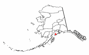
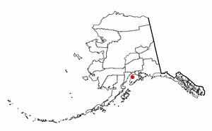
Kenai Peninsula Borough is a borough of the U.S. state of Alaska. As of the 2020 census, the population was 58,799, up from 55,400 in 2010. The borough seat is Soldotna, the largest city is Kenai, and the most populated community is the census-designated place of Kalifornsky.

<span class="mw-page-title-main">Anchor Point, Alaska</span> Census-designated place in Alaska, United States

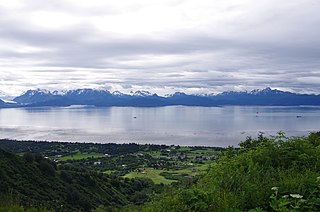
Anchor Point is an unincorporated community and census-designated place (CDP) in Kenai Peninsula Borough, in the U.S. state of Alaska. As of the 2010 census the population was 1,930, up from 1,845 in 2000. The community is located along the Sterling Highway, part of Alaska State Route 1. Anchor Point is the westernmost point in the North American highway system.

<span class="mw-page-title-main">Beluga, Alaska</span> Census-designated place in Alaska, United States

Beluga is a census-designated place (CDP) in Kenai Peninsula Borough, Alaska, United States. The population was 20 at the 2010 census, down from 32 in 2000.

<span class="mw-page-title-main">Cohoe, Alaska</span> Census-designated place in Alaska, United States

Cohoe (Dena'ina: Qughuhnaz’ut) is a census-designated place (CDP) in Kenai Peninsula Borough, Alaska, United States. At the 2010 census the population was 1,364, up from 1,168 in 2000.

<span class="mw-page-title-main">Cooper Landing, Alaska</span> Census-designated place in Alaska, United States

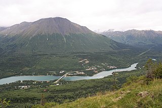
Cooper Landing is a census-designated place (CDP) in Kenai Peninsula Borough, Alaska, United States, about 100 miles (160 km) south of Anchorage, at the outlet of Kenai Lake into the Kenai River. The town was first settled in the 19th century by gold and mineral prospectors, and has become a popular summer tourist destination thanks to its scenic location and proximity to the salmon fishery of the Kenai River and Russian River. As of the 2010 census, the population in Cooper Landing was 289, down from 369 in 2000.

<span class="mw-page-title-main">Crown Point, Alaska</span> Census-designated place in Alaska, United States

Crown Point is a census-designated place (CDP) in Kenai Peninsula Borough, Alaska, United States. The population was 74 at the 2010 census. Land access to this area is by either the Alaska Railroad or the Seward Highway.

<span class="mw-page-title-main">Fox River, Alaska</span> Census-designated place in Alaska, United States

Fox River is a census-designated place (CDP) in Kenai Peninsula Borough, Alaska, United States. At the 2010 census the population was 685, up from 616 in 2000. It was first reported by the U.S. Geological Survey in 1895. The Fox River, which flows by the CDP, might have been named for Theodore Fox, a local mining magnate.

<span class="mw-page-title-main">Funny River, Alaska</span> Census-designated place in Alaska, United States

Funny River is a census-designated place (CDP) in Kenai Peninsula Borough, Alaska, United States. At the 2010 census the population was 877, up from 636 in 2000.

<span class="mw-page-title-main">Hope, Alaska</span> Census-designated place in Alaska, United States

Hope is a census-designated place (CDP) in Kenai Peninsula Borough in the U.S. state of Alaska. It is eighty-seven miles south from Anchorage. As of the 2010 census the population was 192, up from 137 in 2000.

<span class="mw-page-title-main">Kalifornsky, Alaska</span> Census-designated place in Alaska, United States

Kalifornsky is a census-designated place (CDP) in Kenai Peninsula Borough, Alaska, United States. The population was 8,487 at the 2020 census, up from 7,850 in 2010. It is the most populated locality in the borough.

<span class="mw-page-title-main">Kasilof, Alaska</span> Census-designated place in Alaska, United States

Kasilof is a census-designated place (CDP) in Kenai Peninsula Borough, Alaska, United States. At the 2020 census the population was 525, down from 549 in 2010.

<span class="mw-page-title-main">Lowell Point, Alaska</span> Census-designated place in Alaska, United States

Lowell Point is a census-designated place (CDP) in Kenai Peninsula Borough, Alaska, United States, just outside Seward. At the 2010 census the population was 80, down from 92 in 2000.

<span class="mw-page-title-main">Moose Pass, Alaska</span> Census-designated place in Alaska, United States

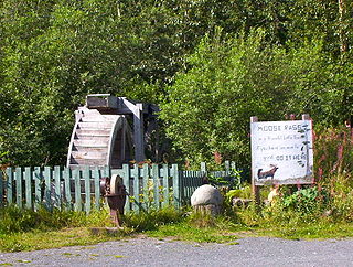
Moose Pass is a census-designated place (CDP) in Kenai Peninsula Borough, Alaska, United States. The population was 219 at the 2010 census, up from 206 in 2000.

<span class="mw-page-title-main">Nikiski, Alaska</span> Census-designated place in Alaska, United States

Nikiski is a census-designated place (CDP) in Kenai Peninsula Borough, Alaska, United States. The population was 4,456 at the 2020 census, down from 4,493 in 2010.

<span class="mw-page-title-main">Primrose, Alaska</span> Census-designated place in Alaska, United States

Primrose is a census-designated place (CDP) in Kenai Peninsula Borough, Alaska, United States. The population was 78 at the 2010 census, down from 93 at the 2000 census. Primrose is one of a number of small communities located north of Seward along the Seward Highway.

Ridgeway is a census-designated place (CDP) in Kenai Peninsula Borough, Alaska, United States. At the 2020 census the population was 2,136, up from 2,022 in 2010.

<span class="mw-page-title-main">Seward, Alaska</span> City in Alaska, United States

Seward is an incorporated home rule city in Alaska, United States. Located on Resurrection Bay, a fjord of the Gulf of Alaska on the Kenai Peninsula, Seward is situated on Alaska's southern coast, approximately 120 miles (190 km) by road from Alaska's largest city, Anchorage.

<span class="mw-page-title-main">Sterling, Alaska</span> Census-designated place in Alaska, United States

Sterling is a census-designated place (CDP) in Kenai Peninsula Borough, Alaska, United States. At the 2020 census the population was 5,918, up from 5,617 in 2010. Sterling is the tenth-most populated CDP in Alaska.

<span class="mw-page-title-main">Sunrise, Alaska</span> Archaeological site in Alaska, United States

Sunrise is a census-designated place (CDP) in Kenai Peninsula Borough, Alaska, United States. The population was 18 at the 2010 census, unchanged from 2000.

<span class="mw-page-title-main">Tyonek, Alaska</span> Census-designated place in Alaska, United States

Tyonek or Present / New Tyonek is a census-designated place (CDP) in Kenai Peninsula Borough in the U.S. state of Alaska. As of the 2020 census the population was 152, down from 171 in 2010. In 1973, the community formed the Tyonek Native Corporation (TNC) under the Alaska Native Claims Settlement Act and is federally recognized.

References

  1. Poux, Sabine. "Micciche wins Kenai Peninsula Borough mayor's race". Alaska Public Media. Alaska Public Media. Retrieved March 23, 2023.
  2. "2020 U.S. Gazetteer Files". United States Census Bureau. Retrieved October 29, 2021.
  3. "Bear Creek AK ZIP Code". zipdatamaps.com. 2023. Retrieved June 16, 2023.
  4. "2020 Census Data - Cities and Census Designated Places" (Web). State of Alaska, Department of Labor and Workforce Development. Retrieved October 31, 2021.
  5. 1 2 "Geographic Identifiers: 2010 Demographic Profile Data (G001): Bear Creek CDP, Alaska". U.S. Census Bureau, American Factfinder. Retrieved January 10, 2019.[ dead link ]
  6. U.S. Geological Survey Geographic Names Information System: Bear Creek, Alaska
  7. "US Gazetteer files: 2010, 2000, and 1990". United States Census Bureau. February 12, 2011. Retrieved April 23, 2011.
  8. U.S. Geological Survey Geographic Names Information System: Woodrow, Kenai Peninsula, Alaska
  9. "U.S. Decennial Census". Census.gov. Retrieved June 6, 2013.
  10. "Bear Creek CDP, Kenai Peninsula Borough, Alaska Population and Demographics". U.S Population. U.S Population. Retrieved March 22, 2023.
  11. "Bear Creek, AK". Data USA. Data USA. Retrieved March 22, 2023.

60°10′34″N149°23′42″W / 60.17606°N 149.395066°W / 60.17606; -149.395066