Arctic exploration

Last updated

The 10 degC (50 degF) mean isotherm in July line (in red) commonly defines the border of the Arctic region. Arctic.svg
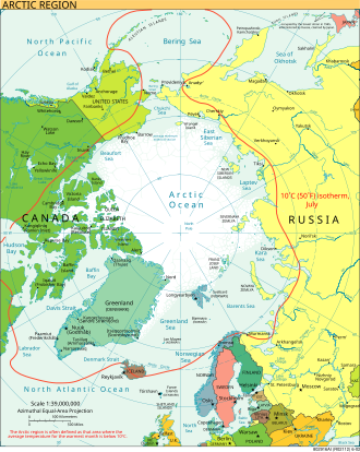
The 10 °C (50 °F) mean isotherm in July line (in red) commonly defines the border of the Arctic region.

Arctic exploration is the physical exploration of the Arctic region of the Earth. It refers to the historical period during which mankind has explored the region north of the Arctic Circle. Historical records suggest that humankind have explored the northern extremes since 325 BC, when the ancient Greek sailor Pytheas reached a frozen sea while attempting to find a source of the metal tin. [1] Dangerous oceans and poor weather conditions often fetter explorers attempting to reach polar regions, and journeying through these perils by sight, boat, and foot has proven difficult. [1]

Contents

Ancient history

Indo-European Hypothesis

A controversial hypothesis, often regarded as pseudohistory, sets the home of the mythical people Hyperboreans in the Arctic. The scientist and author John G. Bennett talked about it in his research paper "The Hyperborean Origin of the Indo-European Culture" (1963). [2] The theory was originally put forth by William F. Warren, the first President of Boston University, in his Paradise Found or the Cradle of the Human Race at the North Pole. Later, Indian independence activist Bal Gangadhar Tilak resurrected Warren's theory in his The Arctic Home in the Vedas (1903), which was dedicated to philologist and indologist Max Müller, with whom Tilak had shared ideas before the book was completed. [3] Austro-Hungarian ethnologist Karl Penka also discussed the same idea in his Origins of the Aryans (1883). [3] Tilak's theory was popularized by Russian nationalists, due to the work of Soviet historian and ethnographer Natalya Romanovna Guseva [4] and Soviet ethnographer S.V Zharnikova, [5] who argued for a northern Urals Arctic homeland of the Indo-Aryan and Slavic people. [6]

Hindu nationalist Madhavrao Sadashivrao Golwalkar also supported and was inspired by Tilak's idea. [7] In his famous 1939 publication We or Our Nationhood Defined, he stated that "Undoubtedly [...] we Hindus have been in undisputed and undisturbed possession of this land for over eight or even ten thousand years before the land was invaded by any foreign race." [8]

Ancient Greek historian and geographer Herodotus said that the Hyperboreans lived beyond the Massagetae and Issedones. Since these are both Central Asian peoples, one could speculate that his Hyperboreans lived in Siberia. In his twelve labours, Heracles sought the golden-antlered hind of Artemis in Hyperborea. Since the reindeer is the only deer species of which females bear antlers, this would suggest an arctic or subarctic region. Scholar James D. P. Bolton instead located the Issedones people on the south-western slopes of the Altay mountains, which led his colleague Carl P. Ruck to place Hyperborea beyond the Dzungarian Gate into the northern part of the Xinjiang region, adding that the Hyperboreans were probably Chinese. [9]

Ancient Greece

Some scholars believe that the first attempts to penetrate the Arctic Circle can be traced to ancient Greece and the sailor Pytheas, a contemporary of Aristotle and Alexander the Great, who, in 325 BC, attempted to find the source of the tin that would sporadically reach the Greek colony of Massilia (now Marseille) on the Mediterranean coast. [1] Sailing past the Pillars of Hercules, he reached Brittany and then Cornwall, eventually circumnavigating the British Isles. From the local population, he heard news of the mysterious land of Thule, even farther to the north. After six days of sailing, he reached land at the edge of a frozen sea (described by him as "curdled"), and described what is believed to be the aurora and the midnight sun. Some historians claim that this new land of Thule was either the Norwegian coast or the Shetland Islands based on his descriptions and the trade routes of early British sailors. While no one knows exactly how far Pytheas sailed, he may have crossed the Arctic Circle. Nevertheless, his tales were regarded as fantasy by later Greek and Roman authorities, such as the geographer Strabo. [10]

The Middle Ages

Viking sailors reached the White Sea, Greenland and North America Vikings-Voyages.png
Viking sailors reached the White Sea, Greenland and North America

Naddodd is said to have encountered Iceland when he lost his route due to harsh conditions when sailing from Norway to the Faroe Islands in the 860's. [11] In the 10th century, Gunnbjörn Ulfsson got lost in a storm and ended up within sight of the Greenland coast. His report spurred Erik the Red, an outlawed chieftain, to establish a settlement there in 985. While they flourished initially, these settlements eventually petered out until about 1450. Initially this abandonment of the colony was credited to the Little Ice Age but that has been disputed by recent studies which suggest there were more complex factors at play. [12]

Greenland's early settlers sailed westward, in search of better pasturage and hunting grounds. Modern scholars debate the precise location of the new lands of Vinland, Markland, and Helluland that they discovered. [13]

The Scandinavian peoples also pushed farther north into their own peninsula by land and by sea. As early as 880, the Viking Ohthere of Hålogaland rounded the Scandinavian Peninsula and sailed to the Kola Peninsula and the White Sea. The Pechenga Monastery on the north of Kola Peninsula was founded by Russian monks in 1533; from their base at Kola, the Pomors explored the Barents Region, Spitsbergen, and Novaya Zemlya  all of which are in the Arctic Circle. They also explored north by boat, discovering the Northern Sea Route, as well as penetrating to the trans-Ural areas of northern Siberia. Pomors founded the settlement of Mangazeya east of the Yamal Peninsula in the early 16th century. [14] In 1648 the Cossack Semyon Dezhnyov opened the now famous Bering Strait between America and Asia.

Russian settlers and traders on the coasts of the White Sea, the Pomors, had been exploring parts of the northeast passage as early as the 11th century. By the 17th century they established a continuous sea route from Arkhangelsk as far east as the mouth of Yenisey. This route, known as Mangazeya seaway, after its eastern terminus, the trade depot of Mangazeya, was an early precursor to the Northern Sea Route.

Age of Discovery

Gerardus Mercator's map of the North Pole (1606) 1606 Mercator Hondius Map of the Arctic (First Map of the North Pole) - Geographicus - NorthPole-mercator-1606.jpg
Gerardus Mercator’s map of the North Pole (1606)

Exploration to the north of the Arctic Circle in the Renaissance was both driven by the rediscovery of the Classics and the national quests for commercial expansion, and hampered by limits in maritime technology, lack of stable food supplies, and insufficient insulation for the crew against extreme cold.

Renaissance advancements in cartography

Patent from King Henry VII, authorizing John Cabot and his sons to explore new lands in the west John Cabot patent.jpg
Patent from King Henry VII, authorizing John Cabot and his sons to explore new lands in the west

A seminal event in Arctic exploration occurred in 1409, when Ptolemy's Geographia was translated into Latin, thereby introducing the concepts of latitude and longitude into Western Europe. [15] As a result navigators were better able to chart their positions. The Inventio Fortunata , a lost book, describes in a summary written by Jacobus Cnoyen but only found in a letter from Gerardus Mercator, voyages as far as the North Pole. [16] One widely disputed claim is that two brothers from Venice, Niccolo and Antonio Zeno, allegedly made a map of their journeys to that region, which were published by their descendants in 1558. [17]

Northwest Passage

The Northwest Passage Northwest passage.jpg
The Northwest Passage

The Northwest Passage connects the Atlantic and Pacific Oceans via the Arctic Ocean. Since the discovery of the American continent was the product of the search for a route to Asia, exploration around the northern edge of North America continued for the Northwest Passage. John Cabot's initial failure in 1497 to find a Northwest Passage across the Atlantic led the British to seek an alternative route to the east.

Interest re-kindled in 1564 after Jacques Cartier's discovery of the mouth of the Saint Lawrence River. Martin Frobisher had formed a resolution to undertake the challenge of forging a trade route from England westward to India. From 1576 to 1578, he took three trips to what is now the Canadian Arctic in order to find the passage. Frobisher Bay is named after him. In July 1583, Sir Humphrey Gilbert, who had written a treatise on the discovery of the passage and was a backer of Frobisher's, claimed the territory of Newfoundland for the English crown.

In 1585, under the employ of Elizabeth I, the English explorer John Davis entered Cumberland Sound, Baffin Island. Davis rounded Greenland before dividing his four ships into separate expeditions to search for a passage westward. Though he was unable to pass through the icy Arctic waters, he reported to his sponsors that the passage they sought is "a matter nothing doubtfull [ sic ]," [18] and secured support for two additional expeditions, reaching as far as Hudson Bay.

Though England's efforts were interrupted in 1587 because of the Anglo-Spanish War, Davis's favorable reports on the region and its people would inspire explorers in the coming century. [19] In 1609, while in the service of the Dutch East India Company, the English explorer Henry Hudson sailed up what is now called the Hudson River in search of the Passage; he reached present-day Albany, New York, before giving up. He later explored further north into the Arctic and Hudson Bay for the Passage. [20] [21]

The Northeast Passage

Jan Janssonius's map of the "Poli Arctici" from 1644. Arctic 1644.jpg
Jan Janssonius’s map of the "Poli Arctici" from 1644.

The Northeast Passage is a broad term for any route lying above the Eurasian continent and stretching between the waters north of the Norwegian Sea to the Bering Strait. The "Northern Sea Route" is defined as a specific portion of such routes. The Northern Sea Route (capitalized) as currently officially defined by Russian Federation law includes shipping lanes falling within Russia's EEZ and extending from the Kara Sea to the Bering Strait along the Russian northern coast.

The idea to explore this region was initially economic, and was first put forward by Russian diplomat Dmitry Gerasimov in 1525. The entire route laid in Arctic waters and parts and was usually covered in ice, making it a very perilous journey. [22]

In the mid-16th century, John Cabot's son Sebastian helped organize just such an expedition, led by Sir Hugh Willoughby and Richard Chancellor. Willoughby's crew was shipwrecked off the Kola Peninsula, where they eventually died of scurvy. Chancellor and his crew made it to the mouth of the Dvina River and the town of Arkhangelsk, where they were met by a delegation from the Tsar, Ivan the Terrible. Brought back to Moscow, he launched the Muscovy Company, promoting trade between England and Russia. This diplomatic course allowed British Ambassadors such as Sir Francis Cherry the opportunity to consolidate geographic information developed by Russian merchants into maps for British exploration of the region. Some years later, Steven Borough, the master of Chancellor's ship, made it as far as the Kara Sea, when he was forced to turn back because of icy conditions. [23]

Spitsbergen and Svalbard during the Golden Age of Dutch exploration and discovery (ca. 1590s-1720s). Portion of 1599 map of Arctic exploration by Willem Barentsz. Spitsbergen, here mapped for the first time, is indicated as "Het Nieuwe Land" (Dutch for "the New Land"), center-left. This is a typical map from the Golden Age of Netherlandish cartography. Barentsz arctic map.jpg
Spitsbergen and Svalbard during the Golden Age of Dutch exploration and discovery (ca. 1590s–1720s). Portion of 1599 map of Arctic exploration by Willem Barentsz. Spitsbergen, here mapped for the first time, is indicated as "Het Nieuwe Land" (Dutch for "the New Land"), center-left. This is a typical map from the Golden Age of Netherlandish cartography.
A Dutch map of Jan Mayen during the Golden Age of Dutch exploration and discovery (ca. 1590s-1720s). The Dutch were the first to undisputedly explore and chart coastlines of Jan Mayen and the Svalbard archipelago in the Arctic Ocean. C.G. Zorgdragers Bloeyende opkomst der aloude en hedendaagsche Groenlandsche visschery - no-nb digibok 2014010724007-V5.jpg
A Dutch map of Jan Mayen during the Golden Age of Dutch exploration and discovery (ca. 1590s–1720s). The Dutch were the first to undisputedly explore and chart coastlines of Jan Mayen and the Svalbard archipelago in the Arctic Ocean.

Western parts of the passage were simultaneously being explored by Northern European countries like England, the Netherlands, Denmark and Norway, looking for an alternative seaway to China and India. Most notable is the 1596 expedition led by Dutch navigator Willem Barentsz who discovered Spitsbergen and Bear Island.

Fearing English and Dutch penetration into Siberia, Russia closed the Mangazeya seaway in 1619. Pomor activity in Northern Asia declined and the bulk of exploration in the 17th century was carried out by Siberian Cossacks, sailing from one river mouth to another in their Arctic-worthy kochs . In 1648 the most famous of these expeditions, led by Fedot Alekseev and Semyon Dezhnev, sailed east from the mouth of Kolyma to the Pacific and doubled the Chukchi Peninsula, thus proving that there was no land connection between Asia and North America. [24] Eighty years after Dezhnev, in 1728, another Russian explorer, Danish-born Vitus Bering on Sviatoy Gavriil made a similar voyage in reverse, starting in Kamchatka and going north to the passage that now bears his name (Bering Strait). It was Bering who gave their current names to Diomede Islands, discovered and first described by Dezhnev. [25]

It was not until in 1878 that Finnish-Swedish explorer Adolf Erik Nordenskiöld made the first complete passage of the North East Passage from west to east, in the Vega expedition. The ship's captain on this expedition was Lieutenant Louis Palander of the Swedish Royal Navy.

Northwest Passage

Sailing Ship in Arctic Regions Sailing Ship in Arctic Regions.tiff
Sailing Ship in Arctic Regions
Roald Amundsen led the first expedition to reach the South Pole, was the first person to reach both poles, and was the first person to traverse the Northwest Passage. Roald Amundsen2.jpg
Roald Amundsen led the first expedition to reach the South Pole, was the first person to reach both poles, and was the first person to traverse the Northwest Passage.

In the first half of the 19th century, parts of the Northwest Passage were explored separately by a number of different expeditions, including those by John Ross, William Edward Parry, James Clark Ross; and overland expeditions led by John Franklin, George Back, Peter Warren Dease, Thomas Simpson, and John Rae. Sir Robert McClure was credited with the discovery of the Northwest Passage by sea in 1851 [26] when he looked across M'Clure Strait from Banks Island and viewed Melville Island. However, the strait was blocked by young ice at this point in the season, and not navigable to ships. [27] The only usable route, linking the entrances of Lancaster Sound and Dolphin and Union Strait was first used by John Rae in 1851. Rae used a pragmatic approach of traveling by land on foot and dog sled, and typically employed less than ten people in his exploration parties. [28]

The Northwest Passage was not completely conquered by sea until 1906, when the Norwegian explorer Roald Amundsen, who had sailed just in time to escape creditors seeking to stop the expedition, completed a three-year voyage in the converted 47-ton herring boat Gjøa . At the end of this trip, he walked into the city of Eagle, Alaska, and sent a telegram announcing his success. His route was not commercially practical; in addition to the time taken, some of the waterways were extremely shallow. [29]

Knud Rasmussen (1879–1933) led several Arctic expeditions. He grew up in Greenland speaking Greenlandic and Danish, and has been called the "father of Eskimology" [30] and was the first Greenlander of Inuit and European descent to cross the Northwest Passage via dog sled. [31] Rasmussen and his friend Peter Freuchen participated in seven Thule Expeditions, named after ultima Thule , and wrote numerous books on their Arctic experiences.

The North Pole

Robert Peary and sledge party with flags at North Pole. Peary has been claimed to be the first person to reach the North Pole. Peary Sledge Party and Flags at the Pole.jpg
Robert Peary and sledge party with flags at North Pole. Peary has been claimed to be the first person to reach the North Pole.

On April 6, 1909, Robert Peary claimed to be the first person in recorded history to reach the North Pole [26] (although whether he actually reached the Pole is disputed). [1] [32] He traveled with the aid of dogsleds and three separate support crews who turned back at successive intervals before reaching the Pole. Many modern explorers, including Olympic skiers using modern equipment, contend that Peary could not have reached the pole on foot in the time he claimed.

A number of previous expeditions set out with the intention of reaching the North Pole but did not succeed; that of British naval officer William Edward Parry in 1827, the tragic American Polaris expedition under Charles Francis Hall in 1871, the ill-fated Jeannette Expedition commanded by US Navy Lieutenant Commander George W. De Long in 1879, and the Norwegian Fram expedition of Fridtjof Nansen in 1895. American Frederick Cook claimed to have reached the North Pole in 1908, but this has not been widely accepted. [33]

On May 9, 1926, Americans Richard E. Byrd and Floyd Bennett claimed to have flown over the North Pole in a Fokker F.VIIa/3m Tri-motor monoplane. However, their claim to have reached the Pole is disputed. [34]

The crew of the airship Norge (including Roald Amundsen and the American sponsor Lincoln Ellsworth) flew over the Pole on May 12, 1926. This is the first undisputed sighting of the Pole. Norge was designed and piloted by the Italian Umberto Nobile, who overflew the Pole a second time on May 24, 1928. Nobile's second trip was in the airship Italia that ran into a storm on the return trip and crashed on the ice. Survivors were eventually recovered. Amundsen disappeared, with the crew of his sea plane, during the rescue operations.

The first people to have without doubt walked on the North Pole were the Soviet party of 1948 under the command of Alexander Kuznetsov, who landed their aircraft nearby and walked to the pole. [35]

On August 3, 1958, the American submarine USS Nautilus (SSN-571) reached the North Pole without surfacing. It then proceeded to travel under the entire Polar ice cap. On March 17, 1959, the USS Skate (SSN-578) surfaced on the North Pole and dispersed the ashes of explorer Sir Hubert Wilkins. These journeys were part of military explorations stimulated by the Cold War context.

On April 19, 1968, Ralph Plaisted reached the North Pole via snowmobile, the first surface traveler known with certainty to have done so. His position was verified independently by a US Air Force meteorological overflight. In 1969 Wally Herbert, on foot and by dog sled, became the first man to reach the North Pole on muscle power alone, on the 60th anniversary of Robert Peary's famous but disputed expedition.

The first persons to reach the North Pole on foot (or skis) and return with no outside help, no dogs, airplanes, or re-supplies were Richard Weber (Canada) and Misha Malakhov (Russia) in 1995. No one has completed this journey since.

U.S. Air Force Lieutenant Colonel Joseph O. Fletcher and Lieutenant William Pershing Benedict landed a plane at the Pole on May 3, 1952, accompanied by the scientist Albert P. Crary. [36]

On 2 May 2007, BBC's Top Gear reached the 1996 position of the magnetic north pole ( 78°35.7′N104°11.9′W / 78.5950°N 104.1983°W / 78.5950; -104.1983 (Magnetic North Pole 1996) ) in a modified Toyota Hilux.

On 2 August 2007, during Arktika 2007 Russian crewed submersibles were the first to descend to the seabed below the pole.

On April 26, 2009, Vassily Elagin, Afanassi Makovnev, Vladimir Obikhod, Sergey Larin, Alexey Ushakov, Alexey Shkrabkin and Nikolay Nikulshin after 38 days and over 2,000 km (1,200 mi) (starting from Sredniy Island, Severnaya Zemlya) drove two Russian built cars "Yemelya-1" and "Yemelya-2" to the North Pole.

See also

Notes

  1. 1 2 3 4 "Arctic, The". Columbia Encyclopedia, Sixth Edition. Columbia University Press. 2004. Archived from the original on 4 January 2013. Retrieved 19 October 2006.
  2. Bennett, John G (December 1963). "The Hyperborean Origin of the Indo-European Culture". Systematics. 1 (3). Archived from the original on 14 September 2011.
  3. 1 2 Godwin, Jocelyn (1993). Arktos: the Polar Myth in Science, Symbolism, and Nazi Survival. London: Thames & Hudson. pp. 32–50. ISBN   0500277133.
  4. Shnirelman (2007), pp. 38–39.
  5. Shnirelman (2007), p. 40.
  6. Shnirelman (2007), pp. 38–41.
  7. Schaeffer, Carol (2018). "Alt-Reich. The unholy alliance between India and the new global wave of white supremacy". The Caravan: 42.
  8. Pandey, Gyanendra (2006). Routine Violence: Nations, Fragments, Histories. Stanford University Press. p. 103.
  9. Wasson, R.G.; Kramrisch, Stella; Ott, Jonathan; et al. (1986), Persephone's Quest – Entheogens and the origins of Religion, Yale University Press, pp. 227–230, ISBN   0300052669
  10. Roller, Duane (2018). A Historical and Topographical Guide to the Geography of Strabo. Cambridge University Press. ISBN   978-1316850701.
  11. Hoare, J. Douglas (1906). Arctic Exploration . Retrieved 31 December 2021. Occasionally one of them would happen on a new country by accident, just as Naddod the Viking happened upon Iceland in 861 by being driven there by a gale while on his way to the Faroe Islands.
  12. Mooney, Chris (4 December 2015). "Vikings' mysterious abandonment of Greenland was not due to climate change, study suggests". The Washington Post . Retrieved 31 December 2021.
  13. Foster, Aidan (2012). "Hierophanies in the Vinland Sagas: Images of a New World" (PDF). Culture and Cosmos. 16 (1): 131–138. doi:10.46472/CC.01216.0223 . Retrieved 31 December 2021.
  14. Klimenko, Vladimir (15 October 2015). "Thousand-year history of northeastern Europe exploration in the context of climatic change: Medieval to early modern times". The Holocene. 26 (3): 365–379. doi:10.1177/0959683615609745. S2CID   133255837 . Retrieved 1 January 2022.
  15. "Ptolemy's Geography". www.ibiblio.org.
  16. Taylor, E.G.R. (1956), "A Letter Dated 1577 from Mercator to John Dee", Imago Mundi, 13: 56–68, doi:10.1080/03085695608592127
  17. Oleson, T.J. (1979) [1966]. "Zeno, Nicolò". In Brown, George Williams (ed.). Dictionary of Canadian Biography . Vol. I (1000–1700) (online ed.). University of Toronto Press.
  18. Davis, John (1880). The Voyages and Works of John Davis, the Navigator. Hakluyt Society. p. 20. Retrieved 1 January 2022.
  19. Small, Margaret (2013). "From Thought to Action: Gilbert, Davis, And Dee's Theories behind the Search for the Northwest Passage". The Sixteenth Century Journal. 44 (4): 1041–1058. ISSN   0361-0160. JSTOR   24246301 . Retrieved 1 January 2022.
  20. Abacuk Pricket (1625). "Excerpt from A Larger Discourse of the Same Voyage". Chass.utoronto.ca. Archived from the original on 24 August 2007. Retrieved 19 February 2011.
  21. Neatby, L. H. (1979) [1966]. "Hudson, Henry". In Brown, George Williams (ed.). Dictionary of Canadian Biography . Vol. I (1000–1700) (online ed.). University of Toronto Press.
  22. Degroot, Dagomar (15 October 2015). "Testing the Limits of Climate History: The Quest for a Northeast Passage during the Little Ice Age, 1594–1597". The Journal of Interdisciplinary History. 45 (4): 459–484. doi:10.1162/JINH_a_00755. ISSN   1530-9169. S2CID   143663630 . Retrieved 1 January 2022.
  23. Wright, Helen Saunders (1910). The great white North: the story of polar exploration from the earliest times to the discovery of the Pole. The Macmillan co. pp.  7. helen wright great white north.
  24. Fisher, Raymond H (1981). The Voyage of Semen Dezhnev in 1648. The Hakluyt Society.
  25. Natasha Okhotina Lind; Peter Ulf Møller, eds. (2002). Under Vitus Bering's Command: New Perspectives on the Russian Kamchatka Expeditions (Beringiana, 1). Aarhus: Aarhus University Press. ISBN   8772889322.
  26. 1 2 "Arctic Exploration – Chronology". Quark Expeditions. 2004. Archived from the original on 11 September 2006. Retrieved 19 October 2006.
  27. Berton (1988), p. 219.
  28. Richards, R. L. (1990). "John Rae". In Halpenny, Francess G (ed.). Dictionary of Canadian Biography . Vol. XII (1891–1900) (online ed.). University of Toronto Press. Retrieved 20 October 2006.
  29. "Northwest Passage". The Canadian Encyclopedia . Historica Canada. 2006. Archived from the original on 2 January 2007. Retrieved 20 October 2006.
  30. Jean Malaurie, 1982.
  31. Alley, Sam. "Knud Johan Victor Rasmussen". Mankato: Minnesota State University. Archived from the original on 12 October 2010. Retrieved 23 November 2015.
  32. Wallace, Hugh N. (22 March 2015). "North Pole". The Canadian Encyclopedia . Historica Canada. Archived from the original on 30 September 2007. Retrieved 20 October 2006.
  33. See references on Frederick Cook for more information.
  34. Sale, Richard; Lewis, Madeleine (2005). Smithsonian Explorers: A Photographic History of Exploration . New York: Collins. p.  34. ISBN   978-0060819057.
  35. Concise chronology of approach to the poles, Scott Polar Research Institute. retrieved 2010-06-04.
  36. Simmons, George (1965). Target: Arctic; Men in the Skies at the Top of the World. Chilton Books. pp. 330–331. OCLC   486837.

Bibliography

Related Research Articles

<span class="mw-page-title-main">Northwest Passage</span> Sea route north of North America

The Northwest Passage (NWP) is the sea lane between the Atlantic and Pacific oceans through the Arctic Ocean, along the northern coast of North America via waterways through the Arctic Archipelago of Canada. The eastern route along the Arctic coasts of Norway and Siberia is accordingly called the Northeast Passage (NEP). The various islands of the archipelago are separated from one another and from Mainland Canada by a series of Arctic waterways collectively known as the Northwest Passages, Northwestern Passages or the Canadian Internal Waters.

<span class="mw-page-title-main">Roald Amundsen</span> Norwegian polar explorer (1872–1928)

Roald Engelbregt Gravning Amundsen was a Norwegian explorer of polar regions. He was a key figure of the period known as the Heroic Age of Antarctic Exploration.

<span class="mw-page-title-main">Bering Strait</span> Strait between Asia and North America

The Bering Strait is a strait between the Pacific and Arctic oceans, separating the Chukchi Peninsula of the Russian Far East from the Seward Peninsula of Alaska. The present Russia-United States maritime boundary is at 168° 58' 37" W longitude, slightly south of the Arctic Circle at about 65° 40' N latitude. The Strait is named after Vitus Bering, a Danish explorer in the service of the Russian Empire.

<span class="mw-page-title-main">John Rae (explorer)</span> Scottish explorer (1813–1893)

John Rae was a Scottish surgeon who explored parts of northern Canada. He was a pioneer explorer of the Northwest Passage.

<span class="mw-page-title-main">Northeast Passage</span> Shipping lane from the Kara Sea to the Pacific Ocean

The Northeast Passage is the shipping route between the Atlantic and Pacific Oceans, along the Arctic coasts of Norway and Russia. The western route through the islands of Canada is accordingly called the Northwest Passage (NWP).

<span class="mw-page-title-main">John Ross (Royal Navy officer)</span> Scottish naval officer and polar explorer (1777–1856)

Sir John Ross was a Scottish Royal Navy officer and polar explorer. He was the uncle of Sir James Clark Ross, who explored the Arctic with him, and later led expeditions to Antarctica.

Semyon Ivanovich Dezhnyov was a Russian explorer of Siberia and the first European to sail through the Bering Strait, 80 years before Vitus Bering did. In 1648 he sailed from the Kolyma River on the Arctic Ocean to the Anadyr River on the Pacific. His exploit was forgotten for almost a hundred years and Bering is usually given credit for discovering the strait that bears his name.

<span class="mw-page-title-main">Chukchi Sea</span> Marginal sea of the Arctic Ocean north of the Bering Strait

The Chukchi Sea, sometimes referred to as the Chuuk Sea, Chukotsk Sea or the Sea of Chukotsk, is a marginal sea of the Arctic Ocean. It is bounded on the west by the Long Strait, off Wrangel Island, and in the east by Point Barrow, Alaska, beyond which lies the Beaufort Sea. The Bering Strait forms its southernmost limit and connects it to the Bering Sea and the Pacific Ocean. The principal port on the Chukchi Sea is Uelen in Russia. The International Date Line crosses the Chukchi Sea from northwest to southeast. It is displaced eastwards to avoid Wrangel Island as well as the Chukotka Autonomous Okrug on the Russian mainland.

<span class="mw-page-title-main">Open Polar Sea</span> Hypothesized ice-free ocean surrounding the North Pole

The Open Polar Sea was a conjectured ice-free body of water that was believed to encircle the North Pole. Although this theory was widely accepted and served as a basis for many exploratory expeditions aimed at reaching the North Pole by sea or discovering a navigable route between Europe and the Pacific via the North Pole, it was ultimately proven to be untrue.

<span class="mw-page-title-main">James Clark Ross</span> British explorer and naval officer (1800–1862)

Sir James Clark Ross was a British Royal Navy officer and polar explorer known for his explorations of the Arctic, participating in two expeditions led by his uncle John Ross, and four led by William Edward Parry, and, in particular, for his own Antarctic expedition from 1839 to 1843.

<span class="mw-page-title-main">Dmitry Shparo</span> Russian Arctic explorer, endurance skier, and author

Dmitry Shparo is a Russian Arctic explorer and endurance skier. He is internationally known for twice reaching the North Pole on snow skis.

<span class="mw-page-title-main">David Scott Cowper</span> British yachtsman

David Scott Cowper is a British yachtsman, and was the first man to sail solo round the world in both directions and was also the first to successfully sail around the world via the Northwest Passage single-handed.

<span class="mw-page-title-main">Vladimir Voronin (captain)</span> Soviet naval explorer (1890–1952)

Vladimir Ivanovich Voronin was a Soviet Navy captain, born in Sumsky Posad, in the present Republic of Karelia, Russia. In 1932 he commanded the expedition of the Soviet icebreaker A. Sibiryakov which made the first successful crossing of the Northern Sea Route in a single navigation without wintering. This voyage was organized by the All-Union Arctic Institute.

<i>Fyodor Litke</i> (1909 icebreaker) Soviet icebreaker

The icebreaker Fyodor Litke was active in the Soviet era in the Arctic, until the late 1950s. It was built in 1909 in England for the Saint Lawrence River service and initially named CGC Earl Grey after Albert Grey, Governor General of Canada. After four years in Canada it was sold to the Russian government and eventually renamed Fyodor Litke in honour of the Arctic explorer Fyodor Petrovich Litke.

<i>Taymyr</i> (1909 icebreaker) Steam-powered icebreaker

Taymyr was an icebreaking steamer of 1,200 tons built for the Russian Imperial Navy at Saint Petersburg in 1909. It was named after the Taymyr Peninsula.

<span class="mw-page-title-main">Farthest North</span> Most northerly latitude reached by explorers before the conquest of the North Pole

Farthest North describes the most northerly latitude reached by explorers, before the first successful expedition to the North Pole rendered the expression obsolete. The Arctic polar regions are much more accessible than those of the Antarctic, as continental land masses extend to high latitudes and sea voyages to the regions are relatively short.

<span class="mw-page-title-main">Arctic policy of Russia</span> Russia and the Arctic

The Arctic policy of Russia is the domestic and foreign policy of the Russian Federation with respect to the Russian region of the Arctic. The Russian region of the Arctic is defined in the "Russian Arctic Policy" as all Russian possessions located north of the Arctic Circle. Approximately one-fifth of Russia's landmass is north of the Arctic Circle. Russia is one of five littoral states bordering the Arctic Ocean. As of 2010, out of 4 million inhabitants of the Arctic, roughly 2 million lived in arctic Russia, making it the largest arctic country by population. However, in recent years Russia's Arctic population has been declining at an excessive rate.

<i>Jeannette</i> expedition Failed 19th-century polar expedition

The Jeannetteexpedition of 1879–1881, officially called the U.S. Arctic Expedition, was an attempt led by George W. De Long to reach the North Pole by pioneering a route from the Pacific Ocean through the Bering Strait. The premise was that a temperate current, the Kuro Siwo, flowed northwards into the strait, providing a gateway to the hypothesized Open Polar Sea and thus to the pole.

The history of exploration by citizens or subjects of the Russian Federation, the Soviet Union, the Russian Empire, the Tsardom of Russia and other Russian predecessor states forms a significant part of the history of Russia as well as the history of the world. At 17,075,400 square kilometres (6,592,850 sq mi), Russia is the largest country in the world, covering more than a ninth of Earth's landmass. In the times of the Soviet Union and the Russian Empire, the country's share in the world's landmass reached 1/6. Most of these territories were first discovered by Russian explorers. Contiguous exploration in Eurasia and the building of overseas colonies in Russian America were some of the primary factors in Russian territorial expansion.