Viana do Castelo is a municipality and seat of the district of Viana do Castelo in the Norte Region of Portugal. The population in 2011 was 88,725, in an area of 319.02 km². The urbanized area of the municipality, comprising the city, has a population of approximately 36,148 inhabitants, although the extended densely populated region reaches surrounding municipalities like Caminha and Ponte de Lima with a population above 150,000 inhabitants. It is located on the Portuguese Way path, an alternative path of the Camino de Santiago, and at the mouth of the Lima river.
Afife is a civil parish located in the Portuguese municipality of Viana do Castelo. The population in 2011 was 1,632, in an area of 13.03 km2.
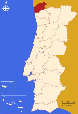
The Viana do Castelo District is a district located in the northwest of Portugal, bordered on the north by Spain (Galicia) and on the south by Braga District. It has an area of 2,255 km2 (871 sq mi) and a population of 252,011 (2006), for a density of 111.8 inhabitants/km2. The district capital is the city of Viana do Castelo.

Caminha is a municipality in the north-west of Portugal, 21 km north from Viana do Castelo, located in the Viana do Castelo District. The population in 2011 was 16,684, in an area of 136.52 km².
Vila Nova de Cerveira is a municipality in the district of Viana do Castelo in Portugal. The population in 2011 was 9,253, in an area of 108.47 km².
Sopo is a civil parish in the municipality of Vila Nova de Cerveira in the Portuguese northern district of Viana do Castelo. The population in 2011 was 557, in an area of 14.82 km².
Costa Verde is a tourist and coastal region of northwest Portugal, delimited by the river mouths of Minho in the north and Douro in the south.
The Battle of Vilanova took place on 17 September 1658 during the Portuguese Restoration War near the Fort of São Luis de Gonzaga, located south of Tui in the southern bank of the Minho River. A Spanish army commanded by the Governor of Galicia, Rodrigo Pimentel, Marquis of Viana, entered Portuguese territory and confronted a Portuguese army led by João Rodrigues de Vasconcelos e Sousa, 2nd Count of Castelo Melhor. The Spanish were victorious and proceeded over the following months to capture Monção, Salvaterra de Miño and other Portuguese strongholds.
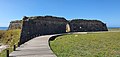
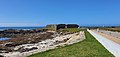
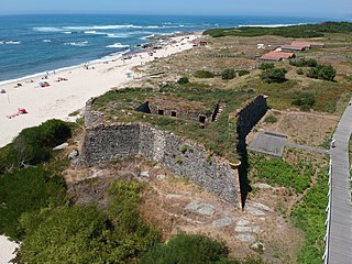
The Fort of Lagarteira is a medieval fort in the civil parish of Vila Praia de Âncora, municipality of Caminha in the Portuguese Norte, classified as a Property of Public Interest.

The Castle of Vila Nova de Cerveira is a medieval castle located in the civil parish of Vila Nova de Cerveira e Lovelhe, in the municipality of Vila Nova de Cerveira, Portuguese Viana do Castelo.
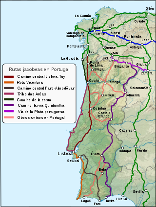
The Portuguese Way is the name of the Camino de Santiago pilgrimage routes starting in Portugal. It begins at Porto or Lisbon. From Porto, along the Douro River, pilgrims travel north crossing the five main rivers—the Ave, Cávado, Neiva, Lima and Minho—before entering Spain and passing through Pontevedra on the way to Santiago de Compostela.

The Fort Nossa Senhora da Ínsua, also known as Ínsua Fort, is located on Ínsua de Santo Isidro, in the parish of União das Freguesias de Moledo e Cristelo, in the municipality of Caminha, in the Viana do Castelo district, in Portugal.
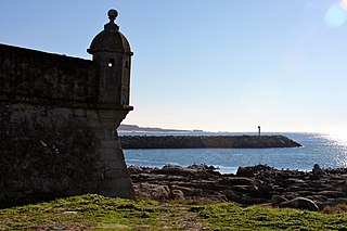
The Fort Santiago da Barra de Viana do Castelo also referred to as Castle Santiago da Barra and Castle São Tiago Maior da Barra is located in the parish of Santa Maria Maior, Monserrate, and Meadela, in the city of Viana do Castelo in Portugal.

the Fort of Cão, also referred to as Fortlet of Cão, is located in the place of Gelfa, by the Gelfa Beach and Gelfa Woodland, south of the village and parish of Âncora, in the municipality of Caminha, district of Viana do Castelo, in Portugal.
The Montedor Fort, also referred to as Montedor Fortlet or Paçô Fort, is located on Paçô beach, in the parish of Carreço, municipality of Viana do Castelo, in Portugal.

The Fort São João Baptista da Foz, is located in the parish of Foz do Douro, in the municipality and District of Porto, in Portugal.