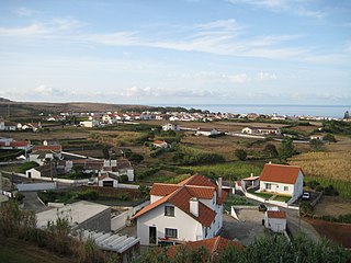
Vila do Porto is the single municipality, the name of the main town and one of the civil parishes on the island of Santa Maria, in the Portuguese archipelago of Azores. Its nearest neighbor, administratively, is the municipality of Povoação on the southern coast of São Miguel, and it is physically southwest of the islets of the Formigas. The population in 2021 was 5,408, in an area of 96.89 km2 (37.41 sq mi).

Angra do Heroísmo, or simply Angra, is a city and municipality on Terceira Island, Portugal, and one of the three capital cities of the Azores. Founded in 1478, Angra was historically the most important city in the Azores, as seat of the Bishop of the Azores, government entities, and having previously served as the capital city of Portugal during the Liberal Wars. The population in 2011 was 35,402, in an area of 239.00 km². It was classified as a World Heritage site by UNESCO in 1983.

Oeiras is a town and municipality in the western part of Lisbon metropolitan area, located within the Portuguese Riviera, in continental Portugal. The municipality is part of the urban agglomeration of Lisbon and the town of Oeiras is about 16 km from Lisbon downtown. The population in 2011 was 172,120 living in an area of 45.88 km2, making the municipality the fifth-most densely populated in Portugal.
Porto Salvo is a civil parish in the municipality of Oeiras, Portugal. It is situated to the north of the parish of Oeiras e São Julião da Barra, Paço de Arcos e Caxias. The population in 2011 was 15,157, in an area of 7.34 km2.

The Fort of Leça da Palmeira, or alternately the Castle of Matosinhos is a 17th-century fort located in civil parish of Leça da Palmeira, municipality of Matosinhos in the Greater Porto region of Portugal.

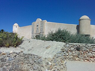
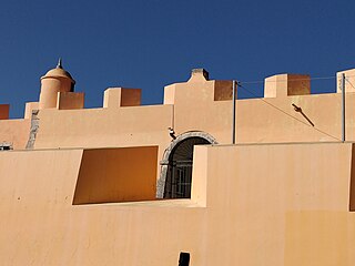
The Fort of São Sebastião de Caparica also known as the Tower of São Sebastião or Fortress of the Old Tower is a medieval fortification located in Monte da Caparica, civil parish of Caparica, in the municipality of Almada, in the Portuguese central region of Península de Setúbal.

The Fort of Guincho, also known as the Fort of Velas, is located at the edge of the Praia do Abano, along the southern edge of the coast of the civil parish of Alcabideche, in Cascais Municipality, Lisbon District, Portugal.. It was classified as Property of Public Interest by the national government on 29 September 1977, but today stands in a state of decay, even after studies to remodel the location as a visitors centre for the nearby Sintra-Cascais Nature Park.
The Fort of São Jorge is located on the coastal highway EN 247, near the Oitavos dunes, in the parish and municipality of Cascais, Lisbon district, Portugal. It was one of a series of forts stretching from the Tower of Belem close to Lisbon to Cabo da Roca. It is now a museum.

The Citadel of Cascais is a set of fortifications built between the 15th and 17th centuries to defend the Cascais coastline and River Tagus estuary and to protect against attacks on the capital of Portugal, Lisbon. The citadel incorporates three separate developments, the tower of Santo António de Cascais, the Fortress of Our Lady of Light, and the former Royal Palace area.

The São Julião da Barra Fort is the largest and most complete military defense complex in the Vauban style remaining in Portugal. It is located in São Julião da Barra, on the point of São Gião, in the parish of Oeiras e São Julião da Barra, Paço de Arcos e Caxias, Oeiras Municipality, Lisbon District. Considered in the past as the most important maritime fortification in the country, it had originally, together with the Fort of São Lourenço do Bugio, the role of controlling access to the port of Lisbon. It is currently the official residence of the Portuguese Minister of National Defence.

The Fort of Nossa Senhora da Guia is located in Cascais, Lisbon District in Portugal. It was built during the Portuguese Restoration War (1640-1668), becoming operational in 1646. The site, which preserves some parts of the fort, is now occupied by a maritime laboratory under control of the Faculty of Sciences of the University of Lisbon.

The Fort of Paimogo, also known as the Fort of Our Lady of the Angels of Paimogo, stands in a dominant position on Paimogo beach near the town of Lourinhã, Lisbon District in Portugal Constructed in 1674, it ceased to serve a military function in 1834 and is now under threat from coastal erosion. The fort presents an almost unique example of a fort from that period that has not undergone subsequent modification.

The Fort Nossa Senhora da Consolação, also known as Fort of Consolação Beach is located on the Atlantic coast of Portugal in the parish of Atouguia da Baleia, in the municipality of Peniche in Leiria District. It was built in 1645 during the Portuguese Restoration War on the initiative of D. Jerónimo de Ataíde, 6th Count of Atouguia and Lord of Peniche.

The Fort of São Bruno is situated on the estuary of the River Tagus in Caxias, Oeiras municipality, near Lisbon in Portugal. It was built in 1647 and became operational in 1649 as part of the construction of a line of forts to control access to Lisbon, which stretched from Cabo da Roca on the Atlantic coast to the Belém Tower near Lisbon. The fort is well preserved, following its original design, and is considered one of the most attractive examples of maritime military architecture on the Portuguese coast. It presently serves as the headquarters of the Associação Portuguesa dos Amigos dos Castelos.
The Fort of São João das Maias, also known as the Fort of Oeiras, is located on the right bank of the River Tagus estuary, in the municipality of Oeiras in the Lisbon District of Portugal. It was constructed between 1644 and 1653. Until 2010 it had been allowed to fall into a state of advanced degradation but in that year it was restored.

The Fort of Nossa Senhora das Mercês de Catalazete, also known as the Fort of Catalazete, is located on the right bank of the River Tagus estuary in the municipality of Oeiras in the Lisbon District of Portugal. The fort dates back to 1762, when a small battery was erected on a site between the Fort of São Julião da Barra and the Fort of Santo Amaro do Areeiro, with the purpose of strengthening the defence provided by those two forts.

The Fort of Santo Amaro do Areeiro, also known as the Forte Velho or Fort of Areeiro, is located on the right bank of the River Tagus in the municipality of Oeiras in the Lisbon District of Portugal. Construction began in 1647 under the direction of António Luís de Meneses and was completed in 1659.

The Forts of Ajuda are located in the parish of Bucelas, in the municipality of Loures in the Lisbon District of Portugal. Just a short distance apart, the Forts of Ajuda Grande (Big) and Ajuda Pequeno (Small) were built in 1810 as part of the Lines of Torres Vedras, which were defensive lines to protect the Portuguese capital Lisbon from invasion by the French during the Peninsular War (1807–14).

The Fort of Ponta da Bandeira, also known as Pau da Bandeira Fort ; Fort of Nossa Senhora da Penha de França ; the Fort of Registo ; or the Fort of Lagos is situated in the city of Lagos, in the Faro District of Portugal. It was built in the 17th century, as one of the main components of a system of maritime fortifications to defend the city, then headquarters of the military government of the Algarve. Significant restoration work has been carried out over the years and the fort is considered to be one of the best-preserved 17th century fortifications in the Algarve region.
The Fort of Trafaria is a fort in Portugal. Dating back to 1683, it has never been used in battle.

