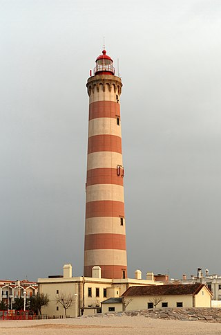
A lighthouse is a tower, building, or other type of physical structure designed to emit light from a system of lamps and lenses and to serve as a beacon for navigational aid, for maritime pilots at sea or on inland waterways.

Marblehead Lighthouse in Marblehead, Ohio, United States, is the oldest lighthouse in continuous operation on the American side of the Great Lakes. It has guided sailors safely along the rocky shores of Marblehead Peninsula since 1822, and is an active aid to navigation.
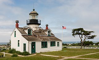
Point Pinos Lighthouse was lit on February 1, 1855, to guide ships on the Pacific Coast of California. It is the oldest continuously operating lighthouse on the West Coast of the United States and even the lens is original. Alcatraz Island Lighthouse preceded Point Pinos by eight months, but was replaced in 1909 by the expanding military prison. The Point Pinos Lighthouse is still an active United States Coast Guard aid to navigation. On-site museum exhibits and other lighthouse related functions are operated by the city of Pacific Grove, Monterey County, California. The lighthouse is surrounded by the Pacific Grove Municipal Golf Links.

The Garden Key Light, also known as the Tortuga Harbor Light, is located at Fort Jefferson, on Garden Key in the Dry Tortugas, Florida. The first lighthouse, started in 1824 and first lit in 1826, was a brick conical tower. The lighthouse and its outbuildings were the only structures on Garden Key until construction started on Fort Jefferson in 1846. Construction continued until 1861, but the fort was never completed.
Charity Island Light is a lighthouse on Big Charity Island in Lake Huron just off the coast of Au Gres, Northern Michigan.

Point Arena Light is a lighthouse in Mendocino County, California, United States, two miles (3 km) north of Point Arena, California. It is approximately 130 mi (210 km) north of San Francisco, in the Fort Point Group of lighthouses. The lighthouse features a small museum and gift shop. Guided tours of the light station as well as self-guided tours of the grounds are available daily.

The Mobile Point Range Lights were a series of lighthouses at the entrance to Mobile Bay, at Mobile Point on the tip of the Fort Morgan peninsula, near Mobile, Alabama, United States. The first lighthouse was built as a landfall light by June 1822 at a cost of $9,995. The lighthouse was a conical brick masonry tower, 40 feet (12 m) tall. It was first lit on 29 September 1822. Fort Morgan was built adjacent to the lighthouse in 1833. The lighthouse was joined by the 200-foot (61 m) Sand Island Light across the mouth of the bay, about 3 miles (4.8 km) away in 1858. This resulted in the Mobile Point Lighthouse being downgraded to a harbor light, at the same time a fourth order Fresnel lens was installed. A period photograph, taken prior to the American Civil War, shows two shorter masonry towers standing on the beach below the main tower, they served as range lights. The lighthouse was subsequently destroyed by cannonball fire in the Battle of Mobile Bay during the Civil War.

Concord Point Light is a 36-foot (11 m) lighthouse in Havre de Grace, Maryland. It overlooks the point where Susquehanna River flows into the Chesapeake Bay, an area of increasing navigational traffic when it was constructed in 1827. It is the northernmost lighthouse and the second-oldest tower lighthouse still standing on the bay.

Hurst Point Lighthouse is located at Hurst Point in the English county of Hampshire, and guides vessels through the western approaches to the Solent.

The Grand Island Harbor Rear Range Light is a lighthouse located off M-28 in Munising Township, Michigan. It is also known as the Bay Furnace Rear Range Light, Christmas Rear Range Light, or End of the Road Light. The corresponding front range light was replaced in 1968; the rear range light was listed on the National Register of Historic Places in 1990. It is no longer an active aid to navigation.
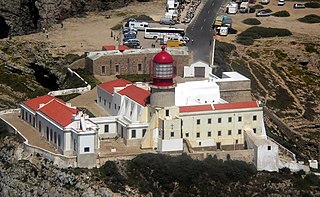
The Lighthouse of Cabo de São Vicente is a beacon/lighthouse located along the coastal peninsula of Sagres Point in the civil parish of Sagres, in the Portuguese municipality of the Vila do Bispo. Not to be confused with the Lighthouse of Ponta de Sagres, which is the located further to the edge of the extreme southwest cape of the civil parish, southwest of the Fortress of Sagres.

The Citadel of Cascais is a set of fortifications built between the 15th and 17th centuries to defend the Cascais coastline and River Tagus estuary and to protect against attacks on the capital of Portugal, Lisbon. The citadel incorporates three separate developments, the tower of Santo António de Cascais, the Fortress of Our Lady of Light, and the former Royal Palace area.

The Esteiro Lighthouse is an active Portuguese lighthouse located at Oeiras, about 10 km west of the centre of Lisbon, in parkland that also contains the National Stadium of Portugal. It is a rectangular masonry tower covered with white tiles. The south side has two red horizontal bands that serve as identification during daylight.
The Bugio Lighthouse is situated on an island in the estuary of the River Tagus on the Fort of São Lourenço do Bugio, about ten kilometres west of Lisbon. It falls under the municipality of Oeiras in Lisbon District.

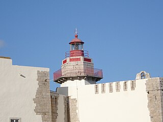
The São Julião Lighthouse is located in the fort of the same name, which is the largest sea defence structure in Portugal and is situated on a headland on the north bank of the River Tagus estuary in Oeiras, Lisbon District. It is a square masonry tower and the lantern is painted white, with a red dome.

The Fort of São Teodósio da Cadaveira, located at Estoril, Lisbon District, Portugal, is one of a series of more than a dozen fortresses built between 1642 and 1648 during the period of the Portuguese Restoration War with the purpose of forming a defensive line between the Tower of Belém on the RiverTagus and Cabo da Roca on the Atlantic coast, in order to defend the city of Lisbon. Its construction began in April 1642, and was concluded the following year. Its location permitted crossfire with the nearby Fort of Saint Anthony of Barra to protect the cove of the Poça Beach. It was named in honour of Teodósio, 9th Duke of Bragança, the first-born son of John IV of Portugal.

Berlenga lighthouse, also known as the Duke of Bragança Lighthouse, is a functioning lighthouse situated on the highest point of the granite island of Berlenga Grande, which is a nature reserve in the Atlantic Ocean, 10 kilometres west of the town of Peniche in the Leiria District of Portugal. Although planned for construction in the 18th century, work did not start until 1837 and it was completed in 1842.

The Fort of Cavalo Lighthouse is located in the Fort of São Teodósio da Ponta do Cavalo, on the western edge of Sesimbra, in the Setúbal District of Portugal. It started operations in 1896.
The Outão Lighthouse is located in the coastal Fort of Santiago do Outão, on the right bank of the narrow estuary of the River Sado, to the west of Setúbal in Portugal.

The Sines Lighthouse is located at Cabo de Sines, in Sines, in the Setúbal District of Portugal. It is a 22-metre high white cylindrical tower with a red beacon.


