The "Arusha" Region is named after the Arusha people, a Bantu ethnic group that originally migrated from Arusha Chini in Kilimanjaro Region around 400 years ago.[4]
History
Prehistory
Arusha Region is home to Laetoli and Olduvai Gorge national archaeological sites both locations with discoveries of prehistoric hominids.[5]
The second community to settle in the region is the Meru People, whom immigrated there from the Usambara Mountains in Tanga Region.[6] They settled on the southeastern slopes of the mountain and started to farm the land. The third wave of settlers were the Arusha people a subgroup of the Pare people migrated from Arusha Chini in Kilimanjaro Region. Some Parakuyo Masai in the west, who were the last group to immigrate to Arusha Region in the 1830s, assimilated into the Arusha community and influenced the Arusha into adopting the Masai language.[7]
In the 1880s a pandemic of rinderpest killed thousands of cattle and forced a large section of the Masai people in the west and integrated into Arusha agriculturally based society. In southeastern portion of the region in Karatu District and southern Ngorongoro District is the ancestral home to the Hadzabe People, who are the only surviving hunter gather communities left in the country.
Moreover, most of the Ngorongoro District, Monduli District and Longido District of the present area of Arusha Region are home to the Maasai, who immigrated from South Sudan, started moving southward around the 16th century CE toward Kenya, and finally reached the northwestern Arusha Region in the 1830s.[8] The Masai were the last precolonial community to settle in the present-day Arusha Region.
Colonial period
Prior to German arrival in 1895, the years between the 1880s to 1900, Arusha Region was plagued by rinderpest, Smallpox, droughts and famine that came after the devastating plagues.
The first German to visit Arusha territory was Kurt Johannes, and he was antagonistic towards the Arusha people and on occasion he survived an attack that cost the lives of two German missionaries in 1895. On 19 October 1896 he went to visit Chief Matunda and was attacked by Arusha warriors. Johannes survived the attack and returned to his post in Moshi and organised Chagga warriors for a retaliatory attack and defeated the WaArusha on 31 October 1896.[9]
Johannes then decided to conduct the scorched earth doctrine on the WaArusha people, leading to a famine and collapse of Arusha society. In 1899, Johannes forced the defeated Arusha warriors to build the German Boma next to today's Arusha Region Headquarters. The Arusha Region was under German military rule and in 1902, one hundred Afrikaners fleeing the Boer War in South Africa, are resettled in Arusha by German authorities, with each family given 1,000 hectares of land.[10]
For various reasons, many of the white settlers moved to Kenyan highlands or back to South Africa in a few years before the advent of World War I. During the great war, the British capture Arusha Region from the Germans in 1916.[11] They expelled all the Germans and confiscated their farms and redistributed the farms to Greek and British settlers.
The Meru and Arusha's Chagga wives were repatriated back to Kilimanjaro. The British started growing coffee in 1920. The administrative region of Arusha existed in 1922[12] while mainland Tanzania was a British mandate under the League of Nations and known as Tanganyika. In 1948, the area was in the Northern Province, and [13] shortly afterwards, the British appointed the first WaArusha community leader Chief Simeon Laiseri in 1948.
Post-Independence period
In 1966, under the newly independent Tanzanian government, Arusha was given its own regional status.[12] In 2002, Manyara Region was created and was split from Arusha Region. Portions of the former Arusha Region districts of Kiteto, Babati, Mbulu, Hanang, and a tiny piece of Monduli were incorporated into the Manyara Region. Arusha was the largest region in Tanzania from 1966 to 2002.[14]
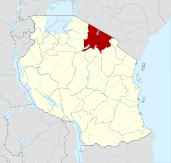
Geography
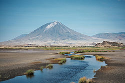
The Great Rift Valley runs through the middle of the region north-to-south. Oldonyo Lengai (Mountain of God in the Maasai language) is an active volcano to the north of the Ngorongoro Conservation Area. Altitudes throughout the region vary widely, but much of it ranges from 900 to 1,600 metres (3,000 to 5,200ft) in elevation.[15]
* - representing the west portion of the former Arumeru District ** - representing the east portion of the former Arumeru District
National parks, national monuments, and other sites
Western Arusha Region, Tanzania.Giraffes Arusha National Park, Arusha Region, Tanzania.Colobus guereza Mantelaffen at Arusha National Park, Arusha Region.Arusha Declaration Monument
The A-23 Arusha-Himo road runs east–west and enters the region near Kilimanjaro International Airport. It connects Arusha with Moshi and then Himo at the Kenyan border. This roads ends at its junction with the A-104 road in the center of Arusha.
Most overland travel is done by bus from the city of Arusha. Within the city and smaller towns, privately owned and operated dala-dalas (mini-buses) are used.
The region is landlocked, and there are no navigable rivers. The larger lakes in the Rift Valley are not used for transportation. The region is home to Lake Eyasi, Lake Natron, Lake Duluti, Lake Empakaai, and the Momella lakes.
The smaller Arusha Airport (Kisongo Airport) serves small, medium and personal planes mainly to popular tourist areas such as Serengeti National Park, Seronera, Ndutu, Zanzibar etc. Planes using Kisongo Airport include:
AMREF
Auric Air
Coastal Air
Flying Doctors
Grumeti Air
Other personal planes.
Precision Air
TFC
Notable persons from Arusha Region
Mrisho Sarakikya, The first Chief of the Tanzanian Defence Force.
The chief administrative officer of the region is the regional commissioner. Below is a table showing the regional commissioners serving the Arusha Region from 1962 to present:[22]
↑Col. Samuel Ndomba was reassigned to military duties in Dar es Salaam. Selasini, Edward (1–7 September 2007). "Zanzibar legislators visit Wazee Club". The Arusha Times. No.484. Archived from the original on 4 March 2016. Retrieved 4 September 2012.
↑Arusha Times Correspondent (17 December 2011 – 13 January 2012). "RC guarantees order and tranquility". The Arusha Times. No.695. Archived from the original on 23 September 2015. Retrieved 4 September 2012.{{cite news}}: |author= has generic name (help)
This page is based on this Wikipedia article Text is available under the CC BY-SA 4.0 license; additional terms may apply. Images, videos and audio are available under their respective licenses.


