
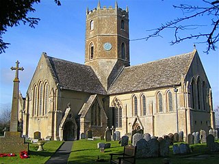
Reading Abbey is a large, ruined abbey in the centre of the town of Reading, in the English county of Berkshire. It was founded by Henry I in 1121 "for the salvation of my soul, and the souls of King William, my father, and of King William, my brother, and Queen Maud, my wife, and all my ancestors and successors." In its heyday the abbey was one of Europe's largest royal monasteries. The traditions of the Abbey are continued today by the neighbouring St James's Church, which is partly built using stones of the Abbey ruins.

Speen is a village and civil parish in West Berkshire, England. Centred 2 miles (3 km) north west of the largest town in the district, Newbury, Speen has clustered settlements, the largest of which is Speen village, which is contiguous with Newbury, and the others, buffered from the town by the A34 road, are Bagnor, Stockcross, Woodspeen and Marsh Benham. Its other land is an approximately even mixture of woodland and agricultural fields including hay meadows for livestock feed and pasture. The area varies greatly in elevation, having the Reading to Taunton Line alongside the north bank of the River Kennet as its southern boundary and both banks of the River Lambourn in its north with elevated ground in between. Benham Park in the south-west of the area is a listed landscape garden and house.

Sandhurst is a town and civil parish in the Bracknell Forest borough in Berkshire, England. It is in the south eastern corner of Berkshire, and is situated 32 miles (51 km) west-southwest of central London, 2.5 miles (4.0 km) north west of Camberley and 5 miles (8.0 km) south of Bracknell. Sandhurst is known worldwide as the location of the Royal Military Academy Sandhurst. Despite its close proximity to Camberley, Sandhurst is also home to a large and well-known out-of-town mercantile development. The site is named "The Meadows" and has a Tesco Extra hypermarket and a Marks & Spencer, two of the largest in the country. A large Next clothing and homeware store is open on the site of the old Homebase.
Uffington is a village and civil parish in Oxfordshire, about 4 miles (6.4 km) south of Faringdon and 6 miles (10 km) west of Wantage. The 2011 Census recorded the parish's population as 783. Lying within the historic county boundaries of Berkshire, in 1974 it was transferred for local government purposes to Oxfordshire under the Local Government Act 1972. Uffington is most commonly known for the Uffington White Horse hill figure on the Berkshire Downs in the south of the parish.

Finchampstead is a village and civil parish in the Wokingham Borough in the shire of Berkshire, England. Its northern extremity is 2 miles (3 km) south of Wokingham, 5 miles (8 km) west of Bracknell, 8 miles (13 km) south-east of Reading, and 34 miles (55 km) west of Central London. It is an affluent area, with the village ranking as Britain's 31st wealthiest. It has a high standard of living and is rated as one of the most desirable places to live in the United Kingdom.
Ufton Court is a manor house in the civil parish of Ufton Nervet, in the county of Berkshire, England.
Ashbury is a village and large civil parish at the upper end (west) of the Vale of White Horse. It was part of Berkshire until the 1974 boundary changes transferred it to Oxfordshire. The village is centred 7 miles (11 km) east of Swindon in neighbouring Wiltshire. The parish includes the hamlets of Idstone and Kingstone Winslow. The 2011 Census recorded the parish's population as 506.
Wittenham Clumps are a pair of wooded chalk hills in the Thames Valley, in the civil parish of Little Wittenham, in the historic county of Berkshire, although since 1974 administered as part of South Oxfordshire district.
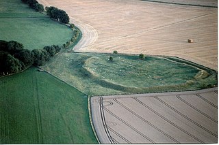
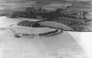
Alfred's Castle is a small Iron Age hill fort, situated at grid reference SU277822, behind Ashdown Park in the civil parish of Ashbury in Oxfordshire. It lies 2–3 km south of the Ridgeway and is protected as a Scheduled Ancient Monument.
Long Wittenham is a village and small civil parish about 3 miles (5 km) north of Didcot, and 3.5 miles (5.6 km) southeast of Abingdon. It was part of Berkshire until the 1974 boundary changes transferred it from Berkshire to Oxfordshire, and from the former Wallingford Rural District to the new district of South Oxfordshire.

Watchfield is a village and civil parish in the Vale of White Horse in on the edge of southwest Oxfordshire, southern England, about 3 miles (4.8 km) southeast of Highworth in neighbouring Wiltshire. Watchfield is about 1 mile (1.6 km) north of the village of Shrivenham. Both villages used to be on the main road between Oxford and Swindon, which is now the A420 road. The Vale of White Horse was part of Berkshire until the 1974 boundary changes administratively transferred it to Oxfordshire.

Moulsford is a village and civil parish in South Oxfordshire. Before 1974 it was in the county of Berkshire, in Wallingford Rural District, but following the Berkshire boundary changes of that year it became a part of Oxfordshire. Moulsford is on the A329, by the River Thames, just north of Streatley and south of Wallingford. The west of the parish is taken up by the foothills of the Berkshire Downs, including the Moulsford Downs. Moulsford Bottom and Kingstanding Hill are traditionally associated with King Alfred and the Battle of Ashdown.
Ruscombe is a village and civil parish, east of Twyford in the Borough of Wokingham in Berkshire, England.

In medieval and Early Modern England, Wales and Ireland, a deer park was an enclosed area containing deer. It was bounded by a ditch and bank with a wooden park pale on top of the bank, or by a stone or brick wall. The ditch was on the inside increasing the effective height. Some parks had deer "leaps", where there was an external ramp and the inner ditch was constructed on a grander scale, thus allowing deer to enter the park but preventing them from leaving.

Garford is a village and civil parish about 4 miles (6.4 km) west of Abingdon. It was part of Berkshire until the 1974 boundary changes transferred it to Oxfordshire. The parish is bounded by the River Ock to the north, by two tributaries of the Ock to the south, and by field boundaries and the road between Kingston Bagpuize and West Hanney to the west. The 2011 Census recorded the parish's population as 229.

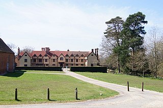
Benham Park is a mansion in the English ceremonial county of Berkshire and district of West Berkshire. It is 2 miles (3.2 km) west of Newbury within 500m of a junction of the A34 trunk road Newbury by-pass outside the town side, in the Marsh Benham locality of Speen, a village within and outside the Newbury by-pass. The house is a Grade II* listed building and park is Grade II.

Cothelstone Manor in Cothelstone, Somerset, England was built in the mid-16th century, largely demolished by the parliamentary troops in 1646 and rebuilt by E.J. Esdaile in 1855–56.

Coleshill House was a country house in England, near the village of Coleshill, in the Vale of White Horse. Historically, the house was in Berkshire but since boundary changes in 1974 its site is in Oxfordshire.

Adelaide Cottage is a house in Windsor Home Park just east of Windsor Castle, in Berkshire. Built in 1831 for Queen Adelaide, it is currently the principal residence of the Prince and Princess of Wales.
Oakley Wood is a 47 hectare woodland with public access situated south of Leamington Spa in Warwickshire, close to the village of Bishop's Tachbrook. The wood is a Plantation on Ancient Woodland Site (PAWS); that is, a site which has been continuously wooded since at least 1600, but which has more recently had much of the native broad-leaved trees felled and replaced with a commercial conifer crop. Records of the wood date back to 12th century, and it contains a scheduled ancient monument known as Oakley Wood Camp.


