Firth is a word in the Scots and English languages used to denote various coastal waters in Scotland and even a strait. In the Northern Isles, it more usually refers to a smaller inlet. It is linguistically cognate to fjord which has a more constrained sense in English. Bodies of water named "firths" tend to be more common on the east coast, or in the southwest of the country, although the Firth of Lorn is an exception to this. The Highland coast contains numerous estuaries, straits, and inlets of a similar kind, but not called "firth" ; instead, these are often called sea lochs. Before about 1850, the spelling "Frith" was more common.

Argyll and Bute is one of 32 unitary authority council areas in Scotland and a lieutenancy area. The current Lord-Lieutenant for Argyll and Bute is Mrs Jane Margaret MacLeod. The administrative centre for the council area is in Lochgilphead at Kilmory Castle, a 19th-century Gothic Revival building and estate. The current Council leader is Aileen Morton.

The Slate Islands are an island group in the Inner Hebrides, lying immediately off the west coast of Scotland, north of Jura and southwest of Oban. The main islands are Seil, Easdale, Luing, Shuna, Torsa and Belnahua. Scarba and Kerrera, which lie nearby, are not usually included.

Seil is one of the Slate Islands, located on the east side of the Firth of Lorn, 7 miles southwest of Oban, in Scotland. Seil has been linked to the mainland by bridge since the late 18th century.
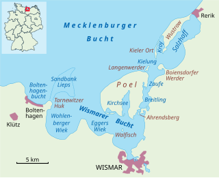
The Bay of Wismar or more commonly Wismar Bay or Wismarbucht is a well sheltered multi-sectioned bay in the southwestern Baltic Sea, in Mecklenburg-Vorpommern, Germany, and is considered the south-central part of the much larger arm of the Baltic known as the Mecklenburg Bay —a long fingerlike gulf oriented to the west-southwest (WSW) from the (central) Baltic proper. Wismar bay is considered one of the finest natural harbors on the Baltic, and served as the destination for much seaborne shipping until circa the 1910s when its minimum depths of 5 meters (16 ft) became too shallow for larger more modern ships. Today, because of the shallow sheltered waters the bay is the subject of much research via underwater archeology

Craobh Haven is a small purpose-built village and sailing port on the west coast of Argyll and Bute, Scotland. It is situated on the Craignish peninsula, 1 mile (1.6 km) to the west of the A816 road, approximately 22 miles (35 km) south of Oban. Craobh Haven is between Arduaine and Kilmartin, and around 17 miles (27 km) north of Lochgilphead.

Bideford Bay, also known as Barnstaple Bay and often shown on maps as Barnstaple or Bideford Bay, is a large area of water on the northwest coast of Devon in South West England, at the southwestern end of the Bristol Channel where it joins the Celtic Sea. The bay extends from Hartland Point in the southwest to Baggy point the northeast, and is partly sheltered by the island of Lundy, 12 miles (19 km) offshore. It takes its alternative names from the towns of Bideford and Barnstaple, located respectively on the rivers Torridge and Taw which flow into the bay. The alternative spelling Barnstable Bay, in use long after that spelling became obsolete for the town, is also sometimes seen.

Gruinard Bay is a large remote coastal embayment, located 12 miles north of Poolewe, in northwestern Ross and Cromarty, and is in the former parish of Lochbroom, in the west coast of Scotland.

Kentra Bay, also known as the Singing Sands, is a remote tidal, 306° orientated, coastal embayment located on the northern shore of the Ardnamurchan peninsula, at the extreme eastern side, where it meets the mainland proper, near Acharacle, in the western Highlands of Scotland. Kentra Bay contains a large expanse of mudflat at low tide and small fragments of salt marsh, sand dune, and machair. Kentra Bay is an inland bay separated from the sea via a channel at the northeast side.

Kelsey Head is a coastal Site of Special Scientific Interest (SSSI) and headland in north Cornwall, England, UK, noted for its biological interest. The site contains an Iron Age hill fort.
Rivoli Bay, is a bay located on the south-east coast of the Australian state of South Australia about 311 kilometres south-southeast of the state capital of Adelaide and about 65 kilometres northwest by west of the regional centre of Mount Gambier. It was named in 1802 by the Baudin expedition of 1800-03 after André Masséna, the Duke of Rivoli and Marshal of France. It is one of four 'historic bays' located on the South Australian coast.

Hardwicke Bay is a bay in the Australian state of South Australia located on the west coast of Yorke Peninsula in Spencer Gulf.

Enard Bay is a large remote tidal coastal embayment, located 10.5 miles northwest of Ullapool, in northwestern Ross and Cromarty, Scottish Highlands in the west coast of Scotland. The mouth of the bay is about 4.5 miles across running from the head of Rubha Mòr peninsula at Rubna Na CòiGeach point to Rubna Na Brèige to the east.

Kames Bay is small remote tidal north by northwest facing coastal embayment forming part of the southern coast of Loch Melfort within Argyll and Bute, Scotland.

Machrihanish Bay is a large remote tidal north by northeast coastal facing embayment, located next to the Campbeltown Airport within Argyll and Bute, Scotland. It is located on the west coast of the Kintyre peninsula. Machrihanish Bay has the longest continuous stretch of sand in Argyll.

Cuil Bay, meaning recess, corner, niche or nook, is a 237° facing, large sand and shingle coastal embayment with a semi-circular outline, on a chord of 2 km, situated on the south‐west part of the Ardsheal peninsula, on the southern coast of the sea loch of Loch Linnhe, in the parish of Lismore and Appin, within the council area of Lochaber in Scotland. It was formerly part of Argyll and Bute before boundary changes occurred. The bay is situated adjacent to the village of Duror. The bay is reached by a small road that leads from the Duror Primary School, leaving the main A828 road, following the line of the River Duror, as it races to meet the sea, before opening out into a vista of a long shore of meadows and sea-grasses as the land meets the bay proper.
Glenborrodale Bay is a remote tidal, 200° orientated, coastal embayment, located on the southern coastline of the west to east orientated Ardnamurchan peninsula, at the head of the sea loch Loch Sunart in western Scottish Highlands of Scotland. To the west is the large Ardgour peninsula, of which the Ardnamurchan and the larger Morven peninsula to the south is part of.
Balmacara Bay is a remote wide mouthed embayment on a 193° orientation, located on the north shore of the Lochalsh peninsula, on the north coast of sea loch of Loch Alsh and is situated next to the scattered village of Balmacara in the Scottish Highlands in the west coast of Scotland.

Erbusaig Bay is a remote coastal embayment, on a 266° orientation, located on the west coast of the Lochalsh peninsula, in the Scottish Highlands in the west coast of Scotland. At the western side of Erbusaig Bay is the small township of Erbusaig.

Loch Kirkaig is a small tidal sea loch, located in the region and parish of Assynt in south-west of Sutherland, in the west coast of Scotland and in the Scottish Highlands. Loch Kirkaig is 1.25 miles south of Loch Inver. The scattered crofting township of Inverkirkaig is located at the headland of the bay, next to the pebbly beach, on the round bay, which has no known name. The name Kirgaig comes from old Norse, Kirkju-vik meaning church bay, perhaps suggesting that in Viking times, there was a church, with a village located in the bay.

