Atakora Department

Last updated
Atakora
Atakora Benin Batia.jpg
Benin - Atakora.svg
Map highlighting the Atakora Department
Coordinates: 10°18′N1°23′E / 10.300°N 1.383°E / 10.300; 1.383
Country Flag of Benin.svg  Benin
Capital Natitingou
Area
[1]
  Total20,499 km2 (7,915 sq mi)
Population
 (2013 census)
  Total769,337
  Density38/km2 (97/sq mi)
Time zone UTC+1 (WAT)

Atakora (also spelled Atacora, named for the Atakora Mountains) is the northwesternmost department of Benin. Externally it borders Togo to the west and Burkina Faso to the north; internally it borders the departments of Alibori, Borgou and Donga. Major towns in the Atakora include Natitingou and Tanguiéta, and the major tourist areas include the Tata Somba houses, Pendjari National Park, and various waterfalls. The department of Atakora was bifurcated in 1999, with its southern territory removed to form the newly created Donga Department. The capital of Atakora Department is Natitingou, which lies among the Atakora Mountains.

Contents

As of 2013, the total population of the department was 772,262, with 380,448 males and 391,814 females. The proportion of women was 50.70%. The total rural population was 62.80%, while the urban population was 37.20%. The total labour force in the department was 170,333, of which 27.20% were women. The proportion of households with no level of education was 72.80%.

Geography

Unpaved road in Atakora, near the border with Togo Benin Atakora dirt road.JPG
Unpaved road in Atakora, near the border with Togo

Atakora Department is located in the northwest of Benin, bordering Burkina Faso to the north, Alibori Department and Borgou Department to the east, Donga Department to the south and Togo to the west. The terrain is mainly forested mountains, from which two tributaries of the Niger River - the Mékrou River and the Pendjari River - originate. [2] Part of the Atakora Mountain Range is located in the region and continues into northeastern Togo. [3] The mountain range is characterised by numerous dambo areas (shallow wetlands) and head swamps. [4] The bulk of the Pendjari National Park lies within Atakora.

The northern regions of Benin receive one season of rainfall from May to September, compared to the southern regions which receive two spells of rain from March to July and September to November. Harmattan winds blow from the northeast during the months of December to March. The country receives an average annual rainfall of around 1,200 mm (47 in). [5]

Settlements

Natitingou is the departmental capital; other major settlements include Boukoumbé, Birni, Firou, Kouandé, Péhunco, Porga, Tanguiéta and Toucountouna.

Demographics

Religious census [6]
ReligionPercent(%)
Muslim
26.9%
Methodist
1.8%
Vodoun
6.3%
Catholic
20.7%
Celestial
0.8%
Other Christian
1.6%
Other Traditional
18%
Other
1.2%
Other Protestant
2.4%

According to Benin's 2013 census, the total population of the department was 772,262, with 380,448 males and 391,814 females. The proportion of women was 50.70%. The total rural population was 62.80%, while the urban population was 37.20%. The proportion of women of childbearing age (15 to 49 years old) was 21.80%. The foreign population was 10,395, representing 1.30% of the total population in the department. The labour force participation rate among foreigners aged 15–64 years was 32.20%. The proportion of women among the foreign population constituted 47.90%. The number of households in the department was 107,599 and the average household size was 7.2. The intercensal growth rate of the population was 3.10%. [7]

Among women, the average age at first marriage was 19.1 and the average age at maternity was 27.8. The synthetic index of fertility of women was 5.6. The average number of families in a house was 1.6 and the average number of persons per room was 1.7. The total labour force in the department was 170,333, of which 27.20% were women. The proportion of households with no level of education was 72.80% and the proportion of households with children attending school was 42.70%. The crude birth rate was 39.0, the general rate of fertility was 179.20 and the gross reproduction rate was 2.80. [6]

The main ethnolinguistic groups in the Department are the Tammari (also known as the Betammaribe, or Somba), Waama and Dendi people. Other groups include the Bariba, Biali, Chakosi (also known as Anufo), Gurma, Lama, Mbelime, Nateni, Ngangam, Notre, Miyobe and Yom. [8]

Administrative divisions

Communes of Atakora Atakora communes.png
Communes of Atakora

The department of Atakora was bifurcated in 1999, when its southern territory was transferred to the newly created Donga Department. The capital of the department is Natitingou. [9] Atakora is subdivided into nine communes, each centred at one of the principal towns: Boukoumbé, Cobly, Kérou, Kouandé, Matéri, Natitingou, Pehonko, Tanguiéta and Toucountouna. [9]

Benin originally had six administrative regions (départements), which have now been bifurcated to make 12. Each of the deconcentrated administrative services (directions départementales) of the sectoral ministries takes care of two administrative regions. A law passed in 1999 transformed the sous-prefectures, the lowest level of territorial administration, into local governments. [9] Municipalities and communal councils have elected representatives who manage the administration of the regions. The latest elections of the municipal and communal councils were held in June 2015. [10]

Related Research Articles

<span class="mw-page-title-main">Demographics of Benin</span>

The demographics of Benin include population density, ethnicity, education level, health of the populace, economic status, religious affiliations and other aspects of the population.

<span class="mw-page-title-main">Alibori Department</span> Department of Benin

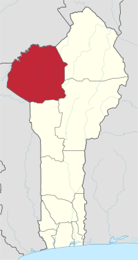
Alibori is the largest and northernmost department of Benin. Externally the department borders the countries of Burkina Faso, Niger, and Nigeria, and internally the departments of Atakora and Borgou. The department of Alibori was created in 1999 when it was split off from Borgou Department and is named after the Alibori River.

<span class="mw-page-title-main">Natitingou</span> Commune and city in Atakora Department, Benin

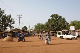
Natitingou, informally referred to as Nati, is a city and commune in north western Benin and the capital of Atakora Department. The commune covers an area of 3045 square kilometres and as of 2013 had a population of 104,010 people.

<span class="mw-page-title-main">Boukoumbé</span> Place in Atakora Department, Benin

Boukoumbé or Boukombé is a town, arrondissement and commune in north western Benin on the border with Togo. It is known for its market, its whipping ceremony and for its tradition of pipe making. Mount Kousso-Kovangou, the highest point in Benin, lies nearby.

<span class="mw-page-title-main">Collines Department</span> Department of Benin

Collines is one of the twelve departments of Benin, located in the centre of the country. The department of Collines was created in 1999 when it was split off from Zou Department. In 2016, the city of Dassa-Zoumé became the department's capital.

<span class="mw-page-title-main">Littoral (Benin)</span> Department of Benin

Littoral is one of the twelve departments of Benin. At 79 km2 (31 sq mi), Littoral is the smallest department in the country. Its capital is Cotonou, Benin's largest city. The department was created in 1999 with the splitting up of territories of Atlantique Department.

<span class="mw-page-title-main">Ouémé Department</span> Department of Benin

Ouémé[we.me] is one of the twelve departments of Benin, containing the capital of the country Porto Novo, named for the Ouémé River. It is subdivided into nine communes, each centred at one of the principal towns: Adjarra, Adjohoun, Aguégués, Akpro-Missérété, Avrankou, Bonou, Dangbo, Porto-Novo and Sèmè-Kpodji. In 1999, the northern section of Ouémé was split off to form the department of Plateau.

<span class="mw-page-title-main">Zou Department</span> Department of Benin

Zou[zu] is one of the twelve departments of Benin, named for the Zou River which travels through the department before emptying into the Atlantic in the south of the country. The department of Zou was split in two in 1999, with the northern territory transferred to the newly created Collines Department. The capital of Zou is Abomey. Zou is subdivided into nine communes, each centred at one of the principal towns: Abomey, Agbangnizoun, Bohicon, Cové, Djidja, Ouinhi, Za-Kpota, Zangnanado and Zogbodomey.

<span class="mw-page-title-main">Plateau Department</span> Department of Benin

Plateau[pla.to] is one of the twelve departments of Benin. The department of Plateau was created in 1999 with an area of 2,835 square kilometres (1,095 sq mi) when it was split off from Ouémé Department. Plateau is subdivided into five communes, each centred at one of the principal towns: Adja-Ouèrè, Ifangni, Kétou, Pobè and Sakété.

<span class="mw-page-title-main">Mono Department</span> Department of Benin

Mono is one of the twelve departments of Benin, with its capital at Lokossa. It is named for the Mono River which forms much of the border with Togo. The northern areas of the department were split off to create the newly formed Kouffo Department in 1999. Mono is subdivided into six communes, each centred at one of the principal towns, namely, Athiémè, Bopa, Comè, Grand-Popo, Houéyogbé and Lokossa. It has an area of 1,396 square kilometres (539 sq mi).

<span class="mw-page-title-main">Donga Department</span> Department of Benin

Donga is one of the twelve departments of Benin; its capital is Djougou, the fourth largest city in the country. The department of Donga was created in 1999 when it was split off from Atakora Department. Donga is subdivided into five communes, each centered at one of the principal towns: Bassila, Copargo, Djougou Rural, Djougou Urban and Ouaké.

<span class="mw-page-title-main">Atlantique Department</span> Regional department in the country of Benin

Atlantique is one of the twelve departments in Benin. The department is located in south-central Benin along the Atlantic coast, between Mono and Kouffo Department in the west, Zou in the north, and Ouémé in the east. The department of Atlantique was bifurcated in 1999 when some of its territories was transferred to the newly formed Littoral Department.

<span class="mw-page-title-main">Kouffo Department</span> Department of Benin

Kouffo or Couffo is one of the twelve departments of Benin. Kouffo borders the country of Togo and the departments of Mono, Zou and Atlantique. Since 2008, the department's capital has been Aplahoué. The department of Kouffo was created in 1999 when it was split off from Mono Department.

<span class="mw-page-title-main">Borgou Department</span> Department of Benin

Borgou[bɔʁ.ɡu] is one of the twelve departments of Benin. Borgou borders the country of Nigeria and the departments of Alibori, Atakora, Collines and Donga. The capital of Borgou is Parakou. The department of Borgou was bifurcated in 1999, with its northern territory transferred to the newly created Alibori Department.

<span class="mw-page-title-main">Tanguiéta</span> Place in Atakora Department, Benin

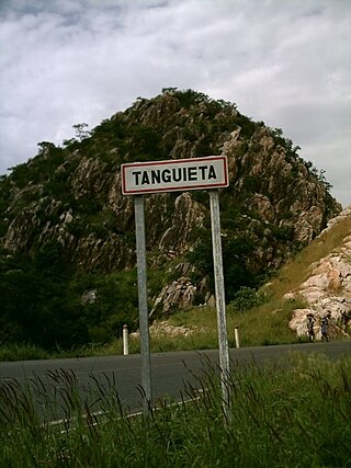
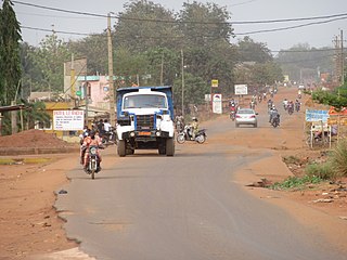
Tanguiéta is a town, arrondissement and commune located in the Atakora Department of Benin.The commune covers an area of 5465 square kilometres and as of 2013 had a population of 74,675 people. As of 2007 the town had an estimated population of 21,290. It lies on the RNIE 3 highway which connects it to Natitingou.

<span class="mw-page-title-main">Religion in Benin</span> Religion in the country

Christianity is the largest religion in Benin, with substantial populations of Muslims and adherents of traditional faiths. According to the most recent 2020 estimate, the population of Benin is 52.2% Christian, 24.6% Muslim, 17.9 Animist and 5.3% follows other faiths or has no religion.

<span class="mw-page-title-main">Agriculture in Benin</span>

Benin is predominantly a rural society, and agriculture in Benin supports more than 70% of the population. Agriculture contributes around 35% of the country's gross domestic product (GDP) and 80% of export income. While the Government of Benin (GOB) aims to diversify its agricultural production, Benin remains underdeveloped, and its economy is underpinned by subsistence agriculture. Approximately 93% of total agricultural production goes into food production. The proportion of the population living in poverty is about 35.2%, with more rural households in poverty (38.4%) than urban households (29.8%). 36% of households depend solely upon agricultural (crop) production for income, and another 30% depend on crop production, livestock, or fishing for income.

<span class="mw-page-title-main">Education in Benin</span> Overview of education in Benin

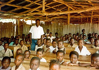
Benin has abolished school fees and is carrying out the recommendations of its 2007 Educational Forum. In 2018, the net primary enrollment rate was 97 percent. Gross enrollment rate in secondary education has greatly increased in the last two decades, from 21.8 percent in 2000 to 59 percent in 2016, 67.1 percent in the case of males and 50.7 percent for females. Because of a rapid increase in the enrollment rate, the student/teacher ratio rose from 36:1 in 1990 to 53:1 in 1997 but has dropped again in the last years to 39:1 (2018). In 2018, the gross enrollment ratio in tertiary education was 12.5%.

<span class="mw-page-title-main">Cobly</span> Place in Atakora Department, Benin

Cobly or Kobli is a town, arrondissement and commune in the Atakora Department of north-western Benin.

Bariba, also known as Baatonum, is the language of the Bariba people of Benin and Nigeria and was the language of the state of Borgu.

References

  1. "Benin". Geohive. Archived from the original on 2017-02-01. Retrieved 25 November 2016.
  2. McColl, R. W. (2014). Encyclopedia of World Geography, Volume 1. Infobase Publishing. pp. 92–93. ISBN   9780816072293.
  3. Idrissa, Abdourahmane; Decalo, Samuel (2012). Historical Dictionary of Niger. Scarecrow Press. p. 77. ISBN   9780810860940.
  4. Hughes, R. H. (1992). A Directory of African Wetlands. IUCN. ISBN   9782880329495.
  5. Haggett, Peter, ed. (2002). Encyclopedia of World Geography, Volume 17. Marshall Cavendish. p. 2325. ISBN   9780761473060.
  6. 1 2 "Socio economic data of Benin, 2013". Institut National de la Statistique et de l’Analyse Economique (INSAE) du Benin. 2013. Retrieved 25 November 2016.
  7. "Census of Benin, 2013". Institut National de la Statistique et de l’Analyse Economique (INSAE) du Benin. 2013. Retrieved 25 November 2016.
  8. "Languages of Benin". Ethnologue . Retrieved 26 November 2019.
  9. 1 2 3 Republic of Benin, Public Administration and Country profile (PDF) (Report). Department of Economic and Social Affairs (DESA), United Nations. 2004. p. 8. Archived from the original (PDF) on 22 December 2018. Retrieved 17 November 2016.
  10. "Local elections in Benin, 2015". African Elections Database. Retrieved 25 November 2016.