Athol, Idaho

Last updated

Athol, Idaho
Kootenai County Idaho Incorporated and Unincorporated areas Athol Highlighted 1603700.svg
Location of Athol in Kootenai County, Idaho.
Usa edcp location map.svg
Red pog.svg
Athol, Idaho
Location in the United States
Coordinates: 47°56′46″N116°42′26″W / 47.94611°N 116.70722°W / 47.94611; -116.70722
Country United States
State Idaho
County Kootenai
Incorporated1909
Area
[1]
  Total0.89 sq mi (2.30 km2)
  Land0.89 sq mi (2.30 km2)
  Water0.00 sq mi (0.00 km2)
Elevation
2,392 ft (729 m)
Population
 (2020) [2]
  Total709
  Density796.63/sq mi (307.58/km2)
Time zone UTC-8 (Pacific (PST))
  Summer (DST) UTC-7 (PDT)
ZIP code
83801
Area code 208
FIPS code 16-03700
GNIS feature ID0376763
Website cityofathol.us

Athol AH-thol; is a city in Kootenai County, Idaho, United States. The population was 709 at the 2020 census, up from 692 in the 2010 census. [3] It is part of the Coeur d'Alene Metropolitan Statistical Area, which includes the entire county. Its main attraction is Silverwood Theme Park.

Contents

Description

Athol contains the Silverwood Theme Park. Several miles east of the city is the historic Farragut State Park, located at the southern end of Lake Pend Oreille. In March 2022, Dollar General opened its first storefront in the state of Idaho in Athol. [4]

History

A post office called the Athol Post Office has been in operation since 1895. [5] The city may be named after the Duke of Atholl. [6]

The City of Athol website details a brief history as follows:

Until the early 1800s when explorers/trappers began coming into the area, American Indian-primarily of the Coeur d’ Alene and Spokane Tribes- had exclusive use of the land as they migrated through the region en route to their encampments near the area’s many lakes and streams.

All this changed when the Northern Pacific Railroad station was built in Athol in 1882, and settlers hoped for a vast agricultural paradise. The depot was established in Athol on its line between Hauser Junction and Sandpoint. In 1895 town residents, mostly railroad employees and then homesteaders, successfully petitioned postal authorities for a post office. The white pine forest first attracted early settlers to Athol, and logging, milling, and agriculture created prosperity. However, the location of the new community was on state lands. In 1903, lots in Athol were auctioned by the state. State surveyors platted the new township but, apparently, did not record the change in ownership. For many years, the town’s residents did not have title to their land. Eventually the state corrected the problem.

Athol was first known as Colton, the town was renamed Athol by a settler who came from Athol, Massachusetts. The Massachusetts Athol was named after a town in Scotland named for the Duke of Atholl. No one knows for sure if Athol, Idaho was named by a descendent of the same family or if the name was just brought west during the 19th Century.

In 1900 the Methodist congregation built a church that also served as a school until 1902 when school patrons built their first school building. In December 1902 Hackett & Wilson opened a sawmill near the city. The mill became the city’s largest employer and had the capacity of producing 25,000 board feet of lumber per day. By 1903 there were many businesses opened, including the Pacific Hotel, a drugstore, a smithy, a jewelry store, restaurants, a mercantile company, and a saloon.

Athol’s first water well was dug by hand by Joe Pricsha and his crew. It was 350 plus feet deep. They dug into a large boulder, so they had to dig around it, which made a curve in the shaft. A 5hp pump motor was installed, which supplied the town with water. Later, another shaft with a larger pump was installed in the same hand-dug hole.

Geography

Athol is located at 47°56′46″N116°42′26″W / 47.94611°N 116.70722°W / 47.94611; -116.70722 (47.946024, -116.707349), [7] at an elevation of 2,392 feet (729 m) above sea level.

According to the United States Census Bureau, the city has a total area of 0.79 square miles (2.05 km2), all of it being land. [8]

Demographics

Historical population
CensusPop.Note
1910 281
1920 180−35.9%
1930 116−35.6%
1940 1203.4%
1950 22688.3%
1960 214−5.3%
1970 190−11.2%
1980 31264.2%
1990 34610.9%
2000 67695.4%
2010 6922.4%
2020 7092.5%
U.S. Decennial Census [9]

As of 2000 the median income for a household in the city was $30,595, and the median income for a family was $31,875. Males had a median income of $28,438 versus $17,813 for females. The per capita income for the city was $13,632. About 11.0% of families and 14.5% of the population were below the poverty line, including 10.3% of those under age 18 and 23.7% of those age 65 or over.

2010 census

As of the census [2] of 2010, there were 692 people, 282 households, and 176 families residing in the city. The population density was 875.9 inhabitants per square mile (338.2/km2). There were 305 housing units at an average density of 386.1 per square mile (149.1/km2). The racial makeup of the city was 97.0% White, 0.9% Native American, and 2.2% from two or more races. Hispanic or Latino of any race were 0.3% of the population.

There were 282 households, of which 29.4% had children under the age of 18 living with them, 47.9% were married couples living together, 8.9% had a female householder with no husband present, 5.7% had a male householder with no wife present, and 37.6% were non-families. 28.0% of all households were made up of individuals, and 10.3% had someone living alone who was 65 years of age or older. The average household size was 2.45 and the average family size was 3.05.

The median age in the city was 41.8 years. 23.7% of residents were under the age of 18; 6.7% were between the ages of 18 and 24; 23.2% were from 25 to 44; 30.8% were from 45 to 64; and 15.6% were 65 years of age or older. The gender makeup of the city was 52.2% male and 47.8% female.

Notable person

See also

Related Research Articles

<span class="mw-page-title-main">Kootenai County, Idaho</span> County in Idaho, United States

Kootenai County is located in the U.S. state of Idaho. As of the 2020 census, its population was 171,362, making it the third-most populous county in Idaho and by far the largest in North Idaho, the county accounting for 45.4% of the region's total population. The county seat and largest city is Coeur d'Alene. The county was established in 1864 and named after the Kootenai tribe.

<span class="mw-page-title-main">Boundary County, Idaho</span> County in Idaho, United States

Boundary County is the northernmost county of the U.S. state of Idaho. As of the 2020 census, the population was 12,056. The county seat and largest city is Bonners Ferry.

<span class="mw-page-title-main">Bonner County, Idaho</span> County in Idaho, United States

Bonner County is a county in the northern part of the U.S. state of Idaho. As of the 2020 census, the population was 47,110. The county seat and largest city is Sandpoint. Partitioned from Kootenai County and established in 1907, it was named for Edwin L. Bonner, a ferry operator.

<span class="mw-page-title-main">Post Falls, Idaho</span> City in Idaho, United States

Post Falls is a city in Kootenai County, Idaho, United States. It is the gateway city to North Idaho on I-90 just west of Coeur d'Alene and east of Spokane, Washington. The population was 38,485 at the 2020 census, making it Idaho's ninth-largest city and the second largest city in North Idaho behind Coeur d’Alene.

<span class="mw-page-title-main">Clark Fork, Idaho</span> City in Idaho, United States

Clark Fork is a small town in Bonner County, Idaho. The population was 536 at the time of the 2010 census.

<span class="mw-page-title-main">Hope, Idaho</span> City in Idaho, United States

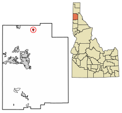
Hope is a city in Bonner County, Idaho, United States. The population was 86 at the 2010 census.

<span class="mw-page-title-main">Kootenai, Idaho</span> City in Idaho, United States

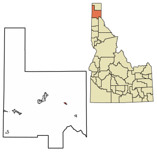
Kootenai is a city in Bonner County, Idaho. The population was 678 at the 2010 census.

<span class="mw-page-title-main">Ponderay, Idaho</span> City in Idaho, United States

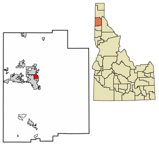
Ponderay is a city in Bonner County, Idaho. The population was 1,137 at the 2010 census, up from 638 in 2000. Ponderay's city motto is "Little City with the Big Future". Its name is an English phonetic spelling of the French words “Pend Oreille”, the name of the lake the city sits upon.

<span class="mw-page-title-main">Bonners Ferry, Idaho</span> City in Idaho

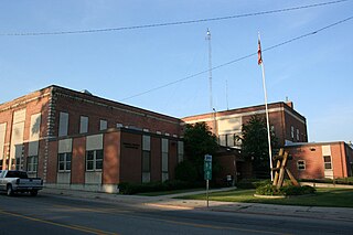
Bonners Ferry is the largest of two cities in and the county seat of Boundary County, Idaho, United States. The population was 2,543 at the 2010 census.

<span class="mw-page-title-main">Dalton Gardens, Idaho</span> City in Kootenai County, Idaho, United States

Dalton Gardens is a city in Kootenai County, Idaho, United States. It is considered a suburb of Coeur d'Alene and borders the city to the north and east. The city of Dalton Gardens is also part of the larger Spokane-Coeur d'Alene Combined Metropolitan Statistical Area which encompasses Kootenai County, Idaho. The population of Dalton Gardens was 2,335 at the time of the 2010 census.

<span class="mw-page-title-main">Fernan Lake Village, Idaho</span> City in Idaho, United States

Fernan Lake Village is a city in Kootenai County, Idaho, United States. The population was 169 at the 2010 census.

<span class="mw-page-title-main">Harrison, Idaho</span> City in Idaho, United States

Harrison is a city in Kootenai County, Idaho, United States. The population was 203 at the 2010 census. Harrison is located on the eastern shore of Lake Coeur d'Alene, immediately south of where the Coeur d'Alene River flows into the lake.

<span class="mw-page-title-main">Hayden, Idaho</span> City in Idaho, United States

Hayden is a city in Kootenai County, Idaho, United States. Located in the northern portion of the state, it is a suburb of nearby Coeur d'Alene and its population was 15,570 at the 2020 census.

<span class="mw-page-title-main">Hayden Lake, Idaho</span> City in Idaho, United States

Hayden Lake is a city in Kootenai County, Idaho, United States. Located in the northern portion of the state, it is considered a suburb of the city of Coeur d'Alene. Its population was 574 at the 2010 census. The city was named after the nearby Lake Hayden, which is now more commonly also known as Hayden Lake, after the city.

<span class="mw-page-title-main">Huetter, Idaho</span> City in Idaho, United States

Huetter is a city in Kootenai County, Idaho, United States. The population was 100 at the 2010 census.

<span class="mw-page-title-main">Spirit Lake, Idaho</span> City in Idaho, United States

Spirit Lake is a city in Kootenai County, Idaho. The population was 1,945 at the time of the 2010 census, up from 1,376 in 2000. It is part of the Coeur d'Alene Metropolitan Statistical Area, which includes the entire county.

<span class="mw-page-title-main">Stateline, Idaho</span> City in Idaho, United States

Stateline, officially the City of State Line, and historically known as State Line Village, is a city in Kootenai County, Idaho, United States, and is both the easternmost suburb of Spokane, Washington and the westernmost suburb of Coeur d'Alene, Idaho. The population was 39 at the 2020 census. The city is known for the adult services it provides which attract business from nearby Spokane and Coeur d'Alene. The unincorporated community of Spokane Bridge, Washington is located across the Spokane River to the southwest.

<span class="mw-page-title-main">Worley, Idaho</span> City in Idaho, United States

Worley is a city in southwestern Kootenai County, Idaho, United States. The population was 257 at the 2010 census, up from 223 in 2000. The city is within the Coeur d'Alene Indian Reservation.

<span class="mw-page-title-main">Smelterville, Idaho</span> City in Idaho, United States

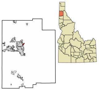
Smelterville is a city in Shoshone County, Idaho, United States. The population was 627 at the 2010 census.

<span class="mw-page-title-main">Wardner, Idaho</span> City in Idaho, United States

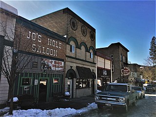
Wardner is a city in Shoshone County, Idaho, United States. Located in the Silver Valley mining region, the population was 188 at the 2010 census, down from 215 in 2000.

References

  1. "2019 U.S. Gazetteer Files". United States Census Bureau. Retrieved July 9, 2020.
  2. 1 2 "U.S. Census website". United States Census Bureau . Retrieved December 18, 2012.
  3. Spokesman-Review Archived 2016-03-04 at the Wayback Machine - 2010 census - Athol, Idaho - accessed 2011-12-26
  4. Wixey, Will (March 6, 2022). "Dollar General opens first Idaho store in Athol". KXLY kxly.com. Retrieved July 2, 2023.
  5. "Kootenai County". Jim Forte Postal History. Archived from the original on May 31, 2015. Retrieved May 30, 2015.
  6. Taggart, Cynthia (September 6, 1985). "What's in a name?". Spokane Chronicle. p. 3. Retrieved May 30, 2015.
  7. "US Gazetteer files: 2010, 2000, and 1990". United States Census Bureau. February 12, 2011. Retrieved April 23, 2011.
  8. "US Gazetteer files 2010". United States Census Bureau. Archived from the original on January 25, 2012. Retrieved December 18, 2012.
  9. "Census of Population and Housing". Census.gov. Retrieved June 4, 2015.