Huetter, Idaho | |
---|---|
City of Huetter | |
Coordinates: 47°42′14″N116°50′56″W / 47.70389°N 116.84889°W Coordinates: 47°42′14″N116°50′56″W / 47.70389°N 116.84889°W | |
Country | United States |
State | Idaho |
County | Kootenai |
Incorporated | 1905 |
Founded by | John Theodore Huetter [1] |
Government | |
• Mayor | Bradley Keene |
Area | |
• Total | 0.04 sq mi (0.12 km2) |
• Land | 0.04 sq mi (0.12 km2) |
• Water | 0.00 sq mi (0.00 km2) |
Elevation | 2,142 ft (653 m) |
Population | |
• Total | 100 |
• Estimate (2019) [4] | 112 |
• Density | 2,488.89/sq mi (953.43/km2) |
Time zone | UTC-8 (Pacific (PST)) |
• Summer (DST) | UTC-7 (PDT) |
Area code | 208 |
FIPS code | 16-39070 |
GNIS feature ID | 0396678 |
Huetter is a city in Kootenai County, Idaho, United States. The population was 100 at the 2010 census. [5]
Huetter is located at 47°42′14″N116°50′56″W / 47.70389°N 116.84889°W (47.703759, -116.848870). [6]
According to the United States Census Bureau, the city has a total area of 0.04 square miles (26 acres; 0.10 km2), all land. This makes Huetter the smallest incorporated city in the United States in terms of area. [7]
Bradley Keene and Jennifer Brown were among a group of young people who attempted a takeover of Huetter by running for mayor and city councilor, respectively, in 2007. Keene was elected, ousting longtime mayor Jackie Meeks, as was Brown; just 32 people voted in the election. [8]
However, a District judge ruled in May 2008 that Keene and Brown were ineligible to serve their term because the county had kicked them off voter registration rolls earlier in the year, a result of them not responding to challenges of their Huetter residency during the election. Keene then appealed the decision. In the ensuing two years Huetter had no official mayor, due to the litigation over the position; however, Keene had been serving as acting mayor since being elected to the city council in 2009.
Finally, in 2010, the Idaho Supreme Court ruled that the District Court had misinterpreted state statute in concluding that Keene's and Brown's positions became vacant when their voter registration was temporarily canceled after their election. The opinion reversed the removal of Keene and Brown (who later moved out of Huetter, and her council position was filled). Keene was re-elected mayor in 2011, running unopposed. [9]
Historical population | |||
---|---|---|---|
Census | Pop. | %± | |
1950 | 84 | — | |
1960 | 114 | 35.7% | |
1970 | 49 | −57.0% | |
1980 | 65 | 32.7% | |
1990 | 82 | 26.2% | |
2000 | 96 | 17.1% | |
2010 | 100 | 4.2% | |
2019 (est.) | 112 | [4] | 12.0% |
U.S. Decennial Census [10] |
As of the census [11] of 2010, there were 100 people, 42 households, and 22 families residing in the city. The population density was 3,333.3 inhabitants per square mile (1,287.0/km2). There were 48 housing units at an average density of 1,600.0 per square mile (617.8/km2). The racial makeup of the city was 88.0% White, 1.0% African American, 3.0% Native American, 1.0% Asian, and 7.0% from two or more races. Hispanic or Latino of any race were 7.0% of the population.
There were 42 households, of which 26.2% had children under the age of 18 living with them, 28.6% were married couples living together, 14.3% had a female householder with no husband present, 9.5% had a male householder with no wife present, and 47.6% were non-families. 38.1% of all households were made up of individuals. The average household size was 2.14 and the average family size was 2.55.
The median age in the city was 39.5 years. 14% of residents were under the age of 18; 8% were between the ages of 18 and 24; 38% were from 25 to 44; 32% were from 45 to 64; and 8% were 65 years of age or older. The gender makeup of the city was 55.0% male and 45.0% female.
As of the census [12] of 2000, there were 96 people, 37 households, and 21 families residing in the city. The population density was 9,044.4 inhabitants per square mile (3,492.1/km2). There were 39 housing units at an average density of 3,674.3 per square mile (1,418.7/km2). The racial makeup of the city was 87.50% White, 2.08% Native American, 3.12% from other races, and 7.29% from two or more races. Hispanic or Latino of any race were 3.12% of the population.
There were 37 households, out of which 29.7% had children under the age of 18 living with them, 35.1% were married couples living together, 8.1% had a female householder with no husband present, and 43.2% were non-families. 27.0% of all households were made up of individuals, and 5.4% had someone living alone who was 65 years of age or older. The average household size was 2.59 and the average family size was 2.62.
In the city, the population was spread out, with 19.8% under the age of 18, 21.9% from 18 to 24, 34.4% from 25 to 44, 17.7% from 45 to 64, and 6.3% who were 65 years of age or older. The median age was 30 years. For every 100 females, there were 134.1 males. For every 100 females age 18 and over, there were 148.4 males.
The median income for a household in the city was $21,250, and the median income for a family was $22,083. Males had a median income of $28,750 versus $51,250 for females. The per capita income for the city was $9,121. There were 23.8% of families and 30.9% of the population living below the poverty line, including 36.8% of under eighteens and none of those over 64.
Star is a city in northwestern Ada County, Idaho, with parts stretching into neighboring Canyon County. The population was 5,793 at the 2010 census, up from 1,795 in 2000. It was named in the 19th century by travelers on their way to Middleton and Boise who used the star on the school house to find east and west. The name stuck and it became Star, Idaho. Today, it is a rapidly growing suburb of Boise and its schools are shared with Middleton School District and West Ada School District.
Council is a city in and the county seat of Adams County, Idaho, United States. The population was 839 at the 2010 census.
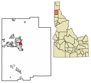
Kootenai is a city in Bonner County, Idaho. The population was 678 at the 2010 census.
Ponderay is a city in Bonner County, Idaho. The population was 1,137 at the 2010 census, up from 638 in 2000. Ponderay's city motto is "Little City with the Big Future". Its name is an English phonetic spelling of the French words “Pend Oreille”, the name of the lake the city sits upon.
Priest River is a city in Bonner County, Idaho. The population was 1,751 at the 2010 census. Located in the Idaho Panhandle region of the state, the city is at the mouth of the Priest River on the Pend Oreille River.
Swan Valley is a city in Bonneville County, Idaho, United States. It is part of the Idaho Falls, Idaho Metropolitan Statistical Area. The population was 204 at the 2010 census.
Moyie Springs is a city in Boundary County, Idaho, United States. The population was 718 at the 2010 census.
Greenleaf is a city in Canyon County, Idaho, United States. The population was 846 at the 2010 census. Greenleaf is part of the Boise-Nampa metropolitan area. The town was established by Quakers in the early-1900s and is named after Quaker poet and abolitionist John Greenleaf Whittier.
Notus is a small rural city in Canyon County, Idaho. The population was 531 at the time of the 2010 census and is the smallest town out of the eight in Canyon County. It is part of the Boise metropolitan area.
Parma is a city in Canyon County, Idaho, United States. The population was 1,983 at the 2010 census, up from 1,771 in 2000. It is the fourth largest city in the county and the largest in the rural western portion. It is part of the Boise City–Nampa, Idaho Metropolitan Statistical Area.
Riggins is a city in the western United States in Idaho County, Idaho. Nestled deep in a canyon at the confluence of the Salmon and Little Salmon rivers in west central Idaho, it is approximately 150 highway miles (240 km) north of Boise, and 120 highway miles (190 km) south-southeast of Lewiston. The elevation is 1,821 feet (555 m) above sea level, and its population was 419 at the 2010 census.
Jerome is a city in and county seat of Jerome County, Idaho, United States. The population was 10,890 at the 2010 census, up from 7,780 in 2000. The city is the county seat of Jerome County, and is part of the Twin Falls Micropolitan Statistical Area. It is the second largest city in Idaho's Magic Valley region, second only to Twin Falls which is located 10 miles (16 km) southeast. Jerome's economy is largely agrarian, with dairy farming being one of the main revenue sources for the local economy.
Dalton Gardens is a city in Kootenai County, Idaho. It is considered a suburb of Coeur d'Alene and borders the city to the north and east. The city of Dalton Gardens is also part of the larger Spokane-Coeur d'Alene Combined Metropolitan Statistical Area which encompasses Kootenai County, Idaho. The population of Dalton Gardens was 2,335 at the time of the 2010 census.
Genesee is a city in Latah County, Idaho, United States. The population was 955 at the 2010 census, up from 946 in 2000. The city was named for the Genesee region of western New York, although it may also be a modification of the biblical Genesis.
Onaway is a city in Latah County, Idaho, United States. The population was 187 at the 2010 census, down from 230 in 2000.
Reubens is a city in Lewis County, Idaho, United States, on the Camas Prairie. The population was 71 at the 2010 census, and 72 in 2000.
Peck is a city in Nez Perce County, Idaho, United States. The population was 197 at the 2010 census. It is part of the Lewiston, ID-WA Metropolitan Statistical Area. Many residents of Peck work in nearby Orofino, Idaho. Additionally, Peck residents attend high school in Orofino since Peck does not have a high school.
Grand View is a city in Owyhee County, Idaho, United States. The population was 452 at the 2010 census. It is part of the Boise City–Nampa, Idaho Metropolitan Statistical Area.
Smelterville is a city in Shoshone County, Idaho, United States. The population was 627 at the 2010 census.
Wardner is a city in Shoshone County, Idaho, United States. Located in the Silver Valley mining region, the population was 188 at the 2010 census, down from 215 in 2000.