
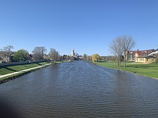
The Au Sable River is a 138-mile-long (222 km) river in the Lower Peninsula of the U.S. state of Michigan. Rising in the Northern Lower Peninsula, the river flows in a generally southeasterly direction to its mouth at Lake Huron at the communities of Au Sable and Oscoda. It is considered one of the best brown trout fisheries east of the Rockies and has been designated a blue ribbon trout stream by the Michigan Department of Natural Resources. A map from 1795 located in the United States Gazetteer calls it the Beauais River. In French, the river is called the Rivière au sable, literally "Sand River".

Iosco County is a county in the U.S. state of Michigan; its eastern border is formed by Lake Huron. As of the 2020 census, its population was 25,237. Its seat of government is Tawas City.

Arenac County is a county located in the U.S. state of Michigan. As of the 2020 Census, the population was 15,002. The county seat is Standish.

Au Gres is a city in Arenac County in the U.S. state of Michigan. The population was 945 at the 2020 census.

Au Gres Township is a civil township of Arenac County in the U.S. state of Michigan. As of the 2020 census, the township population was 896. The city of Au Gres borders the township to the east but both are administered autonomously.

Standish Township is a civil township of Arenac County in the U.S. state of Michigan. The population was 1,701 at the 2020 census. The city of Standish borders the township on the northwest but is administered autonomously.

The Huron–Manistee National Forests are two separate national forests, the Huron National Forest and the Manistee National Forest, combined in 1945 for administration purposes and which comprise 978,906 acres (3,960 km2) of public lands, including 5,786 acres (23 km2) of wetlands, extending across the northern lower peninsula of Michigan. The Huron–Manistee National Forests provide recreation opportunities for visitors, habitat for fish and wildlife, and resources for local industry. The headquarters for the forests is in Cadillac, Michigan.

Northern Michigan, also known as Northern Lower Michigan, is a region of the U.S. state of Michigan. A popular tourist destination, it is home to several small- to medium-sized cities, extensive state and national forests, lakes and rivers, and a large portion of Great Lakes shoreline. The region has a significant seasonal population much like other regions that depend on tourism as their main industry. Northern Lower Michigan is distinct from the more northerly Upper Peninsula and Isle Royale, which are also located in "northern" Michigan. In the northernmost 21 counties in the Lower Peninsula of Michigan, the total population of the region is 506,658 people.
The Cass River is a 61.5-mile-long (99.0 km) river in the Thumb region of the U.S. state of Michigan. It drains large portions of Sanilac and Tuscola counties and smaller portions of Genesee, Huron, Lapeer, and Saginaw counties.
Charity Island, also known as Big Charity Island, is the largest island in Saginaw Bay, in the Michigan waters of Lake Huron. The island is 222 acres (0.90 km2) in area and has about 3 miles (4.8 km) of shoreline. It is part of Whitney Township, in Arenac County. The island also contains an 11-acre (0.04 km2) pond, literally a 'lake within a lake', fed by springs.

M-65 is a 103.176-mile-long (166.046 km) state trunkline highway in the US state of Michigan. The highway runs between termini on US Highway 23 (US 23) near Omer and Rogers City in the northeastern Lower Peninsula of the state. M-65 runs inland through several small communities in the region, passing through forests and fields along its course. M-65 crosses several watercourses, including the Au Sable River where it runs along the River Road National Scenic Byway. The region also includes the Huron National Forest and the Mackinaw State Forest areas.
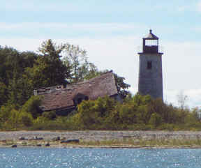
Charity Island Light is a lighthouse on Big Charity Island in Lake Huron just off the coast of Au Gres, Northern Michigan.

The Cheboygan River is a river in the U.S. state of Michigan. The seven-mile (11 km) river flows from Mullett Lake to Lake Huron,with its mouth in the city of Cheboygan. The river forms part of the Inland Waterway, a 38-mile-long (61 km) series of lakes and rivers that nearly connect Little Traverse Bay, a bay of Lake Michigan, with Lake Huron. The Black River is the largest tributary of the Cheboygan River.

Rifle River is a 60.3-mile-long (97.0 km) river in the U.S. state of Michigan. It rises in northeastern Ogemaw County and flows through Arenac County to enter Saginaw Bay of Lake Huron. Once a logging river during the Michigan forestry boom at the turn of the 20th century, the river is now primarily used for recreation, and is a state-designated natural river. It is a popular river for canoeing, with no portages or dams and an average depth of 18 inches, to 5 feet in downtown Omer. It is also known for having one of the best White Sucker runs in the state of Michigan, in the spring.
The Saganing River, also known as Saganing Creek, is a 10.0-mile-long (16.1 km) stream in the U.S. state of Michigan.

The Trout River is an 8.5-mile-long (13.7 km) river in Presque Isle County, Michigan, in the United States. It flows into Lake Huron at Rogers City.
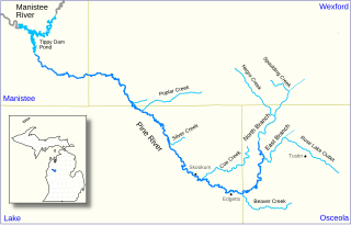
The Pine River, formerly known as the South Branch Manistee River, is a 53.6-mile-long (86.3 km) tributary of the Manistee River in the U.S. state of Michigan. It forms at the confluence of the North Branch and East Branch of the Pine River in northwest Osceola County, flows southwest, then west and north through the northeast corner of Lake County and into southwest Wexford County, emptying into the Tippy Dam Pond on the Manistee River in Manistee County. The Pine River watershed drains an area of 265 square miles (690 km2).

The St. Joseph Channel is a strait in Algoma District, Northwestern Ontario, Canada and Chippewa County, Michigan, United States. It is in the Great Lakes Basin and connects the St. Marys River flowing through the Middle Neebish Channel between Neebish Island and Sugar Island at the northwest and Lake George/ East Neebish Channel between Sugar Island and the Ontario mainland at the north, with the North Channel between St. Joseph Island and the Ontario mainland at the east, and with the Munuscong Channel between Neebish Island and St. Joseph Island at the southwest. All of these waterbody elements are part of Lake Huron.
Lake George is a lake in Chippewa County, Michigan, United States, and Algoma District, Northwestern Ontario, Canada, that lies between Sugar Island in Michigan on the west and the Ontario mainland on the east.
