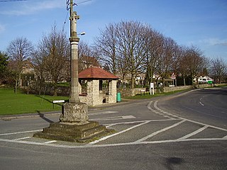
Cranwell is a village in the North Kesteven district of Lincolnshire, England. It is part of the civil parish of Cranwell and Byard's Leap and is situated approximately 3 miles (5 km) north-west from Sleaford and 14 miles (23 km) south-east from Lincoln. The principal through road, the B1429 between the A15 to the east and the A17 to the west, joins the village to RAF Cranwell. The appropriate civil parish is called Cranwell, Brauncewell and Byard's Leap with a population of 2,827 at the 2011 census.

Haddington is a hamlet in the North Kesteven district of Lincolnshire, England. It is situated just off the Fosse Way Roman road, now the A46, 7 miles (11 km) south-west from Lincoln and 1 mile (1.6 km) west from Aubourn. It is in the civil parish of Aubourn with Haddington.

North Kesteven is a local government district in Lincolnshire, England. The council is based in Sleaford. The district also contains the town of North Hykeham, which adjoins the neighbouring city of Lincoln, along with numerous villages and surrounding rural areas.

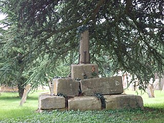
Sempringham is a hamlet in the South Kesteven district of Lincolnshire, England. It is situated 2 miles (3.2 km) south from the A52 road, 12 miles (19 km) east from Grantham and 8 miles (13 km) north from Bourne. The hamlet is in the civil parish of Pointon and Sempringham, and on the western edge of the Lincolnshire Fens, the closest village being Billingborough, 0.5 miles (0.80 km) to the north on the B1177 road. Sempringham is noted as the home of Gilbert of Sempringham, the son of the lord of the manor. Gilbert is the only English Saint to have founded a monastic order, the Gilbertines.

Aslackby and Laughton is a civil parish in the South Kesteven district of Lincolnshire, England. According to the 2001 census the parish had a population of 243, in 102 households. increasing slightly to 251 in 118 households at the 2011 census. It consists of the village of Aslackby, the hamlet of Laughton, and scattered farms, and part of the hamlet of Graby.

Aubourn Haddington and South Hykeham was a former civil parish in the North Kesteven district of Lincolnshire, England. According to the 2001 census it had a population of 885.
North Hykeham is a town and civil parish in the North Kesteven district, in the county of Lincolnshire, England. It forms part of the Lincoln Urban Area. The population of the town at the 2011 census was 13,884.

Bottesford is a town in North Lincolnshire, Lincolnshire, England.

Partney is a small village and civil parish in the East Lindsey district of Lincolnshire, England. It is situated 3 miles (4.8 km) north of Spilsby, and in the Lincolnshire Wolds. The village was the birthplace of Henry Stubbe, the noted 17th-century Intellectual.

Caythorpe is a large village and civil parish in the South Kesteven district of Lincolnshire, England. The population at 2011 census was 1,374. It is situated on the A607, approximately 3 miles (5 km) south from Leadenham and 9 miles (14 km) north from Grantham. Caythorpe Heath stretches east of the village to Ermine Street and Byards Leap.
Edenham is a village and civil parish in the South Kesteven district of Lincolnshire, England. It is approximately 3 miles (5 km) north-west of Bourne, and on the A151 road. While the civil parish is called 'Edenham', the parish council is called Edenham, Grimsthorpe, Elsthorpe & Scottlethorpe Parish Council. The population of the civil parish at the 2011 census was 291.

Honington is an English village and civil parish in the South Kesteven district of Lincolnshire. It lies just north of the junction between the A153 and A607 roads, about 5.5 miles (8.9 km) north of Grantham and 8 miles (12.9 km) west of Sleaford.
Skellingthorpe is a village and civil parish in the North Kesteven district of Lincolnshire, England. The population of the village at the 2011 census was 3,465. It is situated 3 miles (5 km) west of Lincoln, 4 miles (6 km) southeast of Saxilby, 6 miles (10 km) northwest of North Hykeham and 15 miles (24 km) east of Tuxford.

Quarrington is a village and former civil parish, now part of the civil parish of Sleaford, in the North Kesteven district of Lincolnshire, England. The old village and its church lie approximately 1 miles (2 km) south-west from the centre of Sleaford. Suburban housing developments at New Quarrington and Quarrington Hill effectively link the two settlements. Bypassed by the A15, it is connected to Lincoln and Peterborough, as well as Newark and King's Lynn. At the 2011 census, Quarrington and Mareham ward, which incorporates most of the settlement, had an estimated population of 7,046.
South Hykeham is a village and civil parish in the North Kesteven district of Lincolnshire, England. The population of the civil parish at the 2011 census was 835. It is situated approximately 3 miles (5 km) south-west from the city and county town of Lincoln, and on the A1434 road. Since 1931, South Hykeham formed part of the civil parish of Aubourn Haddington and South Hykeham, but this relationship was broken in 1991 and South Hykeham is again a civil parish.

Walcot is a village and civil parish in the North Kesteven district of Lincolnshire, England. It lies 1 mile (1.6 km) west from the A15, 7 miles (11 km) south from Sleaford, 9 miles (14 km) east from Grantham, and 1 mile north from Folkingham. The population is included in the civil parish of Newton and Haceby.
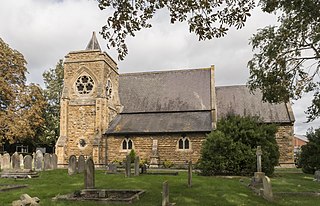
St Peter's Church is a Grade I listed Anglican parish church dedicated to Saint Peter, in Ropsley, Lincolnshire, England. The church is 5 miles (8 km) east from Grantham, and in the South Kesteven Lincolnshire Vales. St Peter's is in the ecclesiastical parish of Ropsley, and is part of the North Beltisloe Group of churches in the Deanery of Beltisloe, and the Diocese of Lincoln.

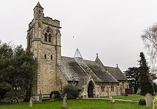
The Church of St John the Evangelist is a Grade I listed Church of England parish church dedicated to John the Evangelist, in Corby Glen, Lincolnshire, England. The church is 9 miles (14 km) south-east of Grantham, and in the South Kesteven Lincolnshire Vales. It is noted in particular for its 14th- and 15th-century medieval wall paintings.

Aubourn with Haddington or Aubourn and Haddington is a civil parish in the North Kesteven district of Lincolnshire, England. The population of the civil parish at the 2011 census was 460.

Central Lincolnshire is the name given to a region of Lincolnshire in the East Midlands, England. The area covers the districts of North Kesteven and West Lindsey as well as the City of Lincoln. The name is used for the planning and development of a part of Lincolnshire surrounding Lincoln, North Hykeham, Sleaford, Market Rasen, Caistor and Gainsborough as well as other outlying villages and hamlets.


