
Nadia is a district in the state of West Bengal, India. It borders Bangladesh to the east, North 24 Parganas and Hooghly districts to the south, Purba Bardhaman to the west, and Murshidabad to the north.

The Khulna District is a district of Bangladesh. It is located in the Khulna Division, bordered on the north by the Jessore District and the Narail District, on the south by the Bay of Bengal, on the east by the Bagerhat District, and on the west by the Satkhira District. It was the very first sub-division of United Bengal Province established in 1842 under Jessore district. On 1 June 1882, by notification of the official gazette published from Kolkata, Khulna and Bagerhat sub-division of Jessore district and Satkhira sub-division of 24 Pargana district formed the new Zila 'Khulna'.

Ranaghat is a city and a municipality in Nadia district in the state of West Bengal, India. It is the headquarters of the Ranaghat subdivision. It is compact but one of the densely populated cities of West Bengal. It is known for its handloom industry, various types of flowers and floriculture and a flower market.
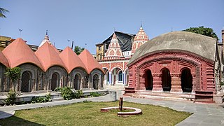
Berhampore is a city and a municipality in the state of West Bengal, India. As per the 2011 census, Berhampore has a population of 305,609 and is the seventh largest city in West Bengal. Berhampore is the administrative headquarters of the Murshidabad district. It is located about 200 km (124 mi) from Kolkata, the state capital. It is one of the most important business, administrative, educational and political hub of Bengal as well as of India. Congress Lok Sabha leader Shri Adhir Ranjan Chowdhury has been elected from this city since 1999. It is one of the most popular urban agglomerations of West Bengal state. It was the first centre of East India Company in India. Not only the British but also the Dutch and the French established their companies in this city and, as a result, it grew as a production hub of India. It is famous for its famous sweets such as Chanabora, Manohara, Rasgulla and many more. The city is divided into five administrative regions: Gora Bazar, Khagra, Indraprastha, Cossimbazar, Haridasmati. Berhampore was a part of Sepoy Mutiny of 1857 which took place at Berhampore Cantonment region. It was used by many foreign traders as their production hub. Before becoming a city many janpadas such as Saidabad; Farasdanga; Kalikapur had become famous. Cossimbazar had also become world famous for its muslin clothes. This city used to be the headquarters of Rajshahi administrative region till 1875.

Jiaganj Azimganj is a city and a municipality in Murshidabad district in the Indian state of West Bengal.

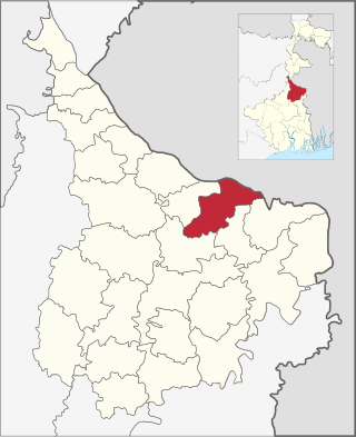
Murshidabad district is a district of in the Indian state of West Bengal. Situated on the left bank of the river Ganges, the district is very fertile. Covering an area of 5,341 km2 (2,062 sq mi) and having a population 7.103 million, it is a densely populated district and the ninth most populous in India. Berhampore city is the headquarters of the district.
Lalgola is a census town in the Lalgola CD block in the Lalbag subdivision of Murshidabad district, West Bengal. It is situated about 225 kilometres (140 mi) north of Kolkata, near the head of the Ganges delta. It is a terminal railway station on the Ranaghat-Lalgola branch line. The distance between Lalgola railway station and Krishnapur railway station is one of the shortest distance between two railway stations in India (1.7 km). It is also a border checkpoint but presently non functional due to some unknown reasons.

Nakashipara is a community development block that forms an administrative division in Krishnanagar Sadar subdivision of Nadia district in the Indian state of West Bengal.

Lalbag subdivision is an administrative subdivision of Murshidabad district in the state of West Bengal, India.

Suti I is a community development block that forms an administrative division in the Jangipur subdivision of Murshidabad district in the Indian state of West Bengal.

Bhagawangola I is a community development block that forms an administrative division in the Lalbag subdivision of Murshidabad district in the Indian state of West Bengal.

Domkal is a community development block that forms an administrative division in the Domkol subdivision of Murshidabad district in the Indian state of West Bengal.

Raninagar II is a community development block that forms an administrative division in the Domkol subdivision of Murshidabad district in the Indian state of West Bengal.

Raghunathganj II is a community development block that forms an administrative division in the Jangipur subdivision of Murshidabad district in the Indian state of West Bengal.
Bhagawangola II is a community development block that forms an administrative division in the Lalbag subdivision of Murshidabad district in the Indian state of West Bengal.

Lalgola is a community development block that forms an administrative division in the Lalbag subdivision of Murshidabad district in the Indian state of West Bengal.

Krishnanagar I is a community development block that forms an administrative division in Krishnanagar Sadar subdivision of Nadia district in the Indian state of West Bengal.

The Ranaghat–Krishnanagar City–Lalgola line is a 155 km (96 mi) long broad gauge railway line which connects Ranaghat Junction in the Nadia district with Lalgola in the Murshidabad district of the Indian state of West Bengal. The line runs up to the Bangladesh border near the Ganga river and is a part of the Sealdah railway division of the Eastern Railway zone.

Naldahari is a small village located in the Murshidabad district of the state of West Bengal, India. It is a part of Lalgola Block near the Indo-Bangladesh international border. It is situated about 225 kilometres (140 mi) north of Kolkata, near the head of the Ganges delta.
Krishnapur is a village in the Lalgola CD block in the Lalbag subdivision of Murshidabad district in the state of West Bengal, India.

