Salar, Murshidabad

Last updated

Salar
Census Town
West Bengal location map.svg
Red pog.svg
Salar
Location in West Bengal, India
India location map.svg
Red pog.svg
Salar
Salar (India)
Coordinates: 23°46′29″N88°06′09″E / 23.77482°N 88.102632°E / 23.77482; 88.102632
CountryFlag of India.svg  India
State West Bengal
District Murshidabad
Government
  Type Federal democracy
   MP Adhir Ranjan Chowdhury
   MLA Kamalesh Chatterjee
Area
  Total7.1492 km2 (2.7603 sq mi)
Population
 (2011)
  Total42,594
  Density6,000/km2 (15,000/sq mi)
Languages
  Official Bengali, English
Time zone UTC+5:30 (IST)
PIN
742401 (Salar)
Telephone/STD code03484
Vehicle registration WB57, WB58
Lok Sabha constituency Baharampur
Vidhan Sabha constituency Bharatpur
Website murshidabad.gov.in

Salar is a census town in the Bharatpur II CD block in the Kandi subdivision of Murshidabad district in the state of West Bengal, India.

Contents

Geography

Salar, Murshidabad
Cities, towns and locations in the Berhampore and Kandi subdivisions, Murshidabad district
M: municipal town, CT: census town, R: rural/ urban centre, H: historical centres
Owing to space constraints in the small map, the actual locations in a larger map may vary slightly

Location

Salar is located at 23°46′29″N88°06′09″E / 23.77482°N 88.102632°E / 23.77482; 88.102632 .

Area overview

The area shown in the map alongside, covering Berhampore and Kandi subdivisions, is spread across both the natural physiographic regions of the district, Rarh and Bagri. [1] [2] The headquarters of Murshidabad district, Berhampore, is in this area. [3] The ruins of Karnasubarna, the capital of Shashanka, the first important king of ancient Bengal who ruled in the 7th century, is located 9.6 kilometres (6.0 mi) south-west of Berhampore. [4] [5] [6] The entire area is overwhelmingly rural with over 80% of the population living in the rural areas. [7]

Note: The map alongside presents some of the notable locations in the subdivisions. All places marked in the map are linked in the larger full screen map.

Demographics

According to the 2011 Census of India, Salar had a total population of 42,594, of which 22,600 (53%) were males and 19,994 (47%) were females. Population in the age range 0–6 years was 11,095. The total number of literate persons in Salar was 31,499 (79.10% of the population over 6 years). Muslim population is more than Hindu population. [8]

Civic administration

Police station

Salar Police Station has jurisdiction over Bharatpur II CD Block.

Railway station

Salar Railway Station is controlled by Katwa GRP. [9]

CD Block headquarters

The headquarters of Bharatpur II CD block are located near 2 no. Railgate at Salar. The total Block area is 158.50 km2 (61.20 sq mi). Total villages are 51 villages and 7 G.P, Kagram, Salar, Simulia, Tenya–Baidyapur, Malihati, Salu and Talibpur. [10]

Infrastructure

According to the District Census Handbook, Murshidabad, 2011, Salar covered an area of 7.1492 km2. It had 18 km roads with open drains. The protected water-supply involved overhead tank, tap water from untreated source etc. It had 3,200 domestic electric connections, 100 road lighting points. Among the medical facilities it had 1 hospital, 1 family welfare centre, 1 veterinary hospital, 1 charitable hospital/ nursing home, 19 medicine shops. Among the educational facilities, it had 11 primary schools, 4 middle schools, 3 secondary schools, 2 senior secondary schools, 1 general degree college. It had 4 recognised shorthand, typewriting & vocational training institutes, 1 non-formal education centre (Sarva Shiksha Abhiyan). Among the social, recreational & cultural facilities it had 1 cinema theatre, 1 public library. It produced beedi, rice. It had the branch offices of 2 nationalised banks, 1 agricultural credit society, 3 non-agricultural credit societies. [11]

Economy

Banking and financial services

Transport

Train

Salar railway station is situated on the Howrah-Katwa-Azimganj line. It connects to the major cities like Kolkata, Siliguri, Guwahati, Dibrugarh, Rampurhat, Malda Town, Katihar, Kishanganj, Alipurduar. [12]

Bus

There is a bus terminus named Tridib Chaudhuri Bus Terminus. The Kandi-Katwa Road passes through It has good connection with Baharampore, Katwa, Bolpur, Bardhaman, Asansol.

A NBSTC bus started from Salar to Kolkata. NBSTC bus to Digha and Durgapur stops at Salar.

A private bus service to Siliguri is available from Salar.

Education

1.Salar Edward Zakariah Higher Secondary School, P.O. Salar, District: Murshidabad, West Bengal, India. 2. Salar K.K. Girls High School P.O. Salar, District: Murshidabad, West Bengal, India.³ salar Saleh memorial high school, post salar,district murshidabad

Colleges/ other institutions

Muzaffar Ahmed Mahavidyalaya was established in 1986 at Salar. Affiliated with the University of Kalyani it offers courses in Bengali, English, Sanskrit, Arabic, history, geography, political science, sociology and education.

High schools

Primary schools

Culture

The main festivals of Salar are:

Besides, there are three fair celebrations organized every year. The biggest fair is the Pilkhundi Fair. The other two are Muharram Fair and Mallickpara Fair.

Foods

Salar is famous in Murshidabad for delicious Muslim dishes like Seekh Kebab, Tanduri Roti, Halwa, Nalli Nihari, Liver, Brain Fry, Kofta, Tikkia, Mangso Kosha etc.

Healthcare

Salar Rural Hospital functions with 30 beds. Beside it, nearby hospital is Katwa sub-divisional Hospital and Kandi sub-divisional Hospital. [14]

Notable people

Related Research Articles

<span class="mw-page-title-main">Beldanga</span> Town in West Bengal, India

Beldanga is a municipality town under the Berhampore subdivision of Murshidabad district in the state of West Bengal, India. Beldanga is an important trade centre of this district.

Goaljan is a census town in the Berhampore CD block of the Berhampore subdivision in the Murshidabad district in the Indian state of West Bengal.

Gora Bazar is a census town located in the community development block of Berhampore, Berhampore subdivision, Murshidabad district, West Bengal, India. It is situated at an elevation of 18 meters above sea level.

Kandi is a sub-divisional city and a municipality in Murshidabad district in the Indian state of West Bengal. It is the headquarters of the Kandi subdivision and is located on the east bank of Kana Mayurakshi River. It is also known as the rice store of Murshidabad district, owing to its large production of rice. It is situated 30 km away from Berhampore, the district headquarter of Murshidabad and approximately 195 km from Kolkata, the capital of West Bengal.

<span class="mw-page-title-main">Kandi subdivision</span> Subdivision in West Bengal, India

Kandi subdivision is an administrative subdivision of Murshidabad district in the state of West Bengal, India.

<span class="mw-page-title-main">Karnasuvarna</span>

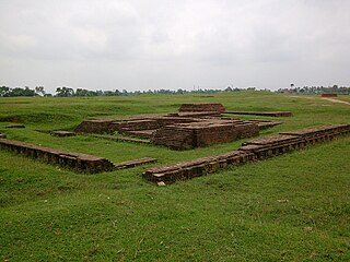
Karnasuvarna or Karnasubarna was an ancient city, located in the present day Berhampore CD block in the Berhampore subdivision of Murshidabad district, West Bengal, India. It was the capital of Gauda Kingdom.

Burwan is a village, with a police station, in the Burwan CD block in the Kandi subdivision of Murshidabad district in the state of West Bengal, India.

<span class="mw-page-title-main">Kandi (community development block)</span> Community development block in West Bengal, India

Kandi is a community development block that forms an administrative division in the Kandi subdivision of Murshidabad district in the Indian state of West Bengal.

<span class="mw-page-title-main">Bharatpur I</span> Community development block in West Bengal, India

Bharatpur I is a community development block that forms an administrative division in the Kandi subdivision of Murshidabad district in the Indian state of West Bengal.

<span class="mw-page-title-main">Bharatpur II</span> Community development block in West Bengal, India

Bharatpur II is a community development block that forms an administrative division in the Kandi subdivision of Murshidabad district in the Indian state of West Bengal.

Nagar is a village in the Khargram CD block in the Kandi subdivision of Murshidabad district in the state of West Bengal, India. It is located about 190 km from Kolkata, the state capital.

Gram Salkia is a village in the Burwan CD block in the Kandi subdivision of Murshidabad district in the state of West Bengal, India.

Bharatpur is a village in the Bharatpur I CD block in the Kandi subdivision of Murshidabad district in the state of West Bengal, India.

Saktipur is a village in the Beldanga II CD block in the Berhampore subdivision of Murshidabad district in the state of West Bengal, India. It is situated 35km away from district headquarter Baharampur.

Gokarna is a village in the Kandi CD block in the Kandi subdivision of Murshidabad district in the state of West Bengal, India.

Banjetia is a census town in the Berhampore CD block in the Berhampore subdivision of the Murshidabad district in the state of West Bengal, India.

Sibdanga Badarpur is a census town in the Berhampore CD block in the Berhampore subdivision of the Murshidabad district in the state of West Bengal, India.

Gopjan is a census town in the Berhampore CD block in the Berhampore subdivision of the Murshidabad district in the state of West Bengal, India.

Haridasmati is a census town in the Berhampore CD block in the Berhampore subdivision of the Murshidabad district in the state of West Bengal, India.

Barua is a census town in the Beldanga I CD block in the Berhampore subdivision of the Murshidabad district in the state of West Bengal, India.

References

  1. "District Census Handbook: Murshidabad, Series 20 Part XII A" (PDF). Physiography, Page 13. Directorate of Census Operations, West Bengal, 2011. Retrieved 24 July 2017.
  2. "Murshidabad". Geography. Murshidabad district authorities. Retrieved 24 July 2017.
  3. "Murshidabad". Murshidabad district authorities. Retrieved 12 September 2017.
  4. Ray, Nihar Ranjan, Bangalir Itihas Adi Parba, (in Bengali), 1980 edition, pp. 160-161, Paschim Banga Niraksharata Durikaran Samiti
  5. Sengupta, Nitish, History of the Bengali-speaking People, p.25, UBS Publishers’ Distributors Pvt. Ltd.
  6. Majumdar, Dr. R.C., History of Ancient Bengal, first published 1971, reprint 2005, pp. 5-6, Tulshi Prakashani, Kolkata, ISBN   81-89118-01-3.
  7. "District Census Handbook, Murshidabad, Series 20, Part XII B" (PDF). District Primary Census Abstract page 26. Directorate of Census Operations West Bengal. Retrieved 2 July 2021.
  8. "C.D. Block Wise Primary Census Abstract Data(PCA)". West Bengal – District-wise CD Blocks. Registrar General and Census Commissioner, India. Retrieved 27 August 2018.
  9. "District Statistical Handbook 2014 Murshidabad". Table 2.1. Department of Statistics and Programme Implementation, Government of West Bengal. Archived from the original on 29 July 2017. Retrieved 17 May 2017.
  10. "District Census Handbook: Murshidabad, Series 20 Part XII A" (PDF). Map of Murshidabad with CD Block HQs and Police Stations (on the fourth page). Directorate of Census Operations, West Bengal, 2011. Retrieved 27 August 2017.
  11. "District Census Handbook Murshidabad, Census of India 2011, Series 20, Part XII A" (PDF). Section II Town Directory, Pages 981-987: Statement I: Growth History, Pages 990-993: Statement III: Civic & Other Amenities, Pages 993-995: Statement IV: Medical Facilities 2009, Pages 995-1001 Section V: Educational, Recreational and Cultural Facilities; Pages 1 001- 1002: Statement VI: Industry & Banking. Directorate of Census Operations, West Bengal. Retrieved 26 June 2021.
  12. "73031 Katwa Azimganj DEMU". Time Table. indiarailinfo. Retrieved 9 August 2017.
  13. "Muzaffar Ahmed Mahavidyalaya". College Admission. Retrieved 12 September 2017.
  14. "Health & Family Welfare Department". Health Statistics. Government of West Bengal. Retrieved 19 September 2017.