Digha

Last updated

Digha
Coastal Town
Sunrise @ Digha.jpg
Sunrise at Digha
West Bengal location map.svg
Red pog.svg
Digha
Coordinates: 21°38′18″N87°30′35″E / 21.6384°N 87.5096°E / 21.6384; 87.5096
CountryIndia
State West Bengal
District Purba Medinipur
Sub Division Contai subdivision
Development AuthorityDigha Sankarpur Development Authority (DSDA)
Elevation
6 m (20 ft)
Languages
  Official Bengali
Time zone UTC+5:30 (IST)
Vehicle registration WB-31xxxx , WB-32xxxx
Lok Sabha constituency Kanthi
Vidhan Sabha constituency Ramnagar, Purba Medinipur
Website

Digha is a seaside resort town in the state of West Bengal, India. It lies in Purba Medinipur district and at the northern end of the Bay of Bengal. It has a low gradient with a shallow sand beach. It is a popular sea resort in West Bengal. [1]

Contents

History

Originally, there was a place called Beerkul, where Digha lies today. This name was referred in Warren Hastings's letters (1780) as Brighton of the East. [1]

An English businessman John Frank Snaith started living here in 1923 and his writings provided a good exposure to this place. [2] He convinced West Bengal Chief Minister Bidhan Chandra Roy to develop this place to be a beach resort. An old church can be seen near the main gate of Old Digha. This place is also known as Alankarpur. A new mission has been developed in New Digha which is known as Sindhur Tara which is beside Amrabati Park. It's a Church where it is possible to wish for the welfare of family and loved ones. The best way to visit is to book a local rickshaw. There are so many places where one can travel which give mental refreshments, like Tajpur, Odisha Border, Science City etc. [3] [1] [4]

Geography

Digha
Cities and towns in Contai subdivision of Purba Medinipur district
M: municipal city/ town, CT: census town, R: rural/ urban centre, H: historical/ religious centre, S: port, sea-beach
Owing to space constraints in the small map, the actual locations in a larger map may vary slightly

Location

Digha is located at 21°38′18″N87°30′35″E / 21.6384°N 87.5096°E / 21.6384; 87.5096 . It has an average elevation of 6 metres (20 ft).

It is located 183 km (114 mi) from Kolkata/Howrah via Mecheda and 234 km (145 mi) via Kharagpur, this proximity has probably helped this small hamlet to emerge as a weekend getaway with number of hotels and tourist lodges. Digha is connected to Kolkata/Howrah by a highway and a rail-link via Tamluk. Now many trains including Howrah-Digha Super AC express, Tamralipta express, Kandari express and EMU locals from Santragacchi via Mecheda and Tamluk run between Digha and Howarh and other stations in eastern India.It is also located under Contai Sub division.

Police stations

Digha police station has jurisdiction over part of Ramnagar I (part) CD Block. It covers an area of 3,153 km2 with a population of 35,054. It is located in old Digha. [5]

Digha Mohana Coastal police station is located in Digha. [6]

Urbanisation

93.55% of the population of Contai subdivision live in the rural areas. Only 6.45% of the population live in the urban areas and it is considerably behind Haldia subdivision in urbanization, where 20.81% of the population live in urban areas. [7]

Note: The map alongside presents some of the notable locations in the subdivision. All places marked in the map are linked in the larger full screen map.

Hospital

There is a District Hospital near old Digha which provides good medical facilities. There is Contai Sub divisional Hospital and Sanjiban Hospital 31 k.m from Digha.

Climate

There are mainly five seasons in Digha, namely summer, monsoon, autumn, winter and spring. Summer starts in April and continues until June with a maximum temperature of 37 °C (99 °F). Although cold wind from the sea keeps the weather pleasant in this time. Next comes monsoon in July and lasts till the end of September. Digha generally experiences an average rainfall with high humidity in the monsoon season. Autumn sets in October and lasts till mid of December with an average temperature of around 25 degree Celsius. The weather remains very pleasant this time. Winter sets in the second half of December and lasts till mid February with an average temperature of 15/16 degree Celsius. The spring is the most enjoyable season in Digha starting from mid February to mid April.[ citation needed ] The hotels remain full of their capacity as tourist inflow is the highest in this peak season. [3]

Climate data for Digha (1981–2010, extremes 1982–2009)
MonthJanFebMarAprMayJunJulAugSepOctNovDecYear
Record high °C (°F)32.9
(91.2)
36.0
(96.8)
38.0
(100.4)
41.3
(106.3)
42.0
(107.6)
39.0
(102.2)
37.3
(99.1)
36.0
(96.8)
36.2
(97.2)
38.2
(100.8)
34.5
(94.1)
32.5
(90.5)
42.0
(107.6)
Mean daily maximum °C (°F)25.5
(77.9)
27.8
(82.0)
30.7
(87.3)
32.1
(89.8)
32.9
(91.2)
32.5
(90.5)
31.5
(88.7)
31.2
(88.2)
31.5
(88.7)
31.4
(88.5)
29.6
(85.3)
27.0
(80.6)
30.3
(86.5)
Mean daily minimum °C (°F)14.0
(57.2)
18.0
(64.4)
22.6
(72.7)
25.5
(77.9)
26.6
(79.9)
26.7
(80.1)
26.4
(79.5)
26.2
(79.2)
25.9
(78.6)
23.7
(74.7)
18.7
(65.7)
14.3
(57.7)
22.4
(72.3)
Record low °C (°F)7.6
(45.7)
8.8
(47.8)
12.6
(54.7)
17.9
(64.2)
18.3
(64.9)
20.8
(69.4)
20.4
(68.7)
21.4
(70.5)
21.0
(69.8)
15.8
(60.4)
9.8
(49.6)
8.8
(47.8)
7.6
(45.7)
Average rainfall mm (inches)14.0
(0.55)
25.7
(1.01)
32.9
(1.30)
42.4
(1.67)
138.9
(5.47)
299.6
(11.80)
259.1
(10.20)
309.3
(12.18)
330.7
(13.02)
187.4
(7.38)
52.8
(2.08)
3.4
(0.13)
1,696.1
(66.78)
Average rainy days1.01.82.22.96.210.713.114.312.26.71.90.373.2
Average relative humidity (%) (at 17:30 IST)68717478798182828177716776
Source: India Meteorological Department [8] [9]

Transport

Bus service

There is frequent bus service to Digha from Dharmatala, Baruipur Garia and Joka bus stand of Kolkata, Burdwan, Bolpur, Siliguri, Asansol, Kirnahar, Baharampur, Serampore, Tarakeswar and many other parts of West Bengal. Buses are available from Howrah as well, a connection has been made from Sealdah to Digha where a private bus arrives at 8:30 am throughout the week. It takes the shortest route from Sealdah connecting S.N Banerjee road, Taltala, Wellington, Dharmatala to Howrah station, it departs from Howrah Station within 5 min to Digha. Digha is connected to Kolkata Metropolitan Area with E17 (Barasat), E17/1 (Barasat), E19 (Habra), E19D (Dumdum station), E45 (Joka), E46 (Saltlake Karunamoyee), E54 (Sreerampore), E55 (Madhyamgram), E56 (Baduria), ACT5 (Barasat), ACT8 (Habra), ACT9 (Saltlake Karunamoyee), ST31 (Dharmatala) etc. [10]

Train service

In 2004, train services have started for Digha railway station (Station Code : DGHA). There was a one DMU service from Santragachi railway station but it discontinued. Now there are three new trains from Howrah Station too.

Train NameStart <-> Destination
Tamralipta Express HWH <-> DGHA
Paharia Express NJP <-> DGHA
Vishakapatnam - Digha SF Express VSKP <-> DGHA
Kandari Express HWH <-> DGHA
Malda Town - Digha Express MLDT <-> DGHA
Asansol - Digha Express ASN <-> DGHA
Puri Digha Superfast Express Puri <-> DGHA
Mecheda LocalMCA <-> DGHA
Panskura LocalPKU <-> DGHA

Air

Area

Hotels at Talasari, New Digha Road, Gadadharpur, Purba Medinipur. Hotels at Talasari, New Digha Road.jpg
Hotels at Talasari, New Digha Road, Gadadharpur, Purba Medinipur.

Digha's old beach is not as wide as it used to be due to heavy soil erosion. Big stones and concrete steps are used to hold together the beach. Another problem is the record number of storm surges that have caused many of the unplanned shacks and smaller hotels to succumb to the sea. Since it is one of very few popular beaches in West Bengal, it gets overcrowded, especially during the cooler winter break.[ citation needed ]

A new beach has been developed "New Digha" which is about 2 km (1.2 mi) from the old beach. This new beach is not only bigger than the old one, but might be considered a better one.[ citation needed ] It is clean and well-maintained and is not surrounded by a congested locality like the older beach. The latest attraction of New Digha is the Science Centre established by the National Council of Science Museums. The entire stretch of the Digha seaface from Old Digha to New Digha is filled with casuarina plantations.[ citation needed ]

Places of interest

Marine Aquarium and Research Centre (MARC)

It was established in the year 1989 during the Seventh Five Year Plan. The major objective of the Centre is to display the marine biodiversity of the region and impart its values to the common people and to carryout the research activities.

Shiva Temple At Chandaneswar

This place is only 8 km (5.0 mi) away from Digha the century-old Temple of Shiva at Chandaneswar, near Bengal and Orissa Border. Chandaneswar is part of Odisha. During the Bengali month of Chaitra, an annual fair is organised here. Nearly half million people and pilgrims visit the temple.

Old Digha

New Digha

Around Digha

Related Research Articles

<span class="mw-page-title-main">Purba Medinipur district</span> District in West Bengal, India

Purba Medinipur district is an administrative unit in the Indian state of West Bengal. It is the southernmost district of Medinipur division – one of the five administrative divisions of West Bengal. The headquarters in Tamluk. It was formed on 1 January 2002 after the Partition of Medinipur into Purba Medinipur and Paschim Medinipur which lies at the northern and western border of it. The state of Odisha is at the southwest border; the Bay of Bengal lies in the south; the Hooghly river and South 24 Parganas district to the east; Howrah district to the north-east; Paschim Medinipur district to the west.

<span class="mw-page-title-main">Mecheda</span> Town in West Bengal, India

Mecheda is a town in Shahid Matangini Block in West Bengal, India. The town is the entrance point of Purba Medinipur district which lies upon the South Eastern Railway Zone and in proximity to Haldia, Tamluk, Digha and Contai, Egra.

<span class="mw-page-title-main">Contai</span> City in West Bengal, India

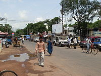
Contai is a coastal and subdivisional city and a municipality in Purba Medinipur district, West Bengal, India. It is the headquarters of the Contai subdivision. It is the second most populated city of the district.According to the geologists, the present geographical dimension of Contai came into existence with the great natural disaster of the third century AD (flood), which created Chilka lake out of the Chilka Bay. Kanthi, that is Contai, means "sand-bound reefs" or sand walls. The name Contai may thus be an English expression of the local jargon meaning "sand heaps".

<span class="mw-page-title-main">Ramnagar I</span> Community development block in West Bengal, India

Ramnagar I is a community development block that forms an administrative division in Contai subdivision of Purba Medinipur district in the Indian state of West Bengal.

<span class="mw-page-title-main">Bhagabanpur I</span> Community development block in West Bengal, India

Bhagabanpur I is a community development block that forms an administrative division in Egra subdivision of Purba Medinipur district in the Indian state of West Bengal.

<span class="mw-page-title-main">Shankarpur</span> Rural in West Bengal, India

Shankarpur is a beach village located 14 km east of Digha in West Bengal, India. It is also a regular fishing harbour. Shankarpur contains a number of temples.

<span class="mw-page-title-main">Kolaghat (community development block)</span> Community development block in West Bengal, India

Kolaghat is a community development block that forms an administrative division in Tamluk subdivision of Purba Medinipur district in the Indian state of West Bengal.

Chandipur is a village, in Chandipur CD block in Tamluk subdivision of Purba Medinipur district in the state of West Bengal, India.

<span class="mw-page-title-main">Contai I</span> Community development block in West Bengal, India

Contai I is a community development block that forms an administrative division in Contai subdivision of Purba Medinipur district in the Indian state of West Bengal.

<span class="mw-page-title-main">Bhogpur railway station</span> Railway station in West Bengal, India

The Bhogpur railway station is situated in Bhogpur in the district of Purba Medinipur in West Bengal in the South Eastern Railway Zone, India. The station lies between Howrah and Kharagpur. Special EMU trains are available here, and local EMU trains Howrah–Panskura, Howrah–Balichak, Howrah–Kharagpur, Howrah–Medinipur, Howrah–Haldia stop here. Also a few MEMU and passenger trains are available here, MEMU trains to TATA, BELDA are available here. Also trains to Digha and Puri also stop here. One pair of Santragachi–Digha and Mecheda–Digha trains are available here. The station has four platforms.

<span class="mw-page-title-main">Tajpur, West Bengal</span> Seaside tourist spot in West Bengal, India

Tajpur is located in Purba Medinipur, in the state of West Bengal, India on the shore of Bay of Bengal. Tajpur is set between Mandarmani and Shankarpur. Tajpur is 172.9 km via NH16 and NH116B from the state capital Kolkata. It is located under Contai Sub division area.

<span class="mw-page-title-main">Bargabhima Temple</span> Temple in Tamluk, West Bengal

Bargabhima Temple is a Hindu ancient temple situated at Tamluk in Purba Medinipur district of West Bengal.

Shipur is a fast growing village under Egra I community development block of Purba Medinipur district in the state of West Bengal, India. Famous for its annual Charak Puja, this village has well-developed social facilities like schools, post office, market, co-operative society, telecommunication, ATM, playground, children's park etc. A health centre is also functioning in this village. As per Constitution of India and Panchayati Raj Act, Shipur village is administrated by Sarpanch who is the elected representative of village. Shipur is under the administration of Sahara Gram Panchayat.

<span class="mw-page-title-main">State Highway 4 (West Bengal)</span>

State Highway 4 is a state highway in West Bengal, India.

Nandakumar is a village in Nandakumar CD block in Tamluk subdivision of Purba Medinipur district in the state of West Bengal, India.

<span class="mw-page-title-main">Ramnagar, Purba Medinipur</span> Township in West Bengal, India

Ramnagar is a Township Area, in Ramnagar I CD block in Contai subdivision of Purba Medinipur district in the state of West Bengal, India.

<span class="mw-page-title-main">Sahid Matangini railway station</span> Railway station in West Bengal, India

The Sahid Matangini railway station in the Indian state of West Bengal, serves Tamluk-Panskura Road, Tamluk, India in Purba Medinipur district. It is on the Panskura–Haldia line. It is 88 km (55 mi) from Howrah Station and 21 km (13 mi) from Panskura.

<span class="mw-page-title-main">Tamluk Junction railway station</span> Railway station in West Bengal, India

The Tamluk Junction railway station in the Indian state of West Bengal, serves Tamluk, India in Purba Medinipur district. It is on the Panskura–Haldia line. It is under the jurisdiction of South Eastern Railway zone. Tamluk Junction railway station is one of the busiest railway stations of Kharagpur railway division. It is 91 km (57 mi) from Howrah station and 24 km (15 mi) from Panskura.

<span class="mw-page-title-main">Kanthi railway station</span> Railway station in West Bengal, India

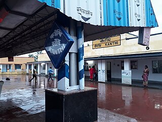
Kanthi railway station is a railway station on the Tamluk–Digha branch line of South Eastern Railway zone of Indian Railways. The railway station is situated beside Kanthi Bypass Road at Contai in Purba Medinipur district in the Indian state of West Bengal. The distance between Howrah and this railway station is approximately 152 km. Number of Express and passengers trains stop at Kanthi railway station.

<span class="mw-page-title-main">Deshapran railway station</span> Railway station in West Bengal, India

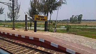
Deshapran railway station is a railway station on the Tamluk–Digha branch line of South Eastern Railway zone of Indian Railways. The railway station is situated beside Contai–Nandakumar Road, at Bajkul in Purba Medinipur district in the Indian state of West Bengal. This railway station is named after Bengali nationalist Deshapran Birendranath Sasmal. It serves Bajkul, Kismat Bajkul, Kajlagarh, Tethi Bari, Hincha Gerya, Kalaberia and other places in Bhagabanpur I CD block.

References

  1. 1 2 3 "Digha page in National Informatics Centre site". Archived from the original on 7 February 2006. Retrieved 2 April 2006.
  2. বীরকূল পরগনার গ্রামই আজকের দীঘা Anandabazar Patrika. Retrieved 5 September 2021
  3. 1 2 "About the Place, Digha Sankarpur development Authority" . Retrieved 20 December 2012.
  4. "West Bengal Tourishm, Digha". Archived from the original on 26 June 2012. Retrieved 29 October 2012.
  5. "Digha PS". Purba Medinipur District Police. Archived from the original on 16 November 2016. Retrieved 10 November 2016.
  6. "Digha Mohana Coastal PS". Purba Medinipur District Police. Archived from the original on 12 November 2016. Retrieved 10 November 2016.
  7. "District Statistical Handbook 2014 Purba Medinipur". Table 2.2. Department of Planning and Statistics, Government of West Bengal. Retrieved 22 April 2019.
  8. "Station: Digha Climatological Table 1981–2010" (PDF). Climatological Normals 1981–2010. India Meteorological Department. January 2015. pp. 251–252. Archived from the original (PDF) on 5 February 2020. Retrieved 10 January 2021.
  9. "Extremes of Temperature & Rainfall for Indian Stations (Up to 2012)" (PDF). India Meteorological Department. December 2016. p. M234. Archived from the original (PDF) on 5 February 2020. Retrieved 10 January 2021.
  10. Transport Department, Government of West Bengal: Bus Services