List of districts of West Bengal

Last updated

Districts of West Bengal WestBengalDistricts numbered.svg
Districts of West Bengal

The Himalayas lies in the north of West Bengal and the Bay of Bengal is at the south. Between them, the river Ganga flows eastwards and its main distributary, the Hooghly River, flows south to reach the Bay of Bengal. The Siliguri Corridor, which connects North-East India with rest of the India, lies in the North Bengal region of the state. Geographically, West Bengal is divided into a variety of regions—Darjeeling Himalayan hill region, Terai and Dooars region, North Bengal plains, Rarh region, Western plateau and high lands, coastal plains, Sundarbans and the Ganga Delta. [1]

Contents

In 1947, when India gained independence, the state of West Bengal was formed, with 14 districts, as per partition plan of the then Bengal province of British India. [2] [3] The former princely state Koch Bihar joined as a district on 26 January 1950, [4] and the former French enclave Chandannagore joined as part of the Hooghly district in 1954. [5] The States Reorganisation Act of 1956 led to addition of Purulia district to the state and to enlargement of West Dinajpur district. [6] Later, larger districts such as West Dinajpur, 24 Parganas and Midnapore were bifurcated.

West Bengal is now divided into 23 districts which includes the newly formed Alipurduar district (formed on 25 June 2014), Kalimpong district (formed on 14 February 2017), Jhargram district (formed on 4 April 2017), and the splitting of the former Bardhaman district into Purba Bardhaman district and Paschim Bardhaman district (formed on 7 April 2017). The districts are grouped into five divisions. [7] [8]

Divisions are administered by Divisional Commissioners. [9] Kolkata, the capital of the state, constitutes the Kolkata district. Other districts are further divided into administrative units such as subdivisions and blocks, administered by SDO and BDO, respectively. The Panchayati Raj has a three-tier structure in the state. The atomic unit is called a Gram Panchayat, which is the Panchayat organisation for a collection of villages. [10] The block-level organisations are called Panchayat Samiti, [11] and the district-level organisations are named Zilla Parishad. [12]

The West Bengal cabinet has approved the creation of seven new districts on 1 August 2022. This will number district from 23 to 30. [13] New Sundarban District from existing South 24 Parganas District, new Ichhamati District and Basirhat District from existing North 24 Parganas District. New Ranaghat District from existing Nadia District and Bishnupur District from existing Bankura district. While new Jangipur District and Berhampore district from existing Murshidabad District will be carved out.

Geography

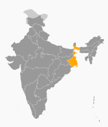
West Bengal is bordered by three countries: Nepal, Bhutan and Bangladesh; and five Indian states: Sikkim, Bihar, Jharkhand, Odisha, and Assam. Sikkim and Bhutan are located to the north of the state, Nepal to the northwest, Bihar and Jharkhand in the west, Odisha in the southwest, the Bay of Bengal to the south, and Bangladesh and Assam are in the east. West Bengal is the only state of India that has both snowy mountains (Himalayas in the north) and sea beaches (on the coast of the Bay of Bengal in the south). In between them, the river Ganga enters the state from west, before it branches off into its main distributaries: the Hooghly River, which flows southwards to reach the Bay of Bengal, and the Padma River, which flows eastwards into Bangladesh.

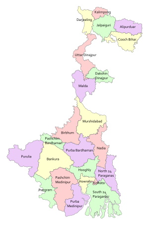
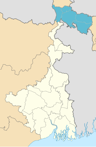
The districts that are located at the north of the Ganga—Darjeeling, Jalpaiguri, Cooch Behar, Malda, Uttar Dinajpur, Dakshin Dinajpur, Alipurduar and Kalimpong — are often referred to collectively as North Bengal. Kalimpong is a newly added district of West Bengal. [1] Geographically, this area is divided into the Darjeeling Himalayan hill region, the Terai and Dooars region, and the North Bengal plains. [1] The Siliguri Corridor, also known as Chicken's Neck, which connects North-East India with rest of the India, lies in this region. The Indo-Bangladesh enclaves are either enclaves or exclaves of the Cooch Behar district or the Jalpaiguri district. [14]

The districts on the south of the Ganges—Bankura, Paschim Bardhaman, Purba Bardhaman, Birbhum, Purulia, Murshidabad, Nadia, West Midnapore, Jhargram, East Midnapore, Hooghly, Howrah, Kolkata, North 24 Parganas and South 24 Parganas—constitute a variety of geographical regions such as the Rarh region, the Western plateau and high lands, the coastal plains, the Sunderbans and the Ganga Delta. [1] Kolkata, the capital of the state, constitutes the Kolkata district.

The uninhabited South Talpatti Island, which surfaced in the Bay of Bengal in the 1970s near the Indo-Bangladesh border, is claimed by both India and Bangladesh. [15]

History

After India gained independence in 1947, the province of Bengal was partitioned along religious lines. The western part remained in India (and was named West Bengal) while the eastern part joined newly formed Pakistan as a province called East Pakistan (later giving rise to Bangladesh in 1971). [2] At the time of its creation in 1947, the state of West Bengal was divided into 14 districts—Bankura, Birbhum, Burdwan, Calcutta (Kolkata), Darjeeling, Jalpaiguri, Hooghly, Howrah, Malda, Midnapore, Murshidabad, Nadia, West Dinajpur and 24 Parganas. [3] Cooch Behar district was a princely state named Koch Bihar till 20 August 1949, when the state formally agreed to join India. Transfer of administration was started on 12 September 1949 and was completed on 19 January 1950, when Cooch Behar became a district of West Bengal. [4] Chandannagar, which was earlier part of the French India, had voted to join India in a plebiscite in 1949. Formally, it joined India in 1952 and finally became a part of the Hooghly district of West Bengal on 2 October 1954. [5] The States Reorganisation Act of 1956 reorganised boundaries of the Indian states along linguistic lines. As this act was implemented, the then West Dinajpur district was enlarged with the addition of some areas from Bihar, and the Purulia district was formed on 1 November 1956 from parts of the Manbhum district of Bihar. [6]

Later, some large districts were divided into smaller districts. On 1 March 1986, the district of 24 Parganas was bifurcated into two districts—the North 24 Parganas district and the South 24 Parganas district. [16] On 1 April 1992, the West Dinajpur district was bifurcated into the Uttar Dinajpur district and the Dakshin Dinajpur district. [17] [18] On 1 January 2002, the erstwhile Midnapore district was bifurcated into the Purba Medinipur district and the Paschim Medinipur district. [19]

Since 2007, the demand for a separate Gorkhaland state has been revived by the Gorkha Janmukti Morcha and its supporters in the Darjeeling hills. [20] The Kamtapur People's Party and its supporters' movement for a separate Kamtapur state that covers the North Bengal has also gained momentum in the 2000s. [21]

Administrative structure

Divisions of West Bengal Divisions of West Bengal.svg
Divisions of West Bengal

A district is governed by a District Collector, who is better known as a District Magistrate (DM) in the state of West Bengal. [22] A DM is an officer from either Indian Administrative Service (IAS) or West Bengal Civil Service (WBCS), and is appointed by the State Government of West Bengal. [22] Each district is divided into subdivisions, except the Kolkata district, which contains urban area only, administered by Kolkata Municipal Corporation. A subdivision is governed by a sub-divisional magistrate (SDM), better known as a Sub-Divisional Officer (SDO). [23] Other than urban units such as town municipalities, a subdivision contains 'community development blocks' (also known as CD blocks or blocks or Tehsil or Taluka). A block consists of urban units such as census towns and rural units called gram panchayats. A block is administered by a Block Development Officer (BDO),who is similar as Tehsildar and who is appointed by the Government of West Bengal. [22]

A gram panchayat, which consists of a group of villages, is administered by a village council headed by a Pradhan . [10] As per the West Bengal Panchayat Act, 1973, each Block has a Panchayat Samiti, whose members include the Pradhans of the constituent gram panchayats, and the MLAs from the block. [11] A Panchayat Samiti is headed by a Sabhapati. [24] The third tier of the Panchayati Raj is Zilla Parishad, a district level organisation with the Sabhapatis of the constituent Panchayat Samitis and the MLAs from the district as its members. [12] A Zilla Parishad is headed by a Sabhadhipati. [25] For the Darjeeling district, the Zilla Parishad has ceased to exist, but a similar organisation for the Siliguri subdivision exists, which is designated as a Mahakuma Parishad. [26]

The Gorkha Hill Council, formed in 1988, administers three (out of four) subdivisions of the Darjeeling district: Darjeeling Sadar, Kalimpong and Kurseong. [27] Gorkha Hill Council manages the departments of Public Health, Education, Public Works, Transport, Tourism, Market, Small scale industries, Agriculture, Agricultural waterways, Forest (except reserved forests), Water, Livestock, Vocational Training and Sports and Youth services. [28] District administration of Darjeeling, which is still responsible for election, panchayat, law and order, revenue etc., also acts as an interface between the Council and the State Government. [28]

A District Superintendent of Police, better known as a Superintendent of Police, heads the District Police organisation of West Bengal Police. This is as per the Police Act of 1861, which is applicable to the whole of India. [29] The Superintendents of Police are officers of the Indian Police Service. [30] For every subdivision, there is a Subdivision Police, headed by a Police officer of the rank of Assistant Superintendent of Police or Deputy Superintendent of Police. [31] Under subdivisions, there are Police Circles, each headed by an Inspector of Police. [31] A Police Circle consists of Police Stations, each headed by an Inspector of Police, or in case of rural areas, by a Sub-Inspector of Police. [31]

The Calcutta High Court has the jurisdiction of the state of West Bengal. Though most of the districts have more courts other than a District Court, not every subdivision of the state has a Court. [32]

A group of districts forms a division, which is administered by a 'Divisional Commissioner'. West Bengal is now divided in twenty three districts, grouped under five divisions: [9]

Malda division Burdwan division Jalpaiguri division Presidency division Medinipur division

Alphabetical listing of West Bengal Districts

Sl no.Code [33] DistrictHeadquarters [34] Established [35] Subdivisions [9] Area [36] Population 2011 [36] Population Density Map
1AD Alipurduar Alipurduar 2014 [19] 3,383 km2 (1,306 sq mi)1,491,250441/km2 (1,140/sq mi) Alipurduar in West Bengal (India).svg
2BN Bankura Bankura 19476,882 km2 (2,657 sq mi)3,596,674523/km2 (1,350/sq mi)
Bankura in West Bengal (India).svg
3BR Paschim Bardhaman Asansol 20171,603.17 km2 (618.99 sq mi)2,882,0311,798/km2 (4,660/sq mi)
Paschim Bardhaman in West Bengal (India).svg
4BR Purba Bardhaman Bardhaman 20175,432.69 km2 (2,097.57 sq mi)4,835,532890/km2 (2,300/sq mi)
Purba Bardhaman in West Bengal (India).svg
5BI Birbhum Suri 19474,545 km2 (1,755 sq mi)3,502,404771/km2 (2,000/sq mi)
Birbhum in West Bengal (India).svg
6KB Cooch Behar Cooch Behar 1950 [4] 3,387 km2 (1,308 sq mi)2,819,086833/km2 (2,160/sq mi)
Cooch Behar in West Bengal (India).svg
7DA Darjeeling Darjeeling 19472,092.5 km2 (807.9 sq mi)1,595,181732/km2 (1,900/sq mi)
Darjeeling in West Bengal (India).svg
8DD Dakshin Dinajpur Balurghat 1992 [18] 2,219 km2 (857 sq mi)1,676,276755/km2 (1,960/sq mi)
Dakshin Dinajpur in West Bengal (India).svg
9HG Hooghly Chinsura 19473,149 km2 (1,216 sq mi)5,519,1451,753/km2 (4,540/sq mi)
Hooghly in West Bengal (India).svg
10HR Howrah Howrah 19471,467 km2 (566 sq mi)4,850,0293,306/km2 (8,560/sq mi)
Howrah in West Bengal (India).svg
11JP Jalpaiguri Jalpaiguri 19472,844 km2 (1,098 sq mi)2,381,596837/km2 (2,170/sq mi)
Jalpaiguri in West Bengal (India).svg
12JH Jhargram Jhargram 2017 [4] 3,037.64 km2 (1,172.84 sq mi)1,136,548374/km2 (970/sq mi)
Jhargram in West Bengal (India).svg
13KO Kolkata Kolkata 1947 Kolkata 185 km2 (71 sq mi)4,496,69424,306/km2 (62,950/sq mi)
Kolkata in West Bengal (India).svg
14KA Kalimpong Kalimpong 2017 [19] 1,044 km2 (403 sq mi)251,642241/km2 (620/sq mi)
Kalimpong in West Bengal (India).svg
15MA Malda English Bazar 19473,733 km2 (1,441 sq mi)3,988,8451,069/km2 (2,770/sq mi)
Malda in West Bengal (India).svg
16ME Paschim Medinipur Medinipur 2002 [19] 6,308 km2 (2,436 sq mi)4,776,909757/km2 (1,960/sq mi)
Paschim Medinipur in West Bengal (India).svg
17ME Purba Medinipur Tamluk 2002 [19] 4,736 km2 (1,829 sq mi)5,095,8751,076/km2 (2,790/sq mi)
Purba Medinipur in West Bengal (India).svg
18MU Murshidabad Baharampur 19475,324 km2 (2,056 sq mi)7,103,8071,334/km2 (3,460/sq mi)
Murshidabad in West Bengal (India).svg
19NA Nadia Krishnanagar 19473,927 km2 (1,516 sq mi)5,167,6011,316/km2 (3,410/sq mi)
Nadia in West Bengal (India).svg
20PN North 24 Parganas Barasat 1986 [16] 4,094 km2 (1,581 sq mi)10,009,7812,445/km2 (6,330/sq mi)
North 24 Parganas in West Bengal (India).svg
21PS South 24 Parganas Alipore 1986 [16] 9,960 km2 (3,850 sq mi)8,161,961819/km2 (2,120/sq mi)
South 24 Parganas in West Bengal (India).svg
22PU Purulia Purulia 1956 [6] 6,259 km2 (2,417 sq mi)2,930,115468/km2 (1,210/sq mi)
Purulia in West Bengal (India).svg
23UD Uttar Dinajpur Raiganj 1992 [17] 3,140 km2 (1,210 sq mi)3,007,134958/km2 (2,480/sq mi)
Uttar Dinajpur in West Bengal (India).svg
Total236988,752 km2 (34,267 sq mi)91,347,7361,029/km2 (2,670/sq mi)
West Bengal located in India India WB.svg
West Bengal located in India

Demographics

The following is a list of the basic demographic data for the districts of West Bengal at the time of the 2011 census by their population rank in India [38]

RankDistrict (West Bengal)Population (2011 census)Bengali (Bangla) SpeakersPercentage (%) of Bengali SpeakersGrowth RateSex RatioLiteracyDensity/KM
1 Uttar 24 Parganas (Dumdum Naihati Barrackpore)10,009,7818,899,69688.91%12.8695584.532,445
2 Dakshin 24 Parganas (Sundarban)8,161,9617,984,03097.82%18.1795677.51819
3 Murshidabad 7,103,8076,996,53998.49%21.0995866.591,334
4 Paschim Medinipur (Kharagpur)5,913,4575,153,57787.15%14.4496079.04636
5 Hooghly (Bandel)5,519,1454,828,69987.49%9.4995882.551,753
6 Nadia (Nabadwip)5,167,6005,065,28198.02%12.2494775.581,316
7 Purba Medinipur (Haldia)5,095,8755,009,75498.31%15.3293687.661,076
8 Howrah 4,850,0294,122,03984.99%13.3193583.853,300
9 Purba Bardhaman (Burdwan)4,841,6324,495,93992.86%11.9294576.211,099
10 Kolkata 4,496,6942,763,21861.45%−1.6790886.3124,306
11 Malda 3,988,8453,631,44491.04%21.5093962.711,071
12 Jalpaiguri (New Jalpaiguri)3,872,8462,539,03765.56%13.7795473.79621
13 Bankura 3,596,6743,261,46390.68%12.6495470.95523
14 Birbhum (Bolpur)3,502,4043,235,52092.38%16.1595670.90771
15 Uttar Dinajpur 3,007,1342,046,65568.06%22.9093660.13956
16 Purulia 2,930,1152,360,50080.56%15.4395565.38468
17 Paschim Bardhaman (Asansol Durgapur Raniganj)2,882,0311,676,76558.18%11.9294576.211,099
18 Cooch Behar 2,819,0862,672,21194.79%13.8694275.49833
19 Darjeeling (Siliguri Bagdogra)1,846,823489,59226.51%14.4797179.92585
20 Dakshin Dinajpur 1,676,2761,414,94484.41%11.1695473.86753

Economy

The following is a list of basic economic data for the districts of West Bengal as of 2013–2014, the latest year for which data is available: [39]

DistrictGross District Domestic Product (as of 2013–14, at Constant (2004–05) Prices)Gross District Domestic Product Per Capita (as of 2013–14, at Constant (2004–05) Prices)
Bardhaman 38,923.07 crore (equivalent to 1.3 trillionorUS$17 billion in 2023)40,634.07 (equivalent to 140,000orUS$1,700 in 2023)
Birbhum 10,291 crore (equivalent to 350 billionorUS$4.4 billion in 2023)25,426.29 (equivalent to 86,000orUS$1,100 in 2023)
Bankura 11,729.33 crore (equivalent to 400 billionorUS$5.0 billion in 2023)28,345.12 (equivalent to 96,000orUS$1,200 in 2023)
Purba Medinipur 26,978.96 crore (equivalent to 920 billionorUS$11 billion in 2023)44,654.60 (equivalent to 150,000orUS$1,900 in 2023)
Paschim Medinipur 18,930.11 crore (equivalent to 640 billionorUS$8.1 billion in 2023)27,575.49 (equivalent to 94,000orUS$1,200 in 2023)
Howrah 22,817.15 crore (equivalent to 780 billionorUS$9.7 billion in 2023)39,313.99 (equivalent to 130,000orUS$1,700 in 2023)
Hooghly 24,371.33 crore (equivalent to 830 billionorUS$10 billion in 2023)35,920.65 (equivalent to 120,000orUS$1,500 in 2023)
Uttar 24 Parganas 48,035.5 crore (equivalent to 1.6 trillionorUS$20 billion in 2023)37,010.24 (equivalent to 130,000orUS$1,600 in 2023)
Dakshin 24 Parganas 29,238.58 crore (equivalent to 990 billionorUS$12 billion in 2023)29,745.60 (equivalent to 100,000orUS$1,300 in 2023)
Kolkata 36,031.93 crore (equivalent to 1.2 trillionorUS$15 billion in 2023)67,993.29 (equivalent to 230,000orUS$2,900 in 2023)
Nadia 18,205.56 crore (equivalent to 620 billionorUS$7.7 billion in 2023)29,006.54 (equivalent to 99,000orUS$1,200 in 2023)
Murshidabad 21,280.12 crore (equivalent to 720 billionorUS$9.1 billion in 2023)25,416.46 (equivalent to 86,000orUS$1,100 in 2023)
Jalpaiguri 14,240.17 crore (equivalent to 480 billionorUS$6.1 billion in 2023)29,692.58 (equivalent to 100,000orUS$1,300 in 2023)
Darjeeling 10,664.32 crore (equivalent to 360 billionorUS$4.5 billion in 2023)45,808.78 (equivalent to 160,000orUS$1,900 in 2023)
Uttar Dinajpur 6,843 crore (equivalent to 230 billionorUS$2.9 billion in 2023)18,836.95 (equivalent to 64,000orUS$800 in 2023)
Dakshin Dinajpur 4,955.3 crore (equivalent to 170 billionorUS$2.1 billion in 2023)23,599.48 (equivalent to 80,000orUS$1,000 in 2023)
Malda 12,023.94 crore (equivalent to 410 billionorUS$5.1 billion in 2023)25,412.24 (equivalent to 86,000orUS$1,100 in 2023)
Cooch Behar 7,895.18 crore (equivalent to 270 billionorUS$3.4 billion in 2023)24,973.51 (equivalent to 85,000orUS$1,100 in 2023)
Purulia 8,340.2 crore (equivalent to 280 billionorUS$3.5 billion in 2023)24,749.26 (equivalent to 84,000orUS$1,100 in 2023)
West Bengal 371,795.04 crore (equivalent to 13 trillionorUS$160 billion in 2023)36,293.33 (equivalent to 120,000orUS$1,500 in 2023)

See also

Related Research Articles

<span class="mw-page-title-main">Cooch Behar district</span> District in West Bengal, India

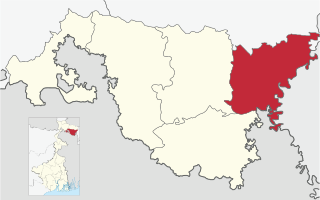
Cooch Behar district is a district of the Indian state of West Bengal.

<span class="mw-page-title-main">Howrah district</span> District in West Bengal, India

Howrah district is a district of the West Bengal state in eastern India. Howrah district is one of the highly urbanized area of West Bengal. It has thousands of years of rich heritage in the form of the great Bengali kingdom of Bhurshut. The district is named after its headquarters, the city of Howrah.

<span class="mw-page-title-main">North Bengal</span> Northern part of Bengal covering India and Bangladesh

North Bengal is a term used for the north-western part of Bangladesh and northern part of West Bengal. The Bangladesh part denotes the Rajshahi Division and Rangpur Division. Generally, it is the area lying west of Jamuna River and north of Padma River and includes the Barind Tract. The West Bengal part denotes Jalpaiguri Division and the Malda division together. The Bihar parts include the Kishanganj district. It also includes parts of Darjeeling Hills. Traditionally, the Ganga River divides Bengal into South Bengal and North Bengal, divided again into Terai and Dooars regions. Jalpesh and jatileswar are some of the most popular sacred places.

<span class="mw-page-title-main">Geography of West Bengal</span> Overview of the geography of the Indian state

The Geography of West Bengal, a state in eastern India, is primarily defined by plains and plateaus, with the high peaks of the Himalayas in the north and the Bay of Bengal to the south.

<span class="mw-page-title-main">University of North Bengal</span> Public university in Siliguri, West Bengal, India

University of North Bengal is a public state collegiate major research university in North Bengal region of West Bengal, which is located in Raja Rammohanpur, Siliguri, Darjeeling district, in the Indian state of West Bengal. A second campus is in Danguajhar, Jalpaiguri in Jalpaiguri district and a third campus is in Salt Lake, Kolkata also in West Bengal. The university was established in 1962 to fill growing manpower needs in the six North Bengal districts and the neighbouring state of Sikkim. North Bengal University offers degrees in undergraduate, post-graduate taught-research, doctorate and post doctoral programs.

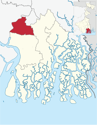
Kulpi is a village and a gram panchayat within the jurisdiction of the Kulpi police station in the Kulpi CD block in the Diamond Harbour subdivision of the South 24 Parganas district in the Indian state of West Bengal.

<span class="mw-page-title-main">2008 H5N1 outbreak in West Bengal</span> Bird flu outbreak in India

The 2008 bird flu outbreak in West Bengal was an occurrence of avian influenza in West Bengal, India which began on January 16, 2008. The infection was caused by the H5N1 subtype of the Influenza A virus and impacted at least thirteen districts, including Birbhum, Nadia, Murshidabad, Burdwan, Hooghly, Cooch Behar, Malda, Bankura, Purulia, Howrah, West Midnapore, South 24 Parganas and South Dinajpur. A range of precautions has been instituted including a large cull of chickens, eggs, and poultry birds, the imposition of segregation zones, and a disinfection programme for the plant. The government put a blanket ban on the movement of poultry birds from West Bengal.

<span class="mw-page-title-main">Jalpaiguri division</span> Division in West Bengal, India

Jalpaiguri Division is one of the 5 divisions in the Indian state of West Bengal. It is the northernmost division of West Bengal. It is surrounded by Nepal on the western side, Bihar on South-Western side, Bhutan on the Northern side and Bangladesh on the southern side.

<span class="mw-page-title-main">Tufanganj subdivision</span> Subdivision in West Bengal, India

Tufanganj subdivision is a subdivision of the Cooch Behar district in the state of West Bengal, India.

<span class="mw-page-title-main">Alipore Sadar subdivision</span> Subdivision in West Bengal, India

Alipore Sadar subdivision is an administrative subdivision of the South 24 Parganas district in the Indian state of West Bengal.

<span class="mw-page-title-main">Barrackpore subdivision</span> Subdivision in West Bengal, India

Barrrackpore subdivision is an administrative subdivision of the North 24 Parganas district in the Indian state of West Bengal.

<span class="mw-page-title-main">Dinhata I</span> Community development block in West Bengal, India

Dinhata I is a community development block that forms an administrative division in the Dinhata subdivision of the Cooch Behar district in the Indian state of West Bengal.

<span class="mw-page-title-main">Dinhata II</span> Community development block in West Bengal, India

Dinhata II is a community development block that forms an administrative division in the Dinhata subdivision of the Cooch Behar district in the Indian state of West Bengal.

<span class="mw-page-title-main">Mathabhanga II</span> Community development block in West Bengal, India

Mathabhanga II is a community development block that forms an administrative division in the Mathabhanga subdivision of the Cooch Behar district in the Indian state of West Bengal.

<span class="mw-page-title-main">Outline of West Bengal</span> Overview of and topical guide to West Bengal

The following outline is provided as an overview of and topical guide to West Bengal:

Bamanhat is a neighbourhood and a gram panchayat in the Dinhata II CD block in the Dinhata subdivision of the Cooch Behar district, West Bengal, India.

Gitaldaha is a village and a gram panchayat in the Dinhata I CD block in the Dinhata subdivision of the Cooch Behar district in the state of West Bengal, India.

Changrabandha is a census town and a gram panchayat in Mekhliganj CD block in Mekhliganj subdivision of Cooch Behar district in the state of West Bengal, India. It is a border checkpoint on the Bangladesh-India border.

<span class="mw-page-title-main">CID West Bengal</span> Premier Investigation Agency of West Bengal

Criminal Investigation Department (CID) is the premier investigation agency of the State of West Bengal, India. In Bengal, Criminal Investigation Department (CID) came into existence on 1 April 1906 under Mr. C. W. C. Plowden. The first head of CID after Independence was H.N. Sarkar, IPJP. The Headquarter of CID is situated at Bhabani Bhaban, 31 Belvedere Road, Alipore, Kolkata. At present, CID West Bengal is headed by R. Rajasekaran, IPS, Addl. Director General of Police.

The 2022 Bidhannagar Municipal Corporation election was held on 12 February 2022 to elect 41 members of the Bidhannagar Municipal Corporation (BMC) which governs Bidhannagar, the Satellite city of the capital city of Indian state of West Bengal, Kolkata in the district of North 24 Parganas.

References

  1. 1 2 3 4 David Christiana (1 September 2007). "Arsenic Mitigation in West Bengal, India: New Hope for Millions" (PDF). Southwest Hydrology. p. 32. Archived from the original (PDF) on 5 March 2016. Retrieved 20 December 2008.
  2. 1 2 Harun-or-Rashid (2012). "Partition of Bengal, 1947". In Islam, Sirajul; Jamal, Ahmed A. (eds.). Banglapedia: National Encyclopedia of Bangladesh (Second ed.). Asiatic Society of Bangladesh.
  3. 1 2 Chatterji, Joya (2007). The Spoils of Partition: Bengal and India, 1947–1967. Cambridge University Press. p. 58. ISBN   978-0-521-87536-3 . Retrieved 8 December 2008.
  4. 1 2 3 4 "Brief History of Cooch Behar". Official website of Cooch Behar District. Archived from the original on 24 July 2011. Retrieved 10 September 2008.
  5. 1 2 "States of India since 1947". World Statesmen website. Archived from the original on 18 June 2008. Retrieved 7 November 2008.
  6. 1 2 3 "District profile". Official website of Purulia District. Archived from the original on 9 December 2009. Retrieved 18 November 2008.
  7. "The Statesman: Alipurduar to become Bengal's 20th dist". Archived from the original on 14 July 2014. Retrieved 21 June 2014.
  8. "Roy Alipurduar: Alipurduar a new district on June 25 | Kolkata News – Times of India". The Times of India .
  9. 1 2 3 "Directory of District, Sub division, Panchayat Samiti/ Block and Gram Panchayats in West Bengal, March 2008". West Bengal. National Informatics Centre, India. 19 March 2008. Archived from the original on 25 February 2009. Retrieved 19 November 2008.
  10. 1 2 "Section 9 of West Bengal Panchayat Act, 1973". Department of Panchayat and Rural Department, West Bengal. Archived from the original on 10 April 2009. Retrieved 9 December 2008.
  11. 1 2 "Section 94 of West Bengal Panchayat Act, 1973". Department of Panchayat and Rural Department, West Bengal. Archived from the original on 10 April 2009. Retrieved 9 December 2008.
  12. 1 2 "Section 140 of West Bengal Panchayat Act, 1973". Department of Panchayat and Rural Department, West Bengal. Archived from the original on 10 April 2009. Retrieved 9 December 2008.
  13. "Explained: 7 new districts in West Bengal — how and why are districts created or abolished in India?". The Indian Express. 1 August 2022. Retrieved 2 August 2022.
  14. Evgeny Vinokurov (2005). "Theory of Enclaves, Chapter 6: Enclave stories and case studies" (PDF). Evgeny Vinokurov's website. p. 17. Archived from the original (PDF) on 27 July 2007. Retrieved 20 December 2008.
  15. A.G. Noorani (31 August 2001). "Of Indo-Bangladesh distrust". Frontline magazine. Archived from the original on 26 March 2009. Retrieved 29 December 2008.{{cite web}}: CS1 maint: unfit URL (link)
  16. 1 2 3 Mandal, Asim Kumar (2003). The Sundarbans of India: A Development Analysis. Indus Publishing. pp. 168–169. ISBN   81-7387-143-4 . Retrieved 4 September 2008.
  17. 1 2 "Home page". Official website of Uttar Dinajpur District. Retrieved 1 September 2008.
  18. 1 2 "Historical Perspective". Official website of South Dinajpur District. Retrieved 1 September 2008.
  19. 1 2 3 4 5 Jana, Naresh (31 December 2001). "Tamluk readies for giant's partition". The Telegraph (Kolkata). Archived from the original on 13 August 2004. Retrieved 1 September 2008.
  20. "Call for Gorkhaland renewed". Darjeeling Times. 7 October 2007. Archived from the original on 22 December 2008. Retrieved 11 December 2008.
  21. Indo Asian News Service (25 June 2008). "West Bengal faces another blockade, this time for Kamtapur state". AOL India News. Archived from the original on 29 March 2009. Retrieved 11 December 2008.
  22. 1 2 3 "Section 2 of West Bengal Panchayat Act, 1973". Department of Panchayat and Rural Department, West Bengal. Retrieved 9 December 2008.[ permanent dead link ]
  23. Ramesh Kumar Arora, Ramesh Kumar Arora Rajni Goyal (1995). Indian Public Administration: Institutions and Issues. New Age Publishers. p. 298. ISBN   81-7328-068-1 . Retrieved 9 December 2008.
  24. "Section 98 of West Bengal Panchayat Act, 1973". Department of Panchayat and Rural Department, West Bengal. Archived from the original on 10 April 2009. Retrieved 9 December 2008.
  25. "Section 143 of West Bengal Panchayat Act, 1973". Department of Panchayat and Rural Department, West Bengal. Archived from the original on 10 April 2009. Retrieved 9 December 2008.
  26. "Section 185 of West Bengal Panchayat Act, 1973". Department of Panchayat and Rural Department, West Bengal. Archived from the original on 10 April 2009. Retrieved 9 December 2008.
  27. "Memoranda of Settlement – DGHC". Darjeeling Times. Archived from the original on 29 March 2009. Retrieved 11 December 2008.
  28. 1 2 "History of Darjeeling: Darjeeling-Today". Official website of Darjeeling District. Retrieved 29 December 2008.
  29. "The Police Act, 1861". India Code Legislative Department. Retrieved 14 December 2008.
  30. "Indian Police Service (Uniform) Rules". Ministry of Personnel, Public Grievances and Pensions, Government of India. Archived from the original on 10 April 2009. Retrieved 14 December 2008.
  31. 1 2 3 "Police Organisation of India" (PDF). Commonwealth Human Rights Initiative. p. 9. Retrieved 14 December 2008.
  32. "Different Courts in West Bengal (Other than High Courts, Kolkata)". Judicial Department, Government of West Bengal. Archived from the original on 26 March 2009. Retrieved 14 December 2008.
  33. "NIC Policy on format of e-mail Address: Appendix (2): Districts Abbreviations as per ISO 3166–2" (PDF). Ministry Of Communications and Information Technology, Government of India. 18 August 2004. pp. 5–10. Archived from the original (PDF) on 11 September 2008. Retrieved 24 November 2008.
  34. "Districts : West Bengal". Government of India portal. Retrieved 24 November 2008.
  35. Here 'Established' means year of establishment as a district of West Bengal. The state of West Bengal was established in 1947 with 14 districts of erstwhile Bengal province of British India.
  36. 1 2 "Area, Population, Decennial Growth Rate and Density for 2001 and 2011 at a glance for West Bengal and the Districts" (XLS). 2011 census of India. Retrieved 13 December 2012.
  37. "We are developing Purulia as a tourism hub: Mamata Banerjee : All India Trinamool Congress". Archived from the original on 16 December 2017. Archived 13 January 2020 at the Wayback Machine
  38. "Indian Districts by Population, Growth Rate, Sex Ratio 2011 Census". Registrar General & Census Commissioner, India. Retrieved 6 April 2013.
  39. Department of Statistics and Programme Implementation, Government of West Bengal (6 May 2016). "State Domestic Product and District Domestic Product of West Bengal 2014–15" (PDF).