Siliguri subdivision

Last updated

Siliguri subdivision
Subdivision
Siliguri (subdivision) in Darjeeling (West Bengal).svg
Coordinates: 26°43′N88°25′E / 26.72°N 88.41°E / 26.72; 88.41
CountryFlag of India.svg  India
State West Bengal
District Darjeeling
Headquarters Siliguri
Government
  BodyMunicipal Corporation (urban)
Mahakuma Parisad (rural)
Languages
  Official Bengali [1] [2]
  Additional official English [1]
Time zone UTC+5:30 (IST)
ISO 3166 code IN-WB
Vehicle registration WB
Website www.siliguri.gov.in

Siliguri subdivision is a subdivision of the Darjeeling district in the state of West Bengal, India.

Contents

Subdivisions

Darjeeling district is divided into the following administrative subdivisions: [3] [4]

Darjeeling Subdivision Map (en).svg
SubdivisionHeadquarters
Area
km2
Population
(2011)
Rural %
(2011)
Urban %
(2011)
Darjeeling Sadar Darjeeling 921.68429,39161.0039.00
Kurseong Kurseong 377.35136,79358.4141.59
Mirik Mirik 125.6857,88780.1119.89
Siliguri Siliguri 802.01971,12055.1144.89
Darjeeling district Darjeeling 2,226.721,595,19157.8942.11
Siliguri subdivision
Places in the North-eastern portion of Siliguri subdivision in Darjeeling district
CT: census town, R: rural/ urban centre, MC: municipal corporation, F: facilities
Abbreviations used in names – TG for Tea Garden, Jn RS for Junction Railway Station
New Jalpaiguri Junction railway station is in Jalpaiguri district
Owing to space constraints in the small map, the actual locations in a larger map may vary slightly
Siliguri subdivision
Places in the south-western portion of Siliguri subdivision in Darjeeling district
CT: census town, R: rural/ urban centre, F: facilities
Owing to space constraints in the small map, the actual locations in a larger map may vary slightly

Police stations

Police stations in the Siliguri subdivision have the following features and jurisdiction: [5] [6] [3]

Police StationArea covered
km2
International border
Inter-state border
km
Municipal TownCD block
Naxalbari n/a*-- Naxalbari
Kharibari n/a***- Kharibari
Phansidewa n/a*-- Phansidewa
Matigara n/a/--- Matigara
Bagdogra n/a-- Siliguri -
Pradhan Nagar n/a-- Siliguri -
Siliguri n/a-- Siliguri -
Siliguri Women n/a-- Siliguri -

.* The total length of border with Nepal (Mechi River) is 101.02 km (62.77 mi). The total length ofborder with Bangladesh (Mahananda River) is 19.32 km (12.00 mi). .**The total length of border with Bihar is 48.30 km (30.01 mi)

Gram panchayats

Gram panchayats in Siliguri subdivision are : [7]

Blocks

Community development blocks in Siliguri subdivision are: [4] [8] [9]

Darjeeling Tehsil Map (en).svg
CD blockHeadquartersArea
km2
Population
(2011)
SC  % ST  %Literacy
Rate %
Census
Towns
Naxalbari Naxalbari 181.88165,52326.7819.5775.476
Kharibari Kharibari 144.88109,25153.6119.4667.372
Phansidewa Phansidewa 312.15204,52229.6830.6164.46-
Matigara Bairatisal 143.00197,27835.7513.4274.766

Demographics

Religion in Siliguri sub-division (2011) [10]

   Hinduism (82.78%)
   Islam (9.42%)
   Christianity (6.33%)
   Buddhism (0.78%)
  Others (0.69%)

According to the 2011 census, Hindus numbered 803,888 and formed 82.78% of the population. Muslims numbered 91,478 and formed 9.42% of the population. Christians numbered 61,477 and formed 6.33% of the population. Buddhists numbered 7,534 and formed 0.78% of the population. Others numbered 6,733 and formed 0.69% of the population.

Education

Given in the table below (data in numbers) is a comprehensive picture of the education scenario in Darjeeling district, with data for the year 2012-13. [11]

SubdivisionPrimary
School
Middle
School
High
School
Higher Secondary
School
General
College, Univ
Technical /
Professional Instt
Non-formal
Education
InstitutionStudentInstitutionStudentInstitutionStudentInstitutionStudentInstitutionStudentInstitutionStudentInstitutionStudent
Darjeeling Sadar 57937,345288,0193722,5792316,49279,51061,0951,14228,425
Kurseong 21813,03137212810,59697,78312,034486636714,261
Mirik 787,211391962,13122,1271715--30920,265
Siliguri67679,713308,5854623,90367100,8451013,398133,1611,79396,766
Darjeeling district 1,551137,3006418,24411759,290101127,2471925,657235,1223,611159,717

Note: Primary schools include junior basic schools; middle schools, high schools and higher secondary schools include madrasahs; technical schools include junior technical schools, junior government polytechnics, industrial technical institutes, industrial training centres, nursing training institutes etc.; technical and professional colleges include engineering colleges, medical colleges, para-medical institutes, management colleges, teachers training and nursing training colleges, law colleges, art colleges, music colleges etc. Special and non-formal education centres include sishu siksha kendras, madhyamik siksha kendras, centres of Rabindra mukta vidyalaya, recognised Sanskrit tols, institutions for the blind and other handicapped persons, Anganwadi centres, reformatory schools etc. [11]

Educational institutions

The following institutions are located in Siliguri subdivision:

Healthcare

The table below (all data in numbers) presents an overview of the medical facilities available and patients treated in the hospitals, health centres and sub-centres in 2013 in Darjeeling district, with data for the year 2012-13.: [25]

SubdivisionHealth & Family Welfare Deptt, WB Other
State
Govt
Deptts
Local
bodies
Central
Govt
Deptts /
PSUs
NGO /
Private
Nursing
Homes
TotalTotal
Number
of
Beds
Total
Number
of
Doctors*
Indoor
Patients
Outdoor
Patients
Hospitals
Rural
Hospitals
Block
Primary
Health
Centres
Primary
Health
Centres
Darjeeling Sadar 32161--3167293222,584149,465
Kurseong 41-3--1-9554229,097132,488
Mirik -103----442442,35457,243
Siliguri33141-447631,146168133,0861,738,671
Darjeeling district 1072162-550922,471266167,1211,738.671

.* Excluding nursing homes.

Medical facilities

Medical facilities in Siliguri subdivision are as follows:

Hospitals: (Name, location, beds) [26]

Rural Hospitals: (Name, CD block, location, beds) [27]

Block Primary Health Centres: (Name, CD block, location, beds) [28]

Primary Health Centres : (CD block-wise)(CD block, PHC location, beds) [29]

Legislative segments

As per order of the Delimitation Commission in respect of the delimitation of constituencies in the West Bengal, the ward no. 1 to 30 and 45 to 47 of the Siliguri municipal corporation will constitute the Siliguri assembly constituency of West Bengal. [30] The Phansidewa block and the Kharibari block constitute the Phansidewa assembly constituency. The three villages of Sitong Forest, Sivok Hill Forest and Sivok Forest under the Champasari gram panchayat of the Matigara block will be part of Kurseong assembly constituency. Rest of the area under the Matigara block and the area under the Naxalbari block will constitute the MatigaraNaxalbari assembly constituency. The Phansidewa constituency will be reserved for Scheduled tribes (ST) candidates. The MatigaraNaxalbari constituency will be reserved for Scheduled castes (SC) candidates. All these four constituencies will be part of the Darjeeling Lok Sabha constituency. [31]

Related Research Articles

<span class="mw-page-title-main">Bagdogra</span> Census town in West Bengal, India

Bagdogra is a settlement in the Naxalbari CD block in the Siliguri subdivision of the Darjeeling district, in the Indian state of West Bengal. It is a part of the Greater Siliguri Metropolitan Area. Bagdogra is well connected by air to six major cities of India – Delhi, Mumbai, Bengaluru, Hyderabad, Kolkata and Chennai through the Bagdogra Airport. The Bagdogra railway station is also well connected.

Naxalbari is a village in the Naxalbari CD block in the Siliguri subdivision of the Darjeeling district in the state of West Bengal, India. Naxalbari is known for being the site of a 1967 revolt that would eventually led to the Naxalite–Maoist insurgency.
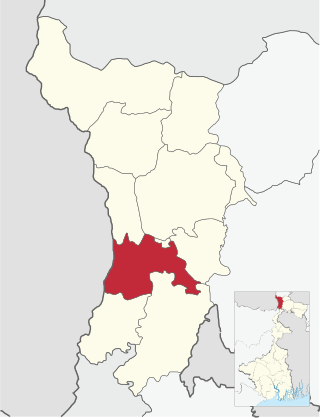
<span class="mw-page-title-main">Malbazar subdivision</span> Subdivision in West Bengal, India

Malbazar subdivision is an administrative division of the Jalpaiguri district in the Indian state of West Bengal.

<span class="mw-page-title-main">Phansidewa</span> Community development block in West Bengal, India

Phansidewa is a community development block that forms an administrative division in the Siliguri subdivision of the Darjeeling district in the Indian state of West Bengal.

<span class="mw-page-title-main">Kalimpong subdivision</span> Subdivision in West Bengal, India

The Kalimpong subdivision is the sole subdivision of the Kalimpong district in the state of West Bengal, India. It was initially formed as a subdivision of the Darjeeling district in 1916 under British India. On 14 February 2017 the subdivision was promoted to a district, becoming an independent Kalimpong district. The subdivision has its headquarters at Kalimpong Town and consists of the hilly areas annexed from Bhutan at the end of the Anglo-Bhutanese War in 1865.

<span class="mw-page-title-main">Bankura Sadar subdivision</span> Subdivision in West Bengal, India

Bankura Sadar subdivision is a subdivision of the Bankura district in the state of West Bengal, India.

<span class="mw-page-title-main">Bishnupur subdivision</span> Subdivision in West Bengal, India

Bishnupur subdivision is a subdivision of the Bankura district in the state of West Bengal, India.

<span class="mw-page-title-main">Rampurhat subdivision</span> Subdivision in West Bengal, India

Rampurhat subdivision is an administrative subdivision of Birbhum district in the state of West Bengal, India.

<span class="mw-page-title-main">Cooch Behar Sadar subdivision</span> Subdivision in West Bengal, India

Cooch Behar Sadar subdivision is a subdivision of the Cooch Behar district in the state of West Bengal, India.

<span class="mw-page-title-main">Mekhliganj subdivision</span> Subdivision in West Bengal, India

Mekhliganj subdivision is one of five subdivisions of the Cooch Behar district in the state of West Bengal, India. It has an area of 459.78 km2. As of 2011, it has a population of 282,750 of which 90.09% are rural and 9.91 are urban.

<span class="mw-page-title-main">Tufanganj subdivision</span> Subdivision in West Bengal, India

Tufanganj subdivision is a subdivision of the Cooch Behar district in the state of West Bengal, India.

<span class="mw-page-title-main">Arambag subdivision</span> Subdivision in West Bengal, India

Arambag subdivision is an administrative subdivision of the Hooghly district in the Indian state of West Bengal.

<span class="mw-page-title-main">Kharagpur subdivision</span> Subdivision in West Bengal, India

Kharagpur subdivision is an administrative subdivision of Paschim Medinipur district in the state of West Bengal, India.

<span class="mw-page-title-main">Baruipur subdivision</span> Subdivision in West Bengal, India

Baruipur subdivision is an administrative subdivision of the South 24 Parganas district in the Indian state of West Bengal.

<span class="mw-page-title-main">Diamond Harbour subdivision</span> Subdivision in West Bengal, India

Diamond Harbour subdivision is an administrative subdivision of the South 24 Parganas district in the Indian state of West Bengal.

<span class="mw-page-title-main">Kakdwip subdivision</span> Subdivision in West Bengal, India

Kakdwip subdivision is an administrative subdivision of the South 24 Parganas district in the Indian state of West Bengal.

<span class="mw-page-title-main">Canning subdivision</span> Subdivision in West Bengal, India

Canning subdivision is an administrative subdivision of the South 24 Parganas district in the Indian state of West Bengal.

<span class="mw-page-title-main">Matigara (community development block)</span> Community development block in West Bengal, India

Matigara is a community development block that forms an administrative division in the Siliguri subdivision of the Darjeeling district in the Indian state of West Bengal.

<span class="mw-page-title-main">Naxalbari (community development block)</span> Community development block in West Bengal, India

Naxalbari is a community development block that forms an administrative division in the Siliguri subdivision of the Darjeeling district in the Indian state of West Bengal.

<span class="mw-page-title-main">Manbazar subdivision</span> Subdivision in West Bengal, India

Manbazar subdivision is a subdivision of the Purulia district in the state of West Bengal, India.

References

  1. 1 2 "Fact and Figures". www.wb.gov.in. Retrieved 10 March 2019.
  2. "52nd REPORT OF THE COMMISSIONER FOR LINGUISTIC MINORITIES IN INDIA" (PDF). nclm.nic.in. Ministry of Minority Affairs. p. 85. Archived from the original (PDF) on 25 May 2017. Retrieved 10 March 2019.
  3. 1 2 "Darjeeling". District Profile - General Information. District administration. Retrieved 25 February 2020.
  4. 1 2 "District Statistical Handbook 2013 Darjeeling". Tables 2.2, 2.4b. Department of Planning and Statistics, Government of West Bengal. Retrieved 16 January 2020.
  5. "District Statistical Handbook 2013 Darjeeling". Tables 2.1, 2.2. Department of Statistics and Programme Implementation, Government of West Bengal. Retrieved 22 February 2020.
  6. "District Profile - Darjeeling". District administration. Retrieved 22 February 2020.
  7. "Egiye Bangla Darjeeling" (PDF). Miscellaneous - District Detail. District administration. Retrieved 25 February 2020.
  8. "CD block Wise Primary Census Abstract Data(PCA)". 2011 census: West Bengal – District-wise CD blocks. Registrar General and Census Commissioner, India. Retrieved 12 February 2020.
  9. "District Census Handbook: Darjiling" (PDF). Map of District Darjiling with CD block HQs and Police Stations (on the fifth page). Directorate of Census Operations, West Bengal, 2011. Retrieved 12 February 2020.
  10. 2011 Census censusindia.gov.in [ dead link ]
  11. 1 2 "District Statistical Handbook 2013 Darjeeling". Tables 4.4. Department of Statistics and Programme Implementation, Government of West Bengal. Retrieved 26 February 2020.
  12. "University of North Bengal". NBU. Retrieved 24 February 2020.
  13. "Siliguri College". SC. Retrieved 27 February 2020.
  14. "Siliguri Mahila Mahabidyalaya". Siliguri Mahila Mahabidyalaya. Retrieved 27 February 2020.
  15. "Achaya Prafulla Chandra Roy Government College". APCRGC. Retrieved 27 February 2020.
  16. "Siliguri College of Commerce". SCC. Retrieved 27 February 2020.
  17. "Munshi Premchand Mahaviyalaya". MPM. Retrieved 27 February 2020.
  18. "Gyan Jyoti College". GJC. Retrieved 27 February 2020.
  19. "Kalipada Ghosh Tarai Mahavidyalaya". KGTM. Retrieved 24 February 2020.
  20. "Kalipada Ghosh Tarai Mahavidyalaya". Careers360. Retrieved 24 February 2020.
  21. "Nakshalbari College". NC. Retrieved 27 February 2020.
  22. "Indian Institute of Legal Studies". IILS. Retrieved 27 February 2020.
  23. "North Bengal Medical College and Hospital". NBMCH. Retrieved 27 February 2020.
  24. "North Bengal Dental College". WBUHS. Retrieved 27 February 2020.
  25. "District Statistical Handbook 2013 Darjeeling". Tables 3.1, 3.3. Department of Statistics and Programme Implementation, Government of West Bengal. Retrieved 26 February 2020.
  26. "Health & Family Welfare Department" (PDF). Health Statistics - Hospitals. Government of West Bengal. Retrieved 27 February 2020.
  27. "Health & Family Welfare Department" (PDF). Health Statistics – Rural Hospitals. Government of West Bengal. Retrieved 27 February 2020.
  28. "Health & Family Welfare Department" (PDF). Health Statistics – Block Primary Health Centres. Government of West Bengal. Retrieved 27 February 2020.
  29. "Health & Family Welfare Department" (PDF). Health Statistics – Primary Health Centres. Government of West Bengal. Retrieved 27 February 2020.
  30. The other 14 wards of the Siliguri municipal corporation are located in the Jalpaiguri Sadar subdivision.
  31. "Press Note, Delimitation Commission" (PDF). Assembly Constituencies in West Bengal. Delimitation Commission. pp. 5–6, 23. Retrieved 10 January 2009.