Batasi

Last updated

Batasi
Village
TEA GARDEN 1.jpg
Tea Estate at Batasi
West Bengal location map.svg
Red pog.svg
Batasi
India location map.svg
Red pog.svg
Batasi
Coordinates: 26°35′58″N88°10′49″E / 26.5995°N 88.1804°E / 26.5995; 88.1804 Coordinates: 26°35′58″N88°10′49″E / 26.5995°N 88.1804°E / 26.5995; 88.1804
CountryFlag of India.svg  India
State West Bengal
District Darjeeling
Subdivision Siliguri
Government
  TypeDarjeeling
  BodyRaniganjpanishali G.P
Area
  Total9.7 km2 (3.7 sq mi)
Elevation
3.5 m (11.5 ft)
Time zone UTC+5:30 (IST)
PIN
734427/734428
Telephone code+91-05522
Vehicle registration WB

Batashi is a village in Kharibari CD block in Siliguri subdivision of Darjeeling district of West Bengal, India. [1]

Contents

The nearest railway station to Batasi is Batasi railway station, which is around 1 km away and is now well connected with the Indian Railway Network.

Geography

Places in the south-western portion of Siliguri subdivision in Darjeeling district
CT: census town, R: rural/ urban centre, F: facilities
Owing to space constraints in the small map, the actual locations in a larger map may vary slightly

Location

Batashi is located at 26°35′58″N88°10′49″E / 26.5995°N 88.1804°E / 26.5995; 88.1804 . [2]

Shyamdhan is shown as a census town in the map of Kharibari CD block on page 363 of the District Census Handbook, Darjiling, 2011. Batasi was not identified as a separate populated place in the 2011 census. [3]

The stretch of land lies in the Terai region at the base of the Himalayas. To the west, across the border river Mechi lies Nepal. The entire stretch of the land is covered by farm lands, tea estates and forests and small villages, consists of an area of 198.02 km2 (76.46 sq mi). The Gram area (village councils), viz. Batashi, Shyamdhan, Gondogol, Kungurpur, Bodra jote, West Bora jote, Budsing, Shebaeram, Hatkhola.

Area overview

The map alongside shows the Siliguri subdivision of Darjeeling district. This area is spread across the foothills of the Himalayas and is a plain land gently sloping from north to south. While the northern part is mentioned as the Terai region, the larger southern portion forms the western part of the Dooars region. While 55.11% per cent of the population resides in the rural areas, 44.89% resides in the urban areas. On the western side the Mechi River forms a long border with Nepal. On the eastern side the Mahananda River forms a short border with Bangladesh. [4] [5]

Note: The map alongside presents some of the notable locations in the subdivision. All places marked in the map are linked in the larger full screen map.

Transport

There is a station at Batasi on the Katihar-Siliguri line. It is 31.6 km (19.6 mi) from Siliguri. [6]

Education

Batashi has two[ clarification needed ] major government high schools, one for males and one for females, and there are many public and private primary schools.

Related Research Articles

Naxalbari Village in West Bengal, India

Naxalbari is a village in the Naxalbari CD block in the Siliguri subdivision of the Darjeeling district in the state of West Bengal, India. Naxalbari is famous for being the site of a 1967 revolt that would eventually lead to the Naxalite–Maoist insurgency.

Bairatisal Census Town in West Bengal, India

Bairatisal is a census town in the Matigara CD block in the Siliguri subdivision of Darjeeling district in the state of West Bengal, India.

Uttar Bagdogra Census Town in West Bengal, India

Uttar Bagdogra is a census town in the Siliguri subdivision of the Darjeeling district in the Indian state of West Bengal.
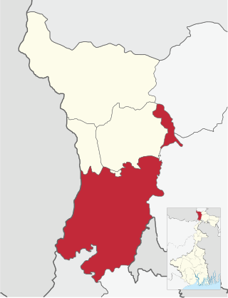
Kharibari (community development block) Community development block in West Bengal, India

Kharibari is a community development block that forms an administrative division in the Siliguri subdivision of the Darjeeling district in the Indian state of West Bengal.

Naxalbari (community development block) Community development block in West Bengal, India

Naxalbari is a community development block that forms an administrative division in the Siliguri subdivision of the Darjeeling district in the Indian state of West Bengal.

Kharibari Census Town in West Bengal, India

Kharibari is a census town in the Kharibari CD block in the Siliguri subdivision of the Darjeeling district in the state of West Bengal, India.

Matigarahat Village in West Bengal, India

Matigarahat is a village in the Matigara CD block in the Siliguri subdivision of the Darjeeling district in the state of West Bengal, India.

Shyamdhan Census Town in West Bengal, India

Shyamdhan is a census town in the Kharibari CD block in the Siliguri subdivision of Darjeeling district in the state of West Bengal, India.

Mohorgon Tea Garden Village in West Bengal, India

Mohurgong & Gulma Tea Estates is a tea garden in the Matigara CD block in the Siliguri subdivision of Darjeeling district in the state of West Bengal, India.

Kalkut, Siliguri Census Town in West Bengal, India

Kalkut is a census town in the Matigara CD block in the Siliguri subdivision of Darjeeling district in the state of West Bengal, India.

Tari, Siliguri Census Town in West Bengal, India

Tari is a census town in the Matigara CD block in the Siliguri subdivision of Darjeeling district in the state of West Bengal, India.

Jitu, Siliguri Census Town in West Bengal, India

Jitu is a census town in the Matigara CD block in the Siliguri subdivision of Darjeeling district in the state of West Bengal, India.

Mathapari Census Town in West Bengal, India

Mathapari is a census town in the Matigara CD block in the Siliguri subdivision of Darjeeling district in the state of West Bengal, India.

Bara Mohansingh Census Town in West Bengal, India

Bara Mohansingh is a census town in the Matigara CD block in the Siliguri subdivision of Darjeeling district in the state of West Bengal, India.

Dumriguri Census Town in West Bengal, India 26.708032 88.326167

Dumriguri is a census town in the Naxalbari CD block in the Siliguri subdivision of Darjeeling district in the state of West Bengal, India.

Bengdubi Military Station in West Bengal, India

Bengdubi is a military station in the Naxalbari CD block in the Siliguri subdivision of Darjeeling district in the state of West Bengal, India.

Geni, Siliguri Census Town in West Bengal, India

Geni is a census town in the Naxalbari CD block in the Siliguri subdivision of Darjeeling district in the state of West Bengal, India.

Bhimram Census Town in West Bengal, India

Bhimram is a census town in the Naxalbari CD block in the Siliguri subdivision of Darjeeling district in the state of West Bengal, India.

Lalman Census Town in West Bengal, India

Lalman is a census town in the Naxalbari CD block in the Siliguri subdivision of Darjeeling district in the state of West Bengal, India.

Dakshin Bagdogra Census Town in West Bengal, India

Dakshin Bagdogra is a census town in the Naxalbari CD block in the Siliguri subdivision of Darjeeling district in the state of West Bengal, India.

References

  1. Joe Bindloss (2009). Northeast India. Lonely Planet. p. 331. ISBN   978-1-74179-319-2.
  2. "Batasi". Falling Rain Genomics. Retrieved 10 March 2020.
  3. "District Census Handbook, Darjiling, Series 20, Part XIIA" (PDF). Census of India 2011. Directorate of Census Operations, West Bengal. Retrieved 2 April 2020.
  4. "District Census Handbook, Darjeeling, Series 20, Part XII A, 2011 Census of India" (PDF). Page 13: Physiography. Directorate of Census Operations, West Bengal. Retrieved 29 March 2020.
  5. "District Census Handbook, Darjeeling, Series 20, Part XII A, 2011 Census of India" (PDF). Pages 15-17: Drainage. Directorate of Census Operations, West Bengal. Retrieved 29 March 2020.
  6. "55716 => 75744 Siliguri-Katihar DEMU". Time Table (expanded). India Rail Info. Retrieved 28 March 2020.

https://www.facebook.com/Batasi-west-Bengal-101144528162207/