Phansidewa, Darjeeling

Last updated

Phansidewa
Village
West Bengal location map.svg
Red pog.svg
Phansidewa
Location in West Bengal, India
India location map.svg
Red pog.svg
Phansidewa
Phansidewa (India)
Coordinates: 26°35′21″N88°22′17″E / 26.5891°N 88.3713°E / 26.5891; 88.3713
CountryFlag of India.svg  India
State West Bengal
District Drjeeling
Time zone UTC+5:30 (IST)
PIN
734434
Telephone/STD code0353
Lok Sabha constituency Darjeeling
Vidhan Sabha constituency Phansidewa
Website darjeeling.gov.in

Phansidewa is a village in the Phansidewa CD block in the Siliguri subdivision of the Darjeeling district in the state of West Bengal, India.

Contents

Geography

Phansidewa, Darjeeling
This is a stopgap mapping solution, while attempts are made to resolve technical difficulties with {{ OSM Location map }}
Places in the south-western portion of Siliguri subdivision in Darjeeling district
CT: census town, R: rural/ urban centre, F: facilities
Owing to space constraints in the small map, the actual locations in a larger map may vary slightly

Location

Phansidewa is located at 26°35′21″N88°22′17″E / 26.5891°N 88.3713°E / 26.5891; 88.3713 .

Phansidewa is shown as being located in Bandar Gachh mouza in the map of Phansidewa CD block on page 327 of District Census Handbook, Darjeeling. [1]

Area overview

The map alongside shows the Siliguri subdivision of Darjeeling district. This area is spread across the foothills of the Himalayas and is a plain land gently sloping from north to south. While the northern part is mentioned as the Terai region, the larger southern portion forms the western part of the Dooars region. While 55.11% per cent of the population resides in the rural areas, 44.89% resides in the urban areas. On the western side the Mechi River forms a long border with Nepal. On the eastern side the Mahananda River forms a short border with Bangladesh. [2] [3]

Note: The map alongside presents some of the notable locations in the subdivision. All places marked in the map are linked in the larger full screen map.

Demographics

According to the 2011 Census of India, Bandar Gachh had a total population of 3.891 of which 2,020 (52%) were males and 1,871 (48%) were females. There were 380 persons in the age range of 0 to 6 years. The total number of literate people in Bandar Gachh was 2,825 (72.60% of the population over 6 years). [4]

Civic Administration

Police station

Phansidewa police station has jurisdiction over the Phansidewa CD block. [5] [6]

CD block HQ

The headquarters of the Phansidewa CD block is at Phansidewa. [7]

Transport

The station at Nijbari, on the Howrah-New Jalpaiguri line, located nearby. Nijbari is 15 km from New Jalpaiguri. [8]

Education

Phansidewa High School is a Bengali-medium coeducational institution established in 1865. It has facilities for teaching from class V to class XII. It has 14 computers, a library with 1,520 books and a playground. [9]

Phansidewa Girls High School is a Bengali-medium girls only institution established in 1980. It has facilities for teaching from class V to class XII. It has a playground. [10]

Related Research Articles

Naxalbari is a village in the Naxalbari CD block in the Siliguri subdivision of the Darjeeling district in the state of West Bengal, India. Naxalbari is known for being the site of a 1967 revolt that would eventually lead to the Naxalite–Maoist insurgency.

Bairatisal is a census town in the Matigara CD block in the Siliguri subdivision of Darjeeling district in the state of West Bengal, India.

<span class="mw-page-title-main">Phansidewa</span> Community development block in West Bengal, India

Phansidewa is a community development block that forms an administrative division in the Siliguri subdivision of the Darjeeling district in the Indian state of West Bengal.

<span class="mw-page-title-main">Matigara (community development block)</span> Community development block in West Bengal, India

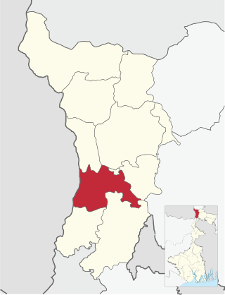
Matigara is a community development block that forms an administrative division in the Siliguri subdivision of the Darjeeling district in the Indian state of West Bengal.

<span class="mw-page-title-main">Kharibari (community development block)</span> Community development block in West Bengal, India

Kharibari is a community development block that forms an administrative division in the Siliguri subdivision of the Darjeeling district in the Indian state of West Bengal.

<span class="mw-page-title-main">Rangli Rangliot (community development block)</span> Community development block in West Bengal, India

Rangli Rangliot is a community development block that forms an administrative division in the Darjeeling Sadar subdivision of the Darjeeling district in the Indian state of West Bengal.

<span class="mw-page-title-main">Kalimpong I</span> Community development block in West Bengal, India

Kalimpong I is a community development block that forms an administrative division in the Kalimpong subdivision of the Kalimpong district in the Indian state of West Bengal.

<span class="mw-page-title-main">Gorubathan (community development block)</span> Community development block in West Bengal, India

Gorubathan is a community development block that forms an administrative division in the Kalimpong subdivision of the Kalimpong district in the Indian state of West Bengal.

<span class="mw-page-title-main">Kurseong (community development block)</span> Community development block in West Bengal, India

Kurseong is a community development block that forms an administrative division in the Kurseong subdivision of the Darjeeling district in the Indian state of West Bengal.

<span class="mw-page-title-main">Naxalbari (community development block)</span> Community development block in West Bengal, India

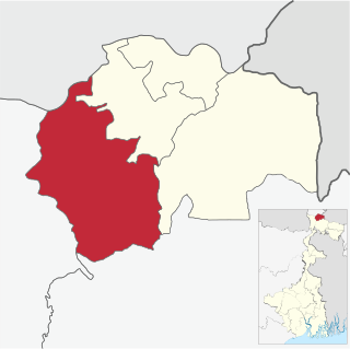
Naxalbari is a community development block that forms an administrative division in the Siliguri subdivision of the Darjeeling district in the Indian state of West Bengal.

Kharibari is a census town in the Kharibari CD block in the Siliguri subdivision of the Darjeeling district in the state of West Bengal, India.

Shyamdhan is a census town in the Kharibari CD block in the Siliguri subdivision of Darjeeling district in the state of West Bengal, India.

Tari is a census town in the Matigara CD block in the Siliguri subdivision of Darjeeling district in the state of West Bengal, India.

Jitu is a census town in the Matigara CD block in the Siliguri subdivision of Darjeeling district in the state of West Bengal, India.

Mathapari is a census town in the Matigara CD block in the Siliguri subdivision of Darjeeling district in the state of West Bengal, India.

Bara Mohansingh is a census town in the Matigara CD block in the Siliguri subdivision of Darjeeling district in the state of West Bengal, India.

Dumriguri is a census town in the Naxalbari CD block in the Siliguri subdivision of Darjeeling district in the state of West Bengal, India.

Geni is a census town in the Naxalbari CD block in the Siliguri subdivision of Darjeeling district in the state of West Bengal, India.

Bhimram is a census town in the Naxalbari CD block in the Siliguri subdivision of Darjeeling district in the state of West Bengal, India.

Lalman is a census town in the Naxalbari CD block in the Siliguri subdivision of Darjeeling district in the state of West Bengal, India.

References

  1. "District Census Handbook, Darjeeling, Series 20, Part XII A, 2011 Census of India" (PDF). Page 327: Phansidewa CD block. Directorate of Census Operations, West Bengal. Retrieved 22 February 2020.
  2. "District Census Handbook, Darjeeling, Series 20, Part XII A, 2011 Census of India" (PDF). Page 13: Physiography. Directorate of Census Operations, West Bengal. Retrieved 29 March 2020.
  3. "District Census Handbook, Darjeeling, Series 20, Part XII A, 2011 Census of India" (PDF). Pages 15-17: Drainage. Directorate of Census Operations, West Bengal. Retrieved 29 March 2020.
  4. "2011 Census – Primary Census Abstract Data Tables". West Bengal – District-wise. Registrar General and Census Commissioner, India. Retrieved 22 February 2020.
  5. "District Statistical Handbook 2013 Darjeeling". Tables 2.1, 2.2. Department of Statistics and Programme Implementation, Government of West Bengal. Archived from the original on 21 January 2019. Retrieved 22 February 2020.
  6. "District Profile - Darjeeling". District administration. Retrieved 22 February 2020.
  7. "District Census Handbook: Darjiling" (PDF). Map of District Darjiling with CD block HQs and Police Stations (on the fifth page). Directorate of Census Operations, West Bengal, 2011. Retrieved 22 February 2020.
  8. "55711/ Malda Town-New Jalpaiguri Passenger". Time Table. indiarailinfo. Retrieved 22 February 2020.
  9. "Phansidewa High School" . Retrieved 22 February 2020.
  10. "Phansidewa Govt. S.A. type H.S. for girls High School". ICBSE. Retrieved 22 February 2020.