Jalpaiguri Sadar subdivision

Last updated

Jalpaiguri Sadar subdivision
Subdivision
Jalpaiguri Sadar (subdivision) in Jalpaiguri (West Bengal).svg
Coordinates: 26°31′N88°44′E / 26.52°N 88.73°E / 26.52; 88.73
CountryFlag of India.svg  India
State West Bengal
District Jalpaiguri
Headquarters Jalpaiguri City
  RankUrban
Population
   Metro
1,925,632
Demonym(s) Jalpaigurians, Jalpaiguribashi
Languages
  Official Bengali, English
Time zone UTC+5:30 (IST)
ISO 3166 code ISO 3166-2:IN
Vehicle registration WB
Website wb.gov.in jalpaiguri.gov.in

Jalpaiguri Sadar subdivision is an administrative division of the Jalpaiguri district in the Indian state of West Bengal.

Contents

Geography

Subdivisions

Jalpaiguri district is divided into the following administrative subdivisions: [1] [2]

Jalpaiguri Subdivision Map (en).svg
SubdivisionHeadquarters
Area
km2
Population
(2011)
Rural
Population
% (2011)
Urban
Population
% (2011)
Jalpaiguri Sadar Jalpaiguri 2,245.471,811,88562.0137.99
Malbazar Malbazar 1,150.84569,71188.6811.32
Dhupguri Dhupguri ----
Total: Jalpaiguri district Jalpaiguri 3,396.312,381,59668.3931.61
Invisible Square.svg
Mapscaleline.svg
15km
10miles
Red pog.svg
B
A
N
G
L
A
D
E
S
H
B
H
U
T
A
N
Jaldhaka
River
River
Teesta
Chapramari
Wildlife
Sanctuary
NP
Invisible Square.svg
Gorumara
National
Park
NP
Invisible Square.svg
New Jalpaiguri JRS
F
Invisible Square.svg
Lakhipara TE
TE
Invisible Square.svg
Gandrapara TE
TE
Invisible Square.svg
Danguajhar TE
TE
Invisible Square.svg
Belakoba
R
Invisible Square.svg
Rajganj
R
Invisible Square.svg
Phulbari
checkpoint
R
Invisible Square.svg
Binnaguri 1
C
Invisible Square.svg
Dhupguri
M
Invisible Square.svg
Jalpaiguri
M
Invisible Square.svg
Telipara TG
CT
Invisible Square.svg
Banarhat
CT
Invisible Square.svg
Gairkata
CT
Invisible Square.svg
Dakshin Khagrabari
CT
Invisible Square.svg
Mainaguri
CT
Invisible Square.svg
Kharia
CT
Invisible Square.svg
Binnaguri 2
CT
Invisible Square.svg
Places and tea estates in Jalpaiguri Sadar subdivision (including Rajganj, Jalpaiguri and Maynaguri CD blocks) in Jalpaiguri district
CT: census town, R: rural/ urban centre, N: neighbourhood, C: cantonment, NP: national park/ wildlife sanctuary, TE: tea estate
Abbreviations used in names – TG for Tea Garden (town/village), TE for Tea Estate, JRS: junction railway station
Owing to space constraints in the small map, the actual locations in a larger map may vary slightly

Administrative units

Jalpaiguri Sadar subdivision has 4 police stations, 3 community development blocks, 3 panchayat samitis, 42 gram panchayats, 144 mouzas, 133 inhabited villages, 2 municipalities, part of 1 municipal corporation and 5 census towns. The municipalities are: Jalpaiguri and Mainaguri. The municipal corporation partly in the subdivision is Siliguri. The census towns are: Dabgram, Binnaguri, Chakiabhita, Kharia, and Dakshin Khagrabari. The subdivision has its headquarters at Jalpaiguri. [2] [3] [4]

Police stations

Police stations in the Jalpatguri Sadar subdivision have the following features and jurisdiction: [2] [5]

Police StationArea covered
km2
International border
Inter-state border
km
Municipal TownCD block
Rajganj n/an/a-- Rajganj (part)
Pradhan Nagar n/a-- Siliguri (part) Rajganj (part)
Jalpaiguri n/an/a- Jalpaiguri Jalpaiguri
Mainaguri n/a-- Mainaguri Maynaguri

Blocks

Community development blocks in the Jalpaiguri Sadar subdivision are: [2] [7] [8]

Jalpaiguri Tehsil Map (en).svg
CD blockHeadquartersArea
km2
Population
(2011)
SC  % ST  %Literacy
Rate %
Census
Towns
Rajganj Rajganj 614.82373,76649.564.1269.823
Jalpaiguri Jalpaiguri 500.65323,45560.786.0673.811
Maynaguri Mainaguri 530.60329,93271.201.3275.632

Gram Panchayats

The subdivision contains 42 gram panchayats under 3 community development blocks: [9] [10] [11]

Education

Given in the table below (data in numbers) is a comprehensive picture of the education scenario in Jalpaguri district, with data for the year 2013-14. [12]

SubdivisionPrimary
School
Middle
School
High
School
Higher Secondary
School
General
College, Univ
Technical /
Professional Instt
Non-formal
Education
InstitutionStudentInstitutionStudentInstitutionStudentInstitutionStudentInstitutionStudentInstitutionStudentInstitutionStudent
Jalpaiguri Sadar911115,080386,9125151,110116161,827819,4603413,0752,752189,077
Malbazar 29140,856284,9301314,5222737,14413,81012521,64378,471
Jalpaiguri district 1,202156,9366611,8426465,632143198,971913,2703513,3274,395267,448

Note: Primary schools include junior basic schools; middle schools, high schools and higher secondary schools include madrasahs; technical schools include junior technical schools, junior government polytechnics, industrial technical institutes, industrial training centres, nursing training institutes etc.; technical and professional colleges include engineering colleges, medical colleges, para-medical institutes, management colleges, teachers training and nursing training colleges, law colleges, art colleges, music colleges etc. Special and non-formal education centres include sishu siksha kendras, madhyamik siksha kendras, centres of Rabindra mukta vidyalaya, recognised Sanskrit tols, institutions for the blind and other handicapped persons, Anganwadi centres, reformatory schools etc. [12]

Educational institutions

The following institutions are located in Jalpaiguri Sadar subdivision:

Healthcare

The table below (all data in numbers) presents an overview of the medical facilities available and patients treated in the hospitals, health centres and sub-centres in Jalpaiguri district, with data for the year 2014.: [30]

SubdivisionHealth & Family Welfare Deptt, WB Other
State
Govt
Deptts
Local
bodies
Central
Govt
Deptts /
PSUs
NGO /
Private
Nursing
Homes
TotalTotal
Number
of
Beds
Total
Number
of
Doctors*
Indoor
Patients
Outdoor
Patients
Hospitals
Rural
Hospitals
Block
Primary
Health
Centres
Primary
Health
Centres
Jalpaiguri Sadar24-1821221501965269136,9011,435,220
Malbazar 1127---19305415033,971448,216
Jalpaiguri district 3522521240302,506319170,8721,883.436

.* Excluding nursing homes.

Medical facilities

Medical facilities in Jalpaiguri Sadar subdivision are as follows:

Hospitals: (Name, location, beds) [31]

Rural Hospitals: (Name, CD block, location, beds) [32]

Primary Health Centres : (CD block-wise)(CD block, PHC location, beds) [33]


Related Research Articles

Binnaguri is a cantonment town located in the Jalpaiguri district of West Bengal state, India. It is located at 26° 46' N latitude and 89° 3' E longitude at an altitude of 216 metres above sea level.

Banarhat is a census town of the Banarhat CD block in Dhupguri subdivision of the Jalpaiguri District in the state of West Bengal, India. Sharing nearest international border with BHUTAN.

<span class="mw-page-title-main">Dhupguri</span> City in West Bengal, India

Dhupguri is a town and a municipality of Jalpaiguri district near Jaldhaka River in the state of West Bengal, India.It is the headquarters of the Dhupguri subdivision.

Gairkata is a census town in the Dhupguri subdivision of the Jalpaiguri district in the state of West Bengal, India. It is the native town of prominent Bengali writer Samaresh Majumdar, poet and journalist Bikash Sarkar and CPI leader Samar Ganguly. Gairkata, home to Gosaihat Eco-Park, features Telipara as its main industrial hub. An NGO named Aaranyak was also located in Gairkata.

<span class="mw-page-title-main">Mainaguri</span> Town in West Bengal, India

Mainaguri is a Town and a Municipality in the Jalpaiguri Sadar subdivision of the Jalpaiguri district in the state of West Bengal, India. It is known as the "Gateway of the Dooars" and is a regionally significant tourist destination for Jalpesh Temple of Lord Shiva and nearby Gorumara National Park.

Dabgram is a census town in the Rajganj CD block in the Jalpaiguri Sadar subdivision of the Jalpaiguri district in the state of West Bengal, India.

<span class="mw-page-title-main">Malbazar subdivision</span> Subdivision in West Bengal, India

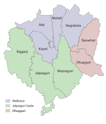
Malbazar subdivision is an administrative division of the Jalpaiguri district in the Indian state of West Bengal.

<span class="mw-page-title-main">Jalpaiguri (community development block)</span> Community development block in West Bengal, India

Jalpaiguri is a community development block that forms an administrative division in the Jalpaiguri Sadar subdivision of the Jalpaiguri district in the Indian state of West Bengal.

<span class="mw-page-title-main">Maynaguri (community development block)</span> Community development block in West Bengal, India

Maynaguri is a community development block that forms an administrative division in the Jalpaiguri Sadar subdivision of the Jalpaiguri district in the Indian state of West Bengal.

<span class="mw-page-title-main">Dhupguri (community development block)</span> Community development block in West Bengal, India

Dhupguri is a community development block that forms an administrative division in the Dhupguri subdivision of the Jalpaiguri district in the Indian state of West Bengal.

<span class="mw-page-title-main">Rajganj (community development block)</span> Community development block in West Bengal, India

Rajganj is a community development block that forms an administrative division in Jalpaiguri Sadar subdivision of Jalpaiguri district in the Indian state of West Bengal.

<span class="mw-page-title-main">Belakoba</span> Town in West Bengal, India

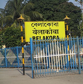
Belakoba is a small town in Jalpaiguri Sadar subdivision of Jalpaiguri district in the Indian state of West Bengal, known for its Chamcham, a type of sweet originating in the Pora Bari locale of Bangladesh. Belakoba is not only a cradle to Chamcham, but also cradle to art and music.

<span class="mw-page-title-main">Alipurduar subdivision</span> Subdivision in West Bengal, India

Alipurduar subdivision is an administrative division of the Alipurduar district in the Indian state of West Bengal.

Rajganj is a neighbourhood in the Rajganj CD block in the Jalpaiguri Sadar subdivision of the Jalpaiguri district in the state of West Bengal, India.

Binnaguri is a census town and a gram panchayat in the Rajganj CD block in the Jalpaiguri Sadar subdivision of the Jalpaiguri district in the state of West Bengal, India.

Kharia is a census town and a gram panchayat in the Jalpaiguri CD block in the Jalpaiguri Sadar subdivision of the Jalpaiguri district in the state of West Bengal, India.

Dakshin Khagrabari is a census town in the Maynaguri CD block in the Jalpaiguri Sadar subdivision of the Jalpaiguri district in the state of West Bengal, India.

Telipara Tea Garden is a census town in the Dhupguri CD block in the Jalpaiguri Sadar subdivision of the Jalpaiguri district in the state of West Bengal, India.

Gandrapara Tea Estate and Lakhipara Tea Estate are tea gardens, located near each other in the Dhupguri CD block in the Jalpaiguri Sadar subdivision of the Jalpaiguri district in the Indian state of West Bengal. Both the tea estates are located in the north-central portion of the Dooars.

<span class="mw-page-title-main">Banarhat (community development block)</span> Community development block in West Bengal, India

Banarhat is a community development block that forms an administrative division in the Dhupguri subdivision of the Jalpaiguri district in the India state of West Bengal.

References

  1. "Jalpaiguri". District Profile. District administration. Retrieved 29 June 2020.
  2. 1 2 3 4 "District Statistical Handbook 2014 Jalpaiguri". Tables 2.2, 2.4b. Department of Planning and Statistics, Government of West Bengal. Retrieved 29 June 2020.
  3. "Directory of District, Subdivision, Panchayat Samiti/ Block and Gram Panchayats in West Bengal". Jalpaiguri. Retrieved 29 June 2020.
  4. "Two new civic bodies for Jalpaiguri and Alipurduar districts".
  5. "Search a Police Station". Jalpaiguri Police. Retrieved 29 June 2020.
  6. "Gazette Notification for formation of Dhupguri Sub-Division, Dist Jalpaiguri" . Retrieved 22 February 2024.
  7. "CD block Wise Primary Census Abstract Data(PCA)". 2011 census: West Bengal – District-wise CD blocks. Registrar General and Census Commissioner, India. Retrieved 29 June 2020.
  8. "District Census Handbook, Jalpaiguri, Series 20, Part XIIA" (PDF). Census of India 2011, Fifth page, map of Jalpaiguri district. Directorate of Census Operations, West Bengal. Retrieved 29 June 2020.
  9. "Directory of District, Subdivision, Panchayat Samiti/ Block and Gram Panchayats in West Bengal". Bankura – Revised in March 2008. Panchayats and Rural Development Department, Government of West Bengal. Retrieved 29 June 2020.
  10. "Banarhat TMC Inner Clash: বছর ঘুরলেও ব্লক পঞ্চায়েত সমিতি গঠিত হয়নি! নেপথ্যে কি শাসকদলের গোষ্ঠীকোন্দল?". 8 December 2021.
  11. "Dhupguri Subdivision Now Official" . Retrieved 22 February 2024.
  12. 1 2 "District Statistical Handbook 2013 Jalpaiguri". Tables 4.4. Department of Statistics and Programme Implementation, Government of West Bengal. Retrieved 29 June 2020.
  13. "Ananda Chandra College". AC. Retrieved 29 June 2020.
  14. "Ananda Chandra College". College Dekho. Retrieved 29 June 2020.
  15. "Ananda Chandra College of Commerce". ACC. Retrieved 29 June 2020.
  16. "Banarhat Kartik Oraon Hindi Government College". BKOHGC. Retrieved 29 June 2020.
  17. "Dhupguri Girls' College". DGC. Retrieved 29 June 2020.
  18. "Jalpaiguri Government Engineering College". JGEC. Retrieved 29 June 2020.
  19. "Jalpaiguri Law College". JLC. Retrieved 29 June 2020.
  20. "Kabi Sukanta Mahavidyalaya". KSMV. Retrieved 29 June 2020.
  21. "Maynaguri College". MC. Retrieved 29 June 2020.
  22. "North Bengal St. Xavier's College". NBSXC. Retrieved 29 June 2020.
  23. "Prassana Deb Women's College". College Admission. Retrieved 29 June 2020.
  24. "Prasannadeb Women's College". College Admission. Retrieved 29 June 2020.
  25. "Rajganj College". RC. Retrieved 29 June 2020.
  26. "Jalpaiguri Polytechnic Institute". JPI. Retrieved 12 March 2024.
  27. "Maynaguri Government Polytechnic". MGP. Retrieved 12 March 2024.
  28. "Rajganj Government Polytechnic". RGP. Retrieved 12 March 2024.
  29. "Jalpaiguri Institute of Technology". JIT. Retrieved 12 March 2024.
  30. "District Statistical Handbook 2013 Darjeeling". Tables 3.1, 3.3. Department of Statistics and Programme Implementation, Government of West Bengal. Retrieved 26 February 2020.
  31. "Health & Family Welfare Department" (PDF). Health Statistics - Hospitals. Government of West Bengal. Retrieved 1 July 2020.
  32. "Health & Family Welfare Department" (PDF). Health Statistics – Rural Hospitals. Government of West Bengal. Retrieved 1 July 2020.
  33. "Health & Family Welfare Department" (PDF). Health Statistics – Primary Health Centres. Government of West Bengal. Retrieved 1 July 2020.