Bangor Township, Bay County, Michigan

Last updated

Bangor Township, Michigan
Charter Township of Bangor
Bangor Township, Bay City, Michigan.jpg
Township Hall and Administrative Offices
Bangor Charter Township (Bay), MI location.png
Location within Bay County
USA Michigan location map.svg
Red pog.svg
Bangor Township
Location within the state of Michigan
Coordinates: 43°38′08″N83°54′20″W / 43.63556°N 83.90556°W / 43.63556; -83.90556
Country United States
State Michigan
County Bay
Established1859
Government
  SupervisorGlenn Rowley
   Clerk Dawn Bublitz
Area
  Total21.9 sq mi (56.7 km2)
  Land13.9 sq mi (36.0 km2)
  Water8.0 sq mi (20.8 km2)
Elevation
584 ft (178 m)
Population
 (2010)
  Total14,641
  Density1,119.4/sq mi (432.2/km2)
Time zone UTC-5 (Eastern (EST))
  Summer (DST) UTC-4 (EDT)
ZIP code(s)
48706 (Bay City)
Area code 989
FIPS code 26-05120 [1]
GNIS feature ID1625878 [2]
Website Official website

Bangor Charter Township is a charter township in Bay County in the U.S. state of Michigan. The township's population was 14,045 [3] as of the 2020 Census and is included in the Bay City Metropolitan Statistical Area.

Contents

Communities

The township contains five unincorporated communities:

History

Joseph Trombley in 1834 purchased Bangor township's section 16 from the government which was the beginning of the Bangor settlement. [10] Bangor was platted in 1851 and was renamed Banks in 1864. In 1871, Banks became an incorporated village while Wenona was platted. [11] In 1873, the Township consisted of about 10 sections. The community of Bangor in 1873 was served by the Banks Post Office [12] which opened on May 18, 1864. The Banks Post Office was closed on May 1, 1866. On Nov 17, 1870, the Banks Post Office was reopened. [13] By 1873, Wenona was served by a post office with the same name. [12] The City of West Bay City, also known as West Bank City, was formed in 1877 by the state legislature consolidating the communities of Banks, Salzburg, and Wenona. [14] [15]

Bay Side was a coal mining village in Bangor Township established in 1899. [16] 

Geography

According to the United States Census Bureau, the township has a total area of 21.9 square miles (57 km2), of which 13.9 square miles (36 km2) is land and 8.0 square miles (21 km2) (36.58%) is water.

Demographics

Historical population
CensusPop.Note
1990 16,028
2000 15,547−3.0%
2010 14,641−5.8%

As of the census [1] of 2000, there were 15,547 people, 6,285 households, and 4,386 families residing in the township. The population density was 1,119.4 inhabitants per square mile (432.2/km2). There were 6,563 housing units at an average density of 472.6 per square mile (182.5/km2). The racial makeup of the township was 96.48% White, 0.62% African American, 0.44% Native American, 0.57% Asian, 0.02% Pacific Islander, 0.68% from other races, and 1.19% from two or more races. Hispanic or Latino of any race were 2.66% of the population.

There were 6,285 households, out of which 30.4% had children under the age of 18 living with them, 55.1% were married couples living together, 10.9% had a female householder with no husband present, and 30.2% were non-families. 26.1% of all households were made up of individuals, and 11.1% had someone living alone who was 65 years of age or older. The average household size was 2.44 and the average family size was 2.94.

In the township the population was spread out, with 23.7% under the age of 18, 7.7% from 18 to 24, 26.8% from 25 to 44, 27.1% from 45 to 64, and 14.7% who were 65 years of age or older. The median age was 40 years. For every 100 females, there were 93.0 males. For every 100 females age 18 and over, there were 89.5 males.

The median income for a household in the township was $42,358, and the median income for a family was $52,574. Males had a median income of $40,876 versus $24,776 for females. The per capita income for the township was $21,723. About 4.7% of families and 7.2% of the population were below the poverty line, including 7.8% of those under age 18 and 7.2% of those age 65 or over.

Education

Bangor Township Schools operates area public schools, including John Glenn High School.

Related Research Articles

<span class="mw-page-title-main">Au Train Township, Michigan</span> Civil township in Michigan, United States

Au Train Township is a civil township of Alger County in the U.S. state of Michigan. As of the 2020 census, its population was 1,019.

<span class="mw-page-title-main">Munising Township, Michigan</span> Civil township in Michigan, United States

Munising Township is a civil township of Alger County in the U.S. state of Michigan. As of 2020, its population was 2,865.

Casco Township is a civil township of Allegan County in the U.S. state of Michigan. The population was 2,823 at the 2010 census.

<span class="mw-page-title-main">Beaver Township, Bay County, Michigan</span> Civil township in Michigan, United States

Beaver Township is a civil township of Bay County in the U.S. state of Michigan. The township's population was 2,885 as of the 2010 census. It is included in the Bay City Metropolitan Statistical Area.

<span class="mw-page-title-main">Fraser Township, Michigan</span> Civil township in Michigan, United States

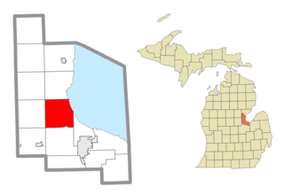
Fraser Township is a civil township of Bay County in the U.S. state of Michigan. The township's population was 3,192 as of the 2010 census. It is included in the Bay City Metropolitan Statistical Area.

<span class="mw-page-title-main">Kawkawlin Township, Michigan</span> Civil township in Michigan, United States

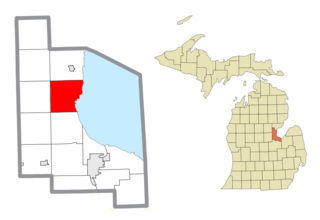
Kawkawlin Township is a civil township of Bay County in the U.S. state of Michigan. The township's population was 4,848 as of the 2010 census. It is included in the Bay City Metropolitan Statistical Area.

<span class="mw-page-title-main">Merritt Township, Michigan</span> Civil township in Michigan, United States

Merritt Township is a civil township of Bay County in the U.S. state of Michigan. The township's population was 1,441 as of the 2010 census. It is included in the Bay City Metropolitan Statistical Area.

<span class="mw-page-title-main">Mount Forest Township, Michigan</span> Civil township in Michigan, United States

Mount Forest Township is a civil township of Bay County in the U.S. state of Michigan. The township's population was 1,392 as of the 2010 census. It is included in the Bay City Metropolitan Statistical Area.

<span class="mw-page-title-main">Winsor Township, Michigan</span> Civil township in Michigan, United States

Winsor Township is a civil township of Huron County in the U.S. state of Michigan. The population was 2,044 at the 2000 census.

<span class="mw-page-title-main">Chesterfield Township, Michigan</span> Charter township in Michigan, United States

Chesterfield Charter Township is a charter township of Macomb County in the U.S. state of Michigan. As of the 2020 census the population was 45,376.

<span class="mw-page-title-main">Shelby Charter Township, Michigan</span> Charter township in Michigan, United States

Shelby Charter Township, officially the Charter Township of Shelby, is a charter township located in Macomb County in the U.S. state of Michigan. The township is an affluent northern suburb of Detroit. As of the 2020 census, the population was 79,408, up from 73,804 in 2010. Shelby Charter Township is one of the fastest-growing communities in Metro Detroit.

<span class="mw-page-title-main">Commerce Township, Michigan</span> Charter township in Michigan, United States

Commerce Township, officially the Charter Township of Commerce, is a charter township of Oakland County in the U.S. state of Michigan. The population was 40,186 at the 2010 census.

<span class="mw-page-title-main">Groveland Township, Michigan</span> Civil township in Michigan, United States

Groveland Township is a civil township of Oakland County in the U.S. state of Michigan. The population was 5,476 at the 2010 census. Groveland Township was established in 1835.

<span class="mw-page-title-main">Highland Township, Oakland County, Michigan</span> Charter township in Michigan, United States

Highland Township, officially the Charter Township of Highland, is a charter township of west Oakland County, Michigan. The population was 19,202 at the time of the 2010 census.

Austin Township is a civil township of Sanilac County of the U.S. state of Michigan. As of the 2020 census, the township had a total population 619. The township was organized in 1851.

<span class="mw-page-title-main">Cottrellville Township, Michigan</span> Civil township in Michigan, United States

Cottrellville Township is a civil township of St. Clair County in the U.S. state of Michigan. The population was 3,559 at the 2010 Census.

<span class="mw-page-title-main">Wales Township, Michigan</span> Civil township in Michigan, United States

Wales Township is a civil township of St. Clair County in the U.S. state of Michigan. The population was 3,248 at the 2010 Census.

<span class="mw-page-title-main">Ira Township, Michigan</span> Civil township in Michigan, United States

Ira Township is a civil township of St. Clair County in the U.S. state of Michigan. The population was 5,178 at the 2010 Census.

<span class="mw-page-title-main">Linwood, Michigan</span> Unincorporated community in Michigan, United States

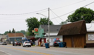
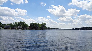
Linwood is a small unincorporated community in the northern portion of Bay County in the U.S. state of Michigan. The community is on the boundary between Fraser Township on the north and Kawkawlin Township on the south. It is situated with M-13 to the west and the Saginaw Bay of Lake Huron on the east, between Kaiser Tower Road and Elevator Road where Linwood Road becomes Center Street. Bay City is about 12 miles to the south and Linwood is included in the Bay City Metropolitan Statistical Area.

West Bay City was a city in Bay County the U.S. state of Michigan. The city was formed from the communities of Banks, Salzburg, and Wenona. The city existed from 1877 to 1905 when it was merged with Bay City, Michigan.

References

Notes

  1. 1 2 "U.S. Census website". United States Census Bureau . Retrieved 2008-01-31.
  2. "Bangor Township, Bay County, Michigan". Geographic Names Information System . United States Geological Survey, United States Department of the Interior.
  3. "U.S. Census Bureau QuickFacts: Bangor charter township, Bay County, Michigan; Bay County, Michigan". www.census.gov. Retrieved 2024-01-17.
  4. "Aplin Beach, Michigan". Geographic Names Information System . United States Geological Survey, United States Department of the Interior. & GNIS in Google Map
  5. "Donahue Beach, Michigan". Geographic Names Information System . United States Geological Survey, United States Department of the Interior. & GNIS in Google Map.
  6. "Killarney Beach, Michigan". Geographic Names Information System . United States Geological Survey, United States Department of the Interior.. & GNIS in Google Map.
  7. "Lagoon Beach, Michigan". Geographic Names Information System . United States Geological Survey, United States Department of the Interior. & GNIS in Google Map.
  8. "Little Killarney Beach, Michigan". Geographic Names Information System . United States Geological Survey, United States Department of the Interior. & GNIS in Google Map.
  9. "Tobico Beach, Michigan". Geographic Names Information System . United States Geological Survey, United States Department of the Interior. & GNIS in Google Map.
  10. History of the Village of Bangor as it Appeared in the First Directory Archived 2014-03-23 at the Wayback Machine . Looking Backward. September 11, 1903. Bay City Tribune.
  11. Station: Bay City Menu Archived 2013-04-12 at the Wayback Machine . Michigan's Internet Railroad History Museum. Retrieved July 25, 2013.
  12. 1 2 File:Bay_County.jpg
  13. U.S. Geological Survey Geographic Names Information System: Banks Post Office (historical)
    Citation: Ellis, David M. Michigan Postal History, The Post Offices 1805-1986. 12-Dec-1993.
  14. U.S. Geological Survey Geographic Names Information System: West Bay City, Michigan
  15. Romig 1986.
  16. Romig 1986, p. 48.

Sources