Bannerdale Crags

Last updated

Bannerdale Crags
Bannerdale Crags.JPG
Bannerdale Crags from Mungrisdale
Highest point
Elevation 683 m (2,241 ft)
Prominence c. 37 m (120 ft)
Parent peak Bowscale Fell
Listing Wainwright, Hewitt, Nuttal
Coordinates 54°39′06″N3°01′56″W / 54.65169°N 3.03217°W / 54.65169; -3.03217
Geography
Lake District National Park UK relief location map.png
Red triangle with thick white border.svg
Bannerdale Crags
Location in Lake District, UK
Location Cumbria, England
Parent range Lake District, Northern Fells
OS grid NY335290
Topo map OS Landranger 89, 90 OS Explorer OL5

Bannerdale Crags is a fell in the English Lake District. It stands between Blencathra and Bowscale Fell in the Northern Fells.

Contents

Topography

Bannerdale Crags is a ridge running north west to south east. The name was originally applied purely to the steep north eastern flank, but is now generally given to the fell as a whole. [1]

A broad convex slope descends northward from Blencathra's Atkinson Pike top, gradually resolving into two ridges. The western arm continues to Mungrisdale Common while the north eastern limb, flecked with outcropping rock, falls to a steep sided col at 2,020 ft (620 m). From the depression Blackhazel Beck descends north west to join the River Caldew while the source of the Glenderamackin lies on the opposite slope. Across the col smooth slopes rise once more up the south western flank of the Bannerdale Crags ridge. There is little clue here to the wall of crags on the other side.

The north eastern side of the ridge looks down upon the valley of Bannerdale Beck, a tributary of the Glenderamackin. The crags on this side are almost continuous for a mile in length, the highest sections falling 600 ft (180 m) to the valley. The major breach is a spur protruding from the face almost below the summit, providing a fine route of ascent.(see below)

To the north the summit ridge continues across a broad grassy saddle to Bowscale Fell, the crags continuing a little way into the territory of the neighbouring fell. By contrast to the south east the fell ends in White Horse Bent, the abrupt ridge-end descent to the Glenderamackin. This river has one of the most convoluted passages in the district, passing around the south and east of Bannerdale Crags, before turning back on itself to surround Souther Fell on almost all sides and finally head west for Keswick and the River Derwent.

sketch map of Bannerdale Crags Bannerdale Crags sketch map.JPG
sketch map of Bannerdale Crags

Summit

The summit of the fell is smooth and grassy, the highest point being set back from the crags and marked by a small cairn of flat stones. Nearer the face is another cairn, referred to on older large scale maps as a currick – a stone shelter built by shepherds. [1] [2] The view is surprisingly extensive, the Coniston Fells being in sight to the south, 20 miles (30 km) away. The Eastern and Far Eastern Fells are also in view, but the highlight is probably Sharp Edge and the eastern prospect of Blencathra. [1] [2]

Geology

In common with much of the Northern Fells the Kirk Stile Formation of the Skiddaw Group predominates. This is composed of laminated mudstone and siltstone with greywacke sandstone and is of Ordovician age. [3]

Bannerdale lead mine was operated at the base of the crag itself, primarily in the latter half of the nineteenth century. This raised galena and blende from an east- west vein system with two major levels being over 100 ft long. Further workings below the summit were known as the graphite level. It is not known how much was found, but the level has only been driven a few feet. [4]

Saddleback Old Mine lies to the south of the fell, near to the col connecting it with Blencathra. This was also driven for lead, but the vein proved to consist mainly of limonite. An attempt was made to market this as a pigment, but commercial success was elusive and there are no records of operation after 1894. [4]

Ascents

Starting from Mungrisdale village to the east the Glenderamackin can be followed as far as its confluence with Bannerdale Beck. From here the east spur climbs almost direct to the summit, the rock scenery improving throughout and ending with a gentle scramble. An alternative from Mungrisdale is the wide and easy track leading up to the ridge between Bannerdale Crags and Bowscale Fell.

Less direct is the climb from Scales, first crossing Mousthwaite Combe to reach the Glenderamackin to the south of the fell. From here a straightforward assault on White Horse Bent is one alternative, or the miners track can be followed to Saddleback Old Mine and the source of the river. [1]

Related Research Articles

<span class="mw-page-title-main">Blencathra</span> Hill in the Lake District, England

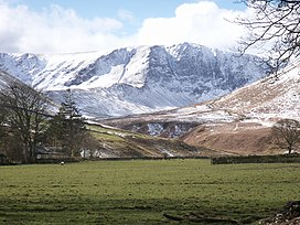
Blencathra, also known as Saddleback, is one of the most northerly hills in the English Lake District. It has six separate fell tops, of which the highest is the Hallsfell Top at 2,848 feet.

<span class="mw-page-title-main">Great Dodd</span> Mountain in the English Lake District, Cumbria, England

Great Dodd is a mountain or fell in the English Lake District. It stands on the main ridge of the Helvellyn range, a line of mountains which runs in a north-south direction between the lakes of Thirlmere and Ullswater in the east of the Lake District. Great Dodd, with a height of 857 metres (2,812 ft) is the highest of the fells in this range to the north of Sticks Pass.

<span class="mw-page-title-main">Hallin Fell</span>

Hallin Fell is a hill in the English Lake District surrounded on three sides by Ullswater.

<span class="mw-page-title-main">Dollywaggon Pike</span> Mountain in the English Lake District, Cumbria, England

Dollywaggon Pike is a fell in the English Lake District. It stands on the main spine of the Helvellyn range in the Eastern Fells, between Thirlmere and the Ullswater catchment.

<span class="mw-page-title-main">Stybarrow Dodd</span> Fell in the Lake District, Cumbria, England

Stybarrow Dodd is a mountain or fell in the English Lake District. It stands immediately north of Sticks Pass on the main ridge of the Helvellyn range in the Eastern Fells, which is situated between the lakes of Thirlmere and the Ullswater.

<span class="mw-page-title-main">Clough Head</span> Mountain in the English Lake District, Cumbria, England

Clough Head is a fell, or hill, in the English Lake District. It marks the northern end of the main ridge of the Helvellyn range and is often walked as part of the ridge walk. The fell stands south of the village of Threlkeld and the A66 road, and it forms the steep eastern side of the tranquil valley of St John's in the Vale.

<span class="mw-page-title-main">Knott, Caldbeck</span> Mountain in the Lake District, England

Knott is a mountain in the northern part of the English Lake District. It is the highest point of the Back o'Skiddaw region, an area of wild and unfrequented moorland to the north of Skiddaw and Blencathra. Other tops in this region include High Pike, Carrock Fell and Great Calva. The fell's slopes are mostly smooth, gentle, and covered in grass, with a few deep ravines. It stands a long way from a road and requires a long walk across the moor top get to it; this, as well as the fact that it is hidden from the rest of the Lake District by the two aforementioned giants, make it one of the most unfrequented tops in the Lakes. When it is climbed it is most often from Mungrisdale or from the north via Great Sca Fell. The word Knott is of Cumbric origin, and means simply "hill".

<span class="mw-page-title-main">Great Mell Fell</span>

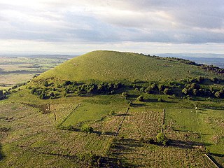
Great Mell Fell is an isolated hill or fell in the English Lake District, north of Ullswater and adjacent to the Eastern Fells. It rises from a level plain to a height of 537 m. Its top is an excellent viewpoint for many of the surrounding higher fells. The fell is now owned and managed by the National Trust and offers a place of quiet refuge.

<span class="mw-page-title-main">Carl Side</span> Mountain in the Lake District, England

Carl Side is a fell in the English Lake District, forming a part of the Skiddaw "family" near the town of Keswick and prominently visible from its streets. It is listed in Alfred Wainwright's Pictorial Guides to the Lakeland Fells as one of the Northern Fells.

<span class="mw-page-title-main">Mungrisdale Common</span> Mountain in the Lake District, England

Mungrisdale Common, pronounced mun-grize-dl, with emphasis on grize, is a fell in the English Lake District. Although Alfred Wainwright listed it as one of the 214 featured hills in his influential Pictorial Guide to the Lakeland Fells it was his least favourite. He commented that it "has no more pretension to elegance than a pudding that has been sat on". There is some speculation that Wainwright included the fell in his guide simply as a way to fill space, but that has never been proven. Mungrisdale Common is oddly named, as it is a number of miles from the village of Mungrisdale, which lies in a different river catchment.

<span class="mw-page-title-main">Latrigg</span> Mountain in United Kingdom

Latrigg is one of the lowest fells in the Lake District in North West England, but is a popular climb due to its convenient location overlooking the town of Keswick and the beautiful views down the valley of Borrowdale from the summit. It is the least mountainous of the Skiddaw fells, the summit being almost entirely devoid of rock. The slopes of Latrigg are partially wooded, and logging work is currently being undertaken. One lone tree just south of the summit is prominently viewed in silhouette when approaching Keswick from the west along the A66. It also has petrified trees on top.

<span class="mw-page-title-main">Red Pike (Wasdale)</span> Mountain in the English Lake District, Cumbria, England

Red Pike is a fell in the English Lake District. It is 826 m or 2,709 ft high and lies due north of Wast Water. It is often climbed as part of the Mosedale Horseshoe, a walk which also includes Pillar.

<span class="mw-page-title-main">Watson's Dodd</span>

Watson's Dodd is a fell in the English Lake District, a minor rise on the main ridge of the Helvellyn range in the Eastern Fells, but a prominent shoulder on the west side of that range.

<span class="mw-page-title-main">Hart Side</span>

Hart Side is a subsidiary top on one of the east ridges of Stybarrow Dodd, which is a mountain in the English Lake District, west of Ullswater on the main Helvellyn ridge in the Eastern Fells. With a height of 2,480 feet (760 m) Hart Side rises above the col separating it from Green Side by 75 feet (23 m).

<span class="mw-page-title-main">Sheffield Pike</span>

Sheffield Pike is a fell in the English Lake District, a prominent intermediate top on one of the eastern ridges of Stybarrow Dodd. It separates and stands high above the Glencoyne and Glenridding valleys, on the eastern side of the Helvellyn range in the Eastern Fells and it looks down onto Ullswater.

<span class="mw-page-title-main">Mungrisdale</span> Village and parish in England

Mungrisdale is a small village and civil parish in the north east of the English Lake District in Cumbria. It is also the name of the valley in which the village sits. Mungrisdale is a popular starting point for ascents of the nearby hills, such as Bowscale Fell, Bannerdale Crags and Souther Fell. It lies on the River Glenderamackin, a tributary of the Greta.

<span class="mw-page-title-main">Bowscale Fell</span> Mountain in the Lake District, England

Bowscale Fell is a hill in the English Lake District. It rises above the village of Mungrisdale in the Northern Fells. Bowscale Fell stands at the extreme north east the Blencathra group, connected to this higher fell by the intervening Bannerdale Crags. In common with many fells the western slopes are smooth and convex while the eastern side exhibits crags.

<span class="mw-page-title-main">Lonscale Fell</span> Mountain in the Lake District, England

Lonscale Fell is a hill in the English Lake District. Its pointed second top is instantly recognisable, standing at the eastern end of the Skiddaw massif. The fell is easily climbed from Keswick or from Skiddaw House to the north. Although now primarily a sheep pasture, it once saw considerable mining activity beneath the long eastern wall of crag.

<span class="mw-page-title-main">Souther Fell</span> Mountain in the Lake District, England

Souther Fell is a fell in the English Lake District. It stands to the south of Mungrisdale village in the Northern Fells. It is most famous for the appearance of a "spectral army", said to have been seen marching along its crest on Midsummer's Day, 1745. No such force was in the District at the time.

<span class="mw-page-title-main">Northern Fells</span>

The Northern Fells are a part of the Cumbrian Mountains in the Lake District of England. Including Skiddaw, they occupy a wide area to the north of Keswick. Smooth, sweeping slopes predominate, with a minimum of tarns or crags. Blencathra in the south-east of the group is the principal exception to this trend.

References

  1. 1 2 3 4 Wainwright, Alfred: A Pictorial Guide to the Lakeland Fells,Book 5 The Northern Fells: ISBN   0-7112-2458-7
  2. 1 2 Birkett, Bill: Complete Lakeland Fells: Harper Collins (1994): ISBN   0-00-218406-0
  3. British Geological Survey: 1:50,000 series maps, England & Wales Sheet 29: BGS (1999)
  4. 1 2 Adams, John: Mines of the Lake District Fells: Dalesman (1995) ISBN   0-85206-931-6