Souther Fell

Last updated

Souther Fell
Souther Fell from Scales Fell, Blencathra.jpg
Seen across Mousethwaite Col from Scales Fell on Blencathra.
Highest point
Elevation 522 m (1,713 ft)
Prominence c. 87 m
Parent peak Blencathra
Listing Wainwright
Coordinates 54°39′14″N3°00′04″W / 54.65375°N 3.00122°W / 54.65375; -3.00122
Geography
Lake District National Park UK relief location map.png
Red triangle with thick white border.svg
Souther Fell
Location in Lake District, UK
Location Cumbria, England
Parent range Lake District, Northern Fells
OS grid NY355292
Topo map OS Landranger 89, 90 OS Explorer OL5
Seen from the village of Mungrisdale. Souther Fell from Mungrisedale 1.jpg
Seen from the village of Mungrisdale.
Map of Souther Fell Souther Fell sketch map.JPG
Map of Souther Fell
The view west from the summit takes in Blencathra and Bannerdale Crags. Blencathra and Bannerdale Crags from Souther Fell 2.jpg
The view west from the summit takes in Blencathra and Bannerdale Crags.

Souther Fell is a fell in the English Lake District. It stands to the south of Mungrisdale village in the Northern Fells. It is most famous for the appearance of a "spectral army", said to have been seen marching along its crest on Midsummer's Day, 1745. No such force was in the District at the time.

Contents

Topography

Souther Fell is the eastern extremity of Blencathra, a continuation of the arm that runs down from the summit over Doddick Fell and Scales Fell. A smooth slope falls eastward from Scales Fell to the col of Mousthwaite Comb at 1,425 feet (434 m). The ridge then turns northeast for two miles along the summit of Souther Fell.

Mousthwaite Comb is a geographical oddity. To the north of the depression, running eastward, is the River Glenderamackin. To the south of the col, flowing westward, is the same river. In the intervening time the Glenderamackin has run for six miles, surrounding Souther Fell on three sides like a moat. The Comb provides its only dryshod connection to other ground and even this is almost cut off by the tributary of Comb Beck on the southern slope.

The far northern end of the ridge falls quite steeply to a bend of the Glenderamackin, across which is the village of Mungrisdale. The eastern flanks are quite smooth and towards the south have been enclosed to provide pasture land. Southernfell, Far Southernfell and Hazelhurst are the farms here. At the southern end, on the turn of the ridge, is the rockier slope of Knotts, falling toward the main Keswick to Penrith road.

The western side of the fell stands above the enclosed valley of the upper Glenderamackin, looking across to Bannerdale Crags. Souther Fell has two principal tops and each stands above a patch of scree and rock on this face. A footbridge crosses the river just north of Mousthwaite Comb, the only reliable crossing between here and Mungrisdale village.

Geology

In common with much of the Northern Fells, the Kirk Stile Formation of the Skiddaw Group predominates. This is composed of laminated mudstone and siltstone with greywacke sandstone and is of Ordovician age. [1]

The "Spectral Army" of Souther Fell

On the evening of Midsummer's Day 1745, a line of marching troops, cavalry and even carriages was seen travelling along the summit ridge of Souther Fell. The ground over which they appeared to move was known to be too steep for such transport, but the procession continued unabated for some hours until night fell, constantly appearing at one end of the ridge and disappearing at the other. 26 sober and respected witnesses were assembled to view the proceedings and later testified on oath to what they had seen. The next day Souther Fell was climbed and not a footprint was found on the soft ground of the ridge. One scientific explanation offered was that this was some bizarre mirage or reflection of the army of Bonnie Prince Charlie, that day exercising on the Scottish coast, [2] while another explanation suggests that the sighting was originally misidentifying the smoke from Germanic bonfire rituals, with the story of the "Spectral Army" evolving over the years through transmission and adaptation in the popular press. [3]

Summit

Souther Fell has two main tops, although a number of other bumps crown the ridge. That to the northeast is the true summit, the southern top being perhaps 30 ft lower. A small cairn marks the top.

This being the last of the Northern Fells in that direction, the view across to the Pennines is uninterrupted. The Lakeland view peeps around the looming presence of Blencathra, taking in Great Gable, the Scafells, the nearer Helvellyn range and a portion of the Far Eastern Fells. [2]

Ascents

From Scales on the A66 road an ascent can be made up Comb Gill to Mousthwaite Comb. From Mungrisdale Wainwright propounds a direct route across the fields behind the Mill Inn. [2] Birkett, however, notes that this is no public right of way and suggests a diversion to the south. [4]

Related Research Articles

<span class="mw-page-title-main">Blencathra</span> Hill in the Lake District, England

Blencathra, also known as Saddleback, is one of the most northerly hills in the English Lake District. It has six separate fell tops, of which the highest is the Hallsfell Top at 2,848 feet.

<span class="mw-page-title-main">Causey Pike</span> Mountain in the English Lake District, Cumbria, England

Causey Pike is a fell in the English Lake District. It is situated in the Newlands Valley, 5 kilometres south-west of the town of Keswick. Even though it has a modest height of 637 metres (2,090 ft) it is one of the most distinctive fells when viewed from the Derwent Water and Keswick area due to its distinguishing summit "knobble" which catches the eye. The fell is one of 214 fells described by Alfred Wainwright in his series of Pictorial Guides to the Lakeland Fells: Causey Pike features in Book Six, The North Western Fells.

<span class="mw-page-title-main">Knott, Caldbeck</span> Mountain in the Lake District, England

Knott is a mountain in the northern part of the English Lake District. It is the highest point of the Back o'Skiddaw region, an area of wild and unfrequented moorland to the north of Skiddaw and Blencathra. Other tops in this region include High Pike, Carrock Fell and Great Calva. The fell's slopes are mostly smooth, gentle, and covered in grass, with a few deep ravines. It stands a long way from a road and requires a long walk across the moor top get to it; this, as well as the fact that it is hidden from the rest of the Lake District by the two aforementioned giants, make it one of the most unfrequented tops in the Lakes. When it is climbed it is most often from Mungrisdale or from the north via Great Sca Fell. The word Knott is of Cumbric origin, and means simply "hill".

High Rigg is a small fell located in the English Lake District, approximately three miles southeast of the town of Keswick. It occupies an unusual position, surrounded on all sides by higher fells but not connected by any obvious ridge. This separation from its fellows ensures that it is a Marilyn.

<span class="mw-page-title-main">Mellbreak</span>

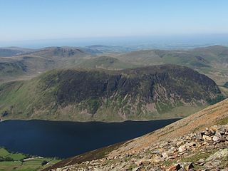
Mellbreak is a hill in the Western part of the English Lake District. Despite being surrounded on all sides by higher fells, it stands in isolation. It is surrounded on three sides by a "moat" of deep marshy land, and on the east side by the lake of Crummock Water. The fell forms a partnership with the lake, running parallel to it, falling sheer into it, and regularly providing the backdrop for pictures of it.

<span class="mw-page-title-main">Mungrisdale Common</span> Mountain in the Lake District, England

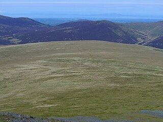
Mungrisdale Common, pronounced mun-grize-dl, with emphasis on grize, is a fell in the English Lake District. Although Alfred Wainwright listed it as one of the 214 featured hills in his influential Pictorial Guide to the Lakeland Fells it was his least favourite. He commented that it "has no more pretension to elegance than a pudding that has been sat on". There is some speculation that Wainwright included the fell in his guide simply as a way to fill space, but that has never been proven. Mungrisdale Common is oddly named, as it is a number of miles from the village of Mungrisdale, which lies in a different river catchment.

<span class="mw-page-title-main">Latrigg</span> Mountain in United Kingdom

Latrigg is one of the lowest fells in the Lake District in North West England, but is a popular climb due to its convenient location overlooking the town of Keswick and the beautiful views down the valley of Borrowdale from the summit. It is the least mountainous of the Skiddaw fells, the summit being almost entirely devoid of rock. The slopes of Latrigg are partially wooded, and logging work is currently being undertaken. One lone tree just south of the summit is prominently viewed in silhouette when approaching Keswick from the west along the A66. It also has petrified trees on top.

<span class="mw-page-title-main">Red Pike (Buttermere)</span> Mountain in the English Lake District, Cumbria, England

Red Pike is a fell in the High Stile range in the western English Lake District, which separates Ennerdale from the valley of Buttermere and Crummock Water. It is 2,476 ft (755 m) high. The direct ascent of Red Pike from Buttermere is very popular and the ridge walk from Red Pike to Haystacks is regarded as one of the finest in the area, with excellent views of the Scafells, Great Gable and Pillar.

<span class="mw-page-title-main">High Crag</span>

High Crag stands at the southern end of the High Stile ridge which divides the valleys of Ennerdale and Buttermere in the west of the English Lake District. It is often climbed as part of a popular ridge walk, from Black Sail youth hostel, or from Buttermere via Scarth Gap. Panoramas of the Great Gable and the Scafells are visible.

Selside Pike or Selside is a fell in the English Lake District. It stands between the valleys of Mardale and Swindale in the Far Eastern Fells.

<span class="mw-page-title-main">Fellbarrow</span>

Fellbarrow is a low hill in the north west of the English Lake District. It is not far from the town of Cockermouth, near to Loweswater and can most easily be climbed from Low Lorton or Thackthwaite. From the summit there are views across the Lorton valley to Grasmoor and Whiteside.

<span class="mw-page-title-main">Great Calva</span> Mountain in the Lake District, England

Great Calva is a fell in the Lake District, England. It is in the Northern Fells, lying roughly at the centre of this region of high ground. As a result, it is distant from roads and quite remote by Lakeland standards. Great Calva stands at the head of a major geological fault running through the centre of the Lake District, and so from the summit it is possible to see all the way south over Thirlmere. The subsidiary summit of Little Calva lies to the west.

<span class="mw-page-title-main">Graystones</span>

Graystones is a fell in the English Lake District. It lies in the North Western Fells region and is one of the peaks on the ridge which encircles the valley of Aiken Beck.

<span class="mw-page-title-main">Lank Rigg</span> Fell in the Lake District, England

Lank Rigg is a fell in the English Lake District. It stands to the south of Ennerdale in the Western Fells. A sprawling hill with gentle grassy slopes it can be climbed from various points on the Coldfell road. It carries various remains from ancient habitation.

<span class="mw-page-title-main">Lord's Seat</span> Hill in United Kingdom

Lord's Seat is a fell in the English Lake District. It is the highest of the group of hills north of Whinlatter Pass in the North Western Fells. The slopes of Lord's Seat are extensively forested.

<span class="mw-page-title-main">Bannerdale Crags</span> Mountain in the Lake District, England

Bannerdale Crags is a fell in the English Lake District. It stands between Blencathra and Bowscale Fell in the Northern Fells.

<span class="mw-page-title-main">Bowscale Fell</span> Mountain in the Lake District, England

Bowscale Fell is a hill in the English Lake District. It rises above the village of Mungrisdale in the Northern Fells. Bowscale Fell stands at the extreme north east the Blencathra group, connected to this higher fell by the intervening Bannerdale Crags. In common with many fells the western slopes are smooth and convex while the eastern side exhibits crags.

<span class="mw-page-title-main">Eastern Fells</span>

The Eastern Fells are a part of the Cumbrian Mountains in the Lake District of England. Centred on Helvellyn they primarily comprise a north–south ridge running between Ullswater and Lakeland's Central Valley.

<span class="mw-page-title-main">Southern Fells</span>

<span class="mw-page-title-main">Northern Fells</span>

The Northern Fells are a part of the Cumbrian Mountains in the Lake District of England. Including Skiddaw, they occupy a wide area to the north of Keswick. Smooth, sweeping slopes predominate, with a minimum of tarns or crags. Blencathra in the south-east of the group is the principal exception to this trend.

References

  1. British Geological Survey: 1:50,000 series maps, England & Wales Sheet 29: BGS (1999)
  2. 1 2 3 Wainwright, Alfred: A Pictorial Guide to the Lakeland Fells,Book 5 The Northern Fells: ISBN   0-7112-2458-7
  3. Matthews, Stephan: The Spectral Army of Souther Fell: The Story of a Story,: ISBN   1904147550
  4. Birkett, Bill: Complete Lakeland Fells: Harper Collins (1994): ISBN   0-00-218406-0