
The Northern Territory is an Australian territory in the central and central northern regions of Australia. It shares borders with Western Australia to the west, South Australia to the south, and Queensland to the east. To the north, the territory looks out to the Timor Sea, the Arafura Sea and the Gulf of Carpentaria, including Western New Guinea and other islands of the Indonesian archipelago.
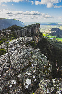
The Grampians National Park commonly referred to as The Grampians, is a national park located in the Grampians region of Victoria, Australia. It lies within the region known as Gariwerd by Aboriginal Victorians of the area; Gariwerd extends across a wider area than the national park.

Stawell, is an Australian town in the Wimmera region of Victoria 237 kilometres (147 mi) west-north-west of the state capital, Melbourne. Located within the Shire of Northern Grampians local government area, it is a seat of local government for the shire and its main administrative centre. At the 2016 census, Stawell had a population of 6,032.

Nhill is a town in the Wimmera, in western Victoria, Australia. Nhill is located on the Western Highway, halfway between Adelaide and Melbourne. At the 2016 census, Nhill had a population of 1,749. "Nhill" is believed to be a Wergaia word meaning "early morning mist rising over water" or "white mist rising from the water".

Dimboola is a town in the Shire of Hindmarsh in the Wimmera region of western Victoria, Australia, 334 kilometres north-west of Melbourne. At the Australian 2016 census Dimboola had a population of 1,424.

Ararat is a city in south-west Victoria, Australia, about 198 kilometres (120 mi) west of Melbourne, on the Western Highway on the eastern slopes of the Ararat Hills and Cemetery Creek valley between Victoria's Western District and the Wimmera. Its urban population according to 2016 census is 8,297 and services the region of 11,752 residents across the Rural City's boundaries. It is also the home of the 2018/19 GMGA Golf Championship Final.
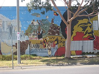
Native title is the designation given to the common law doctrine of Aboriginal title in Australia, which is the recognition by Australian law that Indigenous Australians have rights and interests to their land that derive from their traditional laws and customs. The concept recognises that in certain cases there was and is a continued beneficial legal interest in land held by Indigenous peoples which survived the acquisition of radical title to the land by the Crown at the time of sovereignty. Native title can co-exist with non-Aboriginal proprietary rights and in some cases different Aboriginal groups can exercise their native title over the same land.
Hamilton is a large town in south-western Victoria, Australia, at the intersection of the Glenelg Highway and the Henty Highway. The Hamilton Highway connects it to Geelong.

Halls Gap is a town in Victoria, Australia. It is located on Grampians Road, adjacent to the Grampians National Park, in the Shire of Northern Grampians local government area. The town is set in the Fyans Valley at the foot of the Wonderland and Mount William ranges. At the 2016 census Halls Gap had a population of 430. The approximate driving time from Melbourne is 3 hours.

St Arnaud is a town in the Wimmera region of Victoria, Australia, 244 kilometres north west of the capital Melbourne. It is in the Shire of Northern Grampians local government area. At the 2011 census, St Arnaud had a population of 2,619.

Kaniva is a town in Victoria, Australia. It is located on the Western Highway, north of Little Desert National Park, in the Shire of West Wimmera local government area. It is located roughly 25 kilometres (16 mi) east of the South Australian border and 43 kilometres (27 mi) east of Bordertown. At the 2016 census, Kaniva had a population of 803. The town is commonly used as a rest point for those travelling between Melbourne and Adelaide. The Kaniva region has some rare flora and fauna. The rare south-eastern red-tailed black cockatoo is found in the region. The Shire of West Wimmera prohibits the felling of dead trees to ensure that they have adequate nesting sites.

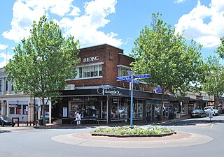
Horsham is a regional city in the Wimmera region of western Victoria, Australia. Located on a bend in the Wimmera River, Horsham is approximately 300 kilometres (190 mi) northwest of the state capital Melbourne. In June 2018, Horsham had an estimated population of 16,514. It is the most populous city in Wimmera, and the main administrative centre for the Rural City of Horsham local government area. It is the eleventh largest city in Victoria after Melbourne, Geelong, Ballarat, Bendigo, Wodonga, Mildura, Shepparton, Warrnambool, Traralgon, and Wangaratta.

Donald is a town in Victoria, Australia, located on the Richardson River, at the junction of Sunraysia Highway and Borung Highway, in the Shire of Buloke. At the 2016 census, it had a population of 1,498.

The Yorta Yorta, also known as Jotijota, are an Aboriginal Australian people who have traditionally inhabited the area surrounding the junction of the Goulburn and Murray Rivers in present-day north-eastern Victoria and southern New South Wales.
Land councils, also known as Aboriginal land councils, or land and sea councils, are Australian community organisations, generally organised by region, that are commonly formed to represent the Indigenous Australians who occupied their particular region before the arrival of European settlers. They have historically advocated for recognition of traditional land rights, and also for the rights of Indigenous people in other areas such as equal wages and adequate housing. They are created under the Aboriginal Land Rights Act 1976.
The Jardwadjali (Yartwatjali), also known as the Jaadwa, are an Aboriginal Australian people of the state of Victoria, whose traditional lands occupy the lands in the upper Wimmera River watershed east to Gariwerd (Grampians) and west to Lake Bringalbert.

Parnngurr is a medium-sized Aboriginal community, located 370 km from Newman in the Pilbara region of Western Australia, within the Shire of East Pilbara. Parnngurr was originally known as Cotton Creek, the name of the ephemeral creek that runs beside the community.

Timber Creek is an isolated small town on the banks of the Victoria River in the Northern Territory of Australia. The Victoria Highway passes through the town, which is the only significant settlement between the Western Australia border and the town of Katherine to the east. Timber Creek is approximately 600 kilometres (370 mi) south of Darwin, in an area known for its scenic escarpments and Boab trees.
A Registered Aboriginal Party (RAP) is a recognised representative body of an Aboriginal Australian people per the Aboriginal Heritage Act 2006. These bodies act as the "primary guardians, keepers and knowledge holders of Aboriginal cultural heritage". They protect and manage the Aboriginal cultural heritage in Victoria, Australia.

Pink Lake is a small, circular, salty pink lake on the Western Highway just north of Dimboola in Australia. Granville Stapylton, part of the explorer Thomas Mitchell's 1836 expedition into western Victoria, reconnoitered Pink Lake on 20 July 1836.
