This article describes the history of the Australian colony and state of Victoria.

Phillip Island is an Australian island about 140 km (87 mi) south-southeast of Melbourne, Victoria. The island was named after Governor Arthur Phillip, the first Governor of New South Wales, by explorer and seaman George Bass, who sailed in an open whale boat, arriving from Sydney on 5 January 1798.

The Wurundjeri are indigenous descendants of the people of the Indigenous Australian nation of the Wurundjeri language group, in the Kulin alliance. They occupied the Birrarung Valley. Its tributaries are the present location of Melbourne. Before European settlement, they lived predominantly as aquaculturists, swidden agriculturists, and hunters and gatherers. Seasonal changes in the weather, availability of foods and other factors would determine where campsites were located, many near the Birrarung and its tributaries.

The Bass Coast Shire is a local government area in Victoria, Australia, located in the south-eastern part of the state. It covers an area of 864 square kilometres (334 sq mi) and, at the 2016 Census, had a population of 32,804. It includes the towns of Bass, Cape Paterson, Cape Woolamai, Corinella, Coronet Bay, Cowes, Inverloch, Kilcunda, Lang Lang, Newhaven, Rhyll, San Remo, Summerlands and Wonthaggi as well as the historic locality of Krowera. It also includes the popular tourist destination, Phillip Island. It was formed in 1994 from the amalgamation of the Shire of Bass, Shire of Phillip Island, Borough of Wonthaggi, parts of the Shire of Woorayl, Shire of Korumburra and City of Cranbourne.
Indented Head is a small coastal township located on the Bellarine Peninsula, east of Geelong, in the Australian state of Victoria. The town lies on the coast of the Port Phillip bay between the towns of Portarlington and St Leonards.
The Boon wurrung, commonly written Bunurong, are Indigenous Australians of the Kulin nation, who occupy South-Central Victoria, Australia. Before British settlement, they lived as all people of the Kulin nation lived, sustainably on the land, predominantly as hunters and gatherers, for tens of thousands of years. They were referred to by Europeans as the Western Port or Port Philip tribe and were in alliance with other tribes in the Kulin nation, having particularly strong ties to the Wurundjeri people.

The Werribee River is a perennial river of the Port Phillip catchment that is located on the plain west of Melbourne, Victoria, Australia. The headwaters of a tributary, the Lerderderg River, are north of Ballan near Daylesford and it flows across the basalt plain, through the suburb of Werribee to enter Port Phillip. A linear park follows the Werribee River along much of its course. In total the Werribee River completes a journey of approximately 110 kilometres (68 mi).

The Taungurong people, also known as the Daung Wurrung, were thirteen clans who spoke the Daungwurrung language and were part of the Kulin alliance of indigenous Australians. They lived to the north of and were closely associated with the Woiwurrung speaking Wurundjeri people. Their territory was to the north of the Great Dividing Range in the watersheds of the Broken, Delatite, Coliban, Goulburn and Campaspe Rivers. They were also known by white settlers as the Devil's River Tribe or Goulburn River Tribe.

Derrimut, was a headman or arweet of the Boonwurrung (Bunurong) people from the Melbourne area of Australia.
Coranderrk was a government reserve for Australian Aborigines in the state of Victoria between 1863 and 1924, located 50 km north-east of Melbourne.
The Bunurong Marine National Park is a protected marine national park located off the coast of Cape Paterson in the South Gippsland region of Victoria, Australia. The 2,100-hectare (5,200-acre) marine national park is located about 6 kilometres (3.7 mi) southwest of Inverloch and about 5 kilometres (3.1 mi) off the coastline. The coastal waters protect a range of habitats including intertidal reefs, subtidal rocky reefs, algal gardens and seagrass beds. The waters are cool, akin to Victoria’s central and western coasts. However, they are relatively protected from south-westerly swells due to the location of far away King Island, Tasmania.
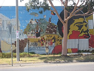
Land councils, also known as land and sea councils, are Australian community organisations, generally organised by region, that are commonly formed to represent the Indigenous Australians who occupied their particular region before the arrival of European settlers. They have historically advocated for recognition of traditional land rights, and also for the rights of Indigenous people in other areas such as equal wages and adequate housing. Some states, such as the Northern Territory, have laws that provide for the existence of land councils and allocate them responsibilities for representing Aboriginal people in various matters. Other states do not have such laws, or have laws that provide for the existence of Aboriginal organisations that do not call themselves land councils to provide functions similar to those provided by land councils in some states. An example of this is in Victoria, where there are laws providing for organisations called 'Registered Aboriginal Parties', which provide functions in relation to Aboriginal people similar to those provided by land councils in, say, the Northern Territory.

The Wurundjeri Tribe Land and Compensation Cultural Heritage Council was established in 1985 by descendants of the Wurundjeri people who are the traditional custodians of the country around Melbourne. There are three family groups in the council: the Nevins, Terricks and Wandins with 30 elders and about 60 members.

Aboriginal Victorians, the indigenous Australians of Victoria, Australia, occupied the land for tens of thousands of years prior to European settlement. Aboriginal people have lived a semi-nomadic existence of fishing, hunting and gathering, and farming eels in Victoria for at least 40,000 years.
Ian D. Clark is an academic historian and Toponymist whose primary work has focused on Victorian Aboriginal history, aboriginal toponymy and the frontier conflict between Indigenous Australians and immigrant settlers during the European settlement of Victoria, Australia.

The Bunurong Marine and Coastal Park collectively are a marine park and a coastal park located along the reef and coast of Harmers Haven, Cape Paterson and Inverloch in the South Gippsland region of Victoria, Australia. Collectively, the parks are located approximately 140 kilometres (87 mi) southeast of Melbourne, between Coal Point in the west to Wreck Creek in the east, and are used for walking, picnicking, boating, education and research.
The Wathaurung Aboriginal Corporation, a Registered Aboriginal Party since 21 May 2009, represents the indigenous people for the Geelong and Ballarat areas. Their responsibility includes ensuring that the Aboriginal culture is maintained there. The organization trades as Wadawurrung or Wathaurung.

Griffiths Island, sometimes incorrectly spelled as Griffith Island, lies at the mouth of the Moyne River next to, and within the bounds of, the town of Port Fairy, in the Western District of the state of Victoria in Australia. Griffiths now has no permanent inhabitants, but is connected to the mainland by a causeway and is accessible on foot. It forms part of the Port Fairy and Belfast Coastline Protection Reserve and, as well as being a tourist attraction, is an important site in the context of the history of European settlement of western Victoria. It is managed by the Moyne Shire Council.
The Kurung were identified as an indigenous Australian group of the State of Victoria by Norman Tindale. The theory that they constituted an independent tribe has been challenged with modern scholarship generally considering them as a clan, associated to one of two major tribes. Their language is unconfirmed.