Related Research Articles
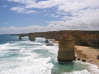
The Western District comprises western regions of the Australian state of Victoria. It is said to be an ill–defined district, sometimes incorrectly referred to as an economic region,. The district is located within parts of the Barwon South West and the Grampians regions; extending from the south-west corner of the state to Ballarat in the east and as far north as Ararat. The district is bounded by the Wimmera district in the north, by the Goldfields district in the east, by Bass Strait and the Southern Ocean in the south, and by the South Australian border in the west. The district is well known for the production of wool. The most populated city in the Western District is the Ballarat region, with 96,940 inhabitants.
Aldo Massola was an Italian-Australian anthropologist, a curator at the National Museum of Victoria in Melbourne from 1954 to 1964, who overcame scandal in his personal life to author a number of influential books about Aboriginal Victorians.

Lake Bolac is a town in the Western District region of Victoria, Australia. The town is on the shores of Lake Bolac, and the Glenelg Highway passes through the town. At the 2021 census, Lake Bolac and the surrounding area had a population of 368.
The Gunditjmara or Gunditjamara, also known as Dhauwurd Wurrung, are an Aboriginal Australian people of southwestern Victoria. They are the traditional owners of the areas now encompassing Warrnambool, Port Fairy, Woolsthorpe and Portland. Their land includes much of the Budj Bim heritage areas. The Kerrup Jmara are a clan of the Gunditjmara, whose traditional lands are around Lake Condah. The Koroitgundidj are another clan group, whose lands are around Tower Hill.

Aboriginal stone arrangements are a form of rock art constructed by Aboriginal Australians. Typically, they consist of stones, each of which may be about 30 centimetres (12 in) in size, laid out in a pattern extending over several metres or tens of metres. Notable examples have been made by many different Australian Aboriginal cultures, and in many cases are thought to be associated with spiritual ceremonies.

Bora is an initiation ceremony of the Aboriginal people of Eastern Australia. The word "bora" also refers to the site on which the initiation is performed. At such a site, boys, having reached puberty, achieve the status of men. The initiation ceremony differs from Aboriginal culture to culture, but often, at a physical level, involved scarification, circumcision, subincision and, in some regions, also the removal of a tooth. During the rites, the youths who were to be initiated were taught traditional sacred songs, the secrets of the tribe's religious visions, dances, and traditional lore. Many different clans would assemble to participate in an initiation ceremony. Women and children were not permitted to be present at the sacred bora ground where these rituals were undertaken.

William Thomas represented Aboriginal people in various roles in the Port Phillip district in Australia.

Ebenezer Mission, also known as Wimmera mission, Hindmarsh mission and Dimboola mission, was a mission station for Aboriginal people established near Lake Hindmarsh in Victoria, Australia in 1859 by the Moravian Church on the land of the Wotjobaluk. The first missionaries were two Germans, Reverend Friedrich Hagenauer and Reverend F.W. Spieseke. In 1861 the Victorian Colonial Government gazetted 1,897 acres (7.68 km2) as a reserve for the Ebenezer Mission Station. The mission was established a few years after the failure of the Moravian Lake Boga mission in Wemba-Wemba territory.
The Djab Wurrung, also spelt Djabwurrung, Tjapwurrung, Tjap Wurrung, or Djapwarrung, people are Aboriginal Australians whose country is the volcanic plains of central Victoria from the Mount William Range of Gariwerd in the west to the Pyrenees range in the east encompassing the Wimmera River flowing north and the headwaters of the Hopkins River flowing south. The towns of Ararat, Stawell and Hamilton are within their territory. There were 41 Djab Wurrung clans who formed an alliance with the neighbouring Jardwadjali people through intermarriage, shared culture, trade and moiety system before colonisation. Their lands were conquered but never ceded.
The Djargurd Wurrong are Aboriginal Australian people of the Western district of the State of Victoria, and traditionally occupied the territory between Mount Emu Creek and Lake Corangamite.

The Gadubanud (Katubanut), also known as the Pallidurgbarran, Yarro waetch or Cape Otway tribe (Tindale), are an Aboriginal Australian people of the state of Victoria. Their territory encompasses the rainforest plateau and rugged coastline of Cape Otway. Their numbers declined rapidly following the onset of European colonisation, and little is known of them. However, some may have found refuge at the Wesleyan mission station at Birregurra, and later the Framlingham mission station, and some people still trace their descent from them.
Aboriginal Victorians, the Aboriginal Australians of Victoria, Australia, occupied the land for tens of thousands of years prior to European settlement. Aboriginal people have lived a semi-nomadic existence of fishing, hunting and gathering, and farming eels in Victoria for at least 40,000 years.
Wurdi Youang is the name attributed to an Aboriginal stone arrangement located off the Little River – Ripley Road at Mount Rothwell, near Little River, Victoria in Australia. The site was acquired by the Indigenous Land Corporation on 14 January 2000 and transferred to the Wathaurong Aboriginal Co-operative on 17 August 2006.

Aboriginal sites of Victoria form an important record of human occupation for probably more than 40,000 years. They may be identified from archaeological remains, historical and ethnographic information or continuing oral traditions and encompass places where rituals and ceremonies were performed, occupation sites where people ate, slept and carried out their day to day chores, and ephemeral evidence of people passing through the landscape, such as a discarded axe head or isolated artefact.
The Carisbrook stone arrangement is a well-preserved Aboriginal stone arrangement in Victoria, Australia. It measures 60 by 5 metres and is one of only four stone arrangements in the state and the only one of a boomerang design. It is located about 5 km south-east of the town of Carisbrook, on the banks of Tullaroop Creek.
The Minjambuta were an Indigenous Australian tribe of northern Victoria.
The Eumeralla Wars were the violent encounters over the possession of land between British colonists and Gunditjmara Aboriginal people in what is now called the Western District area of south west Victoria.
Budj Bim heritage areas includes several protected areas in Victoria, Australia, the largest two being Budj Bim National Heritage Landscape and the Budj Bim Cultural Landscape. Within the latter, there are three Indigenous Protected Areas: the Tyrendarra Indigenous Protected Area, Kurtonitj Indigenous Protected Area, and the Lake Condah Indigenous Protected Area.
Lake Condah Mission, also known as Condah Mission, was established in 1867 as a Church of England mission, approximately 3 kilometres (1.9 mi) from Lake Condah, which was traditionally known as Tae Rak, and about 20 kilometres (12 mi) to 25 kilometres (16 mi) south-east of the small town of Condah. The site of the mission, on 2,000 acres (810 ha) north of Darlot Creek, was formally reserved in 1869, and the Mission continued operations until the reserve was finally revoked in 1951, with most of the land handed over to the Soldiers Settlement Scheme to provide land for white veterans of World War II.
References
- 1 2 Flanagan, Martin (2 January 2009). "The lady of the lake". The Age. Retrieved 20 December 2019.
- 1 2 3 Wahlquist, Calla (6 April 2021). "Traditional owners devastated by alleged damage to 1,500-year-old stone arrangement in Victoria". The Guardian. Retrieved 7 April 2021.
- ↑ Aboriginal Affairs Victoria, Miniposters #10: Stone Arrangements Archived 4 March 2011 at the Wayback Machine
- ↑ Long, A. & Schell, P., 1999, 'Lake Bolac stone arrangement (AAV 7422-394); management plan'. Aboriginal Affairs Victoria: 20-21
- ↑ Aboriginal stone structures in southwestern Victoria report to Aboriginal Affairs Victoria Sharon Lane Revised December 2009 Archived 25 June 2012 at the Wayback Machine
- ↑ Lane, L. and R.L.K. Fullagar 1980 Previously unrecorded Aboriginal stone alignments in Victoria Records of the Victorian Archaeological Survey 10:134-151
- ↑ Massola 1968
- ↑ James Dawson, Australian Aborigines 1881.
- ↑ Johnson, Sian; Bewley, Caitlin (5 April 2021). "Aboriginal group 'traumatised' by alleged partial destruction of ancient Lake Bolac eel-shaped stone arrangement". ABC News. Australian Broadcasting Corporation. Retrieved 5 April 2021.
- ↑ "Grampians:Lake Bolac Eel Festival". Visit Melbourne. Archived from the original on 18 October 2011.