Barnum, Minnesota

Last updated

Barnum
Barnum, Minnesota-commercial area at Main Street.jpg
Commercial area at Main Street
Carlton County Minnesota Incorporated and Unincorporated areas Barnum Highlighted.svg
Location of the city of Barnum
within Carlton County, Minnesota
Coordinates: 46°30′15″N92°41′26″W / 46.50417°N 92.69056°W / 46.50417; -92.69056
Country United States
State Minnesota
County Carlton
Area
[1]
  Total1.01 sq mi (2.61 km2)
  Land1.01 sq mi (2.61 km2)
  Water0.00 sq mi (0.00 km2)
Elevation
1,106 ft (337 m)
Population
 (2020)
  Total620
  Density614.47/sq mi (237.29/km2)
Time zone UTC-6 (Central (CST))
  Summer (DST) UTC-5 (CDT)
ZIP code
55707
Area code 218
FIPS code 27-03628 [2]
GNIS feature ID0639642 [3]
Website barnummn.us

Barnum is a city in Carlton County, Minnesota, United States. The population was 613 at the 2010 census. [4]

Contents

Interstate Highway 35, Carlton County Road 6 (Main Street), and Carlton County Road 61 (Front Street) are three of the main routes in Barnum.

Geography

According to the United States Census Bureau, the city has an area of 1,000 square miles (2,589.99 km2), all land. [5] It is five miles northeast of Moose Lake and 33 miles southwest of Duluth.

Community

Barnum is the home of the Carlton County Fair. The Fair takes place annually in August, having been first founded in 1890. Barnum is also home to the Barnum elementary and Barnum high school.

Demographics

Historical population
CensusPop.Note
1880 49
1890 417751.0%
1900 391−6.2%
1910 262−33.0%
1920 242−7.6%
1930 27112.0%
1940 32720.7%
1950 3445.2%
1960 41721.2%
1970 382−8.4%
1980 46421.5%
1990 4823.9%
2000 5258.9%
2010 61316.8%
2020 6201.1%
U.S. Decennial Census [6]

2010 census

As of the census [7] of 2010, there were 613 people, 236 households, and 152 families living in the city. The population density was 613.0 inhabitants per square mile (236.7/km2). There were 264 housing units at an average density of 264.0 per square mile (101.9/km2). The racial makeup of the city was 92.0% White, 0.3% African American, 2.4% Native American, 0.2% Asian, and 5.1% from two or more races. Hispanic or Latino of any race were 0.8% of the population.

There were 236 households, of which 38.6% had children under the age of 18 living with them, 46.2% were married couples living together, 12.7% had a female householder with no husband present, 5.5% had a male householder with no wife present, and 35.6% were non-families. 30.9% of all households were made up of individuals, and 14.9% had someone living alone who was 65 years of age or older. The average household size was 2.57 and the average family size was 3.24.

The median age in the city was 35.2 years. 32.5% of residents were under the age of 18; 5.6% were between the ages of 18 and 24; 27.6% were from 25 to 44; 21.4% were from 45 to 64; and 13.1% were 65 years of age or older. The gender makeup of the city was 46.7% male and 53.3% female.

2000 census

As of the census [2] of 2000, there were 525 people, 226 households, and 138 families living in the city. The population density was 519.7 inhabitants per square mile (200.7/km2). There were 249 housing units at an average density of 246.5 per square mile (95.2/km2). The racial makeup of the city was 97.33% White, 1.52% Native American, and 1.14% from two or more races. Hispanic or Latino of any race were 0.19% of the population. 20.0% were of Norwegian, 17.2% German, 13.0% American, 11.7% Swedish and 6.7% Finnish ancestry according to Census 2000.

There were 226 households, out of which 34.5% had children under the age of 18 living with them, 43.4% were married couples living together, 14.2% had a female householder with no husband present, and 38.9% were non-families. 31.0% of all households were made up of individuals, and 16.4% had someone living alone who was 65 years of age or older. The average household size was 2.32 and the average family size was 2.96.

In the city, the population was spread out, with 29.1% under the age of 18, 8.8% from 18 to 24, 30.1% from 25 to 44, 16.8% from 45 to 64, and 15.2% who were 65 years of age or older. The median age was 33 years. For every 100 females, there were 94.4 males. For every 100 females age 18 and over, there were 84.2 males.

The median income for a household in the city was $31,518, and the median income for a family was $40,625. Males had a median income of $34,375 versus $21,250 for females. The per capita income for the city was $14,621. About 7.4% of families and 9.4% of the population were below the poverty line, including 10.8% of those under age 18 and 8.0% of those age 65 or over.

Related Research Articles

<span class="mw-page-title-main">Barnum, Iowa</span> City in Iowa, United States

Barnum is a city in Webster County, Iowa, United States, just off U.S. Route 20. The population was 175 at the 2020 census.

<span class="mw-page-title-main">Carlton, Kansas</span> City in Dickinson County, Kansas

Carlton is a city in Dickinson County, Kansas, United States. As of the 2020 census, the population of the city was 40.

<span class="mw-page-title-main">Hurlock, Maryland</span> Town in Maryland, United States

Hurlock is a town in Dorchester County, Maryland, United States. The population was 2,092 at the 2010 census.

<span class="mw-page-title-main">Burt Township, Cheboygan County, Michigan</span> Civil township in Michigan, United States

Burt Township is a civil township of Cheboygan County in the U.S. state of Michigan. As of the 2010 census, the township population was 680.

Barnum Township is a township in Carlton County, Minnesota, United States. The population was 978 as of the 2000 census. Barnum Township was named for George G. Barnum, a railroad official.

<span class="mw-page-title-main">Carlton, Minnesota</span> City in Minnesota, United States

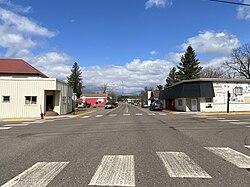
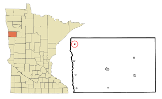
Carlton is a city in Carlton County, Minnesota, United States. The population was 948 at the 2020 census. It is the county seat of Carlton County. The town sits on the northwestern edge of Jay Cooke State Park.

<span class="mw-page-title-main">Kettle River, Minnesota</span> City in Minnesota, United States

Kettle River is a city in Carlton County, Minnesota, along the Kettle River, for which it was named. The population was 180 at the time of the 2010 census. It was incorporated in 1921.

<span class="mw-page-title-main">Scanlon, Minnesota</span> City in Minnesota, United States

Scanlon is a city in Carlton County, Minnesota, United States. The population was 987 at the 2020 census.

Skelton Township is a township in Carlton County, Minnesota, United States. The population was 372 as of the 2000 census. Skelton Township was named for John and Harry E. Skelton, two brothers who were both employed as county officials.

<span class="mw-page-title-main">Thomson, Minnesota</span> Former City in Minnesota, United States

Thomson was a city in Carlton County, Minnesota, United States, located along the Saint Louis River. The population was 159 at the 2010 census.

<span class="mw-page-title-main">Wrenshall, Minnesota</span> City in Minnesota, United States

Wrenshall is a city in Carlton County, Minnesota, United States. It was originally a brickyard. The population was 428 at the 2020 census. Wrenshall is located just south of Jay Cooke State Park.

<span class="mw-page-title-main">Wright, Minnesota</span> City in Minnesota, United States

Wright is a city in Carlton County, Minnesota, United States. The population was 127 at the 2010 census.

<span class="mw-page-title-main">Shelly, Minnesota</span> City in Minnesota, United States

Shelly is a city in Norman County, Minnesota, United States. The population was 179 at the 2020 census.

Prairie Lake Township is a township in Saint Louis County, Minnesota, United States. The population was 50 at the 2010 census.

<span class="mw-page-title-main">Springdale, Ohio</span> City in Ohio, United States

Springdale is a city in Hamilton County, Ohio, United States. It is a suburb of Cincinnati. The population was 11,007 at the 2020 census.

<span class="mw-page-title-main">Ryan Township, Pennsylvania</span> Township in Pennsylvania, United States

Ryan Township is a township in Schuylkill County, Pennsylvania, United States. The population was 2,526 at the 2020 census.

<span class="mw-page-title-main">Gregory, South Dakota</span> City in South Dakota, United States

Gregory is a city in western Gregory County, South Dakota, United States. The population was 1,221 at the 2020 census.

<span class="mw-page-title-main">Oliver, Wisconsin</span> Village in Wisconsin, United States

Oliver is a village in Douglas County, Wisconsin, United States. The population was 423 at the 2020 census.

<span class="mw-page-title-main">Random Lake, Wisconsin</span> Village in Wisconsin, United States

Random Lake is a village in Sheboygan County, Wisconsin, United States. The population was 1,594 at the 2010 census. It is part of the Sheboygan, Wisconsin Metropolitan Statistical Area.

Clear Creek is an unorganized territory in Carlton County, Minnesota, United States, located near Holyoke. The population was 118 at the 2000 census.

References

  1. "2020 U.S. Gazetteer Files". United States Census Bureau. Retrieved July 24, 2022.
  2. 1 2 "U.S. Census website". United States Census Bureau . Retrieved January 31, 2008.
  3. "US Board on Geographic Names". United States Geological Survey. October 25, 2007. Retrieved January 31, 2008.
  4. "2010 Census Redistricting Data (Public Law 94-171) Summary File". American FactFinder. U.S. Census Bureau, 2010 Census. Retrieved April 23, 2011.[ dead link ]
  5. "US Gazetteer files 2010". United States Census Bureau. Archived from the original on January 25, 2012. Retrieved November 13, 2012.
  6. "Census of Population and Housing". Census.gov. Retrieved June 4, 2015.
  7. "U.S. Census website". United States Census Bureau . Retrieved November 13, 2012.

46°30′11″N92°41′19″W / 46.50306°N 92.68861°W / 46.50306; -92.68861