
The Town of Lac du Flambeau is located in Vilas County, Wisconsin, United States. The population was 3,004 at the 2000 census. The land base of the Lac du Flambeau Band of Lake Superior Chippewa is located within the town and also consists of a large portion of the town. The Lac du Flambeau census-designated place is located within the town. The unincorporated community of Marlands is also located in the town. Lac du Flambeau, situated around Flambeau Lake, is a year-round vacation destination.

The Red Lake Indian Reservation covers 1,260.3 sq mi in parts of nine counties in Minnesota, United States. It is made up of numerous holdings but the largest section is an area around Red Lake, in north-central Minnesota, the largest lake in the state. This section lies primarily in the counties of Beltrami and Clearwater. Land in seven other counties is also part of the reservation. The reservation population was 5,506 in the 2020 census.

The L'Anse Indian Reservation is the land base of the federally recognized Keweenaw Bay Indian Community of the historic Lake Superior Band of Chippewa Indians.. The reservation is located primarily in two non-contiguous sections on either side of the Keweenaw Bay in Baraga County in the Upper Peninsula of the U.S. state of Michigan. The Keweenaw Bay Community also manages the separate Ontonagon Indian Reservation.

The Lac du Flambeau Band of Lake Superior Chippewa is a federally recognized Ojibwa Native American tribe. It had 3,415 enrolled members as of 2010. The Lac du Flambeau Indian Reservation lies mostly in the Town of Lac du Flambeau in south-western Vilas County, and in the Town of Sherman in south-eastern Iron County in the U.S. state of Wisconsin. It has a land area of 107.1 square miles (277.4 km2) and a 2020 census resident population of 3,518. Its major settlement is the unincorporated Lac du Flambeau, which had a population of 1,845.

The Bad River LaPointe Band of the Lake Superior Tribe of Chippewa Indians or Bad River Tribe for short are a federally recognized tribe of Ojibwe people. The tribe had 6,945 members as of 2010. The Bad River Reservation is located on the south shore of Lake Superior and has a land area of about 193.11 square miles (500.15 km2) in northern Wisconsin, straddling Ashland and Iron Counties. Odanah, the administrative and cultural center, is located 5 miles (8 km) east of the town of Ashland on U.S. Highway 2. The reservation population was 1,545 in 2020. Most of the reservation is managed as undeveloped forest and wetland, providing a habitat for wild rice and other natural resources.

The White Earth Indian Reservation is home to the White Earth Band, in northwestern Minnesota. It is the largest Indian reservation in the state by land area. The reservation includes all of Mahnomen County, plus parts of Becker and Clearwater counties in the northwest part of the state along the Wild Rice and White Earth rivers. The reservation's land area is 1,093 square miles (2,830 km2). The population was 9,726 as of the 2020 census, including off-reservation trust land. The White Earth Indian Reservation is one of six bands that make up the Minnesota Chippewa Tribe, their governing body for major administrative needs. It is about 225 miles (362 km) from Minneapolis–Saint Paul and roughly 65 miles (105 km) from Fargo–Moorhead.
Fond du Lac Band of Lake Superior Chippewa is an Anishinaabe (Ojibwe) band located near Cloquet, Minnesota. Their land base is the Fond du Lac Indian Reservation, located mainly in Carlton and Saint Louis Counties, Minnesota, 20 miles west of Duluth.
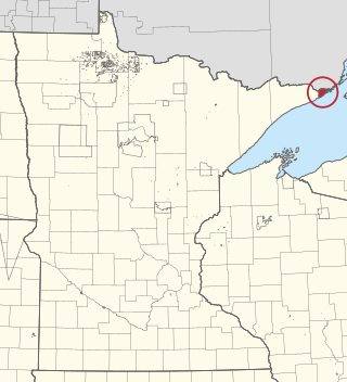
The Grand Portage Indian Reservation is the Indian reservation of the Grand Portage Band of Minnesota Chippewa Tribe, a federally recognized tribe in Minnesota.
Mille Lacs Indian Reservation is the popular name for the land-base for the Mille Lacs Band of Ojibwe in Central Minnesota, about 100 miles (160 km) north of Minneapolis-St. Paul. The contemporary Mille Lacs Band reservation has significant land holdings in Mille Lacs, Pine, Aitkin and Crow Wing counties, as well as other land holdings in Kanabec, Morrison, and Otter Tail Counties. Mille Lacs Indian Reservation is also the name of a formal Indian reservation established in 1855. It is one of the two formal reservations on which the contemporary Mille Lacs Band retains land holdings. The contemporary Mille Lacs band includes several aboriginal Ojibwe bands and villages, whose members reside in communities throughout central Minnesota.

The Lac Courte Oreilles Tribe is one of six federally recognized bands of Ojibwe people located in present-day Wisconsin. It had 7,275 enrolled members as of 2010. The band is based at the Lac Courte Oreilles Indian Reservation in northwestern Wisconsin, which surrounds Lac Courte Oreilles. The main reservation's land is in west-central Sawyer County, but two small plots of off-reservation trust land are located in Rusk, Burnett, and Washburn counties. The reservation was established in 1854 by the second Treaty of La Pointe.
The Grand Traverse Band of Ottawa and Chippewa Indians is a federally recognized Native American tribe located in northwest Michigan on the Leelanau Peninsula. Sandra Witherspoon is the current tribal chairperson, elected in May 2024 to a four-year term after succeeding David Arroyo, who served a single term from 2020 to 2024.

The Treaty of La Pointe may refer to either of two treaties made and signed in La Pointe, Wisconsin between the United States and the Ojibwe (Chippewa) Native American peoples. In addition, the Isle Royale Agreement, an adhesion to the first Treaty of La Pointe, was made at La Pointe.
The Lake Superior Chippewa are a large number of Ojibwe (Anishinaabe) bands living around Lake Superior; this territory is considered part of northern Michigan, Wisconsin, and Minnesota in the United States. They migrated into the area by the seventeenth century, encroaching on the Eastern Dakota people who had historically occupied the area. The Ojibwe defeated the Eastern Dakota, who migrated west into the Great Plains after the final battle in 1745. While they share a common culture including the Anishinaabe language, this highly decentralized group of Ojibwe includes at least twelve independent bands in the region.
Lac Vieux Desert Band of Lake Superior Chippewa is a federally recognized band of the Lake Superior Chippewa, many of whom reside on the Lac Vieux Desert Indian Reservation, located near Watersmeet, Michigan. It is approximately 45 miles southeast of Ironwood, Michigan in Gogebic County.
The St. Croix Chippewa Indians of Wisconsin are a federally recognized tribe of Ojibwe people located in Northwest Wisconsin, along the St. Croix River valley and watershed. The band had 1,054 members as of 2010.
Anishinaabe tribal political organizations are political consortiums of Anishinaabe nations that advocate for the political interests of their constituencies. Anishinaabe people of Canada are considered as First Nations, and of the United States as Native Americans.
The Great Lakes Indian Fish & Wildlife Commission (GLIFWC) is an intertribal, co-management agency committed to the implementation of off-reservation treaty rights on behalf of its eleven-member Ojibwa tribes. Formed in 1984 and exercising authority specifically delegated by its member tribes, GLIFWC's mission is to help ensure significant off-reservation harvests while protecting the resources for generations to come.
The 1854 Treaty Authority is an inter-tribal natural resource management organization committed to protecting and implementing the off-reservation hunting, fishing, and gathering rights for the Bois Forte Band of Chippewa and the Grand Portage Band of Chippewa in the lands ceded to the United States government under the Treaty of La Pointe.
Fond du Lac Tribal and Community College (FDLTCC) is a public tribal land-grant community college in Cloquet, Minnesota. FDLTCC is located within the Twin Ports area of Duluth, Minnesota and Superior, Wisconsin in northeastern Minnesota. The college is a member of Minnesota State, the American Indian Higher Education Consortium, and the World Indigenous Nations Higher Education Consortium. FDLTCC was Minnesota's first tribal college. FDLTCC is the only college in the nation both established as a tribal college under federal law and operating as part of a state-funded higher education system.

The 1837 Treaty of St. Peters, commonly referred to as the White Pine Treaty, was a treaty conducted between Governor Henry Dodge for the United States and representatives from Ojibwe bands located across today's Wisconsin and Minnesota. It was conducted on July 29, 1837, at St. Peters, Wisconsin Territory. The treaty was proclaimed on June 15, 1838, and codified in the United States Statutes at Large as 7 Stat. 536.


