Britt, Minnesota

Last updated

Britt
USA Minnesota location map.svg
Red pog.svg
Britt
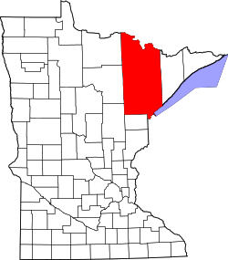
Location of Britt within Saint Louis County
Usa edcp location map.svg
Red pog.svg
Britt
Britt (the United States)
Coordinates: 47°38′25″N92°31′32″W / 47.64028°N 92.52556°W / 47.64028; -92.52556
Country United States
State Minnesota
County Saint Louis
Township Sandy Township
Elevation
1,476 ft (450 m)
Population
 (2010) [1]
  Total1,069
Time zone UTC-6 (Central (CST))
  Summer (DST) UTC-5 (CDT)
ZIP code
55710
Area code 218
GNIS feature ID660881 [2]

Britt is an unincorporated area in Saint Louis County, Minnesota, United States.

Britt is located 11 miles north of the city of Virginia.

The original center of Britt was generally considered at the intersection of Saint Louis County Road 68 and Jarvinen Road (County 662) in the southwest corner of Sandy Township. Britt Creek flows through the area.

Britt, which was once a proper town with only a post office and a carpet store, has evolved into a large community that spans an extended area. It is generally considered the inhabited area north of the city of Virginia, and north-northwest of Wuori Township. The area begins at Highway 169 (MN 169) near Florenton and goes west past U.S. Highway 53 near Sand Lake. However, Britt now also covers the unorganized territory of Sand Lake to the west centered on Highway 53 while the area near Highway 169 consists of the northern part of Wouri Township.

Saint Louis County Roads 65, 68, and 106 (Britt Bypass) are located within the Britt area. [3]

Britt is located within the Superior National Forest.

Natural lakes in the Britt area include Lake Fourteen, Lake Leander, Lake Little Fourteen, Dark Lake, Arrowhead Lake, Sand Lake, Little Sand Lake, Sandy Lake, Little Sandy Lake, Moose Lake, Clear Lake, and a number of smaller lakes. Minntac Tailings Basin Cell One also lies partially in southern Britt.

Related Research Articles

<span class="mw-page-title-main">St. Louis County, Minnesota</span> County in Minnesota, United States

St. Louis County is a county located in the Arrowhead Region of the U.S. state of Minnesota. As of the 2020 census, the population was 200,231. Its county seat is Duluth. It is the largest county in Minnesota by land area, and the largest in the United States by total area east of the Mississippi River, ahead of Aroostook County, Maine.

Angora Township is a township in Saint Louis County, Minnesota, United States. The population was 249 at the 2010 census. Angora Township was named after Angora, in Turkey.

Cotton Township is a township in Saint Louis County, Minnesota, United States. The population was 445 at the 2010 census.

Grand Lake Township is a township in Saint Louis County, Minnesota, United States. The population was 2,779 at the 2010 census.

<span class="mw-page-title-main">Great Scott Township, St. Louis County, Minnesota</span> Township in Minnesota, United States

Great Scott Township is a township in Saint Louis County, Minnesota, United States. The population was 561 at the 2010 census.

Sandy Township is a township in Saint Louis County, Minnesota, United States. The population was 356 at the 2010 census.

Sturgeon Township is a township in Saint Louis County, Minnesota, United States. The population was 140 at the 2010 census.

Vermilion Lake Township is a township in Saint Louis County, Minnesota, United States. The population was 278 at the 2010 census.

Wuori Township is a township in Saint Louis County, Minnesota, United States. The population was 572 at the 2010 census.

<span class="mw-page-title-main">U.S. Route 53</span> U.S. Highway in Minnesota and Wisconsin

U.S. Route 53, or U.S. Highway 53 (U.S. 53), is a north–south U.S. highway that runs for 404 miles (650 km) from La Crosse, Wisconsin to International Falls, Minnesota. It is the primary north–south route in northwestern Wisconsin, serving as a vital link between I-94 at Eau Claire, Wisconsin and the Twin Ports of Superior, Wisconsin, and Duluth, Minnesota. The entire route from Eau Claire to the city limits of Superior is a four lane divided highway. The highway's northern terminus is at the Fort Frances–International Falls International Bridge in International Falls, Minnesota, at the Canada–US border. Its southern terminus is in La Crosse, Wisconsin, at U.S. Highway 14.

<span class="mw-page-title-main">Embarrass, Minnesota</span> Unincorporated community in Minnesota, United States

Embarrass is an unincorporated community in Embarrass Township, Saint Louis County, Minnesota, United States.

Saginaw is an unincorporated area in Saint Louis County, Minnesota, United States. Although unincorporated, Saginaw has a post office with the ZIP code 55779.

Cotton is an unincorporated community in Cotton Township, Saint Louis County, Minnesota, United States.

Central Lakes is an unincorporated community in Saint Louis County, Minnesota, United States.

Burntside is an unincorporated community in Morse Township, Saint Louis County, Minnesota, United States.

Florenton is an unincorporated community in Wuori Township, Saint Louis County, Minnesota, United States; located near Britt.

Four Corners is an unincorporated community in Saint Louis County, Minnesota, United States; located 10 miles northwest of the city of Duluth at the junction of U.S. Highway 53 and Saint Louis County Road 13.

Petrel is an unincorporated community in Fairbanks Township, Saint Louis County, Minnesota, United States; located within the Superior National Forest.

Section Thirty is an unincorporated community in Fall Lake Township, Lake County, Minnesota, United States, located four miles east of Ely and two miles southeast of Winton. It takes its name from the survey section of the survey township in which it is located.

References

  1. "Britt (zip 55710), Minnesota". Best Places. Retrieved February 24, 2017.
  2. "Britt, Minnesota". Geographic Names Information System . United States Geological Survey, United States Department of the Interior.
  3. "Britt Community Historical Society".