Mountain Iron, Minnesota

Last updated

Mountain Iron
Mountain Iron IMG 1410.JPG
This city is founded on the taconite iron ore deposits discovered by Leonidas Merritt in the 1880s.
Motto: 
Taconite Capital of the World
St. Louis County Minnesota Incorporated and Unincorporated areas Mountain Iron Highlighted.svg
Location of the city of Mountain Iron
within Saint Louis County, Minnesota
Coordinates: 47°31′57″N92°37′25″W / 47.53250°N 92.62361°W / 47.53250; -92.62361
CountryUnited States
State Minnesota
County Saint Louis
Founded1892
Incorporated (village)November 28, 1892
Incorporated (city)June 20, 1913
Government
   Mayor Peggy Anderson
Area
[1]
  Total70.89 sq mi (183.61 km2)
  Land68.11 sq mi (176.40 km2)
  Water2.79 sq mi (7.21 km2)
Elevation
[2]
1,480 ft (451 m)
Population
 (2020) [3]
  Total2,878
  Estimate 
(2022) [4]
2,860
  Density42.26/sq mi (16.32/km2)
Time zone UTC–6 (Central (CST))
  Summer (DST) UTC–5 (CDT)
ZIP Codes
55768 and 55792
Area code 218
FIPS code 27-44548
GNIS feature ID0661972 [2]
Sales tax 7.375% [5]
Website mtniron.com

Mountain Iron is a city in Saint Louis County, Minnesota, United States, in the heart of the Mesabi Range. The population was 2,878 at the 2020 census. [3]

Contents

U.S. Highway 169 serves as a main route in Mountain Iron.

The city's motto is "Taconite Capital of the World". The local mine, Minntac, is owned by the United States Steel Corporation (U.S. Steel).

Mountain Iron is part of the Quad Cities, with Virginia, Eveleth, and Gilbert.

History

Mountain Iron was founded in 1892 as a mining village in the former Nichols Township. It was named after the nearby Mountain Iron Mine. [6]

Mountain Iron was incorporated as a city in 1972.

Mountain Iron power plant building and village hall building (2020) Mountain Iron Town Hall.jpg
Mountain Iron power plant building and village hall building (2020)

Geography

According to the United States Census Bureau, the city has an area of 71.31 square miles (184.69 km2); 68.52 square miles (177.47 km2) is land and 2.79 square miles (7.23 km2) is water. [7]

Demographics

Historical population
CensusPop.Note
1900 470
1910 1,343185.7%
1920 1,54615.1%
1930 1,349−12.7%
1940 1,49210.6%
1950 1,377−7.7%
1960 1,80831.3%
1970 1,698−6.1%
1980 4,134143.5%
1990 3,362−18.7%
2000 2,999−10.8%
2010 2,869−4.3%
2020 2,8780.3%
2022 (est.)2,860 [4] −0.6%
U.S. Decennial Census [8]
2020 Census [3]

2010 census

As of the census of 2010, there were 2,869 people, 1,336 households, and 796 families living in the city. The population density was 41.9 inhabitants per square mile (16.2/km2). There were 1,442 housing units at an average density of 21.0 per square mile (8.1/km2). The racial makeup of the city was 96.8% White, 0.3% African American, 0.7% Native American, 0.2% Asian, and 2.0% from two or more races. Hispanic or Latino of any race were 0.6% of the population.

There were 1,336 households, of which 24.8% had children under the age of 18 living with them, 44.7% were married couples living together, 10.3% had a female householder with no husband present, 4.6% had a male householder with no wife present, and 40.4% were non-families. 35.9% of all households were made up of individuals, and 14.4% had someone living alone who was 65 years of age or older. The average household size was 2.14 and the average family size was 2.72.

The median age in the city was 45.4 years. 20.7% of residents were under the age of 18; 7.2% were between the ages of 18 and 24; 21.8% were from 25 to 44; 33% were from 45 to 64; and 17.4% were 65 years of age or older. The gender makeup of the city was 49.8% male and 50.2% female.

2000 census

As of the census of 2000, there were 2,999 people, 1,326 households, and 847 families living in the city. The population density was 60.7 inhabitants per square mile (23.4/km2). There were 1,409 housing units at an average density of 28.5 per square mile (11.0/km2). The racial makeup of the city was 98.30% White, 0.77% Native American, 0.23% Asian, 0.13% from other races, and 0.57% from two or more races. Hispanic or Latino of any race were 0.40% of the population. 27.3% were of Finnish, 11.2% German, 9.8% Italian, 8.8% Norwegian, 6.1% Swedish and 5.1% Slovene ancestry.

There were 1,326 households, out of which 27.6% had children under the age of 18 living with them, 50.2% were married couples living together, 10.1% had a female householder with no husband present, and 36.1% were non-families. 31.2% of all households were made up of individuals, and 13.4% had someone living alone who was 65 years of age or older. The average household size was 2.26 and the average family size was 2.83.

In the city, the population was spread out, with 22.9% under the age of 18, 9.4% from 18 to 24, 24.3% from 25 to 44, 27.9% from 45 to 64, and 15.5% who were 65 years of age or older. The median age was 41 years. For every 100 females, there were 94.0 males. For every 100 females age 18 and over, there were 90.4 males.

The median income for a household in the city was $35,163, and the median income for a family was $52,695. Males had a median income of $41,806 versus $22,837 for females. The per capita income for the city was $18,761. About 7.8% of families and 10.7% of the population were below the poverty line, including 17.0% of those under age 18 and 5.4% of those age 65 or over.

Related Research Articles

Schroeder Township is one of the three townships of Cook County, Minnesota, United States. The population was 187 at the 2000 census. The unincorporated communities of Schroeder and Taconite Harbor are located within the township. The community was named for John Schroeder, a businessperson in the lumber industry.

<span class="mw-page-title-main">Cuyuna, Minnesota</span> City in Minnesota, United States

Cuyuna is a city in Crow Wing County, Minnesota, United States. The population was 332 at the 2010 census. It is part of the Brainerd Micropolitan Statistical Area.

<span class="mw-page-title-main">Winnebago, Minnesota</span> City in Minnesota, United States

Winnebago is a city in Faribault County, Minnesota, United States. The population was 1,391 at the 2020 census.

<span class="mw-page-title-main">Bovey, Minnesota</span> City in Minnesota, United States

Bovey is a city in Itasca County, Minnesota, United States. It is part of Minnesota's Iron Range. The population was 804 at the 2010 census.

<span class="mw-page-title-main">Cohasset, Minnesota</span> City in Minnesota, United States

Cohasset is a city in Itasca County, Minnesota, United States. The population was 2,698 at the 2010 census.

<span class="mw-page-title-main">Coleraine, Minnesota</span> City in Minnesota, United States

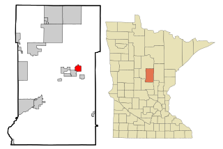
Coleraine is a city in Itasca County, Minnesota, United States. The population was 1,970 at the 2010 census. The community was named after Thomas F. Cole, President of the Oliver Iron Mining Company.

Iron Range Township was a township in Itasca County, Minnesota, United States. The population was 649 at the 2010 census.

<span class="mw-page-title-main">Keewatin, Minnesota</span> City in Minnesota, United States

Keewatin is a city in Itasca County, Minnesota, United States. The population was 1,068 at the 2010 census.

<span class="mw-page-title-main">Taconite, Minnesota</span> City in Minnesota, United States

Taconite is a city in Itasca County, Minnesota, United States. The population was 360 at the 2010 census.

<span class="mw-page-title-main">Silver Bay, Minnesota</span> City in Minnesota, United States

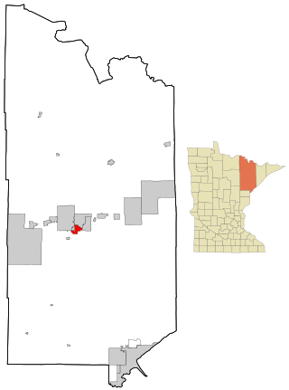
Silver Bay is a city in Lake County, Minnesota, United States. The population was 1,857 at the time of the 2020 census. It is the largest population center in a natural tourism area which includes, Tettegouche State Park and the Split Rock Lighthouse. It is a port along Lake Superior for iron ore and has taconite mining facilities of its own.

<span class="mw-page-title-main">Aurora, Minnesota</span> City in Minnesota, United States

Aurora is a city in Saint Louis County, Minnesota, United States. The population was 1,678 at the 2020 census.

<span class="mw-page-title-main">Babbitt, Minnesota</span> City in Minnesota, United States

Babbitt is a city in Saint Louis County, Minnesota, United States. As of the 2020 census, the city had a population of 1,397.

Cherry Township is a township in Saint Louis County, Minnesota, United States. The population was 860 at the 2010 census.

<span class="mw-page-title-main">Eveleth, Minnesota</span> City in Minnesota, United States

Eveleth is a city in St. Louis County, Minnesota, United States. The population was 3,718 at the 2010 census.

<span class="mw-page-title-main">Gilbert, Minnesota</span> City in Minnesota, United States

Gilbert is a city in St. Louis County, Minnesota, United States. The population was 1,799 at the 2010 census. State Highway 37 and State Highway 135 are two of the main routes in Gilbert. Gilbert is part of the Quad Cities, with Virginia, Eveleth, and Mountain Iron. The city is named for Giles Gilbert, who led the exploration of the McKinley mine property in the 1890s.

<span class="mw-page-title-main">Great Scott Township, St. Louis County, Minnesota</span> Township in Minnesota, United States

Great Scott Township is a township in Saint Louis County, Minnesota, United States. The population was 561 at the 2010 census.

<span class="mw-page-title-main">Kinney, Minnesota</span> City in Minnesota, United States

Kinney is a city in Saint Louis County, Minnesota, United States. The population was 169 at the time of the 2010 census.

Kugler Township is a township in Saint Louis County, Minnesota, United States. The population was 175 at the 2010 census.

<span class="mw-page-title-main">McKinley, St. Louis County, Minnesota</span> City in Minnesota, United States

McKinley is a city in Saint Louis County, Minnesota, United States; located within the Iron Range region of Minnesota. The population was 128 at the 2010 census.

Wuori Township is a township in Saint Louis County, Minnesota, United States. The population was 572 at the 2010 census.

References

  1. "2020 U.S. Gazetteer Files". United States Census Bureau. Retrieved July 24, 2022.
  2. 1 2 U.S. Geological Survey Geographic Names Information System: Mountain Iron, Minnesota
  3. 1 2 3 "Explore Census Data". United States Census Bureau . Retrieved January 3, 2024.
  4. 1 2 "City and Town Population Totals: 2020-2022". United States Census Bureau. January 3, 2024. Retrieved January 3, 2024.
  5. "Mountain Iron (MN) sales tax rate" . Retrieved January 2, 2024.
  6. Upham, Warren (1920). Minnesota Geographic Names: Their Origin and Historic Significance. Minnesota Historical Society. p.  486.
  7. "US Gazetteer files 2010". United States Census Bureau. Archived from the original on January 25, 2012. Retrieved November 13, 2012.
  8. United States Census Bureau. "Census of Population and Housing" . Retrieved June 4, 2015.

Further reading