Industrial Township, St. Louis County, Minnesota

Last updated
Industrial Township, Minnesota
USA Minnesota location map.svg
Red pog.svg
Industrial Township, Minnesota
Location within the state of Minnesota
Usa edcp location map.svg
Red pog.svg
Industrial Township, Minnesota
Industrial Township, Minnesota (the United States)
Coordinates: 46°53′39″N92°29′17″W / 46.89417°N 92.48806°W / 46.89417; -92.48806 Coordinates: 46°53′39″N92°29′17″W / 46.89417°N 92.48806°W / 46.89417; -92.48806
Country United States
State Minnesota
County Saint Louis
Area
  Total36.1 sq mi (93.4 km2)
  Land35.6 sq mi (92.3 km2)
  Water0.4 sq mi (1.1 km2)
Elevation
1,309 ft (399 m)
Population
 (2010)
  Total800
  Density22/sq mi (8.6/km2)
Time zone UTC-6 (Central (CST))
  Summer (DST) UTC-5 (CDT)
ZIP codes
55779
Area code(s) 218
FIPS code 27-30932 [1]
GNIS feature ID0664545 [2]

Industrial Township is a township in Saint Louis County, Minnesota, United States. The population was 800 at the 2010 census. [3]

Contents

State Highway 33 (MN 33) serves as a main route in the township. Other routes include Industrial Road (County 7), Saginaw Road, Independence Road, and Albert Road.

Highway 33 runs north–south through the township. Industrial Road (County 7) runs east–west through the middle of the township.

County Road 8 runs east–west through the northern portion of the township.

The unincorporated community of Burnett is located within Industrial Township.

Industrial Township is located within the unincorporated area of Saginaw.

Geography

According to the United States Census Bureau, the township has a total area of 36.1 square miles (93 km2); 35.6 square miles (92 km2) is land and 0.4 square miles (1.0 km2), or 1.22%, is water.

The Cloquet River flows through Industrial Township.

Adjacent townships

The following are adjacent to Industrial Township :

Seville Road runs east–west along Industrial Township's southern boundary line with adjacent Brevator Township.

Crosby Road briefly runs north–south along Industrial Township's eastern boundary line with adjacent Grand Lake Township.

Unincorporated communities

Demographics

As of the census [1] of 2000, there were 628 people, 238 households, and 178 families residing in the township. The population density was 17.6 people per square mile (6.8/km2). There were 274 housing units at an average density of 7.7/sq mi (3.0/km2). The racial makeup of the township was 93.95% White, 0.16% African American, 2.39% Native American, 0.64% Asian, 0.96% from other races, and 1.91% from two or more races. Hispanic or Latino of any race were 1.75% of the population.

There were 238 households, out of which 35.3% had children under the age of 18 living with them, 59.7% were married couples living together, 8.8% had a female householder with no husband present, and 25.2% were non-families. 19.3% of all households were made up of individuals, and 6.3% had someone living alone who was 65 years of age or older. The average household size was 2.64 and the average family size was 2.98.

In the township the population was spread out, with 26.9% under the age of 18, 7.2% from 18 to 24, 30.9% from 25 to 44, 25.6% from 45 to 64, and 9.4% who were 65 years of age or older. The median age was 38 years. For every 100 females, there were 113.6 males. For every 100 females age 18 and over, there were 111.5 males.

The median income for a household in the township was $43,750, and the median income for a family was $50,909. Males had a median income of $40,000 versus $27,500 for females. The per capita income for the township was $19,355. About 2.2% of families and 5.8% of the population were below the poverty line, including 3.9% of those under age 18 and none of those age 65 or over.

Related Research Articles

Brady Township, Saginaw County, Michigan Civil township in Michigan, United States

Brady Township is a civil township of Saginaw County in the U.S. state of Michigan. As of the 2010 Census, the township population was 2,218.

Brant Township, Michigan Civil township in Michigan, United States

Brant Township is a civil township of Saginaw County in the U.S. state of Michigan. As of the 2010 Census, the township population was 2,012.

Maple Grove Township, Saginaw County, Michigan Civil township in Michigan, United States

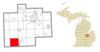
Maple Grove Township is a civil township of Saginaw County in the U.S. state of Michigan. The population was 2,668 at the 2010 Census.

Saginaw Charter Township, Michigan Charter township in Michigan, United States

Saginaw Charter Township is a charter township of Saginaw County in the U.S. state of Michigan. The population was 40,840 at the 2010 census. The city of Saginaw is adjacent to the township to the southeast, but is administratively autonomous.

Angora Township, St. Louis County, Minnesota Township in Minnesota, United States

Angora Township is a township in Saint Louis County, Minnesota, United States. The population was 249 at the 2010 census. Angora Township was named after Angora, in Turkey.

Brevator Township, St. Louis County, Minnesota Township in Minnesota, United States

Brevator Township is a township in Saint Louis County, Minnesota, United States. The population was 1,269 at the 2010 census.

Canosia Township, St. Louis County, Minnesota Township in Minnesota, United States

Canosia Township is a township in Saint Louis County, Minnesota, United States. Canosia is a name derived from the Algonquian language meaning "pike fish". The population was 2,158 at the 2010 census.

Cherry Township, St. Louis County, Minnesota Township in Minnesota, United States

Cherry Township is a township in Saint Louis County, Minnesota, United States. The population was 860 at the 2010 census.

Culver Township, St. Louis County, Minnesota Township in Saint Louis County, Minnesota, United States

Culver Township is a township in Saint Louis County, Minnesota, United States. The population was 294 at the 2010 census.

Fairbanks Township, St. Louis County, Minnesota Township in Minnesota, United States

Fairbanks Township is a township in Saint Louis County, Minnesota, United States. The population was 63 at the 2010 census.

Gnesen Township, St. Louis County, Minnesota Township in Minnesota, United States

Gnesen Township is a township in Saint Louis County, Minnesota, United States. The population was 1,683 at the 2010 census.

Grand Lake Township, St. Louis County, Minnesota Township in Minnesota, United States

Grand Lake Township is a township in Saint Louis County, Minnesota, United States. The population was 2,779 at the 2010 census.

Great Scott Township, St. Louis County, Minnesota Township in Minnesota, United States

Great Scott Township is a township in Saint Louis County, Minnesota, United States. The population was 561 at the 2010 census.

Ness Township, St. Louis County, Minnesota Township in Minnesota, United States

Ness Township is a township in Saint Louis County, Minnesota, United States. The population was 62 at the 2010 census.

New Independence Township, St. Louis County, Minnesota Township in Minnesota, United States

New Independence Township is a township in Saint Louis County, Minnesota, United States. The population was 299 at the 2010 census.

Normanna Township, St. Louis County, Minnesota Township in Minnesota, United States

Normanna Township is a township in Saint Louis County, Minnesota, United States. The population was 796 at the 2010 census.

Northland Township, St. Louis County, Minnesota Township in Minnesota, United States

Northland Township is a township in Saint Louis County, Minnesota, United States. The population was 169 at the 2010 census.

Solway Township, St. Louis County, Minnesota Township in Minnesota, United States

Solway Township is a township in Saint Louis County, Minnesota, United States. The population was 1,944 at the 2010 census. Solway Township was named after Solway Firth.

Stoney Brook Township, St. Louis County, Minnesota Township in Minnesota, United States

Stoney Brook Township is a township in Saint Louis County, Minnesota, United States. The population was 332 at the 2010 census.

Vermilion Lake Township, St. Louis County, Minnesota Township in Minnesota, United States

Vermilion Lake Township is a township in Saint Louis County, Minnesota, United States. The population was 278 at the 2010 census.

References

  1. 1 2 "U.S. Census website". United States Census Bureau . Retrieved 2008-01-31.
  2. "US Board on Geographic Names". United States Geological Survey. 2007-10-25. Retrieved 2008-01-31.
  3. "Race, Hispanic or Latino, Age, and Housing Occupancy: 2010 Census Redistricting Data (Public Law 94-171) Summary File (QT-PL), Industrial township, St. Louis County, Minnesota". United States Census Bureau . Retrieved October 26, 2011.